Landing Instance
API endpoint that allows Landings to be viewed.
GET: Return a list of all the existing landings.
MODE: Normal, Detailed, and List /2.2.0/landings/?mode=detailed
FILTERS: Fields - 'attempt', 'success', 'landing_location__ids', 'landing_type__ids', 'spacecraft__ids', 'launcher__ids', 'spacecraft_launch__ids', 'firststage_launch__ids', 'spacecraft_config__ids', 'launcher_config__ids', 'launcher_serial_numbers'
Get all Landings with the launcher serial number of B1049. Example - /2.2.0/landings/?launcher_serial_numbers=B1049
ORDERING: Fields - 'id', 'downrange_distance' Example - /2.2.0/landings/?ordering=-downrange_distance
GET /2.2.0/landings/209/?format=api
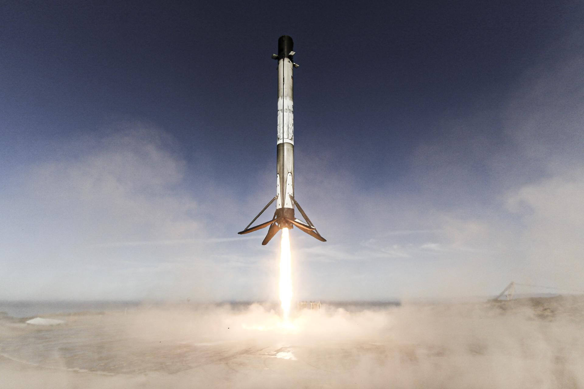
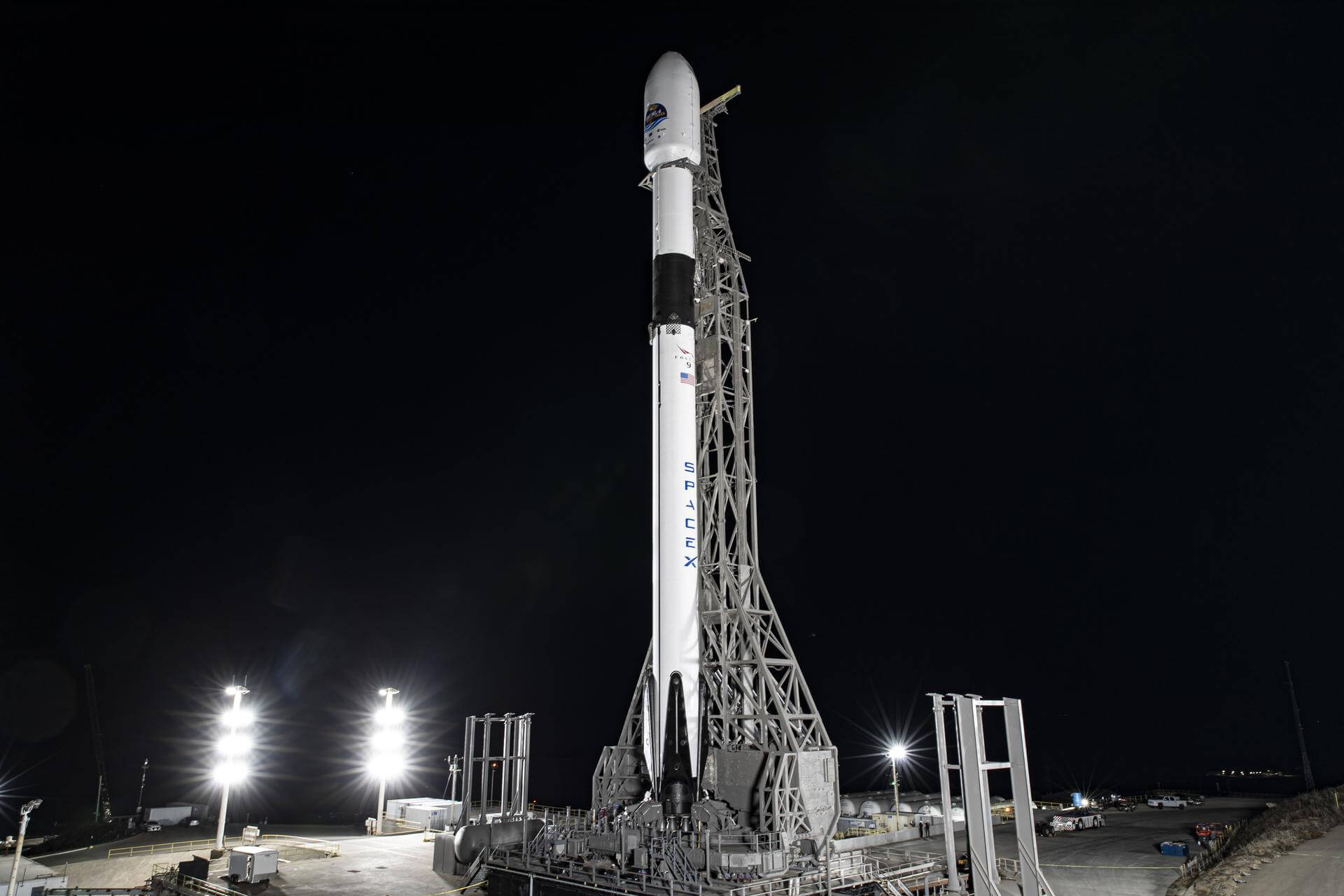
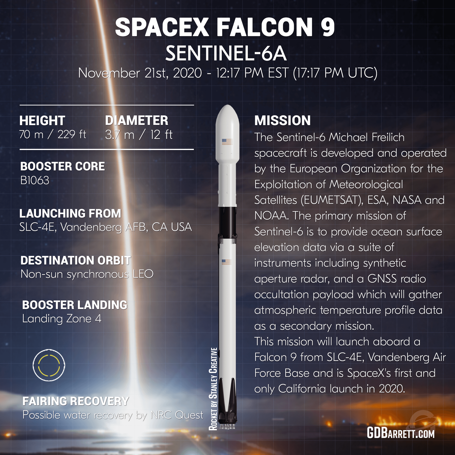
{ "id": 209, "url": "https://ll.thespacedevs.com/2.2.0/landings/209/?format=api", "attempt": true, "success": true, "description": "B1063 has successfully landed on ASDS JRTI after its second launch.", "downrange_distance": 631.0, "landing_type": { "id": 1, "name": "Autonomous Spaceport Drone Ship", "abbrev": "ASDS", "description": "An autonomous spaceport drone ship (ASDS) is an ocean-going vessel derived from a deck barge, outfitted with station-keeping engines and a large landing platform. Construction of such ships was commissioned by aerospace company SpaceX to allow for recovery of rocket first-stages at sea for high-velocity missions which do not carry enough fuel to return to the launch site after lofting spacecraft onto an orbital trajectory." }, "landing_location": { "id": 3, "name": "Just Read the Instructions", "abbrev": "JRTI", "description": "Third (Marmac 303) ASDS barge, Just Read the Instructions (JRTI) is currently used to recover Falcon 9 and Heavy boosters in the Atlantic Ocean.", "location": null, "successful_landings": 156 }, "firststage": { "id": 178, "type": "Core", "reused": true, "launcher_flight_number": 2, "launcher": { "id": 84, "url": "https://ll.thespacedevs.com/2.2.0/launcher/84/?format=api", "details": "Notable launches include Sentinel-6 and Dart.", "flight_proven": true, "serial_number": "B1063", "status": "active", "image_url": "https://thespacedevs-prod.nyc3.digitaloceanspaces.com/media/images/84_image_20201122121517.jpeg", "successful_landings": 32, "attempted_landings": 32, "flights": 32, "last_launch_date": "2026-04-11T05:04:19Z", "first_launch_date": "2020-11-21T17:17:08Z" }, "previous_flight_date": "2020-11-21T17:17:08Z", "turn_around_time_days": 186, "previous_flight": { "id": "56623c2d-7174-489c-b0ed-bf6f039b2412", "url": "https://ll.thespacedevs.com/2.2.0/launch/56623c2d-7174-489c-b0ed-bf6f039b2412/?format=api", "slug": "falcon-9-block-5-sentinel-6-michael-freilich", "name": "Falcon 9 Block 5 | Sentinel-6 Michael Freilich", "status": { "id": 3, "name": "Launch Successful", "abbrev": "Success", "description": "The launch vehicle successfully inserted its payload(s) into the target orbit(s)." }, "last_updated": "2024-06-15T14:12:12Z", "net": "2020-11-21T17:17:08Z", "window_end": "2020-11-21T17:17:08Z", "window_start": "2020-11-21T17:17:08Z", "net_precision": { "id": 0, "name": "Second", "abbrev": "SEC", "description": "The T-0 is accurate to the second." }, "probability": 80, "weather_concerns": null, "holdreason": "", "failreason": "", "hashtag": "#SeeingTheSeas", "launch_service_provider": { "id": 121, "url": "https://ll.thespacedevs.com/2.2.0/agencies/121/?format=api", "name": "SpaceX", "type": "Commercial" }, "rocket": { "id": 164, "configuration": { "id": 164, "url": "https://ll.thespacedevs.com/2.2.0/config/launcher/164/?format=api", "name": "Falcon 9", "family": "Falcon", "full_name": "Falcon 9 Block 5", "variant": "Block 5" } }, "mission": { "id": 910, "name": "Sentinel-6 Michael Freilich (Sentinel-6A; Jason-CS)", "description": "The Sentinel-6 Michael Freilich and Sentinel-6B make up the Sentinel-6 mission, also known as Jason Continuity of Service (Jason-CS), which is a partnership between NASA, NOAA, ESA, and EUMETSAT. This mission continues the long-term global sea surface height data record begun by first Jason satellites in 1992. \r\n\r\nNamed after former NASA Earth Science Division Director Michael Freilich, Sentinel-6 Michail Freilich will provide altimeter data necessary for ocean climate monitoring, ocean modelling and numerical ocean prediction, weather forecasting, marine meteorology, coastal altimetry and modelling. A secondary objective of the mission is to collect high-resolution vertical profiles of temperature, using the Global Navigation Satellite System (GNSS) Radio-Occultation sounding technique, to assess temperature changes in the troposphere and stratosphere and to support numerical weather prediction.\r\n\r\nSentinel-6 Michael Freilich is to operate in a highly-inclined circular orbit at an altitude of 1336 km, with an operational mission lasting 5 years. Near-identical Sentinel-6B is planned to follow-up shortly after.", "launch_designator": null, "type": "Earth Science", "orbit": { "id": 8, "name": "Low Earth Orbit", "abbrev": "LEO" }, "agencies": [], "info_urls": [], "vid_urls": [] }, "pad": { "id": 16, "url": "https://ll.thespacedevs.com/2.2.0/pad/16/?format=api", "agency_id": null, "name": "Space Launch Complex 4E", "description": "Space Launch Complex 4 East (SLC-4E) is a launch site at Vandenberg Space Force Base, California, U.S.\r\n\r\nThe pad was previously used by Atlas and Titan rockets between 1963 and 2005. The pad was built for use by Atlas-Agena rockets, but was later rebuilt to handle Titan rockets.", "info_url": null, "wiki_url": "https://en.wikipedia.org/wiki/Vandenberg_Space_Launch_Complex_4#SLC-4E", "map_url": "https://www.google.com/maps?q=34.632,-120.611", "latitude": "34.632", "longitude": "-120.611", "location": { "id": 11, "url": "https://ll.thespacedevs.com/2.2.0/location/11/?format=api", "name": "Vandenberg SFB, CA, USA", "country_code": "USA", "description": "Vandenberg Space Force Base is a United States Space Force Base in Santa Barbara County, California. Established in 1941, Vandenberg Space Force Base is a space launch base, launching spacecraft from the Western Range, and also performs missile testing. The United States Space Force's Space Launch Delta 30 serves as the host delta for the base, equivalent to an Air Force air base wing. In addition to its military space launch mission, Vandenberg Space Force Base also hosts space launches for civil and commercial space entities, such as NASA and SpaceX.", "map_image": "https://thespacedevs-prod.nyc3.digitaloceanspaces.com/media/map_images/location_11_20200803142416.jpg", "timezone_name": "America/Los_Angeles", "total_launch_count": 889, "total_landing_count": 34 }, "country_code": "USA", "map_image": "https://thespacedevs-prod.nyc3.digitaloceanspaces.com/media/map_images/pad_16_20200803143532.jpg", "total_launch_count": 273, "orbital_launch_attempt_count": 273 }, "webcast_live": false, "image": "https://thespacedevs-prod.nyc3.digitaloceanspaces.com/media/images/falcon2520925_image_20201121073649.jpeg", "infographic": "https://thespacedevs-prod.nyc3.digitaloceanspaces.com/media/infographic_images/falcon2520925_infographic_20201120193858.png", "program": [ { "id": 22, "url": "https://ll.thespacedevs.com/2.2.0/program/22/?format=api", "name": "Copernicus", "description": "Copernicus is the European Union's Earth observation programme coordinated and managed for the European Commission by the European Union Agency for the Space Programme in partnership with the European Space Agency (ESA), the EU Member States. It aims at achieving a global, continuous, autonomous, high quality, wide range Earth observation capacity. Providing accurate, timely and easily accessible information to, among other things, improve the management of the environment, understand and mitigate the effects of climate change, and ensure civil security.", "agencies": [ { "id": 27, "url": "https://ll.thespacedevs.com/2.2.0/agencies/27/?format=api", "name": "European Space Agency", "type": "Multinational" }, { "id": 1043, "url": "https://ll.thespacedevs.com/2.2.0/agencies/1043/?format=api", "name": "European Union Agency for the Space Programme", "type": "Multinational" } ], "image_url": "https://thespacedevs-prod.nyc3.digitaloceanspaces.com/media/images/copernicus_program_20221129162831.png", "start_date": "2014-04-03T00:00:00Z", "end_date": null, "info_url": "https://www.copernicus.eu", "wiki_url": "https://en.wikipedia.org/wiki/Copernicus_Programme", "mission_patches": [], "type": { "id": 8, "name": "Earth Observation" } } ], "orbital_launch_attempt_count": 6017, "location_launch_attempt_count": 687, "pad_launch_attempt_count": 84, "agency_launch_attempt_count": 112, "orbital_launch_attempt_count_year": 95, "location_launch_attempt_count_year": 1, "pad_launch_attempt_count_year": 1, "agency_launch_attempt_count_year": 24, "type": "normal" } }, "spacecraftflight": null }