Launch List
AN API endpoint that returns all Launch objects or a single launch.
EXAMPLE - /launch/[id]/ or /launch/?mode=list&search=SpaceX
GET Return a list of all Launch objects.
FILTERS Fields - 'name', 'id(s)', 'lsp__id', 'lsp__name', 'serial_number', 'launcher_config__id', 'rocket__spacecraftflight__spacecraft__name', 'is_crewed', 'include_suborbital', 'spacecraft_config__ids', 'related', 'location__ids', 'lsp__ids', 'pad__ids', 'status__ids'
MODE 'normal', 'list', 'detailed'
EXAMPLE ?mode=list
SEARCH Searches through the launch name, rocket name, launch agency, mission name & spacecraft name.
EXAMPLE - ?search=SpaceX
GET /2.2.0/launch/?format=api&offset=4380&ordering=last_updated
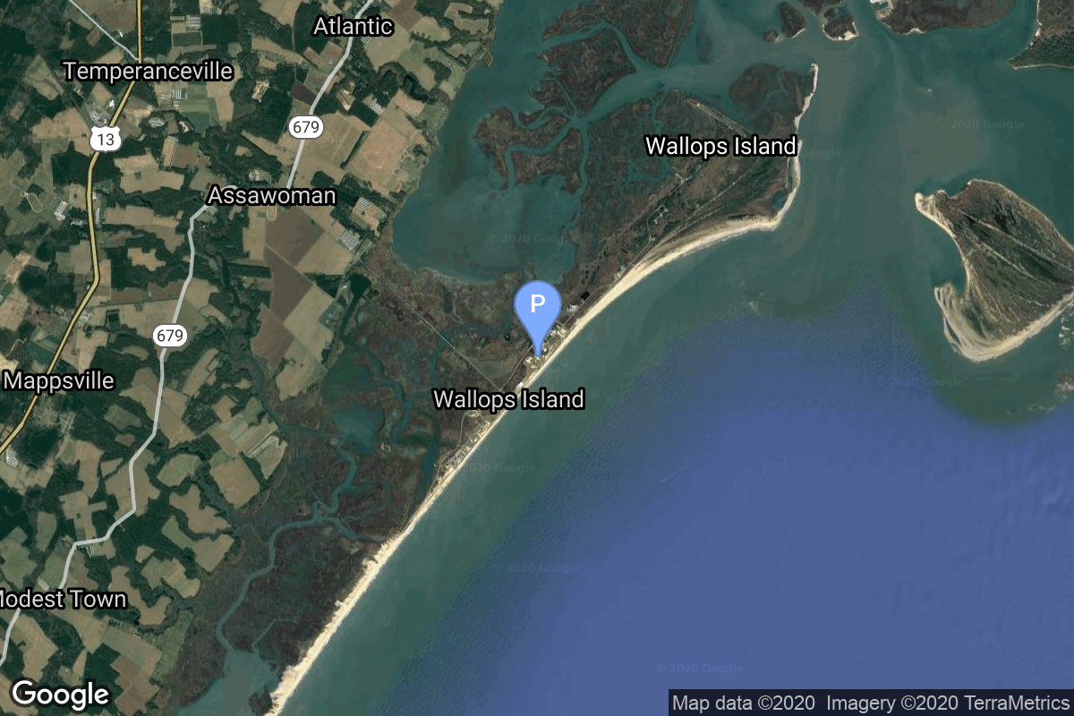
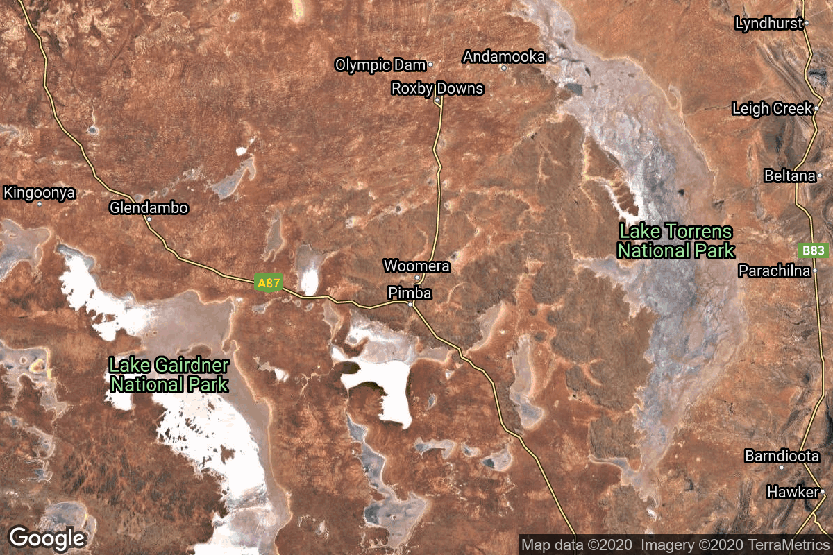
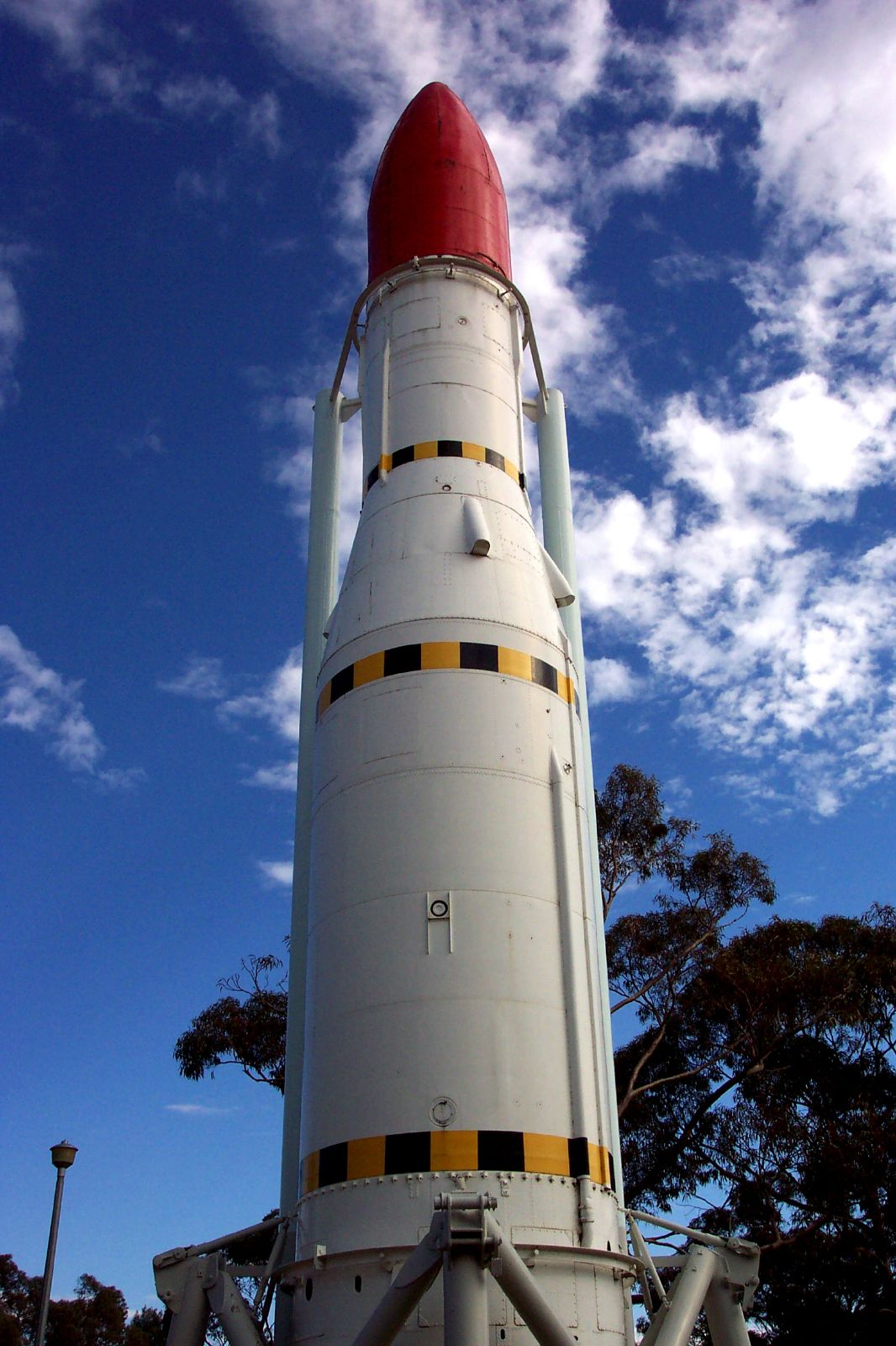
{ "count": 7507, "next": "https://ll.thespacedevs.com/2.2.0/launch/?format=api&limit=10&offset=4390&ordering=last_updated", "previous": "https://ll.thespacedevs.com/2.2.0/launch/?format=api&limit=10&offset=4370&ordering=last_updated", "results": [ { "id": "bccb0e4e-6b67-45c6-9af5-4c3007a99981", "url": "https://ll.thespacedevs.com/2.2.0/launch/bccb0e4e-6b67-45c6-9af5-4c3007a99981/?format=api", "slug": "scout-b-explorer-37", "name": "Scout B | Explorer 37", "status": { "id": 3, "name": "Launch Successful", "abbrev": "Success", "description": "The launch vehicle successfully inserted its payload(s) into the target orbit(s)." }, "last_updated": "2023-06-14T04:29:56Z", "net": "1968-03-05T18:28:00Z", "window_end": "1968-03-05T18:28:00Z", "window_start": "1968-03-05T18:28:00Z", "net_precision": null, "probability": null, "weather_concerns": null, "holdreason": "", "failreason": null, "hashtag": null, "launch_service_provider": { "id": 44, "url": "https://ll.thespacedevs.com/2.2.0/agencies/44/?format=api", "name": "National Aeronautics and Space Administration", "type": "Government" }, "rocket": { "id": 3758, "configuration": { "id": 358, "url": "https://ll.thespacedevs.com/2.2.0/config/launcher/358/?format=api", "name": "Scout B", "family": "Scout", "full_name": "Scout B", "variant": "B" } }, "mission": { "id": 2176, "name": "Explorer 37", "description": "Solar science satellite inserted into an off-nominal orbit.", "launch_designator": null, "type": "Astrophysics", "orbit": { "id": 8, "name": "Low Earth Orbit", "abbrev": "LEO" }, "agencies": [], "info_urls": [], "vid_urls": [] }, "pad": { "id": 178, "url": "https://ll.thespacedevs.com/2.2.0/pad/178/?format=api", "agency_id": null, "name": "Launch Area 3A", "description": null, "info_url": null, "wiki_url": null, "map_url": "https://www.google.com/maps?q=37.8495,-75.4725", "latitude": "37.8495", "longitude": "-75.4725", "location": { "id": 21, "url": "https://ll.thespacedevs.com/2.2.0/location/21/?format=api", "name": "Wallops Flight Facility, Virginia, USA", "country_code": "USA", "description": "Wallops Flight Facility is a rocket launch site on Wallops Island on the Eastern Shore of Virginia, United States, just east of the Delmarva Peninsula and north-northeast of Norfolk. The facility is operated by the Goddard Space Flight Center in Greenbelt, Maryland, and primarily serves to support science and exploration missions for NASA and other federal agencies. WFF includes an extensively instrumented range to support launches of more than a dozen types of sounding rockets; small expendable suborbital and orbital rockets; high-altitude balloon flights carrying scientific instruments for atmospheric and astronomical research; and, using its Research Airport, flight tests of aeronautical research aircraft, including uncrewed aerial vehicles.", "map_image": "https://thespacedevs-prod.nyc3.digitaloceanspaces.com/media/map_images/location_21_20200803142423.jpg", "timezone_name": "America/New_York", "total_launch_count": 80, "total_landing_count": 0 }, "country_code": "USA", "map_image": "https://thespacedevs-prod.nyc3.digitaloceanspaces.com/media/map_images/pad_178_20200803143407.jpg", "total_launch_count": 18, "orbital_launch_attempt_count": 13 }, "webcast_live": false, "image": null, "infographic": null, "program": [], "orbital_launch_attempt_count": 806, "location_launch_attempt_count": 37, "pad_launch_attempt_count": 8, "agency_launch_attempt_count": 92, "orbital_launch_attempt_count_year": 18, "location_launch_attempt_count_year": 1, "pad_launch_attempt_count_year": 1, "agency_launch_attempt_count_year": 2, "type": "normal" }, { "id": "b13cb911-f713-4e56-a6c9-777e6147162e", "url": "https://ll.thespacedevs.com/2.2.0/launch/b13cb911-f713-4e56-a6c9-777e6147162e/?format=api", "slug": "scout-b-ofo", "name": "Scout B | OFO", "status": { "id": 3, "name": "Launch Successful", "abbrev": "Success", "description": "The launch vehicle successfully inserted its payload(s) into the target orbit(s)." }, "last_updated": "2023-06-14T04:29:56Z", "net": "1970-11-09T06:00:00Z", "window_end": "1970-11-09T06:00:00Z", "window_start": "1970-11-09T06:00:00Z", "net_precision": null, "probability": null, "weather_concerns": null, "holdreason": "", "failreason": null, "hashtag": null, "launch_service_provider": { "id": 44, "url": "https://ll.thespacedevs.com/2.2.0/agencies/44/?format=api", "name": "National Aeronautics and Space Administration", "type": "Government" }, "rocket": { "id": 4069, "configuration": { "id": 358, "url": "https://ll.thespacedevs.com/2.2.0/config/launcher/358/?format=api", "name": "Scout B", "family": "Scout", "full_name": "Scout B", "variant": "B" } }, "mission": { "id": 2487, "name": "OFO", "description": "Life-science satellite carrying two bullfrogs and measuring their bioelectric action potential during weightlessness and gravity stimulus obtained by activation of a centrifuge.", "launch_designator": null, "type": "Biology", "orbit": { "id": 8, "name": "Low Earth Orbit", "abbrev": "LEO" }, "agencies": [], "info_urls": [], "vid_urls": [] }, "pad": { "id": 178, "url": "https://ll.thespacedevs.com/2.2.0/pad/178/?format=api", "agency_id": null, "name": "Launch Area 3A", "description": null, "info_url": null, "wiki_url": null, "map_url": "https://www.google.com/maps?q=37.8495,-75.4725", "latitude": "37.8495", "longitude": "-75.4725", "location": { "id": 21, "url": "https://ll.thespacedevs.com/2.2.0/location/21/?format=api", "name": "Wallops Flight Facility, Virginia, USA", "country_code": "USA", "description": "Wallops Flight Facility is a rocket launch site on Wallops Island on the Eastern Shore of Virginia, United States, just east of the Delmarva Peninsula and north-northeast of Norfolk. The facility is operated by the Goddard Space Flight Center in Greenbelt, Maryland, and primarily serves to support science and exploration missions for NASA and other federal agencies. WFF includes an extensively instrumented range to support launches of more than a dozen types of sounding rockets; small expendable suborbital and orbital rockets; high-altitude balloon flights carrying scientific instruments for atmospheric and astronomical research; and, using its Research Airport, flight tests of aeronautical research aircraft, including uncrewed aerial vehicles.", "map_image": "https://thespacedevs-prod.nyc3.digitaloceanspaces.com/media/map_images/location_21_20200803142423.jpg", "timezone_name": "America/New_York", "total_launch_count": 80, "total_landing_count": 0 }, "country_code": "USA", "map_image": "https://thespacedevs-prod.nyc3.digitaloceanspaces.com/media/map_images/pad_178_20200803143407.jpg", "total_launch_count": 18, "orbital_launch_attempt_count": 13 }, "webcast_live": false, "image": null, "infographic": null, "program": [], "orbital_launch_attempt_count": 1149, "location_launch_attempt_count": 39, "pad_launch_attempt_count": 10, "agency_launch_attempt_count": 105, "orbital_launch_attempt_count_year": 103, "location_launch_attempt_count_year": 1, "pad_launch_attempt_count_year": 1, "agency_launch_attempt_count_year": 2, "type": "normal" }, { "id": "e3304c50-0843-423c-8a2c-389120395cd8", "url": "https://ll.thespacedevs.com/2.2.0/launch/e3304c50-0843-423c-8a2c-389120395cd8/?format=api", "slug": "scout-d-1-explorer-46", "name": "Scout D-1 | Explorer 46", "status": { "id": 3, "name": "Launch Successful", "abbrev": "Success", "description": "The launch vehicle successfully inserted its payload(s) into the target orbit(s)." }, "last_updated": "2023-06-14T04:29:56Z", "net": "1972-08-13T15:10:00Z", "window_end": "1972-08-13T15:10:00Z", "window_start": "1972-08-13T15:10:00Z", "net_precision": null, "probability": null, "weather_concerns": null, "holdreason": "", "failreason": null, "hashtag": null, "launch_service_provider": { "id": 44, "url": "https://ll.thespacedevs.com/2.2.0/agencies/44/?format=api", "name": "National Aeronautics and Space Administration", "type": "Government" }, "rocket": { "id": 4282, "configuration": { "id": 360, "url": "https://ll.thespacedevs.com/2.2.0/config/launcher/360/?format=api", "name": "Scout D-1", "family": "Scout", "full_name": "Scout D-1", "variant": "D-1" } }, "mission": { "id": 2700, "name": "Explorer 46", "description": "Satellite dedicated to meteroid research", "launch_designator": null, "type": "Astrophysics", "orbit": { "id": 8, "name": "Low Earth Orbit", "abbrev": "LEO" }, "agencies": [], "info_urls": [], "vid_urls": [] }, "pad": { "id": 178, "url": "https://ll.thespacedevs.com/2.2.0/pad/178/?format=api", "agency_id": null, "name": "Launch Area 3A", "description": null, "info_url": null, "wiki_url": null, "map_url": "https://www.google.com/maps?q=37.8495,-75.4725", "latitude": "37.8495", "longitude": "-75.4725", "location": { "id": 21, "url": "https://ll.thespacedevs.com/2.2.0/location/21/?format=api", "name": "Wallops Flight Facility, Virginia, USA", "country_code": "USA", "description": "Wallops Flight Facility is a rocket launch site on Wallops Island on the Eastern Shore of Virginia, United States, just east of the Delmarva Peninsula and north-northeast of Norfolk. The facility is operated by the Goddard Space Flight Center in Greenbelt, Maryland, and primarily serves to support science and exploration missions for NASA and other federal agencies. WFF includes an extensively instrumented range to support launches of more than a dozen types of sounding rockets; small expendable suborbital and orbital rockets; high-altitude balloon flights carrying scientific instruments for atmospheric and astronomical research; and, using its Research Airport, flight tests of aeronautical research aircraft, including uncrewed aerial vehicles.", "map_image": "https://thespacedevs-prod.nyc3.digitaloceanspaces.com/media/map_images/location_21_20200803142423.jpg", "timezone_name": "America/New_York", "total_launch_count": 80, "total_landing_count": 0 }, "country_code": "USA", "map_image": "https://thespacedevs-prod.nyc3.digitaloceanspaces.com/media/map_images/pad_178_20200803143407.jpg", "total_launch_count": 18, "orbital_launch_attempt_count": 13 }, "webcast_live": false, "image": null, "infographic": null, "program": [], "orbital_launch_attempt_count": 1373, "location_launch_attempt_count": 43, "pad_launch_attempt_count": 14, "agency_launch_attempt_count": 116, "orbital_launch_attempt_count_year": 67, "location_launch_attempt_count_year": 1, "pad_launch_attempt_count_year": 1, "agency_launch_attempt_count_year": 3, "type": "normal" }, { "id": "40595a20-0c5b-4bc0-9f1a-e36b317e6baf", "url": "https://ll.thespacedevs.com/2.2.0/launch/40595a20-0c5b-4bc0-9f1a-e36b317e6baf/?format=api", "slug": "scout-x-4-beacon-explorer-c", "name": "Scout X-4 | Beacon Explorer C", "status": { "id": 3, "name": "Launch Successful", "abbrev": "Success", "description": "The launch vehicle successfully inserted its payload(s) into the target orbit(s)." }, "last_updated": "2023-06-14T04:29:56Z", "net": "1965-04-29T14:17:00Z", "window_end": "1965-04-29T14:17:00Z", "window_start": "1965-04-29T14:17:00Z", "net_precision": null, "probability": null, "weather_concerns": null, "holdreason": "", "failreason": null, "hashtag": null, "launch_service_provider": { "id": 44, "url": "https://ll.thespacedevs.com/2.2.0/agencies/44/?format=api", "name": "National Aeronautics and Space Administration", "type": "Government" }, "rocket": { "id": 3388, "configuration": { "id": 370, "url": "https://ll.thespacedevs.com/2.2.0/config/launcher/370/?format=api", "name": "Scout X-4", "family": "Scout", "full_name": "Scout X-4", "variant": "4" } }, "mission": { "id": 1809, "name": "Beacon Explorer C", "description": "The BE (Beacon Explorer) satellites provided Laser reflectors for geodetic measurements as well measured the electron density in the ionosphere.", "launch_designator": null, "type": "Earth Science", "orbit": { "id": 8, "name": "Low Earth Orbit", "abbrev": "LEO" }, "agencies": [], "info_urls": [], "vid_urls": [] }, "pad": { "id": 178, "url": "https://ll.thespacedevs.com/2.2.0/pad/178/?format=api", "agency_id": null, "name": "Launch Area 3A", "description": null, "info_url": null, "wiki_url": null, "map_url": "https://www.google.com/maps?q=37.8495,-75.4725", "latitude": "37.8495", "longitude": "-75.4725", "location": { "id": 21, "url": "https://ll.thespacedevs.com/2.2.0/location/21/?format=api", "name": "Wallops Flight Facility, Virginia, USA", "country_code": "USA", "description": "Wallops Flight Facility is a rocket launch site on Wallops Island on the Eastern Shore of Virginia, United States, just east of the Delmarva Peninsula and north-northeast of Norfolk. The facility is operated by the Goddard Space Flight Center in Greenbelt, Maryland, and primarily serves to support science and exploration missions for NASA and other federal agencies. WFF includes an extensively instrumented range to support launches of more than a dozen types of sounding rockets; small expendable suborbital and orbital rockets; high-altitude balloon flights carrying scientific instruments for atmospheric and astronomical research; and, using its Research Airport, flight tests of aeronautical research aircraft, including uncrewed aerial vehicles.", "map_image": "https://thespacedevs-prod.nyc3.digitaloceanspaces.com/media/map_images/location_21_20200803142423.jpg", "timezone_name": "America/New_York", "total_launch_count": 80, "total_landing_count": 0 }, "country_code": "USA", "map_image": "https://thespacedevs-prod.nyc3.digitaloceanspaces.com/media/map_images/pad_178_20200803143407.jpg", "total_launch_count": 18, "orbital_launch_attempt_count": 13 }, "webcast_live": false, "image": null, "infographic": null, "program": [], "orbital_launch_attempt_count": 430, "location_launch_attempt_count": 27, "pad_launch_attempt_count": 2, "agency_launch_attempt_count": 64, "orbital_launch_attempt_count_year": 37, "location_launch_attempt_count_year": 1, "pad_launch_attempt_count_year": 1, "agency_launch_attempt_count_year": 3, "type": "normal" }, { "id": "71c0bbc5-1516-44f8-ba30-f31a3ee5aa60", "url": "https://ll.thespacedevs.com/2.2.0/launch/71c0bbc5-1516-44f8-ba30-f31a3ee5aa60/?format=api", "slug": "scout-d-1-sage", "name": "Scout D-1 | SAGE", "status": { "id": 3, "name": "Launch Successful", "abbrev": "Success", "description": "The launch vehicle successfully inserted its payload(s) into the target orbit(s)." }, "last_updated": "2023-06-14T04:29:56Z", "net": "1979-02-18T16:18:00Z", "window_end": "1979-02-18T16:18:00Z", "window_start": "1979-02-18T16:18:00Z", "net_precision": null, "probability": null, "weather_concerns": null, "holdreason": "", "failreason": null, "hashtag": null, "launch_service_provider": { "id": 44, "url": "https://ll.thespacedevs.com/2.2.0/agencies/44/?format=api", "name": "National Aeronautics and Space Administration", "type": "Government" }, "rocket": { "id": 5046, "configuration": { "id": 360, "url": "https://ll.thespacedevs.com/2.2.0/config/launcher/360/?format=api", "name": "Scout D-1", "family": "Scout", "full_name": "Scout D-1", "variant": "D-1" } }, "mission": { "id": 3459, "name": "SAGE", "description": "Stratospheric research satellite", "launch_designator": null, "type": "Earth Science", "orbit": { "id": 8, "name": "Low Earth Orbit", "abbrev": "LEO" }, "agencies": [], "info_urls": [], "vid_urls": [] }, "pad": { "id": 178, "url": "https://ll.thespacedevs.com/2.2.0/pad/178/?format=api", "agency_id": null, "name": "Launch Area 3A", "description": null, "info_url": null, "wiki_url": null, "map_url": "https://www.google.com/maps?q=37.8495,-75.4725", "latitude": "37.8495", "longitude": "-75.4725", "location": { "id": 21, "url": "https://ll.thespacedevs.com/2.2.0/location/21/?format=api", "name": "Wallops Flight Facility, Virginia, USA", "country_code": "USA", "description": "Wallops Flight Facility is a rocket launch site on Wallops Island on the Eastern Shore of Virginia, United States, just east of the Delmarva Peninsula and north-northeast of Norfolk. The facility is operated by the Goddard Space Flight Center in Greenbelt, Maryland, and primarily serves to support science and exploration missions for NASA and other federal agencies. WFF includes an extensively instrumented range to support launches of more than a dozen types of sounding rockets; small expendable suborbital and orbital rockets; high-altitude balloon flights carrying scientific instruments for atmospheric and astronomical research; and, using its Research Airport, flight tests of aeronautical research aircraft, including uncrewed aerial vehicles.", "map_image": "https://thespacedevs-prod.nyc3.digitaloceanspaces.com/media/map_images/location_21_20200803142423.jpg", "timezone_name": "America/New_York", "total_launch_count": 80, "total_landing_count": 0 }, "country_code": "USA", "map_image": "https://thespacedevs-prod.nyc3.digitaloceanspaces.com/media/map_images/pad_178_20200803143407.jpg", "total_launch_count": 18, "orbital_launch_attempt_count": 13 }, "webcast_live": false, "image": null, "infographic": null, "program": [], "orbital_launch_attempt_count": 2187, "location_launch_attempt_count": 45, "pad_launch_attempt_count": 16, "agency_launch_attempt_count": 133, "orbital_launch_attempt_count_year": 14, "location_launch_attempt_count_year": 1, "pad_launch_attempt_count_year": 1, "agency_launch_attempt_count_year": 1, "type": "normal" }, { "id": "0a77db2e-49a9-4961-bde0-54535a3e4fb1", "url": "https://ll.thespacedevs.com/2.2.0/launch/0a77db2e-49a9-4961-bde0-54535a3e4fb1/?format=api", "slug": "scout-b-solrad-10", "name": "Scout B | Solrad 10", "status": { "id": 3, "name": "Launch Successful", "abbrev": "Success", "description": "The launch vehicle successfully inserted its payload(s) into the target orbit(s)." }, "last_updated": "2023-06-14T04:29:57Z", "net": "1971-07-08T22:58:00Z", "window_end": "1971-07-08T22:58:00Z", "window_start": "1971-07-08T22:58:00Z", "net_precision": null, "probability": null, "weather_concerns": null, "holdreason": "", "failreason": null, "hashtag": null, "launch_service_provider": { "id": 44, "url": "https://ll.thespacedevs.com/2.2.0/agencies/44/?format=api", "name": "National Aeronautics and Space Administration", "type": "Government" }, "rocket": { "id": 4150, "configuration": { "id": 358, "url": "https://ll.thespacedevs.com/2.2.0/config/launcher/358/?format=api", "name": "Scout B", "family": "Scout", "full_name": "Scout B", "variant": "B" } }, "mission": { "id": 2568, "name": "Solrad 10", "description": "Satellite designed to provide continuous coverage of wavelength and intensity changes in solar radiation.", "launch_designator": null, "type": "Heliophysics", "orbit": { "id": 8, "name": "Low Earth Orbit", "abbrev": "LEO" }, "agencies": [], "info_urls": [], "vid_urls": [] }, "pad": { "id": 178, "url": "https://ll.thespacedevs.com/2.2.0/pad/178/?format=api", "agency_id": null, "name": "Launch Area 3A", "description": null, "info_url": null, "wiki_url": null, "map_url": "https://www.google.com/maps?q=37.8495,-75.4725", "latitude": "37.8495", "longitude": "-75.4725", "location": { "id": 21, "url": "https://ll.thespacedevs.com/2.2.0/location/21/?format=api", "name": "Wallops Flight Facility, Virginia, USA", "country_code": "USA", "description": "Wallops Flight Facility is a rocket launch site on Wallops Island on the Eastern Shore of Virginia, United States, just east of the Delmarva Peninsula and north-northeast of Norfolk. The facility is operated by the Goddard Space Flight Center in Greenbelt, Maryland, and primarily serves to support science and exploration missions for NASA and other federal agencies. WFF includes an extensively instrumented range to support launches of more than a dozen types of sounding rockets; small expendable suborbital and orbital rockets; high-altitude balloon flights carrying scientific instruments for atmospheric and astronomical research; and, using its Research Airport, flight tests of aeronautical research aircraft, including uncrewed aerial vehicles.", "map_image": "https://thespacedevs-prod.nyc3.digitaloceanspaces.com/media/map_images/location_21_20200803142423.jpg", "timezone_name": "America/New_York", "total_launch_count": 80, "total_landing_count": 0 }, "country_code": "USA", "map_image": "https://thespacedevs-prod.nyc3.digitaloceanspaces.com/media/map_images/pad_178_20200803143407.jpg", "total_launch_count": 18, "orbital_launch_attempt_count": 13 }, "webcast_live": false, "image": null, "infographic": null, "program": [], "orbital_launch_attempt_count": 1236, "location_launch_attempt_count": 40, "pad_launch_attempt_count": 11, "agency_launch_attempt_count": 109, "orbital_launch_attempt_count_year": 65, "location_launch_attempt_count_year": 1, "pad_launch_attempt_count_year": 1, "agency_launch_attempt_count_year": 3, "type": "normal" }, { "id": "9afd4292-105f-427e-9693-157cdc8ca096", "url": "https://ll.thespacedevs.com/2.2.0/launch/9afd4292-105f-427e-9693-157cdc8ca096/?format=api", "slug": "scout-d-1-ariel-6", "name": "Scout D-1 | Ariel 6", "status": { "id": 3, "name": "Launch Successful", "abbrev": "Success", "description": "The launch vehicle successfully inserted its payload(s) into the target orbit(s)." }, "last_updated": "2023-06-14T04:29:57Z", "net": "1979-06-02T23:26:00Z", "window_end": "1979-06-02T23:26:00Z", "window_start": "1979-06-02T23:26:00Z", "net_precision": null, "probability": null, "weather_concerns": null, "holdreason": "", "failreason": null, "hashtag": null, "launch_service_provider": { "id": 1017, "url": "https://ll.thespacedevs.com/2.2.0/agencies/1017/?format=api", "name": "Science and Engineering Research Council", "type": "Government" }, "rocket": { "id": 5076, "configuration": { "id": 360, "url": "https://ll.thespacedevs.com/2.2.0/config/launcher/360/?format=api", "name": "Scout D-1", "family": "Scout", "full_name": "Scout D-1", "variant": "D-1" } }, "mission": { "id": 3488, "name": "Ariel 6", "description": "Ariel is a series of British research satellites. Ariel 6 primary experiment was a cosmic ray detector. Satellite also carried X-ray telescopes.", "launch_designator": null, "type": "Astrophysics", "orbit": { "id": 8, "name": "Low Earth Orbit", "abbrev": "LEO" }, "agencies": [], "info_urls": [], "vid_urls": [] }, "pad": { "id": 178, "url": "https://ll.thespacedevs.com/2.2.0/pad/178/?format=api", "agency_id": null, "name": "Launch Area 3A", "description": null, "info_url": null, "wiki_url": null, "map_url": "https://www.google.com/maps?q=37.8495,-75.4725", "latitude": "37.8495", "longitude": "-75.4725", "location": { "id": 21, "url": "https://ll.thespacedevs.com/2.2.0/location/21/?format=api", "name": "Wallops Flight Facility, Virginia, USA", "country_code": "USA", "description": "Wallops Flight Facility is a rocket launch site on Wallops Island on the Eastern Shore of Virginia, United States, just east of the Delmarva Peninsula and north-northeast of Norfolk. The facility is operated by the Goddard Space Flight Center in Greenbelt, Maryland, and primarily serves to support science and exploration missions for NASA and other federal agencies. WFF includes an extensively instrumented range to support launches of more than a dozen types of sounding rockets; small expendable suborbital and orbital rockets; high-altitude balloon flights carrying scientific instruments for atmospheric and astronomical research; and, using its Research Airport, flight tests of aeronautical research aircraft, including uncrewed aerial vehicles.", "map_image": "https://thespacedevs-prod.nyc3.digitaloceanspaces.com/media/map_images/location_21_20200803142423.jpg", "timezone_name": "America/New_York", "total_launch_count": 80, "total_landing_count": 0 }, "country_code": "USA", "map_image": "https://thespacedevs-prod.nyc3.digitaloceanspaces.com/media/map_images/pad_178_20200803143407.jpg", "total_launch_count": 18, "orbital_launch_attempt_count": 13 }, "webcast_live": false, "image": null, "infographic": null, "program": [], "orbital_launch_attempt_count": 2221, "location_launch_attempt_count": 46, "pad_launch_attempt_count": 17, "agency_launch_attempt_count": 6, "orbital_launch_attempt_count_year": 48, "location_launch_attempt_count_year": 2, "pad_launch_attempt_count_year": 2, "agency_launch_attempt_count_year": 1, "type": "normal" }, { "id": "454b8835-f615-41c5-8078-380fffb265fc", "url": "https://ll.thespacedevs.com/2.2.0/launch/454b8835-f615-41c5-8078-380fffb265fc/?format=api", "slug": "black-arrow-prospero", "name": "Black Arrow | Prospero", "status": { "id": 3, "name": "Launch Successful", "abbrev": "Success", "description": "The launch vehicle successfully inserted its payload(s) into the target orbit(s)." }, "last_updated": "2023-06-14T04:29:57Z", "net": "1971-10-28T04:09:29Z", "window_end": "1971-10-28T04:09:29Z", "window_start": "1971-10-28T04:09:29Z", "net_precision": null, "probability": null, "weather_concerns": null, "holdreason": "", "failreason": null, "hashtag": null, "launch_service_provider": { "id": 1005, "url": "https://ll.thespacedevs.com/2.2.0/agencies/1005/?format=api", "name": "Royal Aircraft Establishment", "type": "Government" }, "rocket": { "id": 4188, "configuration": { "id": 263, "url": "https://ll.thespacedevs.com/2.2.0/config/launcher/263/?format=api", "name": "Black Arrow", "family": "", "full_name": "Black Arrow", "variant": "" } }, "mission": { "id": 2606, "name": "Prospero", "description": "British scientific satellite used to demonstrate technologies needed for communication satellites.", "launch_designator": null, "type": "Test Flight", "orbit": { "id": 8, "name": "Low Earth Orbit", "abbrev": "LEO" }, "agencies": [], "info_urls": [], "vid_urls": [] }, "pad": { "id": 179, "url": "https://ll.thespacedevs.com/2.2.0/pad/179/?format=api", "agency_id": null, "name": "Launch Area 5B", "description": null, "info_url": null, "wiki_url": "https://en.wikipedia.org/wiki/RAAF_Woomera_Range_Complex", "map_url": "https://www.google.com/maps?q=-30.9552778,136.5300282", "latitude": "-30.9552778", "longitude": "136.5300282", "location": { "id": 152, "url": "https://ll.thespacedevs.com/2.2.0/location/152/?format=api", "name": "RAAF Woomera Range Complex", "country_code": "AUS", "description": "The RAAF Woomera Range Complex (WRC) is a major Australian military and civil aerospace facility and operation located in South Australia, approximately 450 km (280 mi) north-west of Adelaide. The WRC is operated by the Royal Australian Air Force (RAAF), a Service of the Australian Defence Force (ADF). The complex has a land area of 122,188 km2 (47,177 sq mi) or roughly the size of North Korea or Pennsylvania. The airspace above the area is restricted and controlled by the RAAF for safety and security. The WRC is a highly specialised ADF test and evaluation capability operated by the RAAF for the purposes of testing defence materiel.", "map_image": "https://thespacedevs-prod.nyc3.digitaloceanspaces.com/media/map_images/location_152_20200803142502.jpg", "timezone_name": "Australia/Adelaide", "total_launch_count": 6, "total_landing_count": 0 }, "country_code": "AUS", "map_image": "https://thespacedevs-prod.nyc3.digitaloceanspaces.com/media/map_images/pad_179_20200803143455.jpg", "total_launch_count": 2, "orbital_launch_attempt_count": 2 }, "webcast_live": false, "image": "https://thespacedevs-prod.nyc3.digitaloceanspaces.com/media/images/black_arrow_in__image_20240314095415.jpg", "infographic": null, "program": [], "orbital_launch_attempt_count": 1275, "location_launch_attempt_count": 6, "pad_launch_attempt_count": 2, "agency_launch_attempt_count": 2, "orbital_launch_attempt_count_year": 104, "location_launch_attempt_count_year": 1, "pad_launch_attempt_count_year": 1, "agency_launch_attempt_count_year": 1, "type": "normal" }, { "id": "2d1a819f-e800-4db2-b4a8-23b77d5f63f7", "url": "https://ll.thespacedevs.com/2.2.0/launch/2d1a819f-e800-4db2-b4a8-23b77d5f63f7/?format=api", "slug": "black-arrow-x-2", "name": "Black Arrow | X-2", "status": { "id": 4, "name": "Launch Failure", "abbrev": "Failure", "description": "Either the launch vehicle did not reach orbit, or the payload(s) failed to separate." }, "last_updated": "2023-06-14T04:29:57Z", "net": "1970-09-02T00:34:05Z", "window_end": "1970-09-02T00:34:05Z", "window_start": "1970-09-02T00:34:05Z", "net_precision": null, "probability": null, "weather_concerns": null, "holdreason": "", "failreason": null, "hashtag": null, "launch_service_provider": { "id": 1005, "url": "https://ll.thespacedevs.com/2.2.0/agencies/1005/?format=api", "name": "Royal Aircraft Establishment", "type": "Government" }, "rocket": { "id": 4044, "configuration": { "id": 263, "url": "https://ll.thespacedevs.com/2.2.0/config/launcher/263/?format=api", "name": "Black Arrow", "family": "", "full_name": "Black Arrow", "variant": "" } }, "mission": { "id": 2462, "name": "X-2", "description": "Uninstrumented spherical satellite meant to enable atmospheric density measurements by observing its orbital decay. It was destroyed in the failure of the first Black Arrow orbital launch failure.", "launch_designator": null, "type": "Test Flight", "orbit": { "id": 8, "name": "Low Earth Orbit", "abbrev": "LEO" }, "agencies": [], "info_urls": [], "vid_urls": [] }, "pad": { "id": 179, "url": "https://ll.thespacedevs.com/2.2.0/pad/179/?format=api", "agency_id": null, "name": "Launch Area 5B", "description": null, "info_url": null, "wiki_url": "https://en.wikipedia.org/wiki/RAAF_Woomera_Range_Complex", "map_url": "https://www.google.com/maps?q=-30.9552778,136.5300282", "latitude": "-30.9552778", "longitude": "136.5300282", "location": { "id": 152, "url": "https://ll.thespacedevs.com/2.2.0/location/152/?format=api", "name": "RAAF Woomera Range Complex", "country_code": "AUS", "description": "The RAAF Woomera Range Complex (WRC) is a major Australian military and civil aerospace facility and operation located in South Australia, approximately 450 km (280 mi) north-west of Adelaide. The WRC is operated by the Royal Australian Air Force (RAAF), a Service of the Australian Defence Force (ADF). The complex has a land area of 122,188 km2 (47,177 sq mi) or roughly the size of North Korea or Pennsylvania. The airspace above the area is restricted and controlled by the RAAF for safety and security. The WRC is a highly specialised ADF test and evaluation capability operated by the RAAF for the purposes of testing defence materiel.", "map_image": "https://thespacedevs-prod.nyc3.digitaloceanspaces.com/media/map_images/location_152_20200803142502.jpg", "timezone_name": "Australia/Adelaide", "total_launch_count": 6, "total_landing_count": 0 }, "country_code": "AUS", "map_image": "https://thespacedevs-prod.nyc3.digitaloceanspaces.com/media/map_images/pad_179_20200803143455.jpg", "total_launch_count": 2, "orbital_launch_attempt_count": 2 }, "webcast_live": false, "image": "https://thespacedevs-prod.nyc3.digitaloceanspaces.com/media/images/black_arrow_in__image_20240314095415.jpg", "infographic": null, "program": [], "orbital_launch_attempt_count": 1122, "location_launch_attempt_count": 5, "pad_launch_attempt_count": 1, "agency_launch_attempt_count": 1, "orbital_launch_attempt_count_year": 76, "location_launch_attempt_count_year": 2, "pad_launch_attempt_count_year": 1, "agency_launch_attempt_count_year": 1, "type": "normal" }, { "id": "a481f8e9-382c-4e5f-acf8-9f96cd4e34ce", "url": "https://ll.thespacedevs.com/2.2.0/launch/a481f8e9-382c-4e5f-acf8-9f96cd4e34ce/?format=api", "slug": "europa-i-stv-2", "name": "Europa I | STV 2", "status": { "id": 4, "name": "Launch Failure", "abbrev": "Failure", "description": "Either the launch vehicle did not reach orbit, or the payload(s) failed to separate." }, "last_updated": "2023-06-14T04:29:58Z", "net": "1969-07-02T22:55:00Z", "window_end": "1969-07-02T22:55:00Z", "window_start": "1969-07-02T22:55:00Z", "net_precision": null, "probability": null, "weather_concerns": null, "holdreason": "", "failreason": null, "hashtag": null, "launch_service_provider": { "id": 1015, "url": "https://ll.thespacedevs.com/2.2.0/agencies/1015/?format=api", "name": "European Launcher Development Organisation", "type": "Government" }, "rocket": { "id": 3919, "configuration": { "id": 316, "url": "https://ll.thespacedevs.com/2.2.0/config/launcher/316/?format=api", "name": "Europa I", "family": "Europa", "full_name": "Europa I", "variant": "I" } }, "mission": { "id": 2337, "name": "STV 2", "description": "STV (Satellite Test Vehicle) was a series of vehicle evaluation payloads built for the test flights of the Europa-1 rocket.", "launch_designator": null, "type": "Test Flight", "orbit": { "id": 8, "name": "Low Earth Orbit", "abbrev": "LEO" }, "agencies": [], "info_urls": [], "vid_urls": [] }, "pad": { "id": 180, "url": "https://ll.thespacedevs.com/2.2.0/pad/180/?format=api", "agency_id": null, "name": "Launch Area 6A", "description": null, "info_url": null, "wiki_url": "https://en.wikipedia.org/wiki/RAAF_Woomera_Range_Complex", "map_url": "https://www.google.com/maps?q=-30.9552778,136.5300282", "latitude": "-30.9552778", "longitude": "136.5300282", "location": { "id": 152, "url": "https://ll.thespacedevs.com/2.2.0/location/152/?format=api", "name": "RAAF Woomera Range Complex", "country_code": "AUS", "description": "The RAAF Woomera Range Complex (WRC) is a major Australian military and civil aerospace facility and operation located in South Australia, approximately 450 km (280 mi) north-west of Adelaide. The WRC is operated by the Royal Australian Air Force (RAAF), a Service of the Australian Defence Force (ADF). The complex has a land area of 122,188 km2 (47,177 sq mi) or roughly the size of North Korea or Pennsylvania. The airspace above the area is restricted and controlled by the RAAF for safety and security. The WRC is a highly specialised ADF test and evaluation capability operated by the RAAF for the purposes of testing defence materiel.", "map_image": "https://thespacedevs-prod.nyc3.digitaloceanspaces.com/media/map_images/location_152_20200803142502.jpg", "timezone_name": "Australia/Adelaide", "total_launch_count": 6, "total_landing_count": 0 }, "country_code": "AUS", "map_image": "https://thespacedevs-prod.nyc3.digitaloceanspaces.com/media/map_images/pad_180_20200803143508.jpg", "total_launch_count": 3, "orbital_launch_attempt_count": 3 }, "webcast_live": false, "image": "https://thespacedevs-prod.nyc3.digitaloceanspaces.com/media/images/europa_1_on_the_image_20240411115405.jpg", "infographic": null, "program": [], "orbital_launch_attempt_count": 984, "location_launch_attempt_count": 3, "pad_launch_attempt_count": 2, "agency_launch_attempt_count": 2, "orbital_launch_attempt_count_year": 65, "location_launch_attempt_count_year": 1, "pad_launch_attempt_count_year": 1, "agency_launch_attempt_count_year": 1, "type": "normal" } ] }