Launch List
AN API endpoint that returns all Launch objects or a single launch.
EXAMPLE - /launch/[id]/ or /launch/?mode=list&search=SpaceX
GET Return a list of all Launch objects.
FILTERS Fields - 'name', 'id(s)', 'lsp__id', 'lsp__name', 'serial_number', 'launcher_config__id', 'rocket__spacecraftflight__spacecraft__name', 'is_crewed', 'include_suborbital', 'spacecraft_config__ids', 'related', 'location__ids', 'lsp__ids', 'pad__ids', 'status__ids'
MODE 'normal', 'list', 'detailed'
EXAMPLE ?mode=list
SEARCH Searches through the launch name, rocket name, launch agency, mission name & spacecraft name.
EXAMPLE - ?search=SpaceX
GET /2.2.0/launch/?format=api&offset=4220&ordering=-id
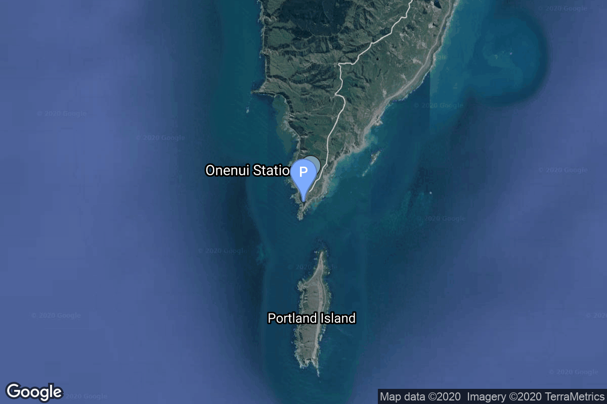
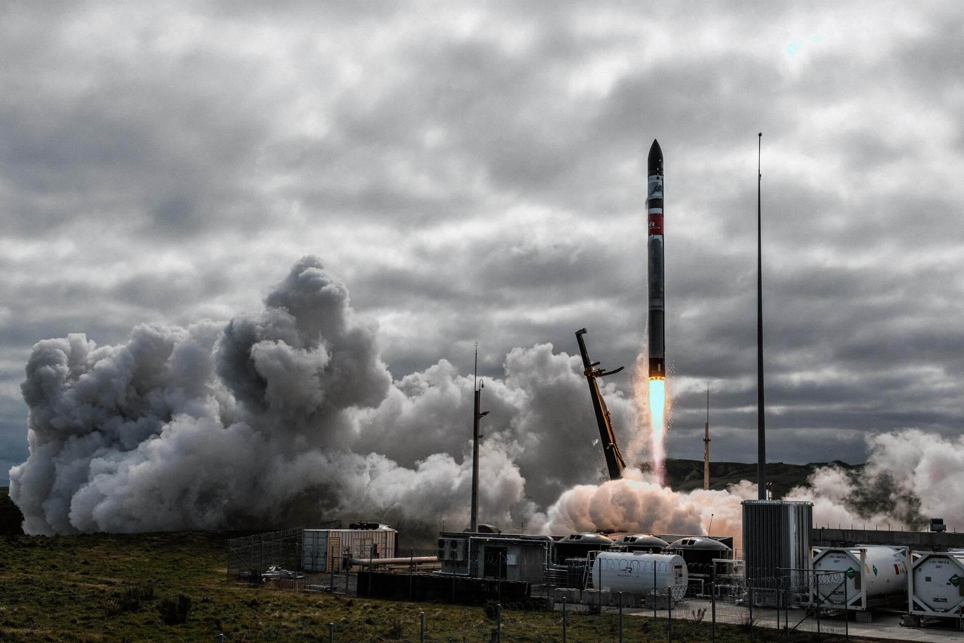
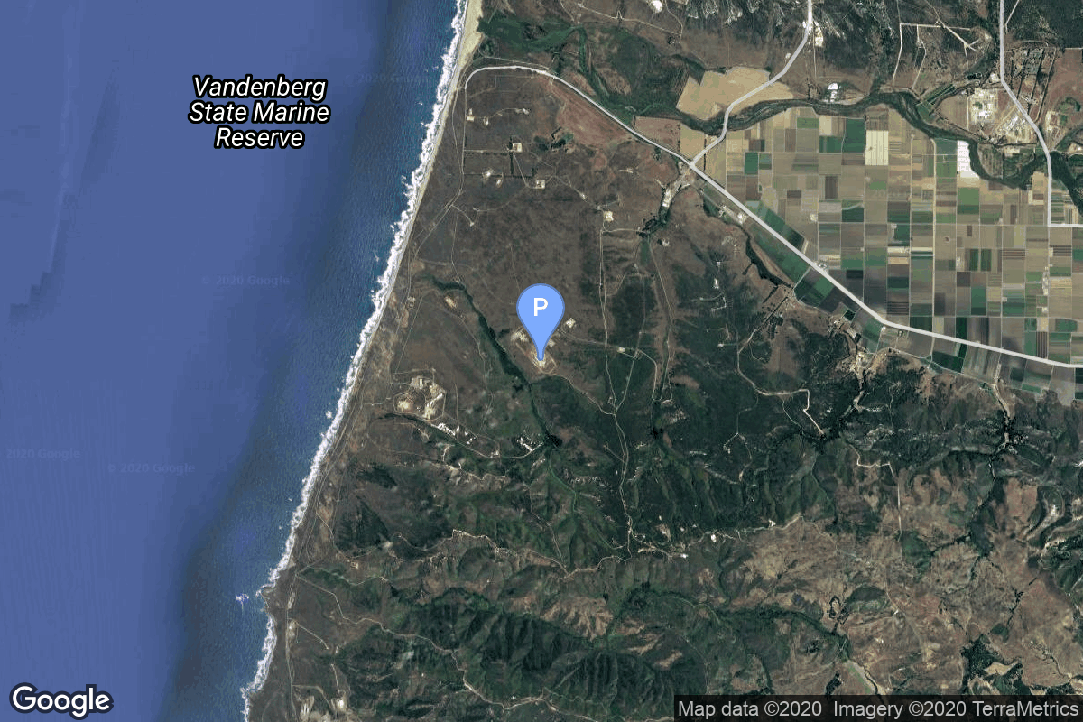
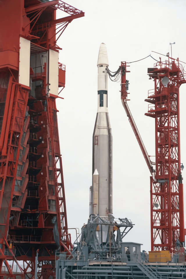
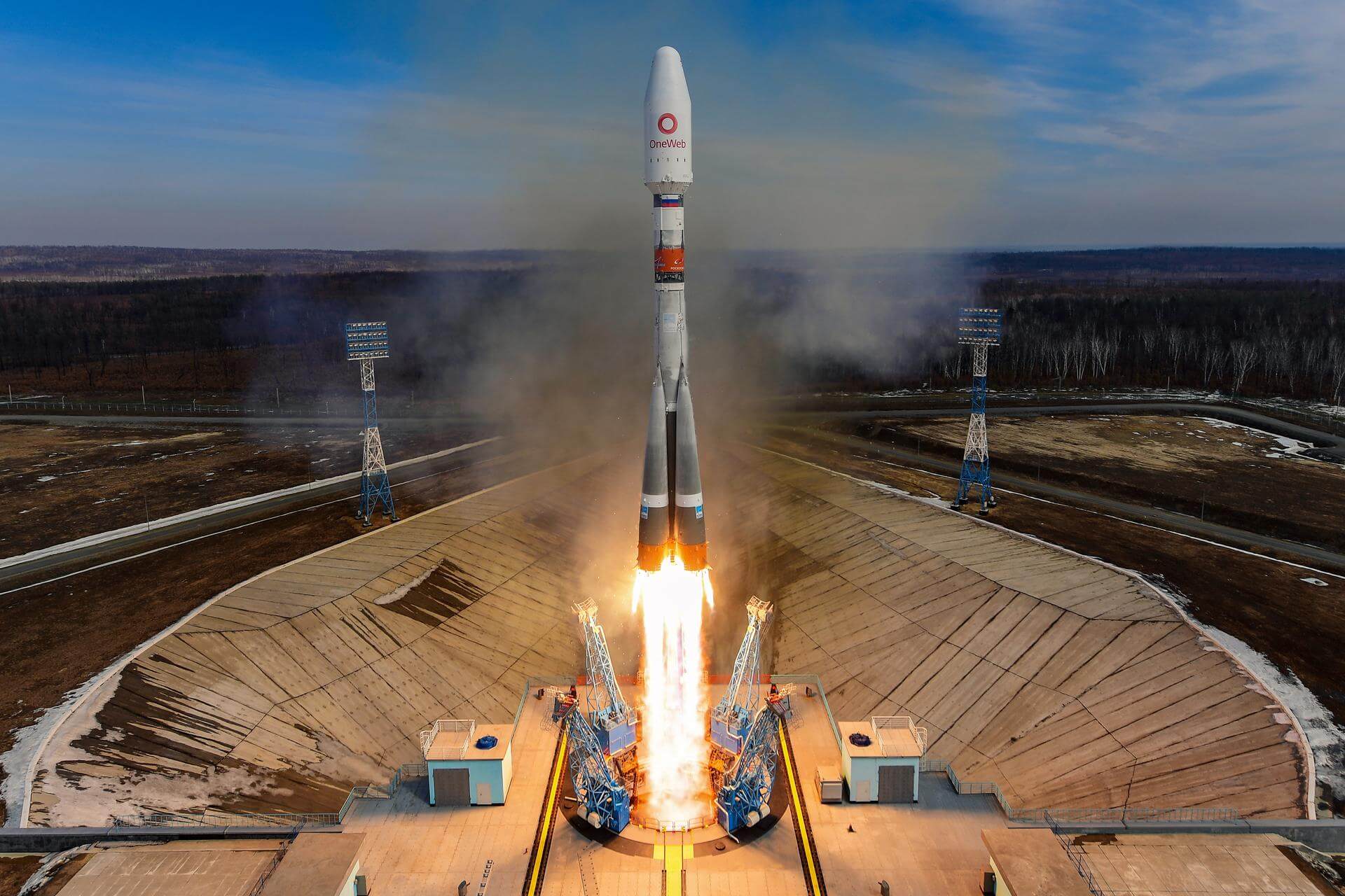
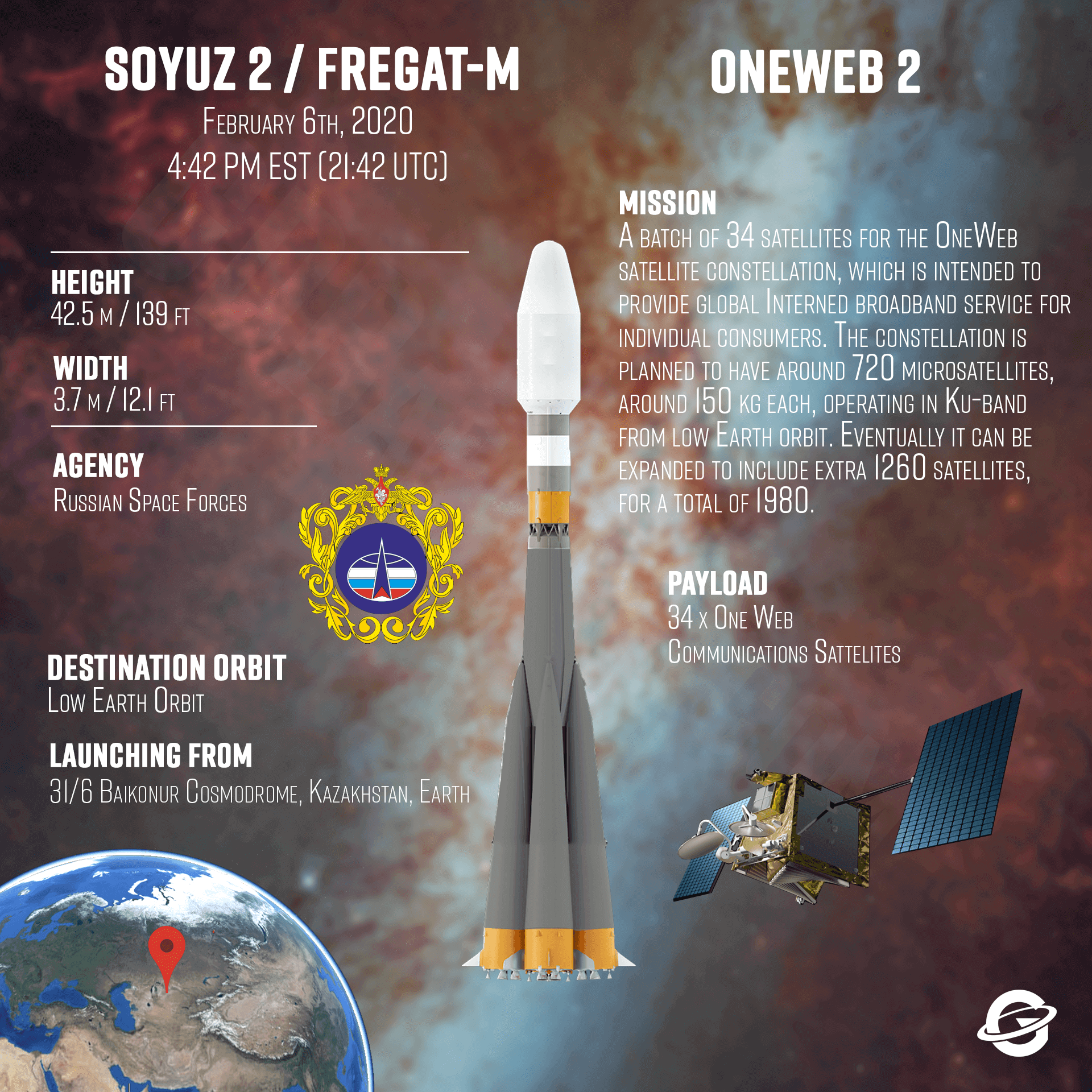
{ "count": 7937, "next": "https://ll.thespacedevs.com/2.2.0/launch/?format=api&limit=10&offset=4230&ordering=-id", "previous": "https://ll.thespacedevs.com/2.2.0/launch/?format=api&limit=10&offset=4210&ordering=-id", "results": [ { "id": "7975274c-81c5-48a5-82e1-9b8d982cd533", "url": "https://ll.thespacedevs.com/2.2.0/launch/7975274c-81c5-48a5-82e1-9b8d982cd533/?format=api", "slug": "electron-we-love-the-nightlife-capella-acadia-1", "name": "Electron | We Love the Nightlife (Capella Acadia 1)", "status": { "id": 3, "name": "Launch Successful", "abbrev": "Success", "description": "The launch vehicle successfully inserted its payload(s) into the target orbit(s)." }, "last_updated": "2024-03-05T18:16:14Z", "net": "2023-08-23T23:45:00Z", "window_end": "2023-08-24T03:30:00Z", "window_start": "2023-08-23T23:30:00Z", "net_precision": { "id": 1, "name": "Minute", "abbrev": "MIN", "description": "The T-0 is accurate to the minute." }, "probability": null, "weather_concerns": null, "holdreason": "", "failreason": "", "hashtag": null, "launch_service_provider": { "id": 147, "url": "https://ll.thespacedevs.com/2.2.0/agencies/147/?format=api", "name": "Rocket Lab", "type": "Commercial" }, "rocket": { "id": 7795, "configuration": { "id": 26, "url": "https://ll.thespacedevs.com/2.2.0/config/launcher/26/?format=api", "name": "Electron", "family": "", "full_name": "Electron", "variant": "" } }, "mission": { "id": 6313, "name": "We Love the Nightlife (Capella Acadia 1)", "description": "Payload consists of a single SAR Earth-imaging Acadia satellite, a new generation satellite designed, manufactured, and operated by Capella Space.\r\n\r\nFirst mission to fly with a reused engine.", "launch_designator": null, "type": "Earth Science", "orbit": { "id": 8, "name": "Low Earth Orbit", "abbrev": "LEO" }, "agencies": [ { "id": 1059, "url": "https://ll.thespacedevs.com/2.2.0/agencies/1059/?format=api", "name": "Capella Space", "featured": false, "type": "Private", "country_code": "USA", "abbrev": "", "description": "Capella Space is an American space company. It is developing space-based radar Earth observation satellites equipped with synthetic-aperture radar that can penetrate clouds and work at night.", "administrator": "CEO: Payam Banazadeh", "founding_year": "2016", "launchers": "", "spacecraft": "", "launch_library_url": null, "total_launch_count": 0, "consecutive_successful_launches": 0, "successful_launches": 0, "failed_launches": 0, "pending_launches": 0, "consecutive_successful_landings": 0, "successful_landings": 0, "failed_landings": 0, "attempted_landings": 0, "info_url": "https://capellaspace.com/", "wiki_url": "https://en.wikipedia.org/wiki/Capella_Space", "logo_url": "https://thespacedevs-prod.nyc3.digitaloceanspaces.com/media/images/capella2520space_logo_20230806180121.png", "image_url": null, "nation_url": null } ], "info_urls": [], "vid_urls": [] }, "pad": { "id": 185, "url": "https://ll.thespacedevs.com/2.2.0/pad/185/?format=api", "agency_id": 147, "name": "Rocket Lab Launch Complex 1B", "description": "", "info_url": null, "wiki_url": "https://en.wikipedia.org/wiki/Rocket_Lab_Launch_Complex_1", "map_url": "https://www.google.com/maps?q=-39.262833,177.864469", "latitude": "-39.262833", "longitude": "177.864469", "location": { "id": 10, "url": "https://ll.thespacedevs.com/2.2.0/location/10/?format=api", "name": "Rocket Lab Launch Complex 1, Mahia Peninsula, New Zealand", "country_code": "NZL", "description": "Rocket Lab Launch Complex 1 is a commercial spaceport located close to Ahuriri Point at the southern tip of Māhia Peninsula, on the east coast of New Zealand's North Island. It is owned and operated by private spaceflight company Rocket Lab and supports launches of the company's Electron rocket for small satellites. With the launch of Electron on 25 May 2017, it became the first private spaceport to host an orbital launch attempt, and the first site in New Zealand to host an orbital launch attempt. With the Electron launch of 21 January 2018, it became the first private spaceport to host a successful orbital launch.", "map_image": "https://thespacedevs-prod.nyc3.digitaloceanspaces.com/media/map_images/location_10_20200803142509.jpg", "timezone_name": "Pacific/Auckland", "total_launch_count": 78, "total_landing_count": 17 }, "country_code": "NZL", "map_image": "https://thespacedevs-prod.nyc3.digitaloceanspaces.com/media/map_images/pad_185_20200803143540.jpg", "total_launch_count": 37, "orbital_launch_attempt_count": 37 }, "webcast_live": false, "image": "https://thespacedevs-prod.nyc3.digitaloceanspaces.com/media/images/electron25202_image_20230824082352.jpeg", "infographic": null, "program": [], "orbital_launch_attempt_count": 6501, "location_launch_attempt_count": 37, "pad_launch_attempt_count": 11, "agency_launch_attempt_count": 40, "orbital_launch_attempt_count_year": 133, "location_launch_attempt_count_year": 5, "pad_launch_attempt_count_year": 5, "agency_launch_attempt_count_year": 8, "type": "normal" }, { "id": "796705f7-eece-4e77-9884-7ebf24135faa", "url": "https://ll.thespacedevs.com/2.2.0/launch/796705f7-eece-4e77-9884-7ebf24135faa/?format=api", "slug": "atlas-agena-b-midas-6", "name": "Atlas Agena B | Midas 6", "status": { "id": 4, "name": "Launch Failure", "abbrev": "Failure", "description": "Either the launch vehicle did not reach orbit, or the payload(s) failed to separate." }, "last_updated": "2023-06-14T03:42:26Z", "net": "1962-12-17T20:36:33Z", "window_end": "1962-12-17T20:36:33Z", "window_start": "1962-12-17T20:36:33Z", "net_precision": null, "probability": null, "weather_concerns": null, "holdreason": "", "failreason": null, "hashtag": null, "launch_service_provider": { "id": 161, "url": "https://ll.thespacedevs.com/2.2.0/agencies/161/?format=api", "name": "United States Air Force", "type": "Government" }, "rocket": { "id": 3178, "configuration": { "id": 183, "url": "https://ll.thespacedevs.com/2.2.0/config/launcher/183/?format=api", "name": "Atlas Agena B", "family": "Atlas", "full_name": "Atlas LV-3 Agena B", "variant": "LV-3 Agena B" } }, "mission": { "id": 1600, "name": "Midas 6", "description": "MIDAS Series 3 (Military Defense Alarm System) early warning satellite.", "launch_designator": null, "type": "Government/Top Secret", "orbit": { "id": 12, "name": "Medium Earth Orbit", "abbrev": "MEO" }, "agencies": [], "info_urls": [], "vid_urls": [] }, "pad": { "id": 24, "url": "https://ll.thespacedevs.com/2.2.0/pad/24/?format=api", "agency_id": 161, "name": "Space Launch Complex 3E", "description": "SLC-3E is a launch pad at Vandenberg Space Force Base. It was originally built for the MIDAS program and later used for various other missions. After a period of inactivity, it was refurbished in the early 2000s to launch Atlas V rockets. The pad is now being upgraded to accommodate the new Vulcan Centaur rocket. The last Atlas V launch from SLC-3E happened in November 2022, with the first Vulcan launch expected in 2025.", "info_url": null, "wiki_url": "https://en.wikipedia.org/wiki/Vandenberg_Space_Launch_Complex_3#SLC-3E", "map_url": "https://www.google.com/maps?q=34.64,-120.5895", "latitude": "34.64", "longitude": "-120.5895", "location": { "id": 11, "url": "https://ll.thespacedevs.com/2.2.0/location/11/?format=api", "name": "Vandenberg SFB, CA, USA", "country_code": "USA", "description": "Vandenberg Space Force Base is a United States Space Force Base in Santa Barbara County, California. Established in 1941, Vandenberg Space Force Base is a space launch base, launching spacecraft from the Western Range, and also performs missile testing. The United States Space Force's Space Launch Delta 30 serves as the host delta for the base, equivalent to an Air Force air base wing. In addition to its military space launch mission, Vandenberg Space Force Base also hosts space launches for civil and commercial space entities, such as NASA and SpaceX.", "map_image": "https://thespacedevs-prod.nyc3.digitaloceanspaces.com/media/map_images/location_11_20200803142416.jpg", "timezone_name": "America/Los_Angeles", "total_launch_count": 901, "total_landing_count": 35 }, "country_code": "USA", "map_image": "https://thespacedevs-prod.nyc3.digitaloceanspaces.com/media/map_images/pad_24_20200803143552.jpg", "total_launch_count": 48, "orbital_launch_attempt_count": 45 }, "webcast_live": false, "image": "https://thespacedevs-prod.nyc3.digitaloceanspaces.com/media/images/atlas-lv3_agena_image_20251111092848.png", "infographic": null, "program": [], "orbital_launch_attempt_count": 222, "location_launch_attempt_count": 81, "pad_launch_attempt_count": 6, "agency_launch_attempt_count": 125, "orbital_launch_attempt_count_year": 80, "location_launch_attempt_count_year": 37, "pad_launch_attempt_count_year": 3, "agency_launch_attempt_count_year": 54, "type": "normal" }, { "id": "79664d5f-03aa-4273-809b-92ba9e4a8b9c", "url": "https://ll.thespacedevs.com/2.2.0/launch/79664d5f-03aa-4273-809b-92ba9e4a8b9c/?format=api", "slug": "molniya-8k78-luna-5b", "name": "Molniya 8K78 | Luna-5b", "status": { "id": 4, "name": "Launch Failure", "abbrev": "Failure", "description": "Either the launch vehicle did not reach orbit, or the payload(s) failed to separate." }, "last_updated": "2023-06-14T03:48:24Z", "net": "1964-04-20T08:08:28Z", "window_end": "1964-04-20T08:08:28Z", "window_start": "1964-04-20T08:08:28Z", "net_precision": null, "probability": null, "weather_concerns": null, "holdreason": "", "failreason": null, "hashtag": null, "launch_service_provider": { "id": 66, "url": "https://ll.thespacedevs.com/2.2.0/agencies/66/?format=api", "name": "Soviet Space Program", "type": "Government" }, "rocket": { "id": 3273, "configuration": { "id": 184, "url": "https://ll.thespacedevs.com/2.2.0/config/launcher/184/?format=api", "name": "Molniya 8K78", "family": "R-7", "full_name": "Molniya 8K78", "variant": "8K78" } }, "mission": { "id": 1695, "name": "Luna-5b", "description": "Ye-6 series probe designed to land on the Moon. Failed to reach orbit.", "launch_designator": null, "type": "Lunar Exploration", "orbit": { "id": 11, "name": "Lunar Orbit", "abbrev": "LO" }, "agencies": [], "info_urls": [], "vid_urls": [] }, "pad": { "id": 32, "url": "https://ll.thespacedevs.com/2.2.0/pad/32/?format=api", "agency_id": null, "name": "1/5", "description": null, "info_url": null, "wiki_url": "", "map_url": "https://www.google.com/maps?q=45.92,63.342", "latitude": "45.92", "longitude": "63.342", "location": { "id": 15, "url": "https://ll.thespacedevs.com/2.2.0/location/15/?format=api", "name": "Baikonur Cosmodrome, Republic of Kazakhstan", "country_code": "KAZ", "description": "The Baikonur Cosmodrome is a spaceport operated by Russia within Kazakhstan. Located in the Kazakh city of Baikonur, it is the largest operational space launch facility in terms of area. All Russian crewed spaceflights are launched from Baikonur.", "map_image": "https://thespacedevs-prod.nyc3.digitaloceanspaces.com/media/map_images/location_15_20200803142517.jpg", "timezone_name": "Asia/Qyzylorda", "total_launch_count": 1564, "total_landing_count": 0 }, "country_code": "KAZ", "map_image": "https://thespacedevs-prod.nyc3.digitaloceanspaces.com/media/map_images/pad_32_20200803143513.jpg", "total_launch_count": 487, "orbital_launch_attempt_count": 487 }, "webcast_live": false, "image": "https://thespacedevs-prod.nyc3.digitaloceanspaces.com/media/images/molniya25208k78_image_20191201210000.jpg", "infographic": null, "program": [ { "id": 38, "url": "https://ll.thespacedevs.com/2.2.0/program/38/?format=api", "name": "Luna", "description": "The Luna program was a series of robotic spacecraft missions sent to the Moon by the Soviet Union between 1959 and 1976. The program accomplished many firsts in space exploration, including first flyby of the Moon, first impact of the Moon and first photos of the far side of the Moon. Each mission was designed as either an orbiter or lander. They also performed many experiments, studying the Moon's chemical composition, gravity, temperature, and radiation.", "agencies": [ { "id": 66, "url": "https://ll.thespacedevs.com/2.2.0/agencies/66/?format=api", "name": "Soviet Space Program", "type": "Government" } ], "image_url": "https://thespacedevs-prod.nyc3.digitaloceanspaces.com/media/images/luna_1_impactor_image_20240813082956.jpg", "start_date": "1958-09-23T07:40:23Z", "end_date": "1976-08-22T17:55:00Z", "info_url": null, "wiki_url": "https://en.wikipedia.org/wiki/Luna_programme", "mission_patches": [], "type": { "id": 5, "name": "Exploration" } } ], "orbital_launch_attempt_count": 317, "location_launch_attempt_count": 64, "pad_launch_attempt_count": 61, "agency_launch_attempt_count": 82, "orbital_launch_attempt_count_year": 24, "location_launch_attempt_count_year": 8, "pad_launch_attempt_count_year": 6, "agency_launch_attempt_count_year": 10, "type": "normal" }, { "id": "7964fba5-2ed4-4de2-bd25-b7ae983402c8", "url": "https://ll.thespacedevs.com/2.2.0/launch/7964fba5-2ed4-4de2-bd25-b7ae983402c8/?format=api", "slug": "proton-kdm-ekran-18", "name": "Proton-K/DM | Ekran", "status": { "id": 3, "name": "Launch Successful", "abbrev": "Success", "description": "The launch vehicle successfully inserted its payload(s) into the target orbit(s)." }, "last_updated": "2023-06-14T04:23:45Z", "net": "1985-03-22T05:00:00Z", "window_end": "1985-03-22T05:00:00Z", "window_start": "1985-03-22T05:00:00Z", "net_precision": null, "probability": null, "weather_concerns": null, "holdreason": "", "failreason": null, "hashtag": null, "launch_service_provider": { "id": 66, "url": "https://ll.thespacedevs.com/2.2.0/agencies/66/?format=api", "name": "Soviet Space Program", "type": "Government" }, "rocket": { "id": 5732, "configuration": { "id": 349, "url": "https://ll.thespacedevs.com/2.2.0/config/launcher/349/?format=api", "name": "Proton-K/DM", "family": "Proton / UR-500", "full_name": "Proton-K/DM", "variant": "DM" } }, "mission": { "id": 3186, "name": "Ekran", "description": "Ekran was a Soviet series of geostationary satellites which were the first in the world to provide Direct-To-Home TV service.", "launch_designator": null, "type": "Communications", "orbit": { "id": 1, "name": "Geostationary Orbit", "abbrev": "Direct-GEO" }, "agencies": [], "info_urls": [], "vid_urls": [] }, "pad": { "id": 130, "url": "https://ll.thespacedevs.com/2.2.0/pad/130/?format=api", "agency_id": null, "name": "200/40", "description": null, "info_url": null, "wiki_url": "https://en.wikipedia.org/wiki/Baikonur_Cosmodrome_Site_200", "map_url": "https://www.google.com/maps?q=46.0336111,63.0266949", "latitude": "46.0336111", "longitude": "63.0266949", "location": { "id": 15, "url": "https://ll.thespacedevs.com/2.2.0/location/15/?format=api", "name": "Baikonur Cosmodrome, Republic of Kazakhstan", "country_code": "KAZ", "description": "The Baikonur Cosmodrome is a spaceport operated by Russia within Kazakhstan. Located in the Kazakh city of Baikonur, it is the largest operational space launch facility in terms of area. All Russian crewed spaceflights are launched from Baikonur.", "map_image": "https://thespacedevs-prod.nyc3.digitaloceanspaces.com/media/map_images/location_15_20200803142517.jpg", "timezone_name": "Asia/Qyzylorda", "total_launch_count": 1564, "total_landing_count": 0 }, "country_code": "KAZ", "map_image": "https://thespacedevs-prod.nyc3.digitaloceanspaces.com/media/map_images/pad_130_20200803143249.jpg", "total_launch_count": 64, "orbital_launch_attempt_count": 64 }, "webcast_live": false, "image": "https://thespacedevs-prod.nyc3.digitaloceanspaces.com/media/images/proton_image_20231231095535.jpg", "infographic": null, "program": [], "orbital_launch_attempt_count": 2928, "location_launch_attempt_count": 734, "pad_launch_attempt_count": 35, "agency_launch_attempt_count": 1875, "orbital_launch_attempt_count_year": 24, "location_launch_attempt_count_year": 7, "pad_launch_attempt_count_year": 1, "agency_launch_attempt_count_year": 19, "type": "normal" }, { "id": "795cc32b-8a4f-47e4-9f4e-f3d3b24ddff5", "url": "https://ll.thespacedevs.com/2.2.0/launch/795cc32b-8a4f-47e4-9f4e-f3d3b24ddff5/?format=api", "slug": "long-march-2c-shijian-11-06", "name": "Long March 2C | Shijian 11-06", "status": { "id": 3, "name": "Launch Successful", "abbrev": "Success", "description": "The launch vehicle successfully inserted its payload(s) into the target orbit(s)." }, "last_updated": "2023-06-14T15:48:07Z", "net": "2014-03-31T02:46:03Z", "window_end": "2014-03-31T02:46:03Z", "window_start": "2014-03-31T02:46:03Z", "net_precision": null, "probability": null, "weather_concerns": null, "holdreason": "", "failreason": null, "hashtag": null, "launch_service_provider": { "id": 88, "url": "https://ll.thespacedevs.com/2.2.0/agencies/88/?format=api", "name": "China Aerospace Science and Technology Corporation", "type": "Government" }, "rocket": { "id": 1744, "configuration": { "id": 61, "url": "https://ll.thespacedevs.com/2.2.0/config/launcher/61/?format=api", "name": "Long March 2C", "family": "Long March", "full_name": "Long March 2C", "variant": "C" } }, "mission": null, "pad": { "id": 22, "url": "https://ll.thespacedevs.com/2.2.0/pad/22/?format=api", "agency_id": null, "name": "Launch Area 94 (SLS-2 / 603)", "description": "", "info_url": null, "wiki_url": "https://en.wikipedia.org/wiki/Jiuquan_Launch_Area_4", "map_url": "https://www.google.com/maps?q=40.960482,100.298059", "latitude": "40.960482", "longitude": "100.298059", "location": { "id": 17, "url": "https://ll.thespacedevs.com/2.2.0/location/17/?format=api", "name": "Jiuquan Satellite Launch Center, People's Republic of China", "country_code": "CHN", "description": "Jiuquan Satellite Launch Center is a Chinese spaceport located between the Ejin, Alxa, Inner Mongolia and Hangtian Town, Jinta County, Jiuquan, Gansu Province. It is part of the Dongfeng Aerospace City (Base 10).", "map_image": "https://thespacedevs-prod.nyc3.digitaloceanspaces.com/media/map_images/location_17_20200803142429.jpg", "timezone_name": "Asia/Shanghai", "total_launch_count": 292, "total_landing_count": 2 }, "country_code": "CHN", "map_image": "https://thespacedevs-prod.nyc3.digitaloceanspaces.com/media/map_images/pad_22_20200803143437.jpg", "total_launch_count": 137, "orbital_launch_attempt_count": 137 }, "webcast_live": false, "image": "https://thespacedevs-prod.nyc3.digitaloceanspaces.com/media/images/long_march_2_image_20230803100234.jpeg", "infographic": null, "program": [], "orbital_launch_attempt_count": 5363, "location_launch_attempt_count": 70, "pad_launch_attempt_count": 30, "agency_launch_attempt_count": 135, "orbital_launch_attempt_count_year": 14, "location_launch_attempt_count_year": 1, "pad_launch_attempt_count_year": 1, "agency_launch_attempt_count_year": 1, "type": "normal" }, { "id": "795b501c-fc9d-42eb-bdae-96d616172494", "url": "https://ll.thespacedevs.com/2.2.0/launch/795b501c-fc9d-42eb-bdae-96d616172494/?format=api", "slug": "thor-delta-e1-isis-1", "name": "Thor Delta E1 | Isis 1", "status": { "id": 3, "name": "Launch Successful", "abbrev": "Success", "description": "The launch vehicle successfully inserted its payload(s) into the target orbit(s)." }, "last_updated": "2023-06-14T04:18:58Z", "net": "1969-01-30T06:46:00Z", "window_end": "1969-01-30T06:46:00Z", "window_start": "1969-01-30T06:46:00Z", "net_precision": null, "probability": null, "weather_concerns": null, "holdreason": "", "failreason": null, "hashtag": null, "launch_service_provider": { "id": 161, "url": "https://ll.thespacedevs.com/2.2.0/agencies/161/?format=api", "name": "United States Air Force", "type": "Government" }, "rocket": { "id": 3868, "configuration": { "id": 405, "url": "https://ll.thespacedevs.com/2.2.0/config/launcher/405/?format=api", "name": "Thor Delta E1", "family": "Thor", "full_name": "Thor Delta E1", "variant": "Delta E1" } }, "mission": { "id": 2286, "name": "Isis 1", "description": "ISIS 1 (International Satellite for Ionosphere Studies) was an ionospheric observatory instrumented with sweep- and fixed-frequency ionosondes, a VLF receiver, energetic and soft particle detectors, an ion mass spectrometer, an electrostatic probe, an electrostatic analyzer, a beacon transmitter, and a cosmic noise experiment.", "launch_designator": null, "type": "Earth Science", "orbit": { "id": 0, "name": "Elliptical Orbit", "abbrev": "Elliptical" }, "agencies": [], "info_urls": [], "vid_urls": [] }, "pad": { "id": 98, "url": "https://ll.thespacedevs.com/2.2.0/pad/98/?format=api", "agency_id": 161, "name": "Space Launch Complex 2E", "description": "SLC-2E, was used for Delta, Thor-Agena and Thorad launches between 1966 and 1972 and has been demolished", "info_url": null, "wiki_url": "https://en.wikipedia.org/wiki/Vandenberg_Space_Launch_Complex_2", "map_url": "https://www.google.com/maps?q=34.7516,-120.6192", "latitude": "34.7516", "longitude": "-120.6192", "location": { "id": 11, "url": "https://ll.thespacedevs.com/2.2.0/location/11/?format=api", "name": "Vandenberg SFB, CA, USA", "country_code": "USA", "description": "Vandenberg Space Force Base is a United States Space Force Base in Santa Barbara County, California. Established in 1941, Vandenberg Space Force Base is a space launch base, launching spacecraft from the Western Range, and also performs missile testing. The United States Space Force's Space Launch Delta 30 serves as the host delta for the base, equivalent to an Air Force air base wing. In addition to its military space launch mission, Vandenberg Space Force Base also hosts space launches for civil and commercial space entities, such as NASA and SpaceX.", "map_image": "https://thespacedevs-prod.nyc3.digitaloceanspaces.com/media/map_images/location_11_20200803142416.jpg", "timezone_name": "America/Los_Angeles", "total_launch_count": 901, "total_landing_count": 35 }, "country_code": "USA", "map_image": "https://thespacedevs-prod.nyc3.digitaloceanspaces.com/media/map_images/pad_98_20200803143228.jpg", "total_launch_count": 47, "orbital_launch_attempt_count": 47 }, "webcast_live": false, "image": "https://thespacedevs-prod.nyc3.digitaloceanspaces.com/media/images/delta-e1_2528i_image_20251205042339.png", "infographic": null, "program": [], "orbital_launch_attempt_count": 930, "location_launch_attempt_count": 319, "pad_launch_attempt_count": 39, "agency_launch_attempt_count": 477, "orbital_launch_attempt_count_year": 11, "location_launch_attempt_count_year": 2, "pad_launch_attempt_count_year": 1, "agency_launch_attempt_count_year": 3, "type": "normal" }, { "id": "79556b71-ae2d-4cfe-b4e1-76e02359bc26", "url": "https://ll.thespacedevs.com/2.2.0/launch/79556b71-ae2d-4cfe-b4e1-76e02359bc26/?format=api", "slug": "long-march-11-shiyan-24c", "name": "Long March 11 | Shiyan 24C", "status": { "id": 3, "name": "Launch Successful", "abbrev": "Success", "description": "The launch vehicle successfully inserted its payload(s) into the target orbit(s)." }, "last_updated": "2024-03-05T17:38:34Z", "net": "2023-12-25T22:39:00Z", "window_end": "2023-12-25T23:05:00Z", "window_start": "2023-12-25T22:20:00Z", "net_precision": { "id": 1, "name": "Minute", "abbrev": "MIN", "description": "The T-0 is accurate to the minute." }, "probability": null, "weather_concerns": null, "holdreason": "", "failreason": "", "hashtag": null, "launch_service_provider": { "id": 88, "url": "https://ll.thespacedevs.com/2.2.0/agencies/88/?format=api", "name": "China Aerospace Science and Technology Corporation", "type": "Government" }, "rocket": { "id": 8151, "configuration": { "id": 47, "url": "https://ll.thespacedevs.com/2.2.0/config/launcher/47/?format=api", "name": "Long March 11", "family": "Long March", "full_name": "Long March 11", "variant": "" } }, "mission": { "id": 6712, "name": "Shiyan 24C", "description": "3 satellites of unknown testing purposes, officially referred as for \"orbital technology testing\".", "launch_designator": null, "type": "Government/Top Secret", "orbit": { "id": 17, "name": "Sun-Synchronous Orbit", "abbrev": "SSO" }, "agencies": [], "info_urls": [], "vid_urls": [] }, "pad": { "id": 217, "url": "https://ll.thespacedevs.com/2.2.0/pad/217/?format=api", "agency_id": 88, "name": "South China Sea (launch location 1)", "description": "", "info_url": null, "wiki_url": null, "map_url": "https://www.google.com/maps?q=21.283333,112.0", "latitude": "21.283333", "longitude": "112.0", "location": { "id": 185, "url": "https://ll.thespacedevs.com/2.2.0/location/185/?format=api", "name": "Haiyang Oriental Spaceport", "country_code": "CHN", "description": "Chinese orbital launch vehicle launches supporting sea port located at Haiyang, Shandong Province, with dedicated piers and rocket/payload processing facilities for Chinese launch vehicles’ sea launches, and (as part of its expansion project) land based launch pads on artificial islands for various test vehicles and launch vehicles of private and government launch services providers.\r\n\r\nIn operation as a remote base of Taiyuan Satellite Launch Center since 2019.", "map_image": "https://thespacedevs-prod.nyc3.digitaloceanspaces.com/media/map_images/location_haiyang_oriental_spaceport_20251128181322.jpg", "timezone_name": "Asia/Shanghai", "total_launch_count": 26, "total_landing_count": 0 }, "country_code": "CHN", "map_image": "https://thespacedevs-prod.nyc3.digitaloceanspaces.com/media/map_images/pad_bo_run_jiu_zhou_mobile_launch_platform_20231206001303.jpg", "total_launch_count": 2, "orbital_launch_attempt_count": 2 }, "webcast_live": false, "image": "https://thespacedevs-prod.nyc3.digitaloceanspaces.com/media/images/long2520march_image_20231226095919.jpeg", "infographic": null, "program": [], "orbital_launch_attempt_count": 6583, "location_launch_attempt_count": 8, "pad_launch_attempt_count": 2, "agency_launch_attempt_count": 450, "orbital_launch_attempt_count_year": 215, "location_launch_attempt_count_year": 3, "pad_launch_attempt_count_year": 2, "agency_launch_attempt_count_year": 45, "type": "normal" }, { "id": "79477a4a-055d-460a-9bdc-b3b58a8ac3ca", "url": "https://ll.thespacedevs.com/2.2.0/launch/79477a4a-055d-460a-9bdc-b3b58a8ac3ca/?format=api", "slug": "soyuz-21bfregat-m-oneweb-2", "name": "Soyuz 2.1b/Fregat-M | OneWeb 2", "status": { "id": 3, "name": "Launch Successful", "abbrev": "Success", "description": "The launch vehicle successfully inserted its payload(s) into the target orbit(s)." }, "last_updated": "2024-10-13T18:03:11Z", "net": "2020-02-06T21:42:41Z", "window_end": "2020-02-06T21:42:41Z", "window_start": "2020-02-06T21:42:41Z", "net_precision": null, "probability": null, "weather_concerns": null, "holdreason": "", "failreason": "", "hashtag": null, "launch_service_provider": { "id": 115, "url": "https://ll.thespacedevs.com/2.2.0/agencies/115/?format=api", "name": "Arianespace", "type": "Commercial" }, "rocket": { "id": 2599, "configuration": { "id": 134, "url": "https://ll.thespacedevs.com/2.2.0/config/launcher/134/?format=api", "name": "Soyuz 2.1b/Fregat-M", "family": "Soyuz", "full_name": "Soyuz 2.1b Fregat-M", "variant": "Fregat-M" } }, "mission": { "id": 1080, "name": "OneWeb 2", "description": "A batch of 34 satellites for the OneWeb satellite constellation, which is intended to provide global Internet broadband service for individual consumers. The constellation is planned to have around 648 microsatellites (of which 60 are spares), around 150 kg each, operating in Ku-band from low Earth orbit. Eventually it can be expanded to include extra 1260 satellites, for a total of 1908.", "launch_designator": null, "type": "Communications", "orbit": { "id": 13, "name": "Polar Orbit", "abbrev": "PO" }, "agencies": [], "info_urls": [], "vid_urls": [] }, "pad": { "id": 20, "url": "https://ll.thespacedevs.com/2.2.0/pad/20/?format=api", "agency_id": null, "name": "31/6", "description": "", "info_url": null, "wiki_url": "https://en.wikipedia.org/wiki/Baikonur_Cosmodrome_Site_31", "map_url": "https://www.google.com/maps?q=45.996034,63.564003", "latitude": "45.996034", "longitude": "63.564003", "location": { "id": 15, "url": "https://ll.thespacedevs.com/2.2.0/location/15/?format=api", "name": "Baikonur Cosmodrome, Republic of Kazakhstan", "country_code": "KAZ", "description": "The Baikonur Cosmodrome is a spaceport operated by Russia within Kazakhstan. Located in the Kazakh city of Baikonur, it is the largest operational space launch facility in terms of area. All Russian crewed spaceflights are launched from Baikonur.", "map_image": "https://thespacedevs-prod.nyc3.digitaloceanspaces.com/media/map_images/location_15_20200803142517.jpg", "timezone_name": "Asia/Qyzylorda", "total_launch_count": 1564, "total_landing_count": 0 }, "country_code": "KAZ", "map_image": "https://thespacedevs-prod.nyc3.digitaloceanspaces.com/media/map_images/pad_20_20200803143516.jpg", "total_launch_count": 429, "orbital_launch_attempt_count": 429 }, "webcast_live": false, "image": "https://thespacedevs-prod.nyc3.digitaloceanspaces.com/media/images/soyuz25202.1b_image_20210520085936.jpeg", "infographic": "https://thespacedevs-prod.nyc3.digitaloceanspaces.com/media/infographic_images/soyuz25202.1b_infographic_20200807035203.png", "program": [ { "id": 26, "url": "https://ll.thespacedevs.com/2.2.0/program/26/?format=api", "name": "OneWeb", "description": "Satellite constellation in low Earth orbit that can provide high-speed broadband internet to rural and isolated areas.", "agencies": [ { "id": 1081, "url": "https://ll.thespacedevs.com/2.2.0/agencies/1081/?format=api", "name": "Eutelsat OneWeb", "type": "Commercial" } ], "image_url": "https://thespacedevs-prod.nyc3.digitaloceanspaces.com/media/images/oneweb_program_20231228155842.jpeg", "start_date": "2019-02-27T21:37:00Z", "end_date": null, "info_url": "https://oneweb.net/", "wiki_url": "https://en.wikipedia.org/wiki/Eutelsat_OneWeb", "mission_patches": [], "type": { "id": 3, "name": "Communication Constellation" } } ], "orbital_launch_attempt_count": 5930, "location_launch_attempt_count": 1509, "pad_launch_attempt_count": 382, "agency_launch_attempt_count": 284, "orbital_launch_attempt_count_year": 8, "location_launch_attempt_count_year": 1, "pad_launch_attempt_count_year": 1, "agency_launch_attempt_count_year": 2, "type": "normal" }, { "id": "79457385-acb8-427a-a577-ade80ddd450b", "url": "https://ll.thespacedevs.com/2.2.0/launch/79457385-acb8-427a-a577-ade80ddd450b/?format=api", "slug": "thor-delta-m-intelsat-iii-f-3", "name": "Thor Delta M | INTELSAT III F-3", "status": { "id": 3, "name": "Launch Successful", "abbrev": "Success", "description": "The launch vehicle successfully inserted its payload(s) into the target orbit(s)." }, "last_updated": "2023-06-14T17:40:18Z", "net": "1969-02-06T00:39:00Z", "window_end": "1969-02-06T00:39:00Z", "window_start": "1969-02-06T00:39:00Z", "net_precision": null, "probability": null, "weather_concerns": null, "holdreason": "", "failreason": null, "hashtag": null, "launch_service_provider": { "id": 161, "url": "https://ll.thespacedevs.com/2.2.0/agencies/161/?format=api", "name": "United States Air Force", "type": "Government" }, "rocket": { "id": 3871, "configuration": { "id": 409, "url": "https://ll.thespacedevs.com/2.2.0/config/launcher/409/?format=api", "name": "Thor Delta M", "family": "Thor", "full_name": "Thor Delta M", "variant": "Delta M" } }, "mission": { "id": 2289, "name": "INTELSAT III F-3", "description": "The Intelsat 3 spacecraft were used to relay commercial global telecommunications including live TV. Three of the 8 satellites in the series (F1, F5, F8) were unusable due to launch vehicle failures, and most of the remainder did not achieve their desired lifetimes.", "launch_designator": null, "type": "Communications", "orbit": { "id": 1, "name": "Geostationary Orbit", "abbrev": "Direct-GEO" }, "agencies": [], "info_urls": [], "vid_urls": [] }, "pad": { "id": 14, "url": "https://ll.thespacedevs.com/2.2.0/pad/14/?format=api", "agency_id": null, "name": "Space Launch Complex 17A", "description": "", "info_url": null, "wiki_url": "https://en.wikipedia.org/wiki/Cape_Canaveral_Space_Launch_Complex_17", "map_url": "https://www.google.com/maps?q=28.4472,-80.565", "latitude": "28.4472", "longitude": "-80.565", "location": { "id": 12, "url": "https://ll.thespacedevs.com/2.2.0/location/12/?format=api", "name": "Cape Canaveral SFS, FL, USA", "country_code": "USA", "description": "Cape Canaveral Space Force Station (CCSFS) is an installation of the United States Space Force's Space Launch Delta 45, located on Cape Canaveral in Brevard County, Florida.", "map_image": "https://thespacedevs-prod.nyc3.digitaloceanspaces.com/media/map_images/location_12_20200803142519.jpg", "timezone_name": "America/New_York", "total_launch_count": 1122, "total_landing_count": 75 }, "country_code": "USA", "map_image": "https://thespacedevs-prod.nyc3.digitaloceanspaces.com/media/map_images/pad_14_20200803143451.jpg", "total_launch_count": 145, "orbital_launch_attempt_count": 145 }, "webcast_live": false, "image": "https://thespacedevs-prod.nyc3.digitaloceanspaces.com/media/images/thor_delta_m_image_20251122093853.jpg", "infographic": null, "program": [], "orbital_launch_attempt_count": 933, "location_launch_attempt_count": 229, "pad_launch_attempt_count": 38, "agency_launch_attempt_count": 479, "orbital_launch_attempt_count_year": 14, "location_launch_attempt_count_year": 2, "pad_launch_attempt_count_year": 1, "agency_launch_attempt_count_year": 5, "type": "normal" }, { "id": "793c9a86-b242-417c-893a-790222a28fc7", "url": "https://ll.thespacedevs.com/2.2.0/launch/793c9a86-b242-417c-893a-790222a28fc7/?format=api", "slug": "vega-c-sbg-tir", "name": "Vega-C | SBG-TIR", "status": { "id": 2, "name": "To Be Determined", "abbrev": "TBD", "description": "Current date is a placeholder or rough estimation based on unreliable or interpreted sources." }, "last_updated": "2025-02-13T10:44:01Z", "net": "2029-12-31T00:00:00Z", "window_end": "2029-12-31T00:00:00Z", "window_start": "2029-12-31T00:00:00Z", "net_precision": { "id": 14, "name": "Year", "abbrev": "Y", "description": "The T-0 is expected in the given year." }, "probability": null, "weather_concerns": null, "holdreason": "", "failreason": "", "hashtag": null, "launch_service_provider": { "id": 159, "url": "https://ll.thespacedevs.com/2.2.0/agencies/159/?format=api", "name": "Avio S.p.A", "type": "Commercial" }, "rocket": { "id": 8525, "configuration": { "id": 127, "url": "https://ll.thespacedevs.com/2.2.0/config/launcher/127/?format=api", "name": "Vega-C", "family": "Vega", "full_name": "Vega-C", "variant": "" } }, "mission": { "id": 7115, "name": "SBG-TIR", "description": "The Surface Biology and Geology - Thermal Infrared (SBG-TIR) Earth Observation mission aims to provide radiometric and multispectral measurements of terrestrial and aquatic emissions for climate, ecological, and geological analyses, and to support practical applications such as food security and water management. The thermal infrared (TIR) radiometer is provided by NASA, while the VIS-NIR camera is provided by ASI. Their combination ensures high-quality observations, enabling the investigation of terrestrial and marine ecosystems, monitoring of water resources, and phenomena related to high temperatures such as wildfires and volcanic eruptions.", "launch_designator": null, "type": "Earth Science", "orbit": { "id": 17, "name": "Sun-Synchronous Orbit", "abbrev": "SSO" }, "agencies": [ { "id": 36, "url": "https://ll.thespacedevs.com/2.2.0/agencies/36/?format=api", "name": "Italian Space Agency", "featured": false, "type": "Government", "country_code": "ITA", "abbrev": "ASI", "description": null, "administrator": null, "founding_year": null, "launchers": "", "spacecraft": "", "launch_library_url": null, "total_launch_count": 3, "consecutive_successful_launches": 3, "successful_launches": 3, "failed_launches": 0, "pending_launches": 0, "consecutive_successful_landings": 0, "successful_landings": 0, "failed_landings": 0, "attempted_landings": 0, "info_url": "https://www.asi.it/", "wiki_url": "https://en.wikipedia.org/wiki/Italian_Space_Agency", "logo_url": null, "image_url": null, "nation_url": null }, { "id": 44, "url": "https://ll.thespacedevs.com/2.2.0/agencies/44/?format=api", "name": "National Aeronautics and Space Administration", "featured": true, "type": "Government", "country_code": "USA", "abbrev": "NASA", "description": "The National Aeronautics and Space Administration is an independent agency of the executive branch of the United States federal government responsible for the civilian space program, as well as aeronautics and aerospace research. NASA have many launch facilities but most are inactive. The most commonly used pad will be LC-39B at Kennedy Space Center in Florida.", "administrator": "Administrator: Jared Isaacman", "founding_year": "1958", "launchers": "Space Shuttle | SLS", "spacecraft": "Orion", "launch_library_url": null, "total_launch_count": 142, "consecutive_successful_launches": 12, "successful_launches": 122, "failed_launches": 20, "pending_launches": 5, "consecutive_successful_landings": 0, "successful_landings": 0, "failed_landings": 0, "attempted_landings": 0, "info_url": "https://www.nasa.gov", "wiki_url": "https://en.wikipedia.org/wiki/National_Aeronautics_and_Space_Administration", "logo_url": "https://thespacedevs-prod.nyc3.digitaloceanspaces.com/media/images/national2520aeronautics2520and2520space2520administration_logo_20190207032448.png", "image_url": "https://thespacedevs-prod.nyc3.digitaloceanspaces.com/media/images/national2520aeronautics2520and2520space2520administration_image_20190207032448.jpeg", "nation_url": "https://thespacedevs-prod.nyc3.digitaloceanspaces.com/media/images/national2520aeronautics2520and2520space2520administration_nation_20230803040809.jpg" } ], "info_urls": [], "vid_urls": [] }, "pad": { "id": 34, "url": "https://ll.thespacedevs.com/2.2.0/pad/34/?format=api", "agency_id": 115, "name": "Ariane Launch Area 1 (ELV)", "description": "ELA-1, now named Ensemble de Lancement Vega (short ELV), is a launch pad at the Centre Spatial Guyanais in French Guiana. It has been used to support launches of the Europa rocket, Ariane 1, Ariane 3, and is currently used to launch Vega rockets.", "info_url": null, "wiki_url": "https://en.wikipedia.org/wiki/ELA-1", "map_url": "https://www.google.com/maps?q=5.236,-52.775", "latitude": "5.236", "longitude": "-52.775", "location": { "id": 13, "url": "https://ll.thespacedevs.com/2.2.0/location/13/?format=api", "name": "Guiana Space Centre, French Guiana", "country_code": "GUF", "description": "The Guiana Space Centre is a European spaceport to the northwest of Kourou in French Guiana, a region of France in South America. Kourou is located at a latitude of 5°. In operation since 1968, it is a suitable location for a spaceport because of its equatorial location and open sea to the east.", "map_image": "https://thespacedevs-prod.nyc3.digitaloceanspaces.com/media/map_images/location_13_20200803142412.jpg", "timezone_name": "America/Cayenne", "total_launch_count": 334, "total_landing_count": 0 }, "country_code": "GUF", "map_image": "https://thespacedevs-prod.nyc3.digitaloceanspaces.com/media/map_images/pad_34_20200803143527.jpg", "total_launch_count": 55, "orbital_launch_attempt_count": 55 }, "webcast_live": false, "image": "https://thespacedevs-prod.nyc3.digitaloceanspaces.com/media/images/vega-c_image_20220713154437.jpg", "infographic": null, "program": [], "orbital_launch_attempt_count": 7690, "location_launch_attempt_count": 378, "pad_launch_attempt_count": 76, "agency_launch_attempt_count": 23, "orbital_launch_attempt_count_year": 44, "location_launch_attempt_count_year": 8, "pad_launch_attempt_count_year": 3, "agency_launch_attempt_count_year": 3, "type": "normal" } ] }