Launch List
AN API endpoint that returns all Launch objects or a single launch.
EXAMPLE - /launch/[id]/ or /launch/?mode=list&search=SpaceX
GET Return a list of all Launch objects.
FILTERS Fields - 'name', 'id(s)', 'lsp__id', 'lsp__name', 'serial_number', 'launcher_config__id', 'rocket__spacecraftflight__spacecraft__name', 'is_crewed', 'include_suborbital', 'spacecraft_config__ids', 'related', 'location__ids', 'lsp__ids', 'pad__ids', 'status__ids'
MODE 'normal', 'list', 'detailed'
EXAMPLE ?mode=list
SEARCH Searches through the launch name, rocket name, launch agency, mission name & spacecraft name.
EXAMPLE - ?search=SpaceX
GET /2.2.0/launch/?format=api&offset=3700&ordering=-id
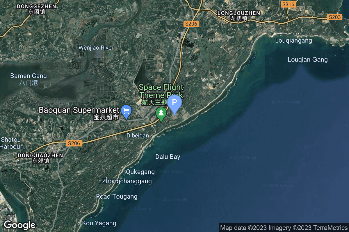
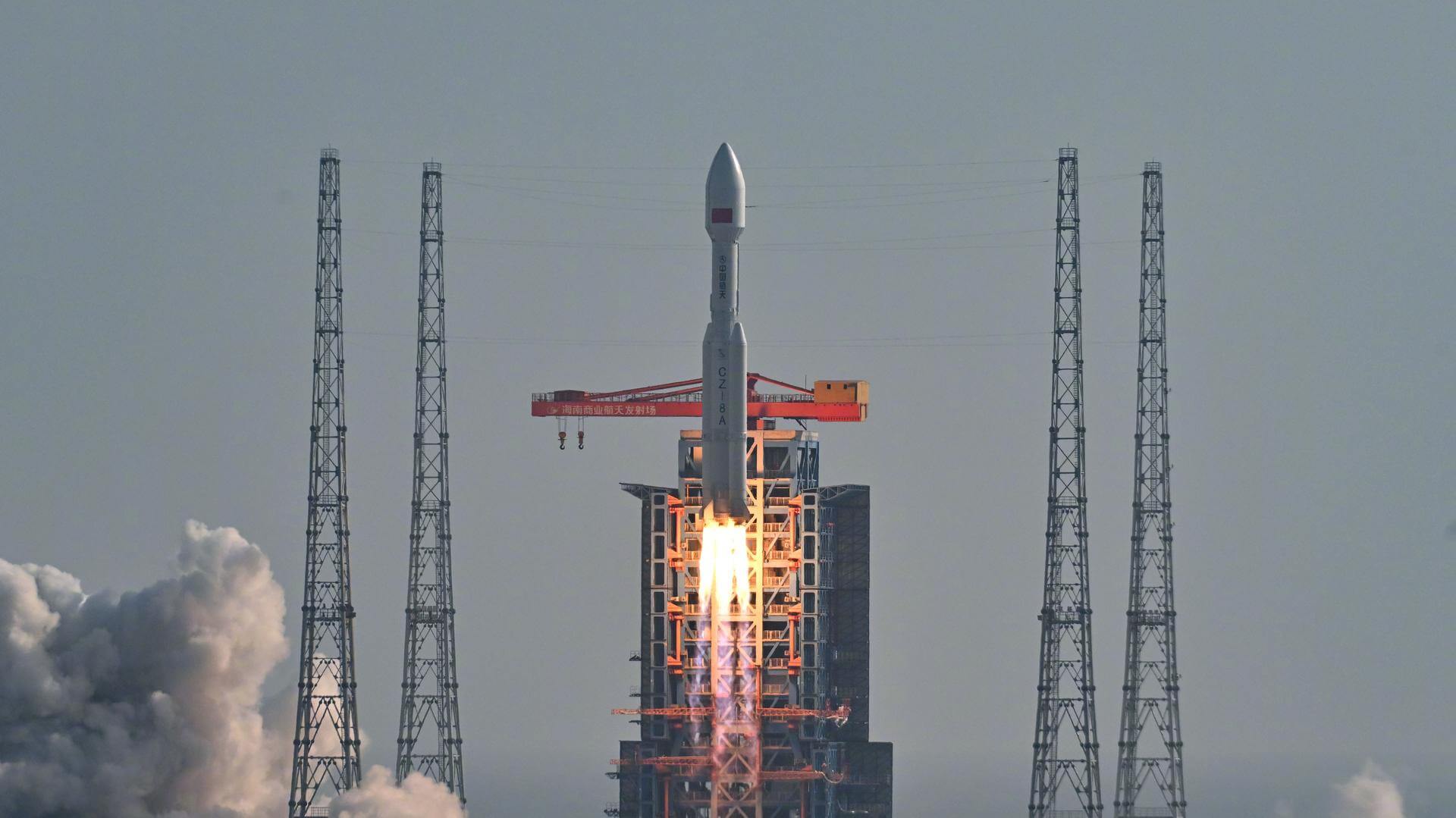
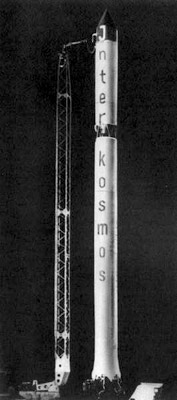
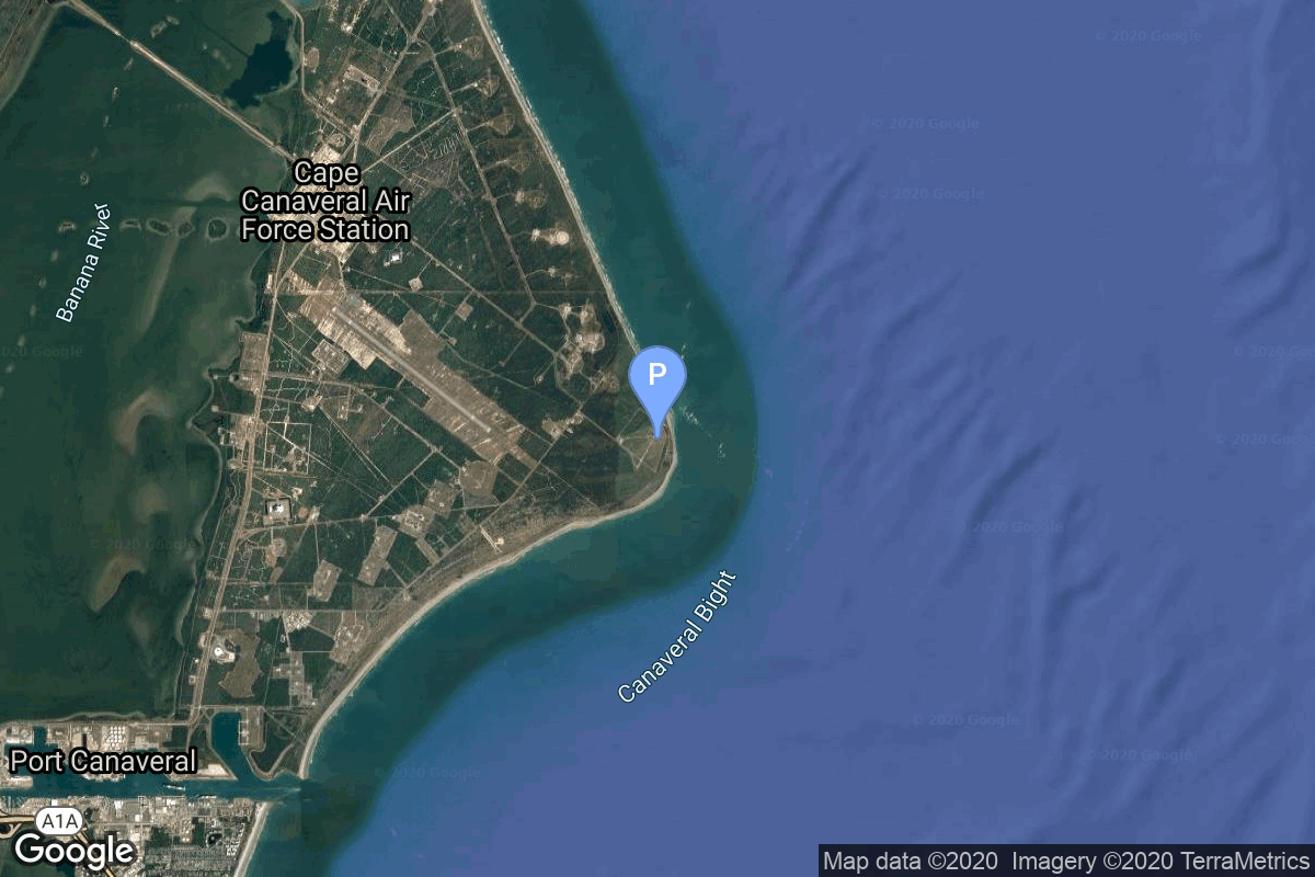
{ "count": 7920, "next": "https://ll.thespacedevs.com/2.2.0/launch/?format=api&limit=10&offset=3710&ordering=-id", "previous": "https://ll.thespacedevs.com/2.2.0/launch/?format=api&limit=10&offset=3690&ordering=-id", "results": [ { "id": "888e0de3-ce4d-4daf-8140-bb0d3a4c8245", "url": "https://ll.thespacedevs.com/2.2.0/launch/888e0de3-ce4d-4daf-8140-bb0d3a4c8245/?format=api", "slug": "long-march-8a-spacesail-polar-group-tbd", "name": "Long March 8A | SpaceSail Polar Group TBD", "status": { "id": 1, "name": "Go for Launch", "abbrev": "Go", "description": "Current T-0 confirmed by official or reliable sources." }, "last_updated": "2026-07-03T12:26:49Z", "net": "2026-07-05T13:40:00Z", "window_end": "2026-07-05T13:57:00Z", "window_start": "2026-07-05T13:32:00Z", "net_precision": { "id": 2, "name": "Hour", "abbrev": "HR", "description": "The T-0 is accurate to the hour." }, "probability": null, "weather_concerns": null, "holdreason": "", "failreason": "", "hashtag": null, "launch_service_provider": { "id": 88, "url": "https://ll.thespacedevs.com/2.2.0/agencies/88/?format=api", "name": "China Aerospace Science and Technology Corporation", "type": "Government" }, "rocket": { "id": 9078, "configuration": { "id": 518, "url": "https://ll.thespacedevs.com/2.2.0/config/launcher/518/?format=api", "name": "Long March 8A", "family": "Long March", "full_name": "Long March 8A", "variant": "A" } }, "mission": { "id": 7673, "name": "SpaceSail Polar Group TBD", "description": "Low Earth Orbit communication satellites with Ku, Q and V band payloads for the G60 constellation operated by Shanghai Spacesail Technologies with funding backed by the Shanghai local government.\r\n\r\nInitial constellation will consist of 1296 satellites by 2027 with long term plans to expand it to 12000 satellites.", "launch_designator": null, "type": "Communications", "orbit": { "id": 13, "name": "Polar Orbit", "abbrev": "PO" }, "agencies": [], "info_urls": [], "vid_urls": [] }, "pad": { "id": 218, "url": "https://ll.thespacedevs.com/2.2.0/pad/218/?format=api", "agency_id": null, "name": "Commercial LC-1", "description": "", "info_url": null, "wiki_url": "https://en.wikipedia.org/wiki/Wenchang_Commercial_Space_Launch_Site", "map_url": "https://www.google.com/maps?q=19.597275,110.930753", "latitude": "19.597275", "longitude": "110.930753", "location": { "id": 8, "url": "https://ll.thespacedevs.com/2.2.0/location/8/?format=api", "name": "Wenchang Space Launch Site, People's Republic of China", "country_code": "CHN", "description": "The Wenchang Space Launch Site is a rocket launch site located in Wenchang on the island of Hainan, in China.\r\n\r\nFormally a suborbital test center, it currently serves as China's southernmost spaceport. The site was selected for its low latitude, 19° north of the equator, allowing for larger payloads to be launched. It is capable of launching the Long March 5, the heaviest Chinese rocket. Unlike launch facilities on the mainland, Wenchang uses its seaport for deliveries.", "map_image": "https://thespacedevs-prod.nyc3.digitaloceanspaces.com/media/map_images/location_8_20200803142445.jpg", "timezone_name": "Asia/Shanghai", "total_launch_count": 66, "total_landing_count": 0 }, "country_code": "CHN", "map_image": "https://thespacedevs-prod.nyc3.digitaloceanspaces.com/media/map_images/pad_commercial_lc-1_20231225074041.jpg", "total_launch_count": 11, "orbital_launch_attempt_count": 11 }, "webcast_live": false, "image": "https://thespacedevs-prod.nyc3.digitaloceanspaces.com/media/images/cz-8a_launch_2_image_20251206093107.jpeg", "infographic": null, "program": [], "orbital_launch_attempt_count": 7334, "location_launch_attempt_count": 67, "pad_launch_attempt_count": 12, "agency_launch_attempt_count": 603, "orbital_launch_attempt_count_year": 161, "location_launch_attempt_count_year": 12, "pad_launch_attempt_count_year": 6, "agency_launch_attempt_count_year": 33, "type": "normal" }, { "id": "8885fb90-baee-4c96-8745-1ec7da77cc2d", "url": "https://ll.thespacedevs.com/2.2.0/launch/8885fb90-baee-4c96-8745-1ec7da77cc2d/?format=api", "slug": "kosmos-11k63-ds-p1-yu-71", "name": "Kosmos 11K63 | DS-P1-Yu 71", "status": { "id": 3, "name": "Launch Successful", "abbrev": "Success", "description": "The launch vehicle successfully inserted its payload(s) into the target orbit(s)." }, "last_updated": "2023-06-14T03:31:44Z", "net": "1974-07-25T12:06:00Z", "window_end": "1974-07-25T12:06:00Z", "window_start": "1974-07-25T12:06:00Z", "net_precision": null, "probability": null, "weather_concerns": null, "holdreason": "", "failreason": null, "hashtag": null, "launch_service_provider": { "id": 66, "url": "https://ll.thespacedevs.com/2.2.0/agencies/66/?format=api", "name": "Soviet Space Program", "type": "Government" }, "rocket": { "id": 4495, "configuration": { "id": 327, "url": "https://ll.thespacedevs.com/2.2.0/config/launcher/327/?format=api", "name": "Kosmos 11K63", "family": "Kosmos", "full_name": "Kosmos 11K63", "variant": "11K63" } }, "mission": { "id": 2913, "name": "DS-P1-Yu 71", "description": "The DS-P1-Yu series of satellites was used to calibrate space surveillance and early warning radars.", "launch_designator": null, "type": "Test Target", "orbit": { "id": 8, "name": "Low Earth Orbit", "abbrev": "LEO" }, "agencies": [], "info_urls": [], "vid_urls": [] }, "pad": { "id": 3, "url": "https://ll.thespacedevs.com/2.2.0/pad/3/?format=api", "agency_id": 163, "name": "133/3 (133L)", "description": null, "info_url": null, "wiki_url": "", "map_url": "https://www.google.com/maps?q=62.886999,40.846984", "latitude": "62.886999", "longitude": "40.846984", "location": { "id": 6, "url": "https://ll.thespacedevs.com/2.2.0/location/6/?format=api", "name": "Plesetsk Cosmodrome, Russian Federation", "country_code": "RUS", "description": "Plesetsk Cosmodrome is a Russian spaceport located in Mirny, Arkhangelsk Oblast, about 800 km north of Moscow and approximately 200 km south of Arkhangelsk. Originally developed as an ICBM site for the R-7 missile, it also served for numerous satellite launches using the R-7 and other rockets. Its high latitude makes it useful only for certain types of launches, especially the Molniya orbits, so for much of the site's history it functioned as a secondary location, with most orbital launches taking place from Baikonur, in the Kazakh SSR. With the end of the Soviet Union, Baikonur became a foreign territory, and Kazakhstan charged $115 million usage fees annually. Consequently, Plesetsk has seen considerably more activity since the 2000s.", "map_image": "https://thespacedevs-prod.nyc3.digitaloceanspaces.com/media/map_images/location_6_20200803142434.jpg", "timezone_name": "Europe/Moscow", "total_launch_count": 1685, "total_landing_count": 0 }, "country_code": "RUS", "map_image": "https://thespacedevs-prod.nyc3.digitaloceanspaces.com/media/map_images/pad_3_20200803143438.jpg", "total_launch_count": 159, "orbital_launch_attempt_count": 159 }, "webcast_live": false, "image": "https://thespacedevs-prod.nyc3.digitaloceanspaces.com/media/images/kosmos_11k63_image_20251104091702.jpg", "infographic": null, "program": [], "orbital_launch_attempt_count": 1601, "location_launch_attempt_count": 369, "pad_launch_attempt_count": 77, "agency_launch_attempt_count": 848, "orbital_launch_attempt_count_year": 63, "location_launch_attempt_count_year": 32, "pad_launch_attempt_count_year": 5, "agency_launch_attempt_count_year": 47, "type": "normal" }, { "id": "887ed4ee-f7f0-4316-ac5c-d89f3844914b", "url": "https://ll.thespacedevs.com/2.2.0/launch/887ed4ee-f7f0-4316-ac5c-d89f3844914b/?format=api", "slug": "falcon-9-block-5-telesat-lightspeed-14", "name": "Falcon 9 Block 5 | Telesat Lightspeed 14", "status": { "id": 2, "name": "To Be Determined", "abbrev": "TBD", "description": "Current date is a placeholder or rough estimation based on unreliable or interpreted sources." }, "last_updated": "2023-09-11T12:47:52Z", "net": "2027-12-31T00:00:00Z", "window_end": "2027-12-31T00:00:00Z", "window_start": "2027-12-31T00:00:00Z", "net_precision": { "id": 14, "name": "Year", "abbrev": "Y", "description": "The T-0 is expected in the given year." }, "probability": null, "weather_concerns": null, "holdreason": "", "failreason": "", "hashtag": null, "launch_service_provider": { "id": 121, "url": "https://ll.thespacedevs.com/2.2.0/agencies/121/?format=api", "name": "SpaceX", "type": "Commercial" }, "rocket": { "id": 8017, "configuration": { "id": 164, "url": "https://ll.thespacedevs.com/2.2.0/config/launcher/164/?format=api", "name": "Falcon 9", "family": "Falcon", "full_name": "Falcon 9 Block 5", "variant": "Block 5" } }, "mission": { "id": 6553, "name": "Telesat Lightspeed 14", "description": "Up to 18 satellites manufactured by MDA for Canadian satellite operator Telesat's Lightspeed constellation.", "launch_designator": null, "type": "Communications", "orbit": { "id": 8, "name": "Low Earth Orbit", "abbrev": "LEO" }, "agencies": [ { "id": 208, "url": "https://ll.thespacedevs.com/2.2.0/agencies/208/?format=api", "name": "Telesat", "featured": false, "type": "Commercial", "country_code": "CAN", "abbrev": "TELE", "description": "Telesat, formerly Telesat Canada, is a Canadian satellite communications company founded on May 2, 1969.", "administrator": null, "founding_year": null, "launchers": "", "spacecraft": "", "launch_library_url": null, "total_launch_count": 0, "consecutive_successful_launches": 0, "successful_launches": 0, "failed_launches": 0, "pending_launches": 0, "consecutive_successful_landings": 0, "successful_landings": 0, "failed_landings": 0, "attempted_landings": 0, "info_url": "https://www.telesat.com/", "wiki_url": "https://en.wikipedia.org/wiki/Telesat", "logo_url": null, "image_url": null, "nation_url": null } ], "info_urls": [], "vid_urls": [] }, "pad": { "id": 72, "url": "https://ll.thespacedevs.com/2.2.0/pad/72/?format=api", "agency_id": null, "name": "Unknown Pad", "description": null, "info_url": null, "wiki_url": "", "map_url": "https://www.google.com/maps?q=28.458,-80.528", "latitude": "28.458", "longitude": "-80.528", "location": { "id": 12, "url": "https://ll.thespacedevs.com/2.2.0/location/12/?format=api", "name": "Cape Canaveral SFS, FL, USA", "country_code": "USA", "description": "Cape Canaveral Space Force Station (CCSFS) is an installation of the United States Space Force's Space Launch Delta 45, located on Cape Canaveral in Brevard County, Florida.", "map_image": "https://thespacedevs-prod.nyc3.digitaloceanspaces.com/media/map_images/location_12_20200803142519.jpg", "timezone_name": "America/New_York", "total_launch_count": 1118, "total_landing_count": 75 }, "country_code": "USA", "map_image": "https://thespacedevs-prod.nyc3.digitaloceanspaces.com/media/map_images/pad_72_20200803143403.jpg", "total_launch_count": 0, "orbital_launch_attempt_count": 0 }, "webcast_live": false, "image": "https://thespacedevs-prod.nyc3.digitaloceanspaces.com/media/images/falcon_9_image_20230807133459.jpeg", "infographic": null, "program": [], "orbital_launch_attempt_count": 7591, "location_launch_attempt_count": 1209, "pad_launch_attempt_count": 52, "agency_launch_attempt_count": 800, "orbital_launch_attempt_count_year": 95, "location_launch_attempt_count_year": 39, "pad_launch_attempt_count_year": 28, "agency_launch_attempt_count_year": 44, "type": "normal" }, { "id": "887eb3dc-ead1-4fef-87a1-b490e780f43a", "url": "https://ll.thespacedevs.com/2.2.0/launch/887eb3dc-ead1-4fef-87a1-b490e780f43a/?format=api", "slug": "falcon-9-block-5-starlink-group-17-23", "name": "Falcon 9 Block 5 | Starlink Group 17-23", "status": { "id": 3, "name": "Launch Successful", "abbrev": "Success", "description": "The launch vehicle successfully inserted its payload(s) into the target orbit(s)." }, "last_updated": "2026-03-02T04:13:32Z", "net": "2026-03-01T10:10:39Z", "window_end": "2026-03-01T12:00:00Z", "window_start": "2026-03-01T08:00:00Z", "net_precision": { "id": 0, "name": "Second", "abbrev": "SEC", "description": "The T-0 is accurate to the second." }, "probability": null, "weather_concerns": null, "holdreason": "", "failreason": "", "hashtag": null, "launch_service_provider": { "id": 121, "url": "https://ll.thespacedevs.com/2.2.0/agencies/121/?format=api", "name": "SpaceX", "type": "Commercial" }, "rocket": { "id": 8915, "configuration": { "id": 164, "url": "https://ll.thespacedevs.com/2.2.0/config/launcher/164/?format=api", "name": "Falcon 9", "family": "Falcon", "full_name": "Falcon 9 Block 5", "variant": "Block 5" } }, "mission": { "id": 7507, "name": "Starlink Group 17-23", "description": "A batch of 25 satellites for the Starlink mega-constellation - SpaceX's project for space-based Internet communication system.", "launch_designator": null, "type": "Communications", "orbit": { "id": 8, "name": "Low Earth Orbit", "abbrev": "LEO" }, "agencies": [ { "id": 121, "url": "https://ll.thespacedevs.com/2.2.0/agencies/121/?format=api", "name": "SpaceX", "featured": true, "type": "Commercial", "country_code": "USA", "abbrev": "SpX", "description": "Space Exploration Technologies Corp., known as SpaceX, is an American aerospace manufacturer and space transport services company headquartered in Hawthorne, California. It was founded in 2002 by entrepreneur Elon Musk with the goal of reducing space transportation costs and enabling the colonization of Mars. SpaceX operates from many pads, on the East Coast of the US they operate from SLC-40 at Cape Canaveral Space Force Station and historic LC-39A at Kennedy Space Center. They also operate from SLC-4E at Vandenberg Space Force Base, California, usually for polar launches. Another launch site is being developed at Boca Chica, Texas.", "administrator": "CEO: Elon Musk", "founding_year": "2002", "launchers": "Falcon | Starship", "spacecraft": "Dragon", "launch_library_url": null, "total_launch_count": 698, "consecutive_successful_launches": 183, "successful_launches": 683, "failed_launches": 15, "pending_launches": 131, "consecutive_successful_landings": 19, "successful_landings": 643, "failed_landings": 28, "attempted_landings": 670, "info_url": "https://www.spacex.com/", "wiki_url": "https://en.wikipedia.org/wiki/SpaceX", "logo_url": "https://thespacedevs-prod.nyc3.digitaloceanspaces.com/media/images/spacex_logo_20220826094919.png", "image_url": "https://thespacedevs-prod.nyc3.digitaloceanspaces.com/media/images/falcon_9_image_20230807133459.jpeg", "nation_url": "https://thespacedevs-prod.nyc3.digitaloceanspaces.com/media/images/spacex_social_l_image_20260407054626.jpg" } ], "info_urls": [], "vid_urls": [] }, "pad": { "id": 16, "url": "https://ll.thespacedevs.com/2.2.0/pad/16/?format=api", "agency_id": null, "name": "Space Launch Complex 4E", "description": "Space Launch Complex 4 East (SLC-4E) is a launch site at Vandenberg Space Force Base, California, U.S.\r\n\r\nThe pad was previously used by Atlas and Titan rockets between 1963 and 2005. The pad was built for use by Atlas-Agena rockets, but was later rebuilt to handle Titan rockets.", "info_url": null, "wiki_url": "https://en.wikipedia.org/wiki/Vandenberg_Space_Launch_Complex_4#SLC-4E", "map_url": "https://www.google.com/maps?q=34.632,-120.611", "latitude": "34.632", "longitude": "-120.611", "location": { "id": 11, "url": "https://ll.thespacedevs.com/2.2.0/location/11/?format=api", "name": "Vandenberg SFB, CA, USA", "country_code": "USA", "description": "Vandenberg Space Force Base is a United States Space Force Base in Santa Barbara County, California. Established in 1941, Vandenberg Space Force Base is a space launch base, launching spacecraft from the Western Range, and also performs missile testing. The United States Space Force's Space Launch Delta 30 serves as the host delta for the base, equivalent to an Air Force air base wing. In addition to its military space launch mission, Vandenberg Space Force Base also hosts space launches for civil and commercial space entities, such as NASA and SpaceX.", "map_image": "https://thespacedevs-prod.nyc3.digitaloceanspaces.com/media/map_images/location_11_20200803142416.jpg", "timezone_name": "America/Los_Angeles", "total_launch_count": 895, "total_landing_count": 35 }, "country_code": "USA", "map_image": "https://thespacedevs-prod.nyc3.digitaloceanspaces.com/media/map_images/pad_16_20200803143532.jpg", "total_launch_count": 279, "orbital_launch_attempt_count": 279 }, "webcast_live": false, "image": "https://thespacedevs-prod.nyc3.digitaloceanspaces.com/media/images/falcon2520925_image_20221009234147.png", "infographic": null, "program": [ { "id": 25, "url": "https://ll.thespacedevs.com/2.2.0/program/25/?format=api", "name": "Starlink", "description": "Starlink is a satellite internet constellation operated by American aerospace company SpaceX", "agencies": [ { "id": 121, "url": "https://ll.thespacedevs.com/2.2.0/agencies/121/?format=api", "name": "SpaceX", "type": "Commercial" } ], "image_url": "https://thespacedevs-prod.nyc3.digitaloceanspaces.com/media/images/starlink_program_20231228154508.jpeg", "start_date": "2018-02-22T14:17:00Z", "end_date": null, "info_url": "https://starlink.com", "wiki_url": "https://en.wikipedia.org/wiki/Starlink", "mission_patches": [ { "id": 7, "name": "Space X Starlink Mission Patch", "priority": 10, "image_url": "https://thespacedevs-prod.nyc3.digitaloceanspaces.com/media/mission_patch_images/space2520x252_mission_patch_20221011205756.png", "agency": { "id": 121, "url": "https://ll.thespacedevs.com/2.2.0/agencies/121/?format=api", "name": "SpaceX", "type": "Commercial" } } ], "type": { "id": 3, "name": "Communication Constellation" } } ], "orbital_launch_attempt_count": 7216, "location_launch_attempt_count": 865, "pad_launch_attempt_count": 251, "agency_launch_attempt_count": 645, "orbital_launch_attempt_count_year": 43, "location_launch_attempt_count_year": 13, "pad_launch_attempt_count_year": 13, "agency_launch_attempt_count_year": 26, "type": "normal" }, { "id": "886be0c8-ed57-4522-a7d5-7d9ae7d71ec0", "url": "https://ll.thespacedevs.com/2.2.0/launch/886be0c8-ed57-4522-a7d5-7d9ae7d71ec0/?format=api", "slug": "titan-iiib-kh-8-12", "name": "Titan IIIB | KH-8 12", "status": { "id": 3, "name": "Launch Successful", "abbrev": "Success", "description": "The launch vehicle successfully inserted its payload(s) into the target orbit(s)." }, "last_updated": "2023-06-14T04:26:27Z", "net": "1968-03-13T19:51:00Z", "window_end": "1968-03-13T19:51:00Z", "window_start": "1968-03-13T19:51:00Z", "net_precision": null, "probability": null, "weather_concerns": null, "holdreason": "", "failreason": null, "hashtag": null, "launch_service_provider": { "id": 161, "url": "https://ll.thespacedevs.com/2.2.0/agencies/161/?format=api", "name": "United States Air Force", "type": "Government" }, "rocket": { "id": 3760, "configuration": { "id": 438, "url": "https://ll.thespacedevs.com/2.2.0/config/launcher/438/?format=api", "name": "Titan IIIB", "family": "Titan", "full_name": "Titan IIIB", "variant": "IIIB" } }, "mission": { "id": 2178, "name": "KH-8 12", "description": "KH-8 or Gambit-3 was the second generation of Gambit high resolution reconnaissance satellites.", "launch_designator": null, "type": "Government/Top Secret", "orbit": { "id": 8, "name": "Low Earth Orbit", "abbrev": "LEO" }, "agencies": [], "info_urls": [], "vid_urls": [] }, "pad": { "id": 156, "url": "https://ll.thespacedevs.com/2.2.0/pad/156/?format=api", "agency_id": null, "name": "Space Launch Complex 4W", "description": "SLC-4W started operations in 1963 as Space Launch Complex 4W, and continued as an operational launch site through 2003. In 2015, SpaceX started conversion of the launch site into Landing Zone LZ-4. Landing operations commenced in 2018 at LZ-4.", "info_url": "https://www.astronautix.com/v/vandenbergslc4w.html", "wiki_url": "https://en.wikipedia.org/wiki/Vandenberg_Air_Force_Base_Space_Launch_Complex_4#SLC-4W", "map_url": "https://www.google.com/maps?q=34.63312,-120.61584", "latitude": "34.63312", "longitude": "-120.61584", "location": { "id": 11, "url": "https://ll.thespacedevs.com/2.2.0/location/11/?format=api", "name": "Vandenberg SFB, CA, USA", "country_code": "USA", "description": "Vandenberg Space Force Base is a United States Space Force Base in Santa Barbara County, California. Established in 1941, Vandenberg Space Force Base is a space launch base, launching spacecraft from the Western Range, and also performs missile testing. The United States Space Force's Space Launch Delta 30 serves as the host delta for the base, equivalent to an Air Force air base wing. In addition to its military space launch mission, Vandenberg Space Force Base also hosts space launches for civil and commercial space entities, such as NASA and SpaceX.", "map_image": "https://thespacedevs-prod.nyc3.digitaloceanspaces.com/media/map_images/location_11_20200803142416.jpg", "timezone_name": "America/Los_Angeles", "total_launch_count": 895, "total_landing_count": 35 }, "country_code": "USA", "map_image": "https://thespacedevs-prod.nyc3.digitaloceanspaces.com/media/map_images/pad_156_20200803143351.jpg", "total_launch_count": 93, "orbital_launch_attempt_count": 93 }, "webcast_live": false, "image": "https://thespacedevs-prod.nyc3.digitaloceanspaces.com/media/images/titan_iiib_image_20251204210122.jpg", "infographic": null, "program": [], "orbital_launch_attempt_count": 808, "location_launch_attempt_count": 291, "pad_launch_attempt_count": 24, "agency_launch_attempt_count": 441, "orbital_launch_attempt_count_year": 20, "location_launch_attempt_count_year": 6, "pad_launch_attempt_count_year": 2, "agency_launch_attempt_count_year": 8, "type": "normal" }, { "id": "88696e88-4d1e-4efe-9027-5f1d65cfcd04", "url": "https://ll.thespacedevs.com/2.2.0/launch/88696e88-4d1e-4efe-9027-5f1d65cfcd04/?format=api", "slug": "molniya-m-molniya-1k-53", "name": "Molniya-M | Molniya-1K 53", "status": { "id": 3, "name": "Launch Successful", "abbrev": "Success", "description": "The launch vehicle successfully inserted its payload(s) into the target orbit(s)." }, "last_updated": "2023-06-14T04:29:24Z", "net": "1982-02-26T20:10:00Z", "window_end": "1982-02-26T20:10:00Z", "window_start": "1982-02-26T20:10:00Z", "net_precision": null, "probability": null, "weather_concerns": null, "holdreason": "", "failreason": null, "hashtag": null, "launch_service_provider": { "id": 66, "url": "https://ll.thespacedevs.com/2.2.0/agencies/66/?format=api", "name": "Soviet Space Program", "type": "Government" }, "rocket": { "id": 5369, "configuration": { "id": 106, "url": "https://ll.thespacedevs.com/2.2.0/config/launcher/106/?format=api", "name": "Molniya-M", "family": "R-7", "full_name": "Molniya-M 2BL", "variant": "2BL" } }, "mission": { "id": 3776, "name": "Molniya-1K 53", "description": "Military communications satellite in a highly elliptic orbit", "launch_designator": null, "type": "Government/Top Secret", "orbit": { "id": 0, "name": "Elliptical Orbit", "abbrev": "Elliptical" }, "agencies": [], "info_urls": [], "vid_urls": [] }, "pad": { "id": 168, "url": "https://ll.thespacedevs.com/2.2.0/pad/168/?format=api", "agency_id": null, "name": "41/1", "description": null, "info_url": null, "wiki_url": "https://en.wikipedia.org/wiki/Plesetsk_Cosmodrome", "map_url": "https://www.google.com/maps?q=62.941,40.526806", "latitude": "62.941", "longitude": "40.526806", "location": { "id": 6, "url": "https://ll.thespacedevs.com/2.2.0/location/6/?format=api", "name": "Plesetsk Cosmodrome, Russian Federation", "country_code": "RUS", "description": "Plesetsk Cosmodrome is a Russian spaceport located in Mirny, Arkhangelsk Oblast, about 800 km north of Moscow and approximately 200 km south of Arkhangelsk. Originally developed as an ICBM site for the R-7 missile, it also served for numerous satellite launches using the R-7 and other rockets. Its high latitude makes it useful only for certain types of launches, especially the Molniya orbits, so for much of the site's history it functioned as a secondary location, with most orbital launches taking place from Baikonur, in the Kazakh SSR. With the end of the Soviet Union, Baikonur became a foreign territory, and Kazakhstan charged $115 million usage fees annually. Consequently, Plesetsk has seen considerably more activity since the 2000s.", "map_image": "https://thespacedevs-prod.nyc3.digitaloceanspaces.com/media/map_images/location_6_20200803142434.jpg", "timezone_name": "Europe/Moscow", "total_launch_count": 1685, "total_landing_count": 0 }, "country_code": "RUS", "map_image": "https://thespacedevs-prod.nyc3.digitaloceanspaces.com/media/map_images/pad_168_20200803143446.jpg", "total_launch_count": 310, "orbital_launch_attempt_count": 310 }, "webcast_live": false, "image": "https://thespacedevs-prod.nyc3.digitaloceanspaces.com/media/images/molniya_m_image_20251102061752.jpg", "infographic": null, "program": [], "orbital_launch_attempt_count": 2532, "location_launch_attempt_count": 856, "pad_launch_attempt_count": 216, "agency_launch_attempt_count": 1563, "orbital_launch_attempt_count_year": 15, "location_launch_attempt_count_year": 9, "pad_launch_attempt_count_year": 3, "agency_launch_attempt_count_year": 12, "type": "normal" }, { "id": "88675d6b-d504-4aa6-9175-69a8610a40dd", "url": "https://ll.thespacedevs.com/2.2.0/launch/88675d6b-d504-4aa6-9175-69a8610a40dd/?format=api", "slug": "falcon-9-block-5-nrol-192", "name": "Falcon 9 Block 5 | NROL-192", "status": { "id": 3, "name": "Launch Successful", "abbrev": "Success", "description": "The launch vehicle successfully inserted its payload(s) into the target orbit(s)." }, "last_updated": "2025-04-13T05:51:16Z", "net": "2025-04-12T12:25:00Z", "window_end": "2025-04-12T16:46:00Z", "window_start": "2025-04-12T12:17:00Z", "net_precision": { "id": 1, "name": "Minute", "abbrev": "MIN", "description": "The T-0 is accurate to the minute." }, "probability": null, "weather_concerns": null, "holdreason": "", "failreason": "", "hashtag": null, "launch_service_provider": { "id": 121, "url": "https://ll.thespacedevs.com/2.2.0/agencies/121/?format=api", "name": "SpaceX", "type": "Commercial" }, "rocket": { "id": 8438, "configuration": { "id": 164, "url": "https://ll.thespacedevs.com/2.2.0/config/launcher/164/?format=api", "name": "Falcon 9", "family": "Falcon", "full_name": "Falcon 9 Block 5", "variant": "Block 5" } }, "mission": { "id": 7027, "name": "NROL-192", "description": "Ninth batch of satellites for a reconnaissance satellite constellation built by SpaceX and Northrop Grumman for the National Reconnaissance Office to provide imaging and other reconnaissance capabilities.", "launch_designator": null, "type": "Government/Top Secret", "orbit": { "id": 25, "name": "Unknown", "abbrev": "N/A" }, "agencies": [ { "id": 181, "url": "https://ll.thespacedevs.com/2.2.0/agencies/181/?format=api", "name": "National Reconnaissance Office", "featured": false, "type": "Government", "country_code": "USA", "abbrev": "NRO", "description": "The National Reconnaissance Office (NRO) is a member of the United States Intelligence Community and an agency of the United States Department of Defense which designs, builds, launches, and operates the reconnaissance satellites of the U.S. federal government, and provides satellite intelligence to several government agencies, particularly signals intelligence (SIGINT) to the NSA, imagery intelligence (IMINT) to the NGA, and measurement and signature intelligence (MASINT) to the DIA.", "administrator": "Director: Christopher Scolese", "founding_year": "1961", "launchers": "", "spacecraft": "", "launch_library_url": null, "total_launch_count": 0, "consecutive_successful_launches": 0, "successful_launches": 0, "failed_launches": 0, "pending_launches": 0, "consecutive_successful_landings": 0, "successful_landings": 0, "failed_landings": 0, "attempted_landings": 0, "info_url": "https://www.nro.gov/", "wiki_url": "https://en.wikipedia.org/wiki/National_Reconnaissance_Office", "logo_url": null, "image_url": null, "nation_url": "https://thespacedevs-prod.nyc3.digitaloceanspaces.com/media/images/national2520reconnaissance2520office_nation_20240228092125.png" } ], "info_urls": [], "vid_urls": [] }, "pad": { "id": 16, "url": "https://ll.thespacedevs.com/2.2.0/pad/16/?format=api", "agency_id": null, "name": "Space Launch Complex 4E", "description": "Space Launch Complex 4 East (SLC-4E) is a launch site at Vandenberg Space Force Base, California, U.S.\r\n\r\nThe pad was previously used by Atlas and Titan rockets between 1963 and 2005. The pad was built for use by Atlas-Agena rockets, but was later rebuilt to handle Titan rockets.", "info_url": null, "wiki_url": "https://en.wikipedia.org/wiki/Vandenberg_Space_Launch_Complex_4#SLC-4E", "map_url": "https://www.google.com/maps?q=34.632,-120.611", "latitude": "34.632", "longitude": "-120.611", "location": { "id": 11, "url": "https://ll.thespacedevs.com/2.2.0/location/11/?format=api", "name": "Vandenberg SFB, CA, USA", "country_code": "USA", "description": "Vandenberg Space Force Base is a United States Space Force Base in Santa Barbara County, California. Established in 1941, Vandenberg Space Force Base is a space launch base, launching spacecraft from the Western Range, and also performs missile testing. The United States Space Force's Space Launch Delta 30 serves as the host delta for the base, equivalent to an Air Force air base wing. In addition to its military space launch mission, Vandenberg Space Force Base also hosts space launches for civil and commercial space entities, such as NASA and SpaceX.", "map_image": "https://thespacedevs-prod.nyc3.digitaloceanspaces.com/media/map_images/location_11_20200803142416.jpg", "timezone_name": "America/Los_Angeles", "total_launch_count": 895, "total_landing_count": 35 }, "country_code": "USA", "map_image": "https://thespacedevs-prod.nyc3.digitaloceanspaces.com/media/map_images/pad_16_20200803143532.jpg", "total_launch_count": 279, "orbital_launch_attempt_count": 279 }, "webcast_live": false, "image": "https://thespacedevs-prod.nyc3.digitaloceanspaces.com/media/images/falcon_9_on_slc_image_20241024165956.jpg", "infographic": null, "program": [], "orbital_launch_attempt_count": 6925, "location_launch_attempt_count": 800, "pad_launch_attempt_count": 188, "agency_launch_attempt_count": 492, "orbital_launch_attempt_count_year": 76, "location_launch_attempt_count_year": 14, "pad_launch_attempt_count_year": 14, "agency_launch_attempt_count_year": 43, "type": "normal" }, { "id": "88651cb1-b8ee-47c6-88e9-69b759654e36", "url": "https://ll.thespacedevs.com/2.2.0/launch/88651cb1-b8ee-47c6-88e9-69b759654e36/?format=api", "slug": "vega-c-altius", "name": "Vega-C | Altius", "status": { "id": 2, "name": "To Be Determined", "abbrev": "TBD", "description": "Current date is a placeholder or rough estimation based on unreliable or interpreted sources." }, "last_updated": "2026-03-06T09:06:17Z", "net": "2028-12-31T00:00:00Z", "window_end": "2028-12-31T00:00:00Z", "window_start": "2028-12-31T00:00:00Z", "net_precision": { "id": 14, "name": "Year", "abbrev": "Y", "description": "The T-0 is expected in the given year." }, "probability": null, "weather_concerns": null, "holdreason": "", "failreason": "", "hashtag": null, "launch_service_provider": { "id": 159, "url": "https://ll.thespacedevs.com/2.2.0/agencies/159/?format=api", "name": "Avio S.p.A", "type": "Commercial" }, "rocket": { "id": 7515, "configuration": { "id": 127, "url": "https://ll.thespacedevs.com/2.2.0/config/launcher/127/?format=api", "name": "Vega-C", "family": "Vega", "full_name": "Vega-C", "variant": "" } }, "mission": { "id": 5925, "name": "Altius", "description": "ALTIUS is a satellite mission proposed by the Belgian Institute for Space Aeronomy to monitor the distribution and evolution of stratospheric ozone in the Earth's atmosphere.", "launch_designator": null, "type": "Earth Science", "orbit": { "id": 17, "name": "Sun-Synchronous Orbit", "abbrev": "SSO" }, "agencies": [ { "id": 27, "url": "https://ll.thespacedevs.com/2.2.0/agencies/27/?format=api", "name": "European Space Agency", "featured": false, "type": "Multinational", "country_code": "FRA,ITA,DEU,ESP,CHE,GBR,AUT,SWE,PRT,NLD,HUN,POL,DNK,CZE,ROU,NOR,FIN,GRC,EST,IRL,LUX,BEL,SVN", "abbrev": "ESA", "description": "The European Space Agency is an intergovernmental organisation of 22 member states. Established in 1975 and headquartered in Paris, France, ESA has a worldwide staff of about 2,000 employees.\r\n\r\nESA's space flight programme includes human spaceflight (mainly through participation in the International Space Station program); the launch and operation of unmanned exploration missions to other planets and the Moon; Earth observation, science and telecommunication; designing launch vehicles; and maintaining a major spaceport, the Guiana Space Centre at Kourou, French Guiana.", "administrator": "Director General: Josef Aschbacher", "founding_year": "1975", "launchers": "Ariane | Vega", "spacecraft": "Space Rider", "launch_library_url": null, "total_launch_count": 7, "consecutive_successful_launches": 5, "successful_launches": 6, "failed_launches": 1, "pending_launches": 1, "consecutive_successful_landings": 0, "successful_landings": 0, "failed_landings": 0, "attempted_landings": 0, "info_url": "https://www.esa.int/", "wiki_url": "https://en.wikipedia.org/wiki/European_Space_Agency", "logo_url": "https://thespacedevs-prod.nyc3.digitaloceanspaces.com/media/images/european2520space2520agency_logo_20221130101442.png", "image_url": "https://thespacedevs-prod.nyc3.digitaloceanspaces.com/media/images/esa_patch_float_image_20250211192109.png", "nation_url": "https://thespacedevs-prod.nyc3.digitaloceanspaces.com/media/images/european2520space2520agency_logo_20221130101442.png" } ], "info_urls": [], "vid_urls": [] }, "pad": { "id": 34, "url": "https://ll.thespacedevs.com/2.2.0/pad/34/?format=api", "agency_id": 115, "name": "Ariane Launch Area 1 (ELV)", "description": "ELA-1, now named Ensemble de Lancement Vega (short ELV), is a launch pad at the Centre Spatial Guyanais in French Guiana. It has been used to support launches of the Europa rocket, Ariane 1, Ariane 3, and is currently used to launch Vega rockets.", "info_url": null, "wiki_url": "https://en.wikipedia.org/wiki/ELA-1", "map_url": "https://www.google.com/maps?q=5.236,-52.775", "latitude": "5.236", "longitude": "-52.775", "location": { "id": 13, "url": "https://ll.thespacedevs.com/2.2.0/location/13/?format=api", "name": "Guiana Space Centre, French Guiana", "country_code": "GUF", "description": "The Guiana Space Centre is a European spaceport to the northwest of Kourou in French Guiana, a region of France in South America. Kourou is located at a latitude of 5°. In operation since 1968, it is a suitable location for a spaceport because of its equatorial location and open sea to the east.", "map_image": "https://thespacedevs-prod.nyc3.digitaloceanspaces.com/media/map_images/location_13_20200803142412.jpg", "timezone_name": "America/Cayenne", "total_launch_count": 334, "total_landing_count": 0 }, "country_code": "GUF", "map_image": "https://thespacedevs-prod.nyc3.digitaloceanspaces.com/media/map_images/pad_34_20200803143527.jpg", "total_launch_count": 55, "orbital_launch_attempt_count": 55 }, "webcast_live": false, "image": "https://thespacedevs-prod.nyc3.digitaloceanspaces.com/media/images/vega-c_image_20220713154437.jpg", "infographic": null, "program": [], "orbital_launch_attempt_count": 7627, "location_launch_attempt_count": 370, "pad_launch_attempt_count": 73, "agency_launch_attempt_count": 20, "orbital_launch_attempt_count_year": 36, "location_launch_attempt_count_year": 8, "pad_launch_attempt_count_year": 7, "agency_launch_attempt_count_year": 7, "type": "normal" }, { "id": "886517bc-8aeb-448b-97da-4e29b9dc9a73", "url": "https://ll.thespacedevs.com/2.2.0/launch/886517bc-8aeb-448b-97da-4e29b9dc9a73/?format=api", "slug": "kosmos-3m-taifun-2-4", "name": "Kosmos-3M | Taifun-2 4", "status": { "id": 3, "name": "Launch Successful", "abbrev": "Success", "description": "The launch vehicle successfully inserted its payload(s) into the target orbit(s)." }, "last_updated": "2023-06-14T04:27:32Z", "net": "1977-12-08T11:00:00Z", "window_end": "1977-12-08T11:00:00Z", "window_start": "1977-12-08T11:00:00Z", "net_precision": null, "probability": null, "weather_concerns": null, "holdreason": "", "failreason": null, "hashtag": null, "launch_service_provider": { "id": 66, "url": "https://ll.thespacedevs.com/2.2.0/agencies/66/?format=api", "name": "Soviet Space Program", "type": "Government" }, "rocket": { "id": 4903, "configuration": { "id": 102, "url": "https://ll.thespacedevs.com/2.2.0/config/launcher/102/?format=api", "name": "Kosmos-3M", "family": "Kosmos", "full_name": "Kosmos-3M (11K65M)", "variant": "-3M" } }, "mission": { "id": 3319, "name": "Taifun-2 4", "description": "Taifun-2 satellite used to release up to 24 subsatellites for radar and sensor calibration", "launch_designator": null, "type": "Test Target", "orbit": { "id": 8, "name": "Low Earth Orbit", "abbrev": "LEO" }, "agencies": [], "info_urls": [], "vid_urls": [] }, "pad": { "id": 167, "url": "https://ll.thespacedevs.com/2.2.0/pad/167/?format=api", "agency_id": null, "name": "132/2", "description": null, "info_url": null, "wiki_url": "https://en.wikipedia.org/wiki/Plesetsk_Cosmodrome", "map_url": "https://www.google.com/maps?q=62.883,40.869806", "latitude": "62.883", "longitude": "40.869806", "location": { "id": 6, "url": "https://ll.thespacedevs.com/2.2.0/location/6/?format=api", "name": "Plesetsk Cosmodrome, Russian Federation", "country_code": "RUS", "description": "Plesetsk Cosmodrome is a Russian spaceport located in Mirny, Arkhangelsk Oblast, about 800 km north of Moscow and approximately 200 km south of Arkhangelsk. Originally developed as an ICBM site for the R-7 missile, it also served for numerous satellite launches using the R-7 and other rockets. Its high latitude makes it useful only for certain types of launches, especially the Molniya orbits, so for much of the site's history it functioned as a secondary location, with most orbital launches taking place from Baikonur, in the Kazakh SSR. With the end of the Soviet Union, Baikonur became a foreign territory, and Kazakhstan charged $115 million usage fees annually. Consequently, Plesetsk has seen considerably more activity since the 2000s.", "map_image": "https://thespacedevs-prod.nyc3.digitaloceanspaces.com/media/map_images/location_6_20200803142434.jpg", "timezone_name": "Europe/Moscow", "total_launch_count": 1685, "total_landing_count": 0 }, "country_code": "RUS", "map_image": "https://thespacedevs-prod.nyc3.digitaloceanspaces.com/media/map_images/pad_167_20200803143417.jpg", "total_launch_count": 172, "orbital_launch_attempt_count": 172 }, "webcast_live": false, "image": "https://thespacedevs-prod.nyc3.digitaloceanspaces.com/media/images/kosmos-3m_durin_image_20251101171325.jpg", "infographic": null, "program": [], "orbital_launch_attempt_count": 2032, "location_launch_attempt_count": 587, "pad_launch_attempt_count": 86, "agency_launch_attempt_count": 1172, "orbital_launch_attempt_count_year": 117, "location_launch_attempt_count_year": 64, "pad_launch_attempt_count_year": 9, "agency_launch_attempt_count_year": 92, "type": "normal" }, { "id": "885ceb2a-bdf3-427b-9e98-ecfbd04d4e01", "url": "https://ll.thespacedevs.com/2.2.0/launch/885ceb2a-bdf3-427b-9e98-ecfbd04d4e01/?format=api", "slug": "falcon-9-block-5-starlink-group-5-15", "name": "Falcon 9 Block 5 | Starlink Group 5-15", "status": { "id": 3, "name": "Launch Successful", "abbrev": "Success", "description": "The launch vehicle successfully inserted its payload(s) into the target orbit(s)." }, "last_updated": "2024-03-05T17:58:46Z", "net": "2023-07-16T03:50:00Z", "window_end": "2023-07-16T03:50:00Z", "window_start": "2023-07-16T03:50:00Z", "net_precision": { "id": 0, "name": "Second", "abbrev": "SEC", "description": "The T-0 is accurate to the second." }, "probability": 85, "weather_concerns": "Anvil Cloud Rules, Cumulus Cloud Rule", "holdreason": "", "failreason": "", "hashtag": null, "launch_service_provider": { "id": 121, "url": "https://ll.thespacedevs.com/2.2.0/agencies/121/?format=api", "name": "SpaceX", "type": "Commercial" }, "rocket": { "id": 7871, "configuration": { "id": 164, "url": "https://ll.thespacedevs.com/2.2.0/config/launcher/164/?format=api", "name": "Falcon 9", "family": "Falcon", "full_name": "Falcon 9 Block 5", "variant": "Block 5" } }, "mission": { "id": 6379, "name": "Starlink Group 5-15", "description": "A batch of 54 satellites for the Starlink mega-constellation - SpaceX's project for space-based Internet communication system. This is the last launch of the v1.5 Starlink satellites.", "launch_designator": null, "type": "Communications", "orbit": { "id": 8, "name": "Low Earth Orbit", "abbrev": "LEO" }, "agencies": [], "info_urls": [], "vid_urls": [] }, "pad": { "id": 80, "url": "https://ll.thespacedevs.com/2.2.0/pad/80/?format=api", "agency_id": 121, "name": "Space Launch Complex 40", "description": "", "info_url": null, "wiki_url": "https://en.wikipedia.org/wiki/Cape_Canaveral_Air_Force_Station_Space_Launch_Complex_40", "map_url": "https://www.google.com/maps?q=28.56194122,-80.57735736", "latitude": "28.56194122", "longitude": "-80.57735736", "location": { "id": 12, "url": "https://ll.thespacedevs.com/2.2.0/location/12/?format=api", "name": "Cape Canaveral SFS, FL, USA", "country_code": "USA", "description": "Cape Canaveral Space Force Station (CCSFS) is an installation of the United States Space Force's Space Launch Delta 45, located on Cape Canaveral in Brevard County, Florida.", "map_image": "https://thespacedevs-prod.nyc3.digitaloceanspaces.com/media/map_images/location_12_20200803142519.jpg", "timezone_name": "America/New_York", "total_launch_count": 1118, "total_landing_count": 75 }, "country_code": "USA", "map_image": "https://thespacedevs-prod.nyc3.digitaloceanspaces.com/media/map_images/pad_80_20200803143323.jpg", "total_launch_count": 390, "orbital_launch_attempt_count": 390 }, "webcast_live": false, "image": "https://thespacedevs-prod.nyc3.digitaloceanspaces.com/media/images/falcon2520925_image_20221009234147.png", "infographic": null, "program": [ { "id": 25, "url": "https://ll.thespacedevs.com/2.2.0/program/25/?format=api", "name": "Starlink", "description": "Starlink is a satellite internet constellation operated by American aerospace company SpaceX", "agencies": [ { "id": 121, "url": "https://ll.thespacedevs.com/2.2.0/agencies/121/?format=api", "name": "SpaceX", "type": "Commercial" } ], "image_url": "https://thespacedevs-prod.nyc3.digitaloceanspaces.com/media/images/starlink_program_20231228154508.jpeg", "start_date": "2018-02-22T14:17:00Z", "end_date": null, "info_url": "https://starlink.com", "wiki_url": "https://en.wikipedia.org/wiki/Starlink", "mission_patches": [ { "id": 7, "name": "Space X Starlink Mission Patch", "priority": 10, "image_url": "https://thespacedevs-prod.nyc3.digitaloceanspaces.com/media/mission_patch_images/space2520x252_mission_patch_20221011205756.png", "agency": { "id": 121, "url": "https://ll.thespacedevs.com/2.2.0/agencies/121/?format=api", "name": "SpaceX", "type": "Commercial" } } ], "type": { "id": 3, "name": "Communication Constellation" } } ], "orbital_launch_attempt_count": 6473, "location_launch_attempt_count": 896, "pad_launch_attempt_count": 189, "agency_launch_attempt_count": 261, "orbital_launch_attempt_count_year": 105, "location_launch_attempt_count_year": 28, "pad_launch_attempt_count_year": 26, "agency_launch_attempt_count_year": 48, "type": "normal" } ] }