Launch List
AN API endpoint that returns all Launch objects or a single launch.
EXAMPLE - /launch/[id]/ or /launch/?mode=list&search=SpaceX
GET Return a list of all Launch objects.
FILTERS Fields - 'name', 'id(s)', 'lsp__id', 'lsp__name', 'serial_number', 'launcher_config__id', 'rocket__spacecraftflight__spacecraft__name', 'is_crewed', 'include_suborbital', 'spacecraft_config__ids', 'related', 'location__ids', 'lsp__ids', 'pad__ids', 'status__ids'
MODE 'normal', 'list', 'detailed'
EXAMPLE ?mode=list
SEARCH Searches through the launch name, rocket name, launch agency, mission name & spacecraft name.
EXAMPLE - ?search=SpaceX
GET /2.2.0/launch/?format=api&offset=3180&ordering=id
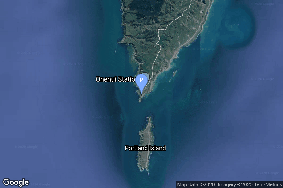
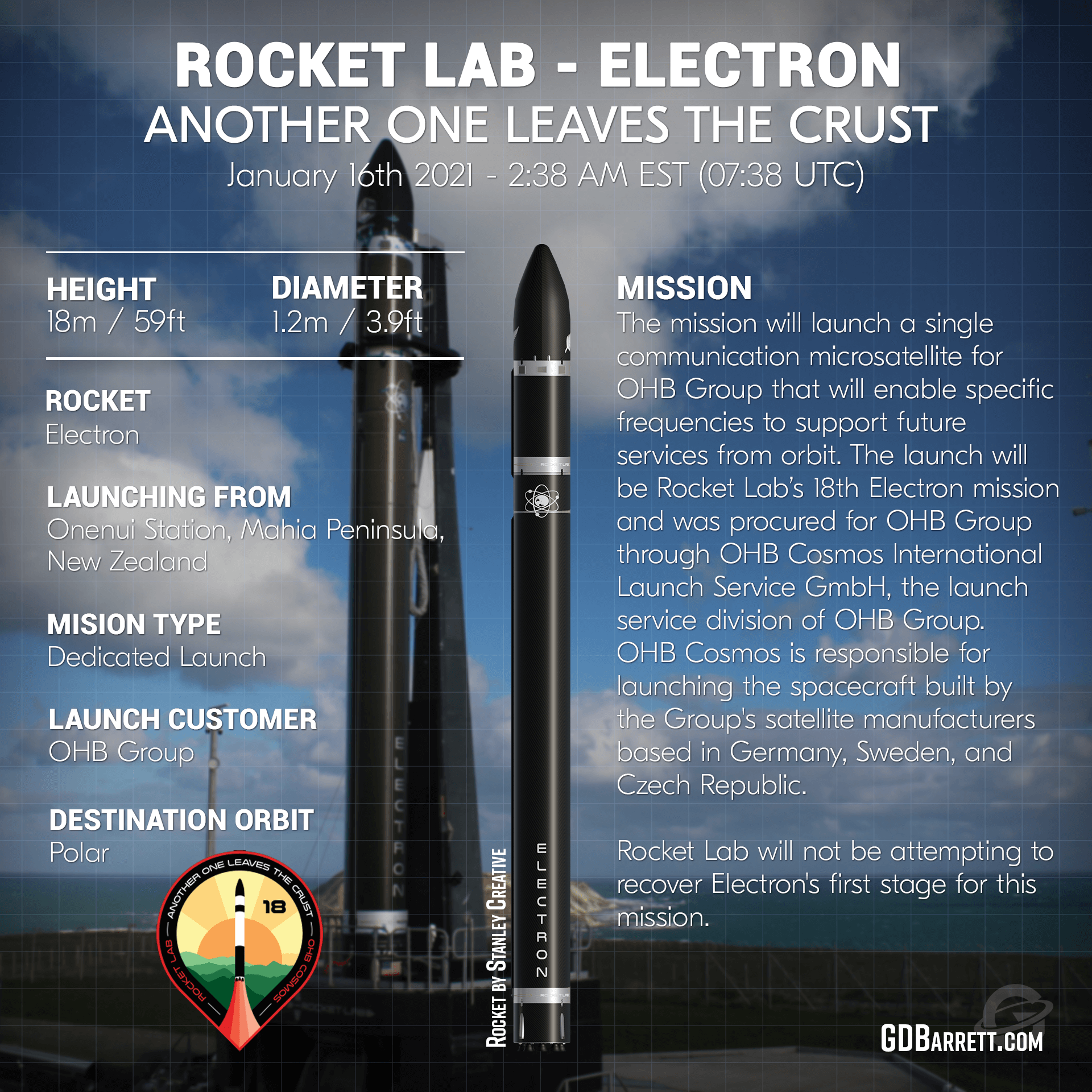
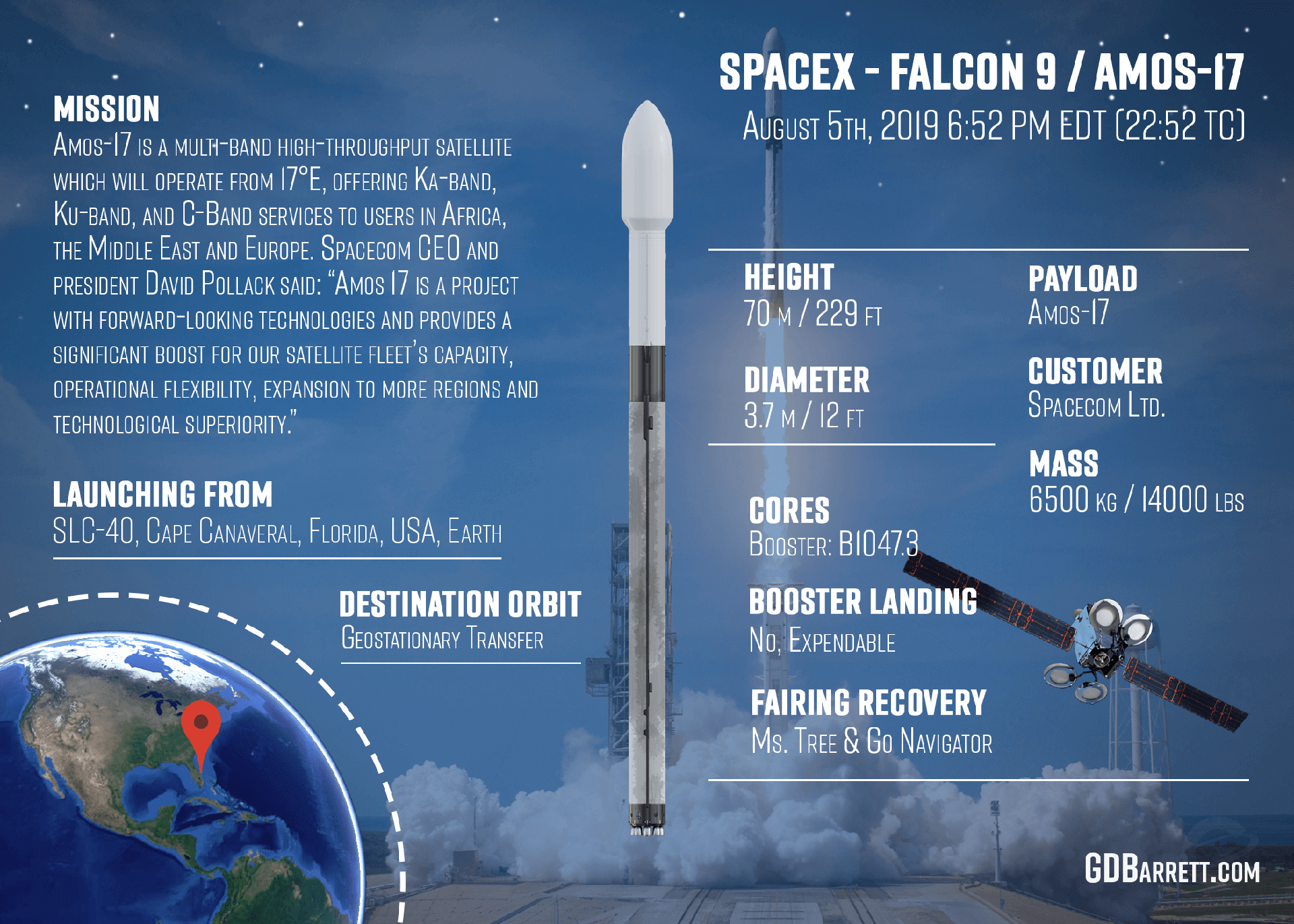
{ "count": 7913, "next": "https://ll.thespacedevs.com/2.2.0/launch/?format=api&limit=10&offset=3190&ordering=id", "previous": "https://ll.thespacedevs.com/2.2.0/launch/?format=api&limit=10&offset=3170&ordering=id", "results": [ { "id": "68a05f47-f3cc-41bc-b25f-c249d2fc014a", "url": "https://ll.thespacedevs.com/2.2.0/launch/68a05f47-f3cc-41bc-b25f-c249d2fc014a/?format=api", "slug": "tsiklon-2a-i2m-1", "name": "Tsiklon-2A | I2M 1", "status": { "id": 3, "name": "Launch Successful", "abbrev": "Success", "description": "The launch vehicle successfully inserted its payload(s) into the target orbit(s)." }, "last_updated": "2023-06-14T04:24:33Z", "net": "1968-04-24T16:00:00Z", "window_end": "1968-04-24T16:00:00Z", "window_start": "1968-04-24T16:00:00Z", "net_precision": null, "probability": null, "weather_concerns": null, "holdreason": "", "failreason": null, "hashtag": null, "launch_service_provider": { "id": 66, "url": "https://ll.thespacedevs.com/2.2.0/agencies/66/?format=api", "name": "Soviet Space Program", "type": "Government" }, "rocket": { "id": 3775, "configuration": { "id": 444, "url": "https://ll.thespacedevs.com/2.2.0/config/launcher/444/?format=api", "name": "Tsiklon-2A", "family": "Tsiklon", "full_name": "Tsiklon-2A", "variant": "2A" } }, "mission": { "id": 2193, "name": "I2M 1", "description": "The I2M satellites were maneuverable target satellites for the I2P coorbital ASAT satellites.", "launch_designator": null, "type": "Test Target", "orbit": { "id": 8, "name": "Low Earth Orbit", "abbrev": "LEO" }, "agencies": [], "info_urls": [], "vid_urls": [] }, "pad": { "id": 134, "url": "https://ll.thespacedevs.com/2.2.0/pad/134/?format=api", "agency_id": null, "name": "90/20", "description": null, "info_url": null, "wiki_url": "https://en.wikipedia.org/wiki/Baikonur_Cosmodrome_Site_90", "map_url": "https://www.google.com/maps?q=46.081,62.929806", "latitude": "46.081", "longitude": "62.929806", "location": { "id": 15, "url": "https://ll.thespacedevs.com/2.2.0/location/15/?format=api", "name": "Baikonur Cosmodrome, Republic of Kazakhstan", "country_code": "KAZ", "description": "The Baikonur Cosmodrome is a spaceport operated by Russia within Kazakhstan. Located in the Kazakh city of Baikonur, it is the largest operational space launch facility in terms of area. All Russian crewed spaceflights are launched from Baikonur.", "map_image": "https://thespacedevs-prod.nyc3.digitaloceanspaces.com/media/map_images/location_15_20200803142517.jpg", "timezone_name": "Asia/Qyzylorda", "total_launch_count": 1563, "total_landing_count": 0 }, "country_code": "KAZ", "map_image": "https://thespacedevs-prod.nyc3.digitaloceanspaces.com/media/map_images/pad_134_20200803143259.jpg", "total_launch_count": 23, "orbital_launch_attempt_count": 23 }, "webcast_live": false, "image": null, "infographic": null, "program": [], "orbital_launch_attempt_count": 827, "location_launch_attempt_count": 215, "pad_launch_attempt_count": 1, "agency_launch_attempt_count": 314, "orbital_launch_attempt_count_year": 39, "location_launch_attempt_count_year": 12, "pad_launch_attempt_count_year": 1, "agency_launch_attempt_count_year": 25, "type": "normal" }, { "id": "68ab2654-f5ed-431f-a2cc-dbb392b4d7d8", "url": "https://ll.thespacedevs.com/2.2.0/launch/68ab2654-f5ed-431f-a2cc-dbb392b4d7d8/?format=api", "slug": "vega-adm-aeolus", "name": "Vega | ADM-Aeolus", "status": { "id": 3, "name": "Launch Successful", "abbrev": "Success", "description": "The launch vehicle successfully inserted its payload(s) into the target orbit(s)." }, "last_updated": "2023-06-14T03:49:34Z", "net": "2018-08-22T21:20:09Z", "window_end": "2018-08-22T21:20:09Z", "window_start": "2018-08-22T21:20:09Z", "net_precision": null, "probability": null, "weather_concerns": null, "holdreason": "", "failreason": null, "hashtag": "#Aeolus", "launch_service_provider": { "id": 115, "url": "https://ll.thespacedevs.com/2.2.0/agencies/115/?format=api", "name": "Arianespace", "type": "Commercial" }, "rocket": { "id": 1361, "configuration": { "id": 167, "url": "https://ll.thespacedevs.com/2.2.0/config/launcher/167/?format=api", "name": "Vega", "family": "Vega", "full_name": "Vega", "variant": "" } }, "mission": { "id": 483, "name": "ADM-Aeolus", "description": "ADM-Aeolus was an Earth observation satellite built by Airbus Defense and Space for ESA. Its goal was to directly observe wind profiles from space on a global scale and provide data that could improve weather forecasting and advance understanding of atmospherics dynamics and climate. The Aeolus satellite weighed around 1366 kg and flew in a low sun-synchronous orbit at about 400 km altitude. It was desorbited and reentered the Earth's atmosphere on July 28, 2023 at approximately 19:00 UTC.", "launch_designator": null, "type": "Earth Science", "orbit": { "id": 17, "name": "Sun-Synchronous Orbit", "abbrev": "SSO" }, "agencies": [], "info_urls": [], "vid_urls": [] }, "pad": { "id": 34, "url": "https://ll.thespacedevs.com/2.2.0/pad/34/?format=api", "agency_id": 115, "name": "Ariane Launch Area 1 (ELV)", "description": "ELA-1, now named Ensemble de Lancement Vega (short ELV), is a launch pad at the Centre Spatial Guyanais in French Guiana. It has been used to support launches of the Europa rocket, Ariane 1, Ariane 3, and is currently used to launch Vega rockets.", "info_url": null, "wiki_url": "https://en.wikipedia.org/wiki/ELA-1", "map_url": "https://www.google.com/maps?q=5.236,-52.775", "latitude": "5.236", "longitude": "-52.775", "location": { "id": 13, "url": "https://ll.thespacedevs.com/2.2.0/location/13/?format=api", "name": "Guiana Space Centre, French Guiana", "country_code": "GUF", "description": "The Guiana Space Centre is a European spaceport to the northwest of Kourou in French Guiana, a region of France in South America. Kourou is located at a latitude of 5°. In operation since 1968, it is a suitable location for a spaceport because of its equatorial location and open sea to the east.", "map_image": "https://thespacedevs-prod.nyc3.digitaloceanspaces.com/media/map_images/location_13_20200803142412.jpg", "timezone_name": "America/Cayenne", "total_launch_count": 334, "total_landing_count": 0 }, "country_code": "GUF", "map_image": "https://thespacedevs-prod.nyc3.digitaloceanspaces.com/media/map_images/pad_34_20200803143527.jpg", "total_launch_count": 55, "orbital_launch_attempt_count": 55 }, "webcast_live": false, "image": "https://thespacedevs-prod.nyc3.digitaloceanspaces.com/media/images/vega_image_20201111143622.jpeg", "infographic": null, "program": [], "orbital_launch_attempt_count": 5772, "location_launch_attempt_count": 282, "pad_launch_attempt_count": 38, "agency_launch_attempt_count": 267, "orbital_launch_attempt_count_year": 66, "location_launch_attempt_count_year": 5, "pad_launch_attempt_count_year": 1, "agency_launch_attempt_count_year": 5, "type": "normal" }, { "id": "68b5c77b-5054-4e40-94dc-5523553e2880", "url": "https://ll.thespacedevs.com/2.2.0/launch/68b5c77b-5054-4e40-94dc-5523553e2880/?format=api", "slug": "kosmos-3m-strela-2m-9", "name": "Kosmos-3M | Strela-2M 9", "status": { "id": 3, "name": "Launch Successful", "abbrev": "Success", "description": "The launch vehicle successfully inserted its payload(s) into the target orbit(s)." }, "last_updated": "2023-06-14T04:27:39Z", "net": "1974-09-11T17:40:23Z", "window_end": "1974-09-11T17:40:23Z", "window_start": "1974-09-11T17:40:23Z", "net_precision": null, "probability": null, "weather_concerns": null, "holdreason": "", "failreason": null, "hashtag": null, "launch_service_provider": { "id": 66, "url": "https://ll.thespacedevs.com/2.2.0/agencies/66/?format=api", "name": "Soviet Space Program", "type": "Government" }, "rocket": { "id": 4506, "configuration": { "id": 102, "url": "https://ll.thespacedevs.com/2.2.0/config/launcher/102/?format=api", "name": "Kosmos-3M", "family": "Kosmos", "full_name": "Kosmos-3M (11K65M)", "variant": "-3M" } }, "mission": { "id": 2924, "name": "Strela-2M 9", "description": "Military communications satellite", "launch_designator": null, "type": "Government/Top Secret", "orbit": { "id": 8, "name": "Low Earth Orbit", "abbrev": "LEO" }, "agencies": [], "info_urls": [], "vid_urls": [] }, "pad": { "id": 167, "url": "https://ll.thespacedevs.com/2.2.0/pad/167/?format=api", "agency_id": null, "name": "132/2", "description": null, "info_url": null, "wiki_url": "https://en.wikipedia.org/wiki/Plesetsk_Cosmodrome", "map_url": "https://www.google.com/maps?q=62.883,40.869806", "latitude": "62.883", "longitude": "40.869806", "location": { "id": 6, "url": "https://ll.thespacedevs.com/2.2.0/location/6/?format=api", "name": "Plesetsk Cosmodrome, Russian Federation", "country_code": "RUS", "description": "Plesetsk Cosmodrome is a Russian spaceport located in Mirny, Arkhangelsk Oblast, about 800 km north of Moscow and approximately 200 km south of Arkhangelsk. Originally developed as an ICBM site for the R-7 missile, it also served for numerous satellite launches using the R-7 and other rockets. Its high latitude makes it useful only for certain types of launches, especially the Molniya orbits, so for much of the site's history it functioned as a secondary location, with most orbital launches taking place from Baikonur, in the Kazakh SSR. With the end of the Soviet Union, Baikonur became a foreign territory, and Kazakhstan charged $115 million usage fees annually. Consequently, Plesetsk has seen considerably more activity since the 2000s.", "map_image": "https://thespacedevs-prod.nyc3.digitaloceanspaces.com/media/map_images/location_6_20200803142434.jpg", "timezone_name": "Europe/Moscow", "total_launch_count": 1685, "total_landing_count": 0 }, "country_code": "RUS", "map_image": "https://thespacedevs-prod.nyc3.digitaloceanspaces.com/media/map_images/pad_167_20200803143417.jpg", "total_launch_count": 172, "orbital_launch_attempt_count": 172 }, "webcast_live": false, "image": "https://thespacedevs-prod.nyc3.digitaloceanspaces.com/media/images/kosmos-3m_durin_image_20251101171325.jpg", "infographic": null, "program": [], "orbital_launch_attempt_count": 1615, "location_launch_attempt_count": 375, "pad_launch_attempt_count": 62, "agency_launch_attempt_count": 859, "orbital_launch_attempt_count_year": 77, "location_launch_attempt_count_year": 38, "pad_launch_attempt_count_year": 9, "agency_launch_attempt_count_year": 58, "type": "normal" }, { "id": "68c95d0d-e00a-43d9-9761-dcecd4a83413", "url": "https://ll.thespacedevs.com/2.2.0/launch/68c95d0d-e00a-43d9-9761-dcecd4a83413/?format=api", "slug": "juno-ii-explorer-8", "name": "Juno II | Explorer 8", "status": { "id": 3, "name": "Launch Successful", "abbrev": "Success", "description": "The launch vehicle successfully inserted its payload(s) into the target orbit(s)." }, "last_updated": "2023-06-14T17:40:22Z", "net": "1960-11-03T05:23:10Z", "window_end": "1960-11-03T05:23:10Z", "window_start": "1960-11-03T05:23:10Z", "net_precision": null, "probability": null, "weather_concerns": null, "holdreason": "", "failreason": null, "hashtag": null, "launch_service_provider": { "id": 44, "url": "https://ll.thespacedevs.com/2.2.0/agencies/44/?format=api", "name": "National Aeronautics and Space Administration", "type": "Government" }, "rocket": { "id": 3087, "configuration": { "id": 188, "url": "https://ll.thespacedevs.com/2.2.0/config/launcher/188/?format=api", "name": "Juno II", "family": "", "full_name": "Juno II", "variant": "" } }, "mission": { "id": 1509, "name": "Explorer 8", "description": "A research satellite intended to study a number of space phenomenon.", "launch_designator": null, "type": "Earth Science", "orbit": { "id": 12, "name": "Medium Earth Orbit", "abbrev": "MEO" }, "agencies": [], "info_urls": [], "vid_urls": [] }, "pad": { "id": 97, "url": "https://ll.thespacedevs.com/2.2.0/pad/97/?format=api", "agency_id": 161, "name": "Launch Complex 26B", "description": null, "info_url": null, "wiki_url": "https://en.wikipedia.org/wiki/Cape_Canaveral_Air_Force_Station_Launch_Complex_26", "map_url": "https://www.google.com/maps?q=28.4433,-80.5712", "latitude": "28.4433", "longitude": "-80.5712", "location": { "id": 12, "url": "https://ll.thespacedevs.com/2.2.0/location/12/?format=api", "name": "Cape Canaveral SFS, FL, USA", "country_code": "USA", "description": "Cape Canaveral Space Force Station (CCSFS) is an installation of the United States Space Force's Space Launch Delta 45, located on Cape Canaveral in Brevard County, Florida.", "map_image": "https://thespacedevs-prod.nyc3.digitaloceanspaces.com/media/map_images/location_12_20200803142519.jpg", "timezone_name": "America/New_York", "total_launch_count": 1116, "total_landing_count": 75 }, "country_code": "USA", "map_image": "https://thespacedevs-prod.nyc3.digitaloceanspaces.com/media/map_images/pad_97_20200803143224.jpg", "total_launch_count": 6, "orbital_launch_attempt_count": 6 }, "webcast_live": false, "image": "https://thespacedevs-prod.nyc3.digitaloceanspaces.com/media/images/juno2520ii_image_20191201204701.jpeg", "infographic": null, "program": [], "orbital_launch_attempt_count": 84, "location_launch_attempt_count": 45, "pad_launch_attempt_count": 3, "agency_launch_attempt_count": 15, "orbital_launch_attempt_count_year": 30, "location_launch_attempt_count_year": 15, "pad_launch_attempt_count_year": 2, "agency_launch_attempt_count_year": 5, "type": "normal" }, { "id": "68dcaeb8-9c75-4cd1-bf08-3920fc6a21e1", "url": "https://ll.thespacedevs.com/2.2.0/launch/68dcaeb8-9c75-4cd1-bf08-3920fc6a21e1/?format=api", "slug": "delta-6925-marcopolo-2", "name": "Delta 6925 | Marcopolo 2", "status": { "id": 3, "name": "Launch Successful", "abbrev": "Success", "description": "The launch vehicle successfully inserted its payload(s) into the target orbit(s)." }, "last_updated": "2023-06-14T17:42:48Z", "net": "1990-08-18T00:42:00Z", "window_end": "1990-08-18T00:42:00Z", "window_start": "1990-08-18T00:42:00Z", "net_precision": null, "probability": null, "weather_concerns": null, "holdreason": "", "failreason": null, "hashtag": null, "launch_service_provider": { "id": 161, "url": "https://ll.thespacedevs.com/2.2.0/agencies/161/?format=api", "name": "United States Air Force", "type": "Government" }, "rocket": { "id": 6300, "configuration": { "id": 300, "url": "https://ll.thespacedevs.com/2.2.0/config/launcher/300/?format=api", "name": "Delta II", "family": "Delta", "full_name": "Delta II 6925", "variant": "6925" } }, "mission": { "id": 4690, "name": "Marcopolo 2", "description": "British geostationary communications satellite", "launch_designator": null, "type": "Communications", "orbit": { "id": 1, "name": "Geostationary Orbit", "abbrev": "Direct-GEO" }, "agencies": [], "info_urls": [], "vid_urls": [] }, "pad": { "id": 1, "url": "https://ll.thespacedevs.com/2.2.0/pad/1/?format=api", "agency_id": null, "name": "Space Launch Complex 17B", "description": "", "info_url": null, "wiki_url": "https://en.wikipedia.org/wiki/Cape_Canaveral_Space_Launch_Complex_17", "map_url": "https://www.google.com/maps?q=28.4458,-80.5657", "latitude": "28.4458", "longitude": "-80.5657", "location": { "id": 12, "url": "https://ll.thespacedevs.com/2.2.0/location/12/?format=api", "name": "Cape Canaveral SFS, FL, USA", "country_code": "USA", "description": "Cape Canaveral Space Force Station (CCSFS) is an installation of the United States Space Force's Space Launch Delta 45, located on Cape Canaveral in Brevard County, Florida.", "map_image": "https://thespacedevs-prod.nyc3.digitaloceanspaces.com/media/map_images/location_12_20200803142519.jpg", "timezone_name": "America/New_York", "total_launch_count": 1116, "total_landing_count": 75 }, "country_code": "USA", "map_image": "https://thespacedevs-prod.nyc3.digitaloceanspaces.com/media/map_images/pad_1_20200803143208.jpg", "total_launch_count": 132, "orbital_launch_attempt_count": 132 }, "webcast_live": false, "image": null, "infographic": null, "program": [], "orbital_launch_attempt_count": 3554, "location_launch_attempt_count": 438, "pad_launch_attempt_count": 83, "agency_launch_attempt_count": 887, "orbital_launch_attempt_count_year": 78, "location_launch_attempt_count_year": 13, "pad_launch_attempt_count_year": 4, "agency_launch_attempt_count_year": 11, "type": "normal" }, { "id": "68e1ec7d-78a9-4766-aa33-ef400623c627", "url": "https://ll.thespacedevs.com/2.2.0/launch/68e1ec7d-78a9-4766-aa33-ef400623c627/?format=api", "slug": "voskhod-zenit-4m-13", "name": "Voskhod | Zenit-4M 13", "status": { "id": 3, "name": "Launch Successful", "abbrev": "Success", "description": "The launch vehicle successfully inserted its payload(s) into the target orbit(s)." }, "last_updated": "2023-06-14T04:10:50Z", "net": "1971-03-27T10:59:59Z", "window_end": "1971-03-27T10:59:59Z", "window_start": "1971-03-27T10:59:59Z", "net_precision": null, "probability": null, "weather_concerns": null, "holdreason": "", "failreason": null, "hashtag": null, "launch_service_provider": { "id": 66, "url": "https://ll.thespacedevs.com/2.2.0/agencies/66/?format=api", "name": "Soviet Space Program", "type": "Government" }, "rocket": { "id": 4115, "configuration": { "id": 104, "url": "https://ll.thespacedevs.com/2.2.0/config/launcher/104/?format=api", "name": "Voskhod", "family": "R-7", "full_name": "Voskhod", "variant": "Voskhod" } }, "mission": { "id": 2533, "name": "Zenit-4M 13", "description": "The soviet Zenit-4M (Rotor, 11F691) was an improved version of the Zenit-4 high resolution reconnaissance satellite and was part of the Vostok-based Zenit-family.", "launch_designator": null, "type": "Government/Top Secret", "orbit": { "id": 8, "name": "Low Earth Orbit", "abbrev": "LEO" }, "agencies": [], "info_urls": [], "vid_urls": [] }, "pad": { "id": 85, "url": "https://ll.thespacedevs.com/2.2.0/pad/85/?format=api", "agency_id": 163, "name": "43/4 (43R)", "description": "", "info_url": null, "wiki_url": null, "map_url": "https://www.google.com/maps?q=62.92883,40.457098", "latitude": "62.92883", "longitude": "40.457098", "location": { "id": 6, "url": "https://ll.thespacedevs.com/2.2.0/location/6/?format=api", "name": "Plesetsk Cosmodrome, Russian Federation", "country_code": "RUS", "description": "Plesetsk Cosmodrome is a Russian spaceport located in Mirny, Arkhangelsk Oblast, about 800 km north of Moscow and approximately 200 km south of Arkhangelsk. Originally developed as an ICBM site for the R-7 missile, it also served for numerous satellite launches using the R-7 and other rockets. Its high latitude makes it useful only for certain types of launches, especially the Molniya orbits, so for much of the site's history it functioned as a secondary location, with most orbital launches taking place from Baikonur, in the Kazakh SSR. With the end of the Soviet Union, Baikonur became a foreign territory, and Kazakhstan charged $115 million usage fees annually. Consequently, Plesetsk has seen considerably more activity since the 2000s.", "map_image": "https://thespacedevs-prod.nyc3.digitaloceanspaces.com/media/map_images/location_6_20200803142434.jpg", "timezone_name": "Europe/Moscow", "total_launch_count": 1685, "total_landing_count": 0 }, "country_code": "RUS", "map_image": "https://thespacedevs-prod.nyc3.digitaloceanspaces.com/media/map_images/pad_85_20200803143554.jpg", "total_launch_count": 328, "orbital_launch_attempt_count": 328 }, "webcast_live": false, "image": "https://thespacedevs-prod.nyc3.digitaloceanspaces.com/media/images/voskhod_during__image_20251102062248.jpg", "infographic": null, "program": [], "orbital_launch_attempt_count": 1198, "location_launch_attempt_count": 170, "pad_launch_attempt_count": 15, "agency_launch_attempt_count": 556, "orbital_launch_attempt_count_year": 27, "location_launch_attempt_count_year": 9, "pad_launch_attempt_count_year": 2, "agency_launch_attempt_count_year": 15, "type": "normal" }, { "id": "68e50165-a929-424a-ab8b-ec7a1ae7465e", "url": "https://ll.thespacedevs.com/2.2.0/launch/68e50165-a929-424a-ab8b-ec7a1ae7465e/?format=api", "slug": "electron-another-one-leaves-the-crust-gms-t", "name": "Electron | Another One Leaves The Crust (GMS-T)", "status": { "id": 3, "name": "Launch Successful", "abbrev": "Success", "description": "The launch vehicle successfully inserted its payload(s) into the target orbit(s)." }, "last_updated": "2024-08-02T12:30:44Z", "net": "2021-01-20T07:26:00Z", "window_end": "2021-01-20T08:15:00Z", "window_start": "2021-01-20T06:58:00Z", "net_precision": { "id": 1, "name": "Minute", "abbrev": "MIN", "description": "The T-0 is accurate to the minute." }, "probability": null, "weather_concerns": null, "holdreason": "", "failreason": "", "hashtag": null, "launch_service_provider": { "id": 147, "url": "https://ll.thespacedevs.com/2.2.0/agencies/147/?format=api", "name": "Rocket Lab", "type": "Commercial" }, "rocket": { "id": 2816, "configuration": { "id": 26, "url": "https://ll.thespacedevs.com/2.2.0/config/launcher/26/?format=api", "name": "Electron", "family": "", "full_name": "Electron", "variant": "" } }, "mission": { "id": 1227, "name": "Another One Leaves The Crust (GMS-T)", "description": "Dedicated mission for a single communication microsatellite that will enable specific frequencies to support future services from orbit. The launch will be Rocket Lab’s 18th Electron mission.", "launch_designator": null, "type": "Communications", "orbit": { "id": 13, "name": "Polar Orbit", "abbrev": "PO" }, "agencies": [], "info_urls": [], "vid_urls": [] }, "pad": { "id": 65, "url": "https://ll.thespacedevs.com/2.2.0/pad/65/?format=api", "agency_id": 147, "name": "Rocket Lab Launch Complex 1A", "description": "", "info_url": null, "wiki_url": "https://en.wikipedia.org/wiki/Rocket_Lab_Launch_Complex_1", "map_url": "https://www.google.com/maps?q=-39.262833,177.864469", "latitude": "-39.262833", "longitude": "177.864469", "location": { "id": 10, "url": "https://ll.thespacedevs.com/2.2.0/location/10/?format=api", "name": "Rocket Lab Launch Complex 1, Mahia Peninsula, New Zealand", "country_code": "NZL", "description": "Rocket Lab Launch Complex 1 is a commercial spaceport located close to Ahuriri Point at the southern tip of Māhia Peninsula, on the east coast of New Zealand's North Island. It is owned and operated by private spaceflight company Rocket Lab and supports launches of the company's Electron rocket for small satellites. With the launch of Electron on 25 May 2017, it became the first private spaceport to host an orbital launch attempt, and the first site in New Zealand to host an orbital launch attempt. With the Electron launch of 21 January 2018, it became the first private spaceport to host a successful orbital launch.", "map_image": "https://thespacedevs-prod.nyc3.digitaloceanspaces.com/media/map_images/location_10_20200803142509.jpg", "timezone_name": "Pacific/Auckland", "total_launch_count": 77, "total_landing_count": 17 }, "country_code": "NZL", "map_image": "https://thespacedevs-prod.nyc3.digitaloceanspaces.com/media/map_images/pad_65_20200803143549.jpg", "total_launch_count": 41, "orbital_launch_attempt_count": 41 }, "webcast_live": false, "image": "https://thespacedevs-prod.nyc3.digitaloceanspaces.com/media/images/electron_image_20190705175640.jpeg", "infographic": "https://thespacedevs-prod.nyc3.digitaloceanspaces.com/media/infographic_images/electron25202_infographic_20210114192915.png", "program": [], "orbital_launch_attempt_count": 6041, "location_launch_attempt_count": 18, "pad_launch_attempt_count": 18, "agency_launch_attempt_count": 18, "orbital_launch_attempt_count_year": 4, "location_launch_attempt_count_year": 1, "pad_launch_attempt_count_year": 1, "agency_launch_attempt_count_year": 1, "type": "normal" }, { "id": "68ecf878-2491-4209-95fe-54f74fb163aa", "url": "https://ll.thespacedevs.com/2.2.0/launch/68ecf878-2491-4209-95fe-54f74fb163aa/?format=api", "slug": "falcon-9-block-5-amos-17", "name": "Falcon 9 Block 5 | Amos-17", "status": { "id": 3, "name": "Launch Successful", "abbrev": "Success", "description": "The launch vehicle successfully inserted its payload(s) into the target orbit(s)." }, "last_updated": "2023-06-14T17:41:40Z", "net": "2019-08-06T23:23:00Z", "window_end": "2019-08-07T00:21:00Z", "window_start": "2019-08-06T22:53:00Z", "net_precision": null, "probability": 40, "weather_concerns": null, "holdreason": "", "failreason": "", "hashtag": "#AMOS17", "launch_service_provider": { "id": 121, "url": "https://ll.thespacedevs.com/2.2.0/agencies/121/?format=api", "name": "SpaceX", "type": "Commercial" }, "rocket": { "id": 99, "configuration": { "id": 164, "url": "https://ll.thespacedevs.com/2.2.0/config/launcher/164/?format=api", "name": "Falcon 9", "family": "Falcon", "full_name": "Falcon 9 Block 5", "variant": "Block 5" } }, "mission": { "id": 978, "name": "Amos-17", "description": "Amos-17 is a multi-band high-throughput satellite which will operate from 17°E, offering Ka-band, Ku-band, and C-Band services to users in Africa, the Middle East and Europe.", "launch_designator": null, "type": "Communications", "orbit": { "id": 2, "name": "Geostationary Transfer Orbit", "abbrev": "GTO" }, "agencies": [], "info_urls": [], "vid_urls": [] }, "pad": { "id": 80, "url": "https://ll.thespacedevs.com/2.2.0/pad/80/?format=api", "agency_id": 121, "name": "Space Launch Complex 40", "description": "", "info_url": null, "wiki_url": "https://en.wikipedia.org/wiki/Cape_Canaveral_Air_Force_Station_Space_Launch_Complex_40", "map_url": "https://www.google.com/maps?q=28.56194122,-80.57735736", "latitude": "28.56194122", "longitude": "-80.57735736", "location": { "id": 12, "url": "https://ll.thespacedevs.com/2.2.0/location/12/?format=api", "name": "Cape Canaveral SFS, FL, USA", "country_code": "USA", "description": "Cape Canaveral Space Force Station (CCSFS) is an installation of the United States Space Force's Space Launch Delta 45, located on Cape Canaveral in Brevard County, Florida.", "map_image": "https://thespacedevs-prod.nyc3.digitaloceanspaces.com/media/map_images/location_12_20200803142519.jpg", "timezone_name": "America/New_York", "total_launch_count": 1116, "total_landing_count": 75 }, "country_code": "USA", "map_image": "https://thespacedevs-prod.nyc3.digitaloceanspaces.com/media/map_images/pad_80_20200803143323.jpg", "total_launch_count": 389, "orbital_launch_attempt_count": 389 }, "webcast_live": false, "image": "https://thespacedevs-prod.nyc3.digitaloceanspaces.com/media/images/falcon_9_image_20230807133459.jpeg", "infographic": "https://thespacedevs-prod.nyc3.digitaloceanspaces.com/media/infographic_images/falcon2520925_infographic_20200806035521.png", "program": [], "orbital_launch_attempt_count": 5875, "location_launch_attempt_count": 785, "pad_launch_attempt_count": 100, "agency_launch_attempt_count": 84, "orbital_launch_attempt_count_year": 55, "location_launch_attempt_count_year": 7, "pad_launch_attempt_count_year": 5, "agency_launch_attempt_count_year": 11, "type": "normal" }, { "id": "68fff4c3-3953-48c0-b14e-0b79ee760521", "url": "https://ll.thespacedevs.com/2.2.0/launch/68fff4c3-3953-48c0-b14e-0b79ee760521/?format=api", "slug": "voskhod-zenit-4-71", "name": "Voskhod | Zenit-4 71", "status": { "id": 3, "name": "Launch Successful", "abbrev": "Success", "description": "The launch vehicle successfully inserted its payload(s) into the target orbit(s)." }, "last_updated": "2023-06-14T03:41:05Z", "net": "1970-05-20T09:20:01Z", "window_end": "1970-05-20T09:20:01Z", "window_start": "1970-05-20T09:20:01Z", "net_precision": null, "probability": null, "weather_concerns": null, "holdreason": "", "failreason": null, "hashtag": null, "launch_service_provider": { "id": 66, "url": "https://ll.thespacedevs.com/2.2.0/agencies/66/?format=api", "name": "Soviet Space Program", "type": "Government" }, "rocket": { "id": 4010, "configuration": { "id": 104, "url": "https://ll.thespacedevs.com/2.2.0/config/launcher/104/?format=api", "name": "Voskhod", "family": "R-7", "full_name": "Voskhod", "variant": "Voskhod" } }, "mission": { "id": 2428, "name": "Zenit-4 71", "description": "Zenit-4 film-return reconnaissance satellite.", "launch_designator": null, "type": "Government/Top Secret", "orbit": { "id": 8, "name": "Low Earth Orbit", "abbrev": "LEO" }, "agencies": [], "info_urls": [], "vid_urls": [] }, "pad": { "id": 20, "url": "https://ll.thespacedevs.com/2.2.0/pad/20/?format=api", "agency_id": null, "name": "31/6", "description": "", "info_url": null, "wiki_url": "https://en.wikipedia.org/wiki/Baikonur_Cosmodrome_Site_31", "map_url": "https://www.google.com/maps?q=45.996034,63.564003", "latitude": "45.996034", "longitude": "63.564003", "location": { "id": 15, "url": "https://ll.thespacedevs.com/2.2.0/location/15/?format=api", "name": "Baikonur Cosmodrome, Republic of Kazakhstan", "country_code": "KAZ", "description": "The Baikonur Cosmodrome is a spaceport operated by Russia within Kazakhstan. Located in the Kazakh city of Baikonur, it is the largest operational space launch facility in terms of area. All Russian crewed spaceflights are launched from Baikonur.", "map_image": "https://thespacedevs-prod.nyc3.digitaloceanspaces.com/media/map_images/location_15_20200803142517.jpg", "timezone_name": "Asia/Qyzylorda", "total_launch_count": 1563, "total_landing_count": 0 }, "country_code": "KAZ", "map_image": "https://thespacedevs-prod.nyc3.digitaloceanspaces.com/media/map_images/pad_20_20200803143516.jpg", "total_launch_count": 428, "orbital_launch_attempt_count": 428 }, "webcast_live": false, "image": "https://thespacedevs-prod.nyc3.digitaloceanspaces.com/media/images/voskhod_during__image_20251102062248.jpg", "infographic": null, "program": [], "orbital_launch_attempt_count": 1087, "location_launch_attempt_count": 287, "pad_launch_attempt_count": 96, "agency_launch_attempt_count": 479, "orbital_launch_attempt_count_year": 41, "location_launch_attempt_count_year": 4, "pad_launch_attempt_count_year": 3, "agency_launch_attempt_count_year": 26, "type": "normal" }, { "id": "69073ef9-0809-42d7-bcac-5c33eb9f72a0", "url": "https://ll.thespacedevs.com/2.2.0/launch/69073ef9-0809-42d7-bcac-5c33eb9f72a0/?format=api", "slug": "space-shuttle-discovery-ov-103-sts-39", "name": "Space Shuttle Discovery / OV-103 | STS-39", "status": { "id": 3, "name": "Launch Successful", "abbrev": "Success", "description": "The launch vehicle successfully inserted its payload(s) into the target orbit(s)." }, "last_updated": "2023-06-14T08:48:09Z", "net": "1991-04-28T11:33:14Z", "window_end": "1991-04-28T11:33:14Z", "window_start": "1991-04-28T11:33:14Z", "net_precision": null, "probability": null, "weather_concerns": null, "holdreason": "", "failreason": null, "hashtag": null, "launch_service_provider": { "id": 192, "url": "https://ll.thespacedevs.com/2.2.0/agencies/192/?format=api", "name": "Lockheed Space Operations Company", "type": "Commercial" }, "rocket": { "id": 342, "configuration": { "id": 493, "url": "https://ll.thespacedevs.com/2.2.0/config/launcher/493/?format=api", "name": "Space Shuttle", "family": "", "full_name": "Space Shuttle", "variant": "" } }, "mission": { "id": 715, "name": "STS-39", "description": "STS-39 was the twelfth mission of the Space Shuttle Discovery and its primary purpose was to conduct a variety of payload experiments for the Department of Defence.", "launch_designator": null, "type": "Government/Top Secret", "orbit": { "id": 8, "name": "Low Earth Orbit", "abbrev": "LEO" }, "agencies": [], "info_urls": [], "vid_urls": [] }, "pad": { "id": 87, "url": "https://ll.thespacedevs.com/2.2.0/pad/87/?format=api", "agency_id": 121, "name": "Launch Complex 39A", "description": "", "info_url": null, "wiki_url": "https://en.wikipedia.org/wiki/Kennedy_Space_Center_Launch_Complex_39#Launch_Pad_39A", "map_url": "https://www.google.com/maps?q=28.60822681,-80.60428186", "latitude": "28.60822681", "longitude": "-80.60428186", "location": { "id": 27, "url": "https://ll.thespacedevs.com/2.2.0/location/27/?format=api", "name": "Kennedy Space Center, FL, USA", "country_code": "USA", "description": "The John F. Kennedy Space Center, located on Merritt Island, Florida, is one of NASA's ten field centers. Since 1968, KSC has been NASA's primary launch center of American spaceflight, research, and technology. Launch operations for the Apollo, Skylab and Space Shuttle programs were carried out from Kennedy Space Center Launch Complex 39 and managed by KSC. Located on the east coast of Florida, KSC is adjacent to Cape Canaveral Space Force Station (CCSFS).", "map_image": "https://thespacedevs-prod.nyc3.digitaloceanspaces.com/media/map_images/location_27_20200803142447.jpg", "timezone_name": "America/New_York", "total_launch_count": 281, "total_landing_count": 0 }, "country_code": "USA", "map_image": "https://thespacedevs-prod.nyc3.digitaloceanspaces.com/media/map_images/pad_87_20200803143537.jpg", "total_launch_count": 222, "orbital_launch_attempt_count": 221 }, "webcast_live": false, "image": "https://thespacedevs-prod.nyc3.digitaloceanspaces.com/media/images/space_shuttle_image_20230422074810.jpeg", "infographic": null, "program": [ { "id": 6, "url": "https://ll.thespacedevs.com/2.2.0/program/6/?format=api", "name": "Space Shuttle", "description": "The Space Shuttle program was the fourth human spaceflight program carried out by the National Aeronautics and Space Administration (NASA), which accomplished routine transportation for Earth-to-orbit crew and cargo from 1981 to 2011.", "agencies": [ { "id": 44, "url": "https://ll.thespacedevs.com/2.2.0/agencies/44/?format=api", "name": "National Aeronautics and Space Administration", "type": "Government" } ], "image_url": "https://thespacedevs-prod.nyc3.digitaloceanspaces.com/media/images/space2520shutt_program_20200820202237.png", "start_date": "1981-04-12T12:00:03Z", "end_date": "2011-07-08T15:29:00Z", "info_url": "https://www.nasa.gov/mission_pages/shuttle/main/index.html", "wiki_url": "https://en.wikipedia.org/wiki/Space_Shuttle_program", "mission_patches": [], "type": { "id": 2, "name": "Human Spaceflight" } } ], "orbital_launch_attempt_count": 3629, "location_launch_attempt_count": 57, "pad_launch_attempt_count": 40, "agency_launch_attempt_count": 31, "orbital_launch_attempt_count_year": 32, "location_launch_attempt_count_year": 2, "pad_launch_attempt_count_year": 1, "agency_launch_attempt_count_year": 2, "type": "normal" } ] }