Launch List
AN API endpoint that returns all Launch objects or a single launch.
EXAMPLE - /launch/[id]/ or /launch/?mode=list&search=SpaceX
GET Return a list of all Launch objects.
FILTERS Fields - 'name', 'id(s)', 'lsp__id', 'lsp__name', 'serial_number', 'launcher_config__id', 'rocket__spacecraftflight__spacecraft__name', 'is_crewed', 'include_suborbital', 'spacecraft_config__ids', 'related', 'location__ids', 'lsp__ids', 'pad__ids', 'status__ids'
MODE 'normal', 'list', 'detailed'
EXAMPLE ?mode=list
SEARCH Searches through the launch name, rocket name, launch agency, mission name & spacecraft name.
EXAMPLE - ?search=SpaceX
GET /2.2.0/launch/?format=api&offset=120&ordering=-last_updated
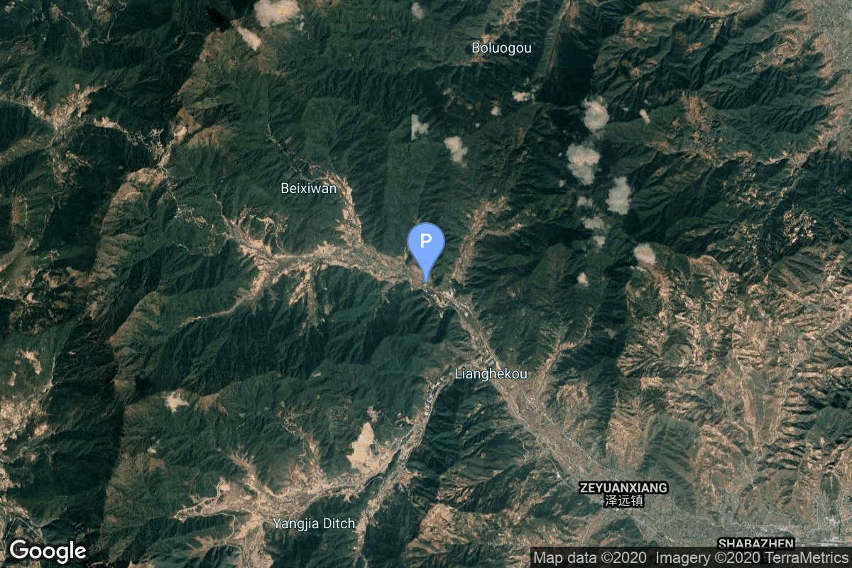
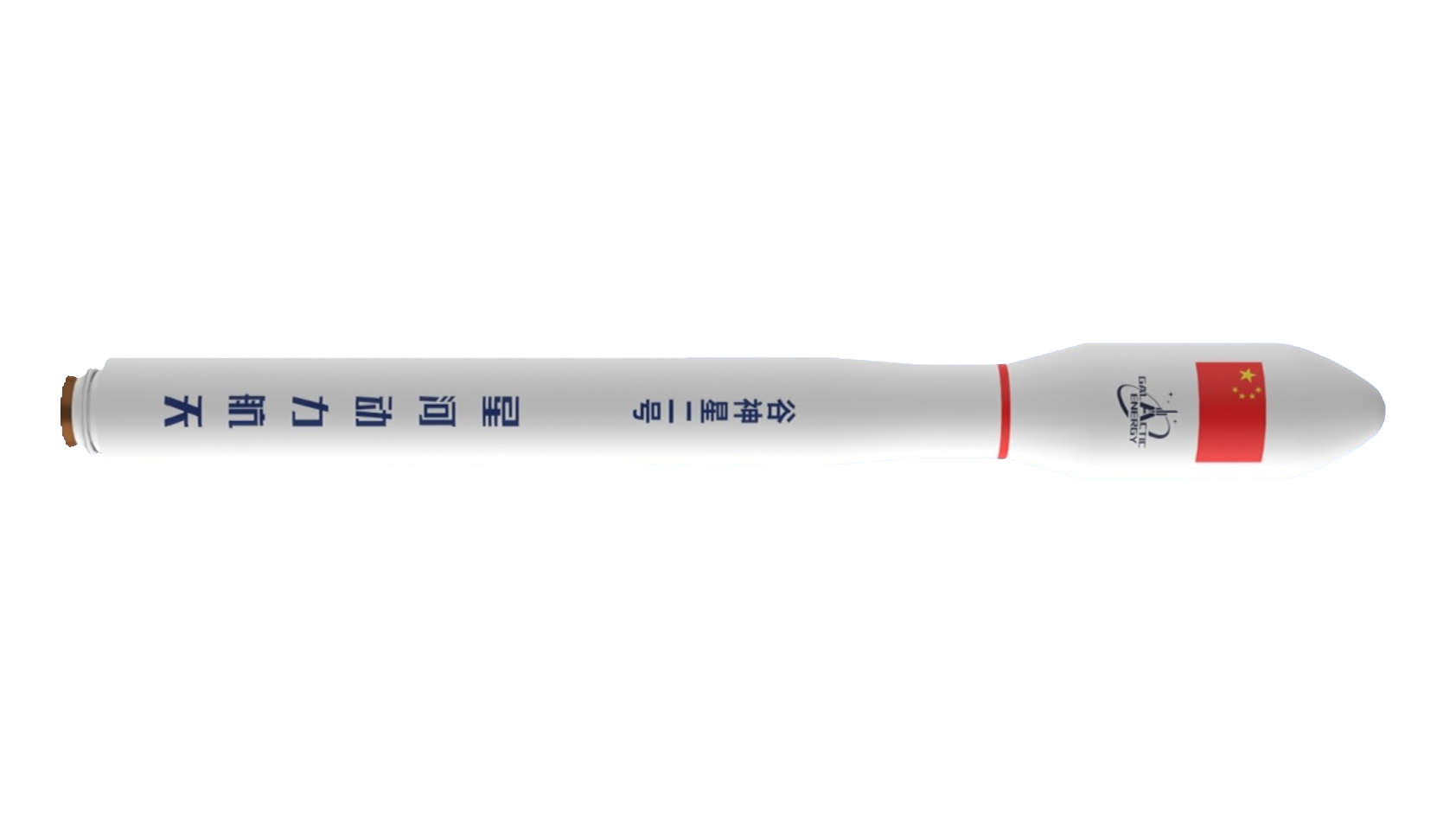
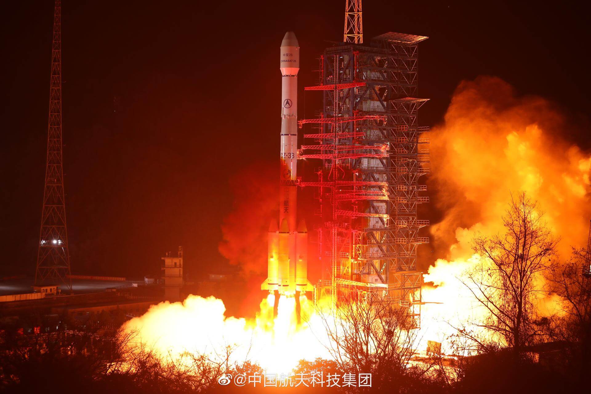
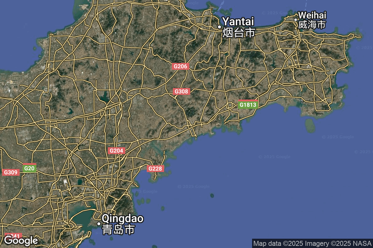
{ "count": 7805, "next": "https://ll.thespacedevs.com/2.2.0/launch/?format=api&limit=10&offset=130&ordering=-last_updated", "previous": "https://ll.thespacedevs.com/2.2.0/launch/?format=api&limit=10&offset=110&ordering=-last_updated", "results": [ { "id": "7650a17a-cc52-4597-bd1a-0951d7389a95", "url": "https://ll.thespacedevs.com/2.2.0/launch/7650a17a-cc52-4597-bd1a-0951d7389a95/?format=api", "slug": "ceres-2-demo-flight", "name": "Ceres-2 | Demo Flight", "status": { "id": 4, "name": "Launch Failure", "abbrev": "Failure", "description": "Either the launch vehicle did not reach orbit, or the payload(s) failed to separate." }, "last_updated": "2026-01-17T06:53:25Z", "net": "2026-01-17T04:08:00Z", "window_end": "2026-01-17T04:20:00Z", "window_start": "2026-01-17T03:57:00Z", "net_precision": { "id": 1, "name": "Minute", "abbrev": "MIN", "description": "The T-0 is accurate to the minute." }, "probability": null, "weather_concerns": null, "holdreason": "", "failreason": "1st stage failure, failed to reach orbit.", "hashtag": null, "launch_service_provider": { "id": 1021, "url": "https://ll.thespacedevs.com/2.2.0/agencies/1021/?format=api", "name": "Galactic Energy", "type": "Commercial" }, "rocket": { "id": 8828, "configuration": { "id": 546, "url": "https://ll.thespacedevs.com/2.2.0/config/launcher/546/?format=api", "name": "Ceres-2", "family": "", "full_name": "Ceres-2", "variant": "" } }, "mission": { "id": 7419, "name": "Demo Flight", "description": "First test launch of Galactic Energy’s Ceres-2 rocket.", "launch_designator": null, "type": "Test Flight", "orbit": { "id": 25, "name": "Unknown", "abbrev": "N/A" }, "agencies": [], "info_urls": [], "vid_urls": [] }, "pad": { "id": 21, "url": "https://ll.thespacedevs.com/2.2.0/pad/21/?format=api", "agency_id": null, "name": "Launch Area 95A", "description": "", "info_url": null, "wiki_url": "https://en.wikipedia.org/wiki/Jiuquan_Satellite_Launch_Center", "map_url": "https://www.google.com/maps?q=40.969117,100.343333", "latitude": "40.969117", "longitude": "100.343333", "location": { "id": 17, "url": "https://ll.thespacedevs.com/2.2.0/location/17/?format=api", "name": "Jiuquan Satellite Launch Center, People's Republic of China", "country_code": "CHN", "description": "Jiuquan Satellite Launch Center is a Chinese spaceport located between the Ejin, Alxa, Inner Mongolia and Hangtian Town, Jinta County, Jiuquan, Gansu Province. It is part of the Dongfeng Aerospace City (Base 10).", "map_image": "https://thespacedevs-prod.nyc3.digitaloceanspaces.com/media/map_images/location_17_20200803142429.jpg", "timezone_name": "Asia/Shanghai", "total_launch_count": 277, "total_landing_count": 2 }, "country_code": "CHN", "map_image": "https://thespacedevs-prod.nyc3.digitaloceanspaces.com/media/map_images/pad_21_20200803143253.jpg", "total_launch_count": 65, "orbital_launch_attempt_count": 65 }, "webcast_live": false, "image": "https://thespacedevs-prod.nyc3.digitaloceanspaces.com/media/images/ceres-2_illustr_image_20251210054657.png", "infographic": null, "program": [], "orbital_launch_attempt_count": 7186, "location_launch_attempt_count": 275, "pad_launch_attempt_count": 65, "agency_launch_attempt_count": 24, "orbital_launch_attempt_count_year": 13, "location_launch_attempt_count_year": 2, "pad_launch_attempt_count_year": 1, "agency_launch_attempt_count_year": 2, "type": "normal" }, { "id": "67068998-010a-40cc-8bc8-a60743cda331", "url": "https://ll.thespacedevs.com/2.2.0/launch/67068998-010a-40cc-8bc8-a60743cda331/?format=api", "slug": "long-march-3be-shijian-32", "name": "Long March 3B/E | Shijian 32", "status": { "id": 4, "name": "Launch Failure", "abbrev": "Failure", "description": "Either the launch vehicle did not reach orbit, or the payload(s) failed to separate." }, "last_updated": "2026-01-17T05:51:51Z", "net": "2026-01-16T16:55:00Z", "window_end": "2026-01-16T17:34:00Z", "window_start": "2026-01-16T16:47:00Z", "net_precision": { "id": 1, "name": "Minute", "abbrev": "MIN", "description": "The T-0 is accurate to the minute." }, "probability": null, "weather_concerns": null, "holdreason": "", "failreason": "3rd stage failure, failed to reach orbit.", "hashtag": null, "launch_service_provider": { "id": 88, "url": "https://ll.thespacedevs.com/2.2.0/agencies/88/?format=api", "name": "China Aerospace Science and Technology Corporation", "type": "Government" }, "rocket": { "id": 8873, "configuration": { "id": 50, "url": "https://ll.thespacedevs.com/2.2.0/config/launcher/50/?format=api", "name": "Long March 3B/E", "family": "Long March", "full_name": "Long March 3B/E", "variant": "B/E" } }, "mission": { "id": 7464, "name": "Shijian 32", "description": "Chinese experimental spacecraft of unknown purposes.", "launch_designator": null, "type": "Government/Top Secret", "orbit": { "id": 2, "name": "Geostationary Transfer Orbit", "abbrev": "GTO" }, "agencies": [], "info_urls": [], "vid_urls": [] }, "pad": { "id": 45, "url": "https://ll.thespacedevs.com/2.2.0/pad/45/?format=api", "agency_id": null, "name": "Launch Complex 2 (LC-2)", "description": "", "info_url": null, "wiki_url": "https://en.wikipedia.org/wiki/Xichang_Satellite_Launch_Center", "map_url": "https://www.google.com/maps?q=28.245564,102.026751", "latitude": "28.245564", "longitude": "102.026751", "location": { "id": 16, "url": "https://ll.thespacedevs.com/2.2.0/location/16/?format=api", "name": "Xichang Satellite Launch Center, People's Republic of China", "country_code": "CHN", "description": "The Xichang Satellite Launch Center is a spaceport in China. It is located in Zeyuan Town, northwest of Xichang, Liangshan Yi Autonomous Prefecture in Sichuan.", "map_image": "https://thespacedevs-prod.nyc3.digitaloceanspaces.com/media/map_images/location_16_20200803142513.jpg", "timezone_name": "Asia/Shanghai", "total_launch_count": 237, "total_landing_count": 0 }, "country_code": "CHN", "map_image": "https://thespacedevs-prod.nyc3.digitaloceanspaces.com/media/map_images/pad_45_20200803143520.jpg", "total_launch_count": 124, "orbital_launch_attempt_count": 124 }, "webcast_live": false, "image": "https://thespacedevs-prod.nyc3.digitaloceanspaces.com/media/images/long2520march_image_20230907120240.jpeg", "infographic": null, "program": [], "orbital_launch_attempt_count": 7185, "location_launch_attempt_count": 237, "pad_launch_attempt_count": 124, "agency_launch_attempt_count": 574, "orbital_launch_attempt_count_year": 12, "location_launch_attempt_count_year": 1, "pad_launch_attempt_count_year": 1, "agency_launch_attempt_count_year": 4, "type": "normal" }, { "id": "f004b764-e63d-4dff-b372-1a558e0c7a59", "url": "https://ll.thespacedevs.com/2.2.0/launch/f004b764-e63d-4dff-b372-1a558e0c7a59/?format=api", "slug": "long-march-11-jilin-1-hr-03d-04-to-07-04a", "name": "Long March 11 | Jilin-1 HR-03D-04 to 07 & 04A", "status": { "id": 3, "name": "Launch Successful", "abbrev": "Success", "description": "The launch vehicle successfully inserted its payload(s) into the target orbit(s)." }, "last_updated": "2026-01-16T13:12:06Z", "net": "2022-04-30T03:30:00Z", "window_end": "2022-04-30T04:34:00Z", "window_start": "2022-04-30T03:19:00Z", "net_precision": null, "probability": null, "weather_concerns": null, "holdreason": "", "failreason": "", "hashtag": null, "launch_service_provider": { "id": 88, "url": "https://ll.thespacedevs.com/2.2.0/agencies/88/?format=api", "name": "China Aerospace Science and Technology Corporation", "type": "Government" }, "rocket": { "id": 7571, "configuration": { "id": 47, "url": "https://ll.thespacedevs.com/2.2.0/config/launcher/47/?format=api", "name": "Long March 11", "family": "Long March", "full_name": "Long March 11", "variant": "" } }, "mission": { "id": 6014, "name": "Jilin-1 Gaofen 03D-04 to 07 & 04A", "description": "Earth observation satellites for the Jilin-1 commercial Earth observation satellites constellation.", "launch_designator": null, "type": "Earth Science", "orbit": { "id": 17, "name": "Sun-Synchronous Orbit", "abbrev": "SSO" }, "agencies": [], "info_urls": [], "vid_urls": [] }, "pad": { "id": 248, "url": "https://ll.thespacedevs.com/2.2.0/pad/248/?format=api", "agency_id": 88, "name": "Yellow Sea (launch location 3)", "description": "", "info_url": null, "wiki_url": null, "map_url": "https://www.google.com/maps?q=32.183333,123.8", "latitude": "32.183333", "longitude": "123.8", "location": { "id": 185, "url": "https://ll.thespacedevs.com/2.2.0/location/185/?format=api", "name": "Haiyang Oriental Spaceport", "country_code": "CHN", "description": "Chinese orbital launch vehicle launches supporting sea port located at Haiyang, Shandong Province, with dedicated piers and rocket/payload processing facilities for Chinese launch vehicles’ sea launches, and (as part of its expansion project) land based launch pads on artificial islands for various test vehicles and launch vehicles of private and government launch services providers.\r\n\r\nIn operation as a remote base of Taiyuan Satellite Launch Center since 2019.", "map_image": "https://thespacedevs-prod.nyc3.digitaloceanspaces.com/media/map_images/location_haiyang_oriental_spaceport_20251128181322.jpg", "timezone_name": "Asia/Shanghai", "total_launch_count": 23, "total_landing_count": 0 }, "country_code": "CHN", "map_image": "https://thespacedevs-prod.nyc3.digitaloceanspaces.com/media/map_images/pad_yellow_sea_2528launch_location_32529_20260116130314.jpg", "total_launch_count": 1, "orbital_launch_attempt_count": 1 }, "webcast_live": false, "image": "https://thespacedevs-prod.nyc3.digitaloceanspaces.com/media/images/long2520march252011_image_20190222031217.jpeg", "infographic": null, "program": [], "orbital_launch_attempt_count": 6229, "location_launch_attempt_count": 3, "pad_launch_attempt_count": 1, "agency_launch_attempt_count": 365, "orbital_launch_attempt_count_year": 47, "location_launch_attempt_count_year": 1, "pad_launch_attempt_count_year": 1, "agency_launch_attempt_count_year": 13, "type": "normal" }, { "id": "414f8c17-95af-47e4-9b3f-1768e87254b8", "url": "https://ll.thespacedevs.com/2.2.0/launch/414f8c17-95af-47e4-9b3f-1768e87254b8/?format=api", "slug": "smart-dragon-3-maiden-flight", "name": "Smart Dragon 3 | Maiden Flight", "status": { "id": 3, "name": "Launch Successful", "abbrev": "Success", "description": "The launch vehicle successfully inserted its payload(s) into the target orbit(s)." }, "last_updated": "2026-01-16T13:11:36Z", "net": "2022-12-09T06:35:00Z", "window_end": "2022-12-09T07:38:00Z", "window_start": "2022-12-09T06:25:00Z", "net_precision": null, "probability": null, "weather_concerns": null, "holdreason": "", "failreason": "", "hashtag": null, "launch_service_provider": { "id": 272, "url": "https://ll.thespacedevs.com/2.2.0/agencies/272/?format=api", "name": "China Rocket Co. Ltd.", "type": "Commercial" }, "rocket": { "id": 7726, "configuration": { "id": 484, "url": "https://ll.thespacedevs.com/2.2.0/config/launcher/484/?format=api", "name": "Smart Dragon 3", "family": "Smart Dragon", "full_name": "Smart Dragon 3", "variant": "" } }, "mission": { "id": 6243, "name": "Maiden Flight", "description": "First flight of the new solid fuel powered rocket developed by CAST.\r\n\r\nPayload consists of 14 satellites:\r\n\r\n* Jilin-1 HR-03D 44-50\r\n* Jilin-1 PT-01A 01\r\n* Tianqi-7\r\n* HEAD-2H\r\n* CAS-5A\r\n* Golden Bauhinia 1-05 & 06\r\n* Huoju-1", "launch_designator": null, "type": "Test Flight", "orbit": { "id": 8, "name": "Low Earth Orbit", "abbrev": "LEO" }, "agencies": [], "info_urls": [], "vid_urls": [] }, "pad": { "id": 249, "url": "https://ll.thespacedevs.com/2.2.0/pad/249/?format=api", "agency_id": 88, "name": "Yellow Sea (launch location 4)", "description": "", "info_url": null, "wiki_url": null, "map_url": "https://www.google.com/maps?q=37.3395,123.7115", "latitude": "37.3395", "longitude": "123.7115", "location": { "id": 185, "url": "https://ll.thespacedevs.com/2.2.0/location/185/?format=api", "name": "Haiyang Oriental Spaceport", "country_code": "CHN", "description": "Chinese orbital launch vehicle launches supporting sea port located at Haiyang, Shandong Province, with dedicated piers and rocket/payload processing facilities for Chinese launch vehicles’ sea launches, and (as part of its expansion project) land based launch pads on artificial islands for various test vehicles and launch vehicles of private and government launch services providers.\r\n\r\nIn operation as a remote base of Taiyuan Satellite Launch Center since 2019.", "map_image": "https://thespacedevs-prod.nyc3.digitaloceanspaces.com/media/map_images/location_haiyang_oriental_spaceport_20251128181322.jpg", "timezone_name": "Asia/Shanghai", "total_launch_count": 23, "total_landing_count": 0 }, "country_code": "CHN", "map_image": "https://thespacedevs-prod.nyc3.digitaloceanspaces.com/media/map_images/pad_yellow_sea_2528launch_location_42529_20260116130402.jpg", "total_launch_count": 1, "orbital_launch_attempt_count": 1 }, "webcast_live": false, "image": "https://thespacedevs-prod.nyc3.digitaloceanspaces.com/media/images/smart_dragon_3__image_20240925074606.jpg", "infographic": null, "program": [], "orbital_launch_attempt_count": 6354, "location_launch_attempt_count": 5, "pad_launch_attempt_count": 1, "agency_launch_attempt_count": 2, "orbital_launch_attempt_count_year": 172, "location_launch_attempt_count_year": 3, "pad_launch_attempt_count_year": 1, "agency_launch_attempt_count_year": 1, "type": "normal" }, { "id": "e4d243bc-153c-454f-a426-69100b0daedc", "url": "https://ll.thespacedevs.com/2.2.0/launch/e4d243bc-153c-454f-a426-69100b0daedc/?format=api", "slug": "gravity-1-maiden-flight", "name": "Gravity-1 | Maiden flight", "status": { "id": 3, "name": "Launch Successful", "abbrev": "Success", "description": "The launch vehicle successfully inserted its payload(s) into the target orbit(s)." }, "last_updated": "2026-01-16T13:10:14Z", "net": "2024-01-11T05:30:00Z", "window_end": "2024-01-11T07:05:00Z", "window_start": "2024-01-11T05:15:00Z", "net_precision": { "id": 1, "name": "Minute", "abbrev": "MIN", "description": "The T-0 is accurate to the minute." }, "probability": null, "weather_concerns": null, "holdreason": "", "failreason": "", "hashtag": null, "launch_service_provider": { "id": 1080, "url": "https://ll.thespacedevs.com/2.2.0/agencies/1080/?format=api", "name": "Orienspace Technology", "type": "Commercial" }, "rocket": { "id": 8157, "configuration": { "id": 503, "url": "https://ll.thespacedevs.com/2.2.0/config/launcher/503/?format=api", "name": "Gravity-1", "family": "", "full_name": "Gravity-1", "variant": "Gravity-1" } }, "mission": { "id": 6718, "name": "Maiden flight", "description": "First launch of Chinese private company OrienSpace's Gravity-1 launch vehicle from an ocean-going launch platform. Payload is Yunyao-1 18-20, 3 weather satellites performing atmospheric measurements using GNSS Radio Occultation for a Tianjin based company. Constellation is planned to have an eventual 90 satellites.", "launch_designator": null, "type": "Earth Science", "orbit": { "id": 8, "name": "Low Earth Orbit", "abbrev": "LEO" }, "agencies": [], "info_urls": [], "vid_urls": [] }, "pad": { "id": 89, "url": "https://ll.thespacedevs.com/2.2.0/pad/89/?format=api", "agency_id": 88, "name": "Haiyang offshore launch location", "description": "", "info_url": null, "wiki_url": null, "map_url": "https://www.google.com/maps?q=36.631333,121.198361", "latitude": "36.631333", "longitude": "121.198361", "location": { "id": 185, "url": "https://ll.thespacedevs.com/2.2.0/location/185/?format=api", "name": "Haiyang Oriental Spaceport", "country_code": "CHN", "description": "Chinese orbital launch vehicle launches supporting sea port located at Haiyang, Shandong Province, with dedicated piers and rocket/payload processing facilities for Chinese launch vehicles’ sea launches, and (as part of its expansion project) land based launch pads on artificial islands for various test vehicles and launch vehicles of private and government launch services providers.\r\n\r\nIn operation as a remote base of Taiyuan Satellite Launch Center since 2019.", "map_image": "https://thespacedevs-prod.nyc3.digitaloceanspaces.com/media/map_images/location_haiyang_oriental_spaceport_20251128181322.jpg", "timezone_name": "Asia/Shanghai", "total_launch_count": 23, "total_landing_count": 0 }, "country_code": "CHN", "map_image": "https://thespacedevs-prod.nyc3.digitaloceanspaces.com/media/map_images/pad_89_20200803143242.jpg", "total_launch_count": 8, "orbital_launch_attempt_count": 8 }, "webcast_live": false, "image": "https://thespacedevs-prod.nyc3.digitaloceanspaces.com/media/images/gravity-12520_image_20240112065126.jpg", "infographic": null, "program": [], "orbital_launch_attempt_count": 6598, "location_launch_attempt_count": 9, "pad_launch_attempt_count": 3, "agency_launch_attempt_count": 1, "orbital_launch_attempt_count_year": 9, "location_launch_attempt_count_year": 1, "pad_launch_attempt_count_year": 1, "agency_launch_attempt_count_year": 1, "type": "normal" }, { "id": "5a30129a-8ec6-4189-999e-b9fa22fc4688", "url": "https://ll.thespacedevs.com/2.2.0/launch/5a30129a-8ec6-4189-999e-b9fa22fc4688/?format=api", "slug": "smart-dragon-3-9-satellites", "name": "Smart Dragon 3 | 9 satellites", "status": { "id": 3, "name": "Launch Successful", "abbrev": "Success", "description": "The launch vehicle successfully inserted its payload(s) into the target orbit(s)." }, "last_updated": "2026-01-16T13:09:57Z", "net": "2024-02-03T03:06:00Z", "window_end": "2024-02-03T03:16:00Z", "window_start": "2024-02-03T02:56:00Z", "net_precision": { "id": 1, "name": "Minute", "abbrev": "MIN", "description": "The T-0 is accurate to the minute." }, "probability": null, "weather_concerns": null, "holdreason": "", "failreason": "", "hashtag": null, "launch_service_provider": { "id": 272, "url": "https://ll.thespacedevs.com/2.2.0/agencies/272/?format=api", "name": "China Rocket Co. Ltd.", "type": "Commercial" }, "rocket": { "id": 8176, "configuration": { "id": 484, "url": "https://ll.thespacedevs.com/2.2.0/config/launcher/484/?format=api", "name": "Smart Dragon 3", "family": "Smart Dragon", "full_name": "Smart Dragon 3", "variant": "" } }, "mission": { "id": 6743, "name": "9 satellites", "description": "Carried 9 satellites to Sun-synchronous orbit:\r\n\r\n* DRO-L\r\n* Zhixing-2A (SmartSat-2A)\r\n* DongFangHuiYan-GF01\r\n* WeiHai-1-01/02\r\n* XingShiDai-18/19/20\r\n* NEXSAT-1", "launch_designator": null, "type": "Technology", "orbit": { "id": 17, "name": "Sun-Synchronous Orbit", "abbrev": "SSO" }, "agencies": [], "info_urls": [], "vid_urls": [] }, "pad": { "id": 250, "url": "https://ll.thespacedevs.com/2.2.0/pad/250/?format=api", "agency_id": 88, "name": "South China Sea (launch location 2)", "description": "", "info_url": null, "wiki_url": null, "map_url": "https://www.google.com/maps?q=21.566667,112.033333", "latitude": "21.566667", "longitude": "112.033333", "location": { "id": 185, "url": "https://ll.thespacedevs.com/2.2.0/location/185/?format=api", "name": "Haiyang Oriental Spaceport", "country_code": "CHN", "description": "Chinese orbital launch vehicle launches supporting sea port located at Haiyang, Shandong Province, with dedicated piers and rocket/payload processing facilities for Chinese launch vehicles’ sea launches, and (as part of its expansion project) land based launch pads on artificial islands for various test vehicles and launch vehicles of private and government launch services providers.\r\n\r\nIn operation as a remote base of Taiyuan Satellite Launch Center since 2019.", "map_image": "https://thespacedevs-prod.nyc3.digitaloceanspaces.com/media/map_images/location_haiyang_oriental_spaceport_20251128181322.jpg", "timezone_name": "Asia/Shanghai", "total_launch_count": 23, "total_landing_count": 0 }, "country_code": "CHN", "map_image": "https://thespacedevs-prod.nyc3.digitaloceanspaces.com/media/map_images/pad_south_china_sea_2528launch_location_22529_20260116130455.jpg", "total_launch_count": 1, "orbital_launch_attempt_count": 1 }, "webcast_live": false, "image": "https://thespacedevs-prod.nyc3.digitaloceanspaces.com/media/images/smart2520drago_image_20240204094625.jpeg", "infographic": null, "program": [], "orbital_launch_attempt_count": 6613, "location_launch_attempt_count": 10, "pad_launch_attempt_count": 1, "agency_launch_attempt_count": 4, "orbital_launch_attempt_count_year": 24, "location_launch_attempt_count_year": 2, "pad_launch_attempt_count_year": 1, "agency_launch_attempt_count_year": 1, "type": "normal" }, { "id": "9a5fe2ad-1089-4b16-bf94-273b0f426741", "url": "https://ll.thespacedevs.com/2.2.0/launch/9a5fe2ad-1089-4b16-bf94-273b0f426741/?format=api", "slug": "ceres-1s-6-satellites", "name": "Ceres-1S | 6 satellites", "status": { "id": 3, "name": "Launch Successful", "abbrev": "Success", "description": "The launch vehicle successfully inserted its payload(s) into the target orbit(s)." }, "last_updated": "2026-01-16T13:09:27Z", "net": "2024-08-29T05:22:00Z", "window_end": "2024-08-29T05:35:00Z", "window_start": "2024-08-29T05:10:00Z", "net_precision": { "id": 1, "name": "Minute", "abbrev": "MIN", "description": "The T-0 is accurate to the minute." }, "probability": null, "weather_concerns": null, "holdreason": "", "failreason": "", "hashtag": null, "launch_service_provider": { "id": 1021, "url": "https://ll.thespacedevs.com/2.2.0/agencies/1021/?format=api", "name": "Galactic Energy", "type": "Commercial" }, "rocket": { "id": 8273, "configuration": { "id": 500, "url": "https://ll.thespacedevs.com/2.2.0/config/launcher/500/?format=api", "name": "Ceres-1S", "family": "Ceres-1", "full_name": "Ceres-1S", "variant": "Ceres-1S" } }, "mission": { "id": 6854, "name": "6 satellites", "description": "Carried 6 satellites to sun synchronous orbit:\r\n\r\n* Yunyao-1 15 to 17\r\n\r\n* Jitianxing A-03\r\n\r\n* Suxing 1-01\r\n\r\n* Tianfu Gaofen 2", "launch_designator": null, "type": "Earth Science", "orbit": { "id": 17, "name": "Sun-Synchronous Orbit", "abbrev": "SSO" }, "agencies": [], "info_urls": [], "vid_urls": [] }, "pad": { "id": 89, "url": "https://ll.thespacedevs.com/2.2.0/pad/89/?format=api", "agency_id": 88, "name": "Haiyang offshore launch location", "description": "", "info_url": null, "wiki_url": null, "map_url": "https://www.google.com/maps?q=36.631333,121.198361", "latitude": "36.631333", "longitude": "121.198361", "location": { "id": 185, "url": "https://ll.thespacedevs.com/2.2.0/location/185/?format=api", "name": "Haiyang Oriental Spaceport", "country_code": "CHN", "description": "Chinese orbital launch vehicle launches supporting sea port located at Haiyang, Shandong Province, with dedicated piers and rocket/payload processing facilities for Chinese launch vehicles’ sea launches, and (as part of its expansion project) land based launch pads on artificial islands for various test vehicles and launch vehicles of private and government launch services providers.\r\n\r\nIn operation as a remote base of Taiyuan Satellite Launch Center since 2019.", "map_image": "https://thespacedevs-prod.nyc3.digitaloceanspaces.com/media/map_images/location_haiyang_oriental_spaceport_20251128181322.jpg", "timezone_name": "Asia/Shanghai", "total_launch_count": 23, "total_landing_count": 0 }, "country_code": "CHN", "map_image": "https://thespacedevs-prod.nyc3.digitaloceanspaces.com/media/map_images/pad_89_20200803143242.jpg", "total_launch_count": 8, "orbital_launch_attempt_count": 8 }, "webcast_live": false, "image": "https://thespacedevs-prod.nyc3.digitaloceanspaces.com/media/images/ceres-1s_image_20230905114324.jpeg", "infographic": null, "program": [], "orbital_launch_attempt_count": 6746, "location_launch_attempt_count": 12, "pad_launch_attempt_count": 4, "agency_launch_attempt_count": 15, "orbital_launch_attempt_count_year": 157, "location_launch_attempt_count_year": 4, "pad_launch_attempt_count_year": 2, "agency_launch_attempt_count_year": 4, "type": "normal" }, { "id": "78224ca7-278d-4410-a1ac-eddb3cc018ca", "url": "https://ll.thespacedevs.com/2.2.0/launch/78224ca7-278d-4410-a1ac-eddb3cc018ca/?format=api", "slug": "smart-dragon-3-8-satellites", "name": "Smart Dragon 3 | 8 satellites", "status": { "id": 3, "name": "Launch Successful", "abbrev": "Success", "description": "The launch vehicle successfully inserted its payload(s) into the target orbit(s)." }, "last_updated": "2026-01-16T13:09:10Z", "net": "2024-09-24T02:31:00Z", "window_end": "2024-09-24T03:52:00Z", "window_start": "2024-09-24T02:24:00Z", "net_precision": { "id": 1, "name": "Minute", "abbrev": "MIN", "description": "The T-0 is accurate to the minute." }, "probability": null, "weather_concerns": null, "holdreason": "", "failreason": "", "hashtag": null, "launch_service_provider": { "id": 272, "url": "https://ll.thespacedevs.com/2.2.0/agencies/272/?format=api", "name": "China Rocket Co. Ltd.", "type": "Commercial" }, "rocket": { "id": 8359, "configuration": { "id": 484, "url": "https://ll.thespacedevs.com/2.2.0/config/launcher/484/?format=api", "name": "Smart Dragon 3", "family": "Smart Dragon", "full_name": "Smart Dragon 3", "variant": "" } }, "mission": { "id": 6940, "name": "8 satellites", "description": "Carried 8 satellites to a 500 km Sun-synchronous orbit:\r\n\r\n* Tianyi-41\r\n* Luojia 4-01\r\n* Fudan-1\r\n* Tianyan-15\r\n* Jitianxing A-01\r\n* Xingshidai-15/21/22", "launch_designator": null, "type": "Technology", "orbit": { "id": 17, "name": "Sun-Synchronous Orbit", "abbrev": "SSO" }, "agencies": [], "info_urls": [], "vid_urls": [] }, "pad": { "id": 89, "url": "https://ll.thespacedevs.com/2.2.0/pad/89/?format=api", "agency_id": 88, "name": "Haiyang offshore launch location", "description": "", "info_url": null, "wiki_url": null, "map_url": "https://www.google.com/maps?q=36.631333,121.198361", "latitude": "36.631333", "longitude": "121.198361", "location": { "id": 185, "url": "https://ll.thespacedevs.com/2.2.0/location/185/?format=api", "name": "Haiyang Oriental Spaceport", "country_code": "CHN", "description": "Chinese orbital launch vehicle launches supporting sea port located at Haiyang, Shandong Province, with dedicated piers and rocket/payload processing facilities for Chinese launch vehicles’ sea launches, and (as part of its expansion project) land based launch pads on artificial islands for various test vehicles and launch vehicles of private and government launch services providers.\r\n\r\nIn operation as a remote base of Taiyuan Satellite Launch Center since 2019.", "map_image": "https://thespacedevs-prod.nyc3.digitaloceanspaces.com/media/map_images/location_haiyang_oriental_spaceport_20251128181322.jpg", "timezone_name": "Asia/Shanghai", "total_launch_count": 23, "total_landing_count": 0 }, "country_code": "CHN", "map_image": "https://thespacedevs-prod.nyc3.digitaloceanspaces.com/media/map_images/pad_89_20200803143242.jpg", "total_launch_count": 8, "orbital_launch_attempt_count": 8 }, "webcast_live": false, "image": "https://thespacedevs-prod.nyc3.digitaloceanspaces.com/media/images/smart_dragon_3__image_20240925074606.jpg", "infographic": null, "program": [], "orbital_launch_attempt_count": 6766, "location_launch_attempt_count": 13, "pad_launch_attempt_count": 5, "agency_launch_attempt_count": 5, "orbital_launch_attempt_count_year": 177, "location_launch_attempt_count_year": 5, "pad_launch_attempt_count_year": 3, "agency_launch_attempt_count_year": 2, "type": "normal" }, { "id": "f38f0321-080b-4313-843b-2b8c140b0669", "url": "https://ll.thespacedevs.com/2.2.0/launch/f38f0321-080b-4313-843b-2b8c140b0669/?format=api", "slug": "smart-dragon-3-10-x-centispace-1", "name": "Smart Dragon 3 | 10 x CentiSpace-1", "status": { "id": 3, "name": "Launch Successful", "abbrev": "Success", "description": "The launch vehicle successfully inserted its payload(s) into the target orbit(s)." }, "last_updated": "2026-01-16T13:08:51Z", "net": "2025-01-13T03:00:00Z", "window_end": "2025-01-13T03:17:00Z", "window_start": "2025-01-13T02:51:00Z", "net_precision": { "id": 1, "name": "Minute", "abbrev": "MIN", "description": "The T-0 is accurate to the minute." }, "probability": null, "weather_concerns": null, "holdreason": "", "failreason": "", "hashtag": null, "launch_service_provider": { "id": 272, "url": "https://ll.thespacedevs.com/2.2.0/agencies/272/?format=api", "name": "China Rocket Co. Ltd.", "type": "Commercial" }, "rocket": { "id": 8459, "configuration": { "id": 484, "url": "https://ll.thespacedevs.com/2.2.0/config/launcher/484/?format=api", "name": "Smart Dragon 3", "family": "Smart Dragon", "full_name": "Smart Dragon 3", "variant": "" } }, "mission": { "id": 7048, "name": "10 x CentiSpace-1", "description": "Chinese commercial small satellites by Beijing-based company Future Navigation for providing GNSS augmentation signals services from LEO. They are part of a planned 160 satellites constellation.", "launch_designator": null, "type": "Navigation", "orbit": { "id": 8, "name": "Low Earth Orbit", "abbrev": "LEO" }, "agencies": [], "info_urls": [], "vid_urls": [] }, "pad": { "id": 89, "url": "https://ll.thespacedevs.com/2.2.0/pad/89/?format=api", "agency_id": 88, "name": "Haiyang offshore launch location", "description": "", "info_url": null, "wiki_url": null, "map_url": "https://www.google.com/maps?q=36.631333,121.198361", "latitude": "36.631333", "longitude": "121.198361", "location": { "id": 185, "url": "https://ll.thespacedevs.com/2.2.0/location/185/?format=api", "name": "Haiyang Oriental Spaceport", "country_code": "CHN", "description": "Chinese orbital launch vehicle launches supporting sea port located at Haiyang, Shandong Province, with dedicated piers and rocket/payload processing facilities for Chinese launch vehicles’ sea launches, and (as part of its expansion project) land based launch pads on artificial islands for various test vehicles and launch vehicles of private and government launch services providers.\r\n\r\nIn operation as a remote base of Taiyuan Satellite Launch Center since 2019.", "map_image": "https://thespacedevs-prod.nyc3.digitaloceanspaces.com/media/map_images/location_haiyang_oriental_spaceport_20251128181322.jpg", "timezone_name": "Asia/Shanghai", "total_launch_count": 23, "total_landing_count": 0 }, "country_code": "CHN", "map_image": "https://thespacedevs-prod.nyc3.digitaloceanspaces.com/media/map_images/pad_89_20200803143242.jpg", "total_launch_count": 8, "orbital_launch_attempt_count": 8 }, "webcast_live": false, "image": "https://thespacedevs-prod.nyc3.digitaloceanspaces.com/media/images/smart_dragon_3__image_20240925074606.jpg", "infographic": null, "program": [], "orbital_launch_attempt_count": 6856, "location_launch_attempt_count": 15, "pad_launch_attempt_count": 6, "agency_launch_attempt_count": 6, "orbital_launch_attempt_count_year": 7, "location_launch_attempt_count_year": 1, "pad_launch_attempt_count_year": 1, "agency_launch_attempt_count_year": 1, "type": "normal" }, { "id": "57d675d1-9a50-4c62-bee0-915c8c26befe", "url": "https://ll.thespacedevs.com/2.2.0/launch/57d675d1-9a50-4c62-bee0-915c8c26befe/?format=api", "slug": "gravity-1-3-satellites", "name": "Gravity-1 | 3 satellites", "status": { "id": 3, "name": "Launch Successful", "abbrev": "Success", "description": "The launch vehicle successfully inserted its payload(s) into the target orbit(s)." }, "last_updated": "2026-01-16T13:08:19Z", "net": "2025-10-11T02:20:00Z", "window_end": "2025-10-11T02:32:00Z", "window_start": "2025-10-11T02:10:00Z", "net_precision": { "id": 1, "name": "Minute", "abbrev": "MIN", "description": "The T-0 is accurate to the minute." }, "probability": null, "weather_concerns": null, "holdreason": "", "failreason": "", "hashtag": null, "launch_service_provider": { "id": 1080, "url": "https://ll.thespacedevs.com/2.2.0/agencies/1080/?format=api", "name": "Orienspace Technology", "type": "Commercial" }, "rocket": { "id": 8759, "configuration": { "id": 503, "url": "https://ll.thespacedevs.com/2.2.0/config/launcher/503/?format=api", "name": "Gravity-1", "family": "", "full_name": "Gravity-1", "variant": "Gravity-1" } }, "mission": { "id": 7350, "name": "3 satellites", "description": "Carried 3 satellites to sun-synchronous orbit, including the Earth observation satellite Jilin-1 Wideband-02B-07. Details TBD.", "launch_designator": null, "type": "Earth Science", "orbit": { "id": 17, "name": "Sun-Synchronous Orbit", "abbrev": "SSO" }, "agencies": [], "info_urls": [], "vid_urls": [] }, "pad": { "id": 89, "url": "https://ll.thespacedevs.com/2.2.0/pad/89/?format=api", "agency_id": 88, "name": "Haiyang offshore launch location", "description": "", "info_url": null, "wiki_url": null, "map_url": "https://www.google.com/maps?q=36.631333,121.198361", "latitude": "36.631333", "longitude": "121.198361", "location": { "id": 185, "url": "https://ll.thespacedevs.com/2.2.0/location/185/?format=api", "name": "Haiyang Oriental Spaceport", "country_code": "CHN", "description": "Chinese orbital launch vehicle launches supporting sea port located at Haiyang, Shandong Province, with dedicated piers and rocket/payload processing facilities for Chinese launch vehicles’ sea launches, and (as part of its expansion project) land based launch pads on artificial islands for various test vehicles and launch vehicles of private and government launch services providers.\r\n\r\nIn operation as a remote base of Taiyuan Satellite Launch Center since 2019.", "map_image": "https://thespacedevs-prod.nyc3.digitaloceanspaces.com/media/map_images/location_haiyang_oriental_spaceport_20251128181322.jpg", "timezone_name": "Asia/Shanghai", "total_launch_count": 23, "total_landing_count": 0 }, "country_code": "CHN", "map_image": "https://thespacedevs-prod.nyc3.digitaloceanspaces.com/media/map_images/pad_89_20200803143242.jpg", "total_launch_count": 8, "orbital_launch_attempt_count": 8 }, "webcast_live": false, "image": "https://thespacedevs-prod.nyc3.digitaloceanspaces.com/media/images/gravity-12520_image_20240112065126.jpg", "infographic": null, "program": [], "orbital_launch_attempt_count": 7081, "location_launch_attempt_count": 20, "pad_launch_attempt_count": 7, "agency_launch_attempt_count": 2, "orbital_launch_attempt_count_year": 232, "location_launch_attempt_count_year": 6, "pad_launch_attempt_count_year": 2, "agency_launch_attempt_count_year": 1, "type": "normal" } ] }