Upcoming Launch List
API endpoint that returns future Launch objects and launches from the last twenty four hours.
GET: Return a list of future Launches
FILTERS: Fields - 'name', 'id(s)', 'lsp_id', 'lsp_name', 'launcher_config__id',
MODE: 'normal', 'list', 'detailed' EXAMPLE: ?mode=list
SEARCH: Searches through the launch name, rocket name, launch agency and mission name. EXAMPLE - ?search=SpaceX
GET /2.0.0/launch/upcoming/?format=api&offset=304&ordering=name
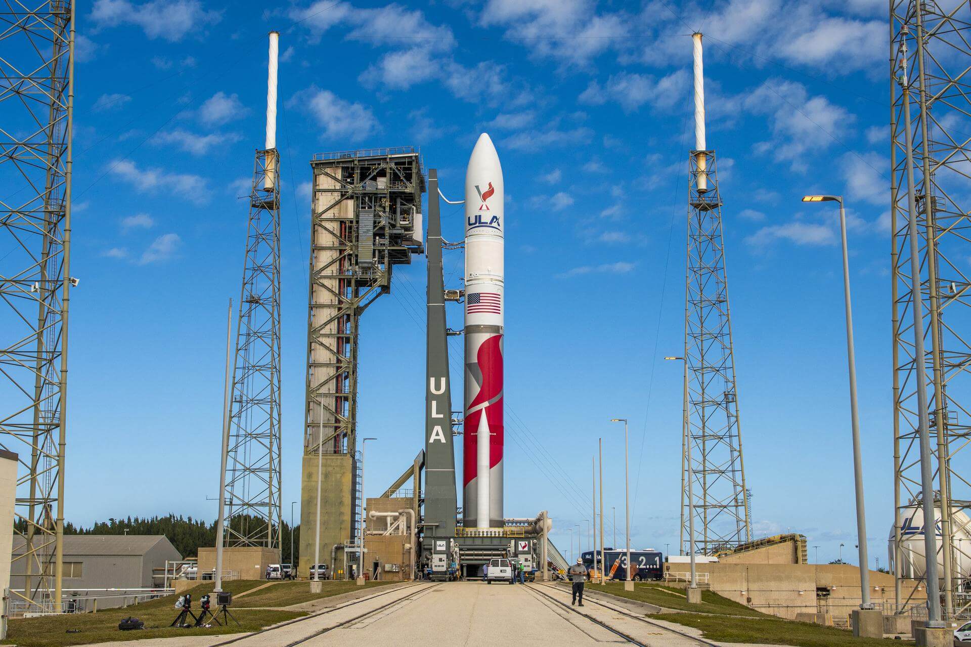
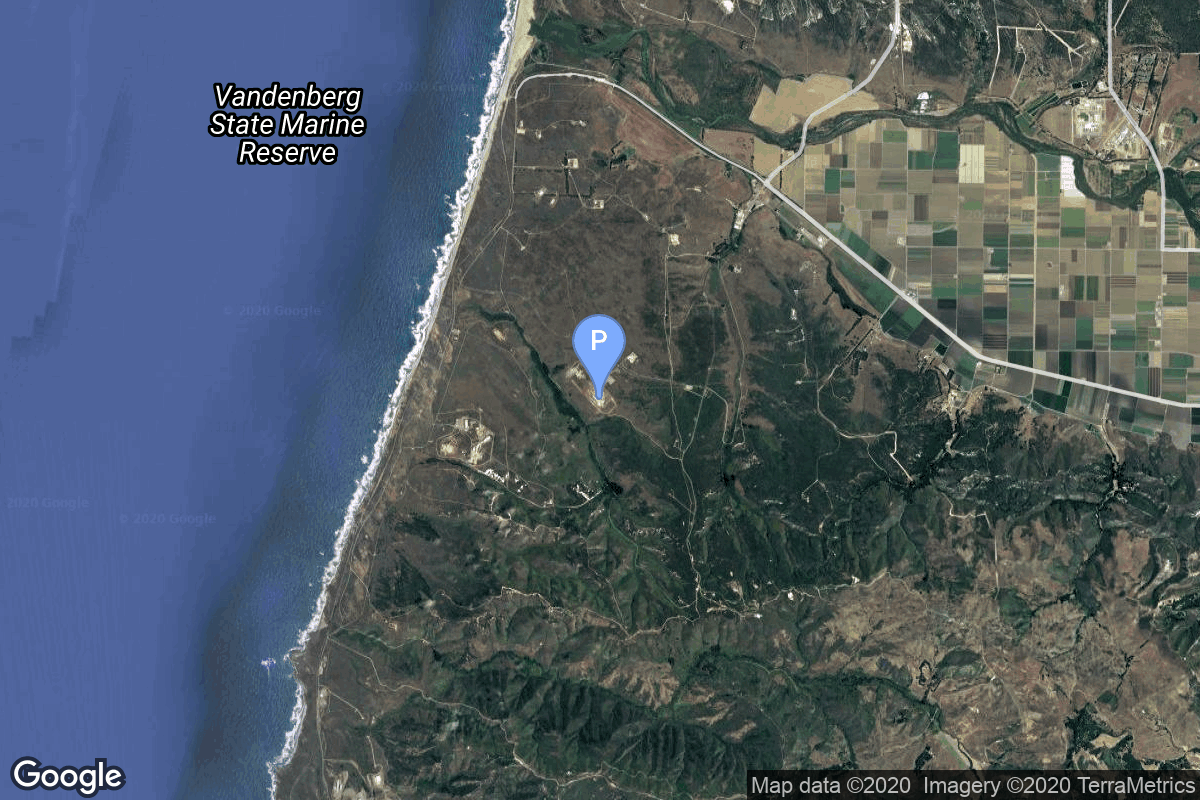
{ "count": 337, "next": "https://ll.thespacedevs.com/2.0.0/launch/upcoming/?format=api&limit=10&offset=314&ordering=name", "previous": "https://ll.thespacedevs.com/2.0.0/launch/upcoming/?format=api&limit=10&offset=294&ordering=name", "results": [ { "id": "d74f2e7b-a8b7-4d8f-8ecd-193e73937664", "url": "https://ll.thespacedevs.com/2.0.0/launch/d74f2e7b-a8b7-4d8f-8ecd-193e73937664/?format=api", "launch_library_id": 1947, "slug": "vega-c-space-rider", "name": "Vega-C | Space Rider", "status": { "id": 2, "name": "TBD" }, "net": "2027-12-31T00:00:00Z", "window_end": "2027-12-31T00:00:00Z", "window_start": "2027-12-31T00:00:00Z", "inhold": false, "tbdtime": true, "tbddate": true, "probability": null, "holdreason": "", "failreason": "", "hashtag": null, "launch_service_provider": { "id": 115, "url": "https://ll.thespacedevs.com/2.0.0/agencies/115/?format=api", "name": "Arianespace", "type": "Commercial" }, "rocket": { "id": 2491, "configuration": { "id": 127, "launch_library_id": 163, "url": "https://ll.thespacedevs.com/2.0.0/config/launcher/127/?format=api", "name": "Vega-C", "family": "Vega", "full_name": "Vega-C", "variant": "" } }, "mission": { "id": 6990, "launch_library_id": null, "name": "Space Rider", "description": "Maiden flight of the European Space Rider (Space Reusable Integrated Demonstrator for Europe Return).", "launch_designator": null, "type": "Technology", "orbit": { "id": 8, "name": "Low Earth Orbit", "abbrev": "LEO" } }, "pad": { "id": 34, "url": "https://ll.thespacedevs.com/2.0.0/pad/34/?format=api", "agency_id": 115, "name": "Ariane Launch Area 1 (ELV)", "info_url": null, "wiki_url": "https://en.wikipedia.org/wiki/ELA-1", "map_url": "https://www.google.com/maps?q=5.236,-52.775", "latitude": "5.236", "longitude": "-52.775", "location": { "id": 13, "url": "https://ll.thespacedevs.com/2.0.0/location/13/?format=api", "name": "Guiana Space Centre, French Guiana", "country_code": "GUF", "map_image": "https://thespacedevs-prod.nyc3.digitaloceanspaces.com/media/map_images/location_13_20200803142412.jpg", "total_launch_count": 325, "total_landing_count": 0 }, "map_image": "https://thespacedevs-prod.nyc3.digitaloceanspaces.com/media/map_images/pad_34_20200803143527.jpg", "total_launch_count": 52 }, "webcast_live": false, "image": "https://thespacedevs-prod.nyc3.digitaloceanspaces.com/media/images/vega-c_image_20220713154437.jpg", "infographic": null, "program": [] }, { "id": "8e6ca4d7-cd41-4659-af52-e2a01b9d8cd7", "url": "https://ll.thespacedevs.com/2.0.0/launch/8e6ca4d7-cd41-4659-af52-e2a01b9d8cd7/?format=api", "launch_library_id": null, "slug": "vega-c-truths", "name": "Vega-C | TRUTHS", "status": { "id": 2, "name": "TBD" }, "net": "2030-12-31T00:00:00Z", "window_end": "2030-12-31T00:00:00Z", "window_start": "2030-12-31T00:00:00Z", "inhold": false, "tbdtime": true, "tbddate": true, "probability": null, "holdreason": "", "failreason": "", "hashtag": null, "launch_service_provider": { "id": 115, "url": "https://ll.thespacedevs.com/2.0.0/agencies/115/?format=api", "name": "Arianespace", "type": "Commercial" }, "rocket": { "id": 8090, "configuration": { "id": 127, "launch_library_id": 163, "url": "https://ll.thespacedevs.com/2.0.0/config/launcher/127/?format=api", "name": "Vega-C", "family": "Vega", "full_name": "Vega-C", "variant": "" } }, "mission": { "id": 6644, "launch_library_id": null, "name": "TRUTHS", "description": "TRUTHS (Traceable Radiometry Underpinning Terrestrial- and Helio-Studies) is a a ‘standards laboratory in space’, setting the ‘gold standard’ reference for climate measurements. Carrying a cryogenic solar absolute radiometer and a hyperspectral imaging spectrometer as well as a novel onboard calibration system, TRUTHS is designed to make continuous measurements of incoming solar radiation and reflected radiation to evaluate Earth’s energy-in to energy-out ratio.", "launch_designator": null, "type": "Earth Science", "orbit": { "id": 17, "name": "Sun-Synchronous Orbit", "abbrev": "SSO" } }, "pad": { "id": 34, "url": "https://ll.thespacedevs.com/2.0.0/pad/34/?format=api", "agency_id": 115, "name": "Ariane Launch Area 1 (ELV)", "info_url": null, "wiki_url": "https://en.wikipedia.org/wiki/ELA-1", "map_url": "https://www.google.com/maps?q=5.236,-52.775", "latitude": "5.236", "longitude": "-52.775", "location": { "id": 13, "url": "https://ll.thespacedevs.com/2.0.0/location/13/?format=api", "name": "Guiana Space Centre, French Guiana", "country_code": "GUF", "map_image": "https://thespacedevs-prod.nyc3.digitaloceanspaces.com/media/map_images/location_13_20200803142412.jpg", "total_launch_count": 325, "total_landing_count": 0 }, "map_image": "https://thespacedevs-prod.nyc3.digitaloceanspaces.com/media/map_images/pad_34_20200803143527.jpg", "total_launch_count": 52 }, "webcast_live": false, "image": "https://thespacedevs-prod.nyc3.digitaloceanspaces.com/media/images/vega-c_image_20220713154437.jpg", "infographic": null, "program": [] }, { "id": "096e0a90-22f5-4323-a2a2-53eacde0371c", "url": "https://ll.thespacedevs.com/2.0.0/launch/096e0a90-22f5-4323-a2a2-53eacde0371c/?format=api", "launch_library_id": null, "slug": "vulcan-gps-iiif-sv01", "name": "Vulcan | GPS IIIF SV01", "status": { "id": 2, "name": "TBD" }, "net": "2026-12-31T00:00:00Z", "window_end": "2026-12-31T00:00:00Z", "window_start": "2026-12-31T00:00:00Z", "inhold": false, "tbdtime": true, "tbddate": true, "probability": null, "holdreason": "", "failreason": "", "hashtag": null, "launch_service_provider": { "id": 124, "url": "https://ll.thespacedevs.com/2.0.0/agencies/124/?format=api", "name": "United Launch Alliance", "type": "Commercial" }, "rocket": { "id": 8065, "configuration": { "id": 200, "launch_library_id": 226, "url": "https://ll.thespacedevs.com/2.0.0/config/launcher/200/?format=api", "name": "Vulcan", "family": "Vulcan", "full_name": "Vulcan", "variant": "Vulcan" } }, "mission": { "id": 6618, "launch_library_id": null, "name": "GPS IIIF SV01", "description": "First Block IIIF GPS satellite", "launch_designator": null, "type": "Navigation", "orbit": { "id": 12, "name": "Medium Earth Orbit", "abbrev": "MEO" } }, "pad": { "id": 29, "url": "https://ll.thespacedevs.com/2.0.0/pad/29/?format=api", "agency_id": null, "name": "Space Launch Complex 41", "info_url": null, "wiki_url": "https://en.wikipedia.org/wiki/Cape_Canaveral_Air_Force_Station_Space_Launch_Complex_41", "map_url": "https://www.google.com/maps?q=28.58341025,-80.58303644", "latitude": "28.58341025", "longitude": "-80.58303644", "location": { "id": 12, "url": "https://ll.thespacedevs.com/2.0.0/location/12/?format=api", "name": "Cape Canaveral SFS, FL, USA", "country_code": "USA", "map_image": "https://thespacedevs-prod.nyc3.digitaloceanspaces.com/media/map_images/location_12_20200803142519.jpg", "total_launch_count": 1020, "total_landing_count": 64 }, "map_image": "https://thespacedevs-prod.nyc3.digitaloceanspaces.com/media/map_images/pad_29_20200803143528.jpg", "total_launch_count": 115 }, "webcast_live": false, "image": "https://thespacedevs-prod.nyc3.digitaloceanspaces.com/media/images/vulcan_image_20240107162928.jpeg", "infographic": null, "program": [ { "id": 29, "url": "https://ll.thespacedevs.com/2.0.0/program/29/?format=api", "name": "Global Positioning System", "description": "The Global Positioning System (GPS), originally Navstar GPS, is a satellite-based radio navigation system owned by the United States government and operated by the United States Space Force. It is one of the global navigation satellite systems (GNSS) that provide geolocation and time information to a GPS receiver anywhere on or near the Earth where there is an unobstructed line of sight to four or more GPS satellites.", "agencies": [ { "id": 1041, "url": "https://ll.thespacedevs.com/2.0.0/agencies/1041/?format=api", "name": "United States Space Force", "type": "Government" } ], "image_url": "https://thespacedevs-prod.nyc3.digitaloceanspaces.com/media/images/global2520posi_program_20231229182501.png", "start_date": "1978-02-22T00:00:00Z", "end_date": null, "info_url": "https://www.gps.gov/", "wiki_url": "https://en.wikipedia.org/wiki/Global_Positioning_System" } ] }, { "id": "4c696af0-887c-4ff0-9f16-fed6bebd00bf", "url": "https://ll.thespacedevs.com/2.0.0/launch/4c696af0-887c-4ff0-9f16-fed6bebd00bf/?format=api", "launch_library_id": null, "slug": "vulcan-gps-iiif-sv02-ussf-49", "name": "Vulcan | GPS IIIF SV02 (USSF-49)", "status": { "id": 2, "name": "TBD" }, "net": "2029-12-31T00:00:00Z", "window_end": "2029-12-31T00:00:00Z", "window_start": "2029-12-31T00:00:00Z", "inhold": false, "tbdtime": true, "tbddate": true, "probability": null, "holdreason": "", "failreason": "", "hashtag": null, "launch_service_provider": { "id": 124, "url": "https://ll.thespacedevs.com/2.0.0/agencies/124/?format=api", "name": "United Launch Alliance", "type": "Commercial" }, "rocket": { "id": 8581, "configuration": { "id": 200, "launch_library_id": 226, "url": "https://ll.thespacedevs.com/2.0.0/config/launcher/200/?format=api", "name": "Vulcan", "family": "Vulcan", "full_name": "Vulcan", "variant": "Vulcan" } }, "mission": { "id": 7172, "launch_library_id": null, "name": "GPS IIIF SV02 (USSF-49)", "description": "Second Block IIIF GPS satellite", "launch_designator": null, "type": "Navigation", "orbit": { "id": 12, "name": "Medium Earth Orbit", "abbrev": "MEO" } }, "pad": { "id": 29, "url": "https://ll.thespacedevs.com/2.0.0/pad/29/?format=api", "agency_id": null, "name": "Space Launch Complex 41", "info_url": null, "wiki_url": "https://en.wikipedia.org/wiki/Cape_Canaveral_Air_Force_Station_Space_Launch_Complex_41", "map_url": "https://www.google.com/maps?q=28.58341025,-80.58303644", "latitude": "28.58341025", "longitude": "-80.58303644", "location": { "id": 12, "url": "https://ll.thespacedevs.com/2.0.0/location/12/?format=api", "name": "Cape Canaveral SFS, FL, USA", "country_code": "USA", "map_image": "https://thespacedevs-prod.nyc3.digitaloceanspaces.com/media/map_images/location_12_20200803142519.jpg", "total_launch_count": 1020, "total_landing_count": 64 }, "map_image": "https://thespacedevs-prod.nyc3.digitaloceanspaces.com/media/map_images/pad_29_20200803143528.jpg", "total_launch_count": 115 }, "webcast_live": false, "image": "https://thespacedevs-prod.nyc3.digitaloceanspaces.com/media/images/vulcan_image_20240107162928.jpeg", "infographic": null, "program": [ { "id": 29, "url": "https://ll.thespacedevs.com/2.0.0/program/29/?format=api", "name": "Global Positioning System", "description": "The Global Positioning System (GPS), originally Navstar GPS, is a satellite-based radio navigation system owned by the United States government and operated by the United States Space Force. It is one of the global navigation satellite systems (GNSS) that provide geolocation and time information to a GPS receiver anywhere on or near the Earth where there is an unobstructed line of sight to four or more GPS satellites.", "agencies": [ { "id": 1041, "url": "https://ll.thespacedevs.com/2.0.0/agencies/1041/?format=api", "name": "United States Space Force", "type": "Government" } ], "image_url": "https://thespacedevs-prod.nyc3.digitaloceanspaces.com/media/images/global2520posi_program_20231229182501.png", "start_date": "1978-02-22T00:00:00Z", "end_date": null, "info_url": "https://www.gps.gov/", "wiki_url": "https://en.wikipedia.org/wiki/Global_Positioning_System" } ] }, { "id": "98f70f28-397a-4c0d-aeb2-e7f8a88e0323", "url": "https://ll.thespacedevs.com/2.0.0/launch/98f70f28-397a-4c0d-aeb2-e7f8a88e0323/?format=api", "launch_library_id": null, "slug": "vulcan-gps-iii-sv09", "name": "Vulcan | GPS III SV09", "status": { "id": 2, "name": "TBD" }, "net": "2025-12-31T00:00:00Z", "window_end": "2025-12-31T00:00:00Z", "window_start": "2025-12-31T00:00:00Z", "inhold": false, "tbdtime": true, "tbddate": true, "probability": null, "holdreason": "", "failreason": "", "hashtag": null, "launch_service_provider": { "id": 124, "url": "https://ll.thespacedevs.com/2.0.0/agencies/124/?format=api", "name": "United Launch Alliance", "type": "Commercial" }, "rocket": { "id": 7899, "configuration": { "id": 200, "launch_library_id": 226, "url": "https://ll.thespacedevs.com/2.0.0/config/launcher/200/?format=api", "name": "Vulcan", "family": "Vulcan", "full_name": "Vulcan", "variant": "Vulcan" } }, "mission": { "id": 6408, "launch_library_id": null, "name": "GPS III SV09", "description": "Ninth of ten GPS III missions.", "launch_designator": null, "type": "Navigation", "orbit": { "id": 12, "name": "Medium Earth Orbit", "abbrev": "MEO" } }, "pad": { "id": 29, "url": "https://ll.thespacedevs.com/2.0.0/pad/29/?format=api", "agency_id": null, "name": "Space Launch Complex 41", "info_url": null, "wiki_url": "https://en.wikipedia.org/wiki/Cape_Canaveral_Air_Force_Station_Space_Launch_Complex_41", "map_url": "https://www.google.com/maps?q=28.58341025,-80.58303644", "latitude": "28.58341025", "longitude": "-80.58303644", "location": { "id": 12, "url": "https://ll.thespacedevs.com/2.0.0/location/12/?format=api", "name": "Cape Canaveral SFS, FL, USA", "country_code": "USA", "map_image": "https://thespacedevs-prod.nyc3.digitaloceanspaces.com/media/map_images/location_12_20200803142519.jpg", "total_launch_count": 1020, "total_landing_count": 64 }, "map_image": "https://thespacedevs-prod.nyc3.digitaloceanspaces.com/media/map_images/pad_29_20200803143528.jpg", "total_launch_count": 115 }, "webcast_live": false, "image": "https://thespacedevs-prod.nyc3.digitaloceanspaces.com/media/images/vulcan_image_20240107162928.jpeg", "infographic": null, "program": [ { "id": 29, "url": "https://ll.thespacedevs.com/2.0.0/program/29/?format=api", "name": "Global Positioning System", "description": "The Global Positioning System (GPS), originally Navstar GPS, is a satellite-based radio navigation system owned by the United States government and operated by the United States Space Force. It is one of the global navigation satellite systems (GNSS) that provide geolocation and time information to a GPS receiver anywhere on or near the Earth where there is an unobstructed line of sight to four or more GPS satellites.", "agencies": [ { "id": 1041, "url": "https://ll.thespacedevs.com/2.0.0/agencies/1041/?format=api", "name": "United States Space Force", "type": "Government" } ], "image_url": "https://thespacedevs-prod.nyc3.digitaloceanspaces.com/media/images/global2520posi_program_20231229182501.png", "start_date": "1978-02-22T00:00:00Z", "end_date": null, "info_url": "https://www.gps.gov/", "wiki_url": "https://en.wikipedia.org/wiki/Global_Positioning_System" } ] }, { "id": "2c5686ec-b0fd-4987-935d-587e3c85fa2d", "url": "https://ll.thespacedevs.com/2.0.0/launch/2c5686ec-b0fd-4987-935d-587e3c85fa2d/?format=api", "launch_library_id": null, "slug": "vulcan-gps-iii-sv10", "name": "Vulcan | GPS III SV10", "status": { "id": 2, "name": "TBD" }, "net": "2026-12-31T00:00:00Z", "window_end": "2026-12-31T00:00:00Z", "window_start": "2026-12-31T00:00:00Z", "inhold": false, "tbdtime": true, "tbddate": true, "probability": null, "holdreason": "", "failreason": "", "hashtag": null, "launch_service_provider": { "id": 124, "url": "https://ll.thespacedevs.com/2.0.0/agencies/124/?format=api", "name": "United Launch Alliance", "type": "Commercial" }, "rocket": { "id": 8060, "configuration": { "id": 200, "launch_library_id": 226, "url": "https://ll.thespacedevs.com/2.0.0/config/launcher/200/?format=api", "name": "Vulcan", "family": "Vulcan", "full_name": "Vulcan", "variant": "Vulcan" } }, "mission": { "id": 6613, "launch_library_id": null, "name": "GPS III SV10", "description": "Tenth of ten GPS III missions.", "launch_designator": null, "type": "Navigation", "orbit": { "id": 12, "name": "Medium Earth Orbit", "abbrev": "MEO" } }, "pad": { "id": 29, "url": "https://ll.thespacedevs.com/2.0.0/pad/29/?format=api", "agency_id": null, "name": "Space Launch Complex 41", "info_url": null, "wiki_url": "https://en.wikipedia.org/wiki/Cape_Canaveral_Air_Force_Station_Space_Launch_Complex_41", "map_url": "https://www.google.com/maps?q=28.58341025,-80.58303644", "latitude": "28.58341025", "longitude": "-80.58303644", "location": { "id": 12, "url": "https://ll.thespacedevs.com/2.0.0/location/12/?format=api", "name": "Cape Canaveral SFS, FL, USA", "country_code": "USA", "map_image": "https://thespacedevs-prod.nyc3.digitaloceanspaces.com/media/map_images/location_12_20200803142519.jpg", "total_launch_count": 1020, "total_landing_count": 64 }, "map_image": "https://thespacedevs-prod.nyc3.digitaloceanspaces.com/media/map_images/pad_29_20200803143528.jpg", "total_launch_count": 115 }, "webcast_live": false, "image": "https://thespacedevs-prod.nyc3.digitaloceanspaces.com/media/images/vulcan_image_20240107162928.jpeg", "infographic": null, "program": [ { "id": 29, "url": "https://ll.thespacedevs.com/2.0.0/program/29/?format=api", "name": "Global Positioning System", "description": "The Global Positioning System (GPS), originally Navstar GPS, is a satellite-based radio navigation system owned by the United States government and operated by the United States Space Force. It is one of the global navigation satellite systems (GNSS) that provide geolocation and time information to a GPS receiver anywhere on or near the Earth where there is an unobstructed line of sight to four or more GPS satellites.", "agencies": [ { "id": 1041, "url": "https://ll.thespacedevs.com/2.0.0/agencies/1041/?format=api", "name": "United States Space Force", "type": "Government" } ], "image_url": "https://thespacedevs-prod.nyc3.digitaloceanspaces.com/media/images/global2520posi_program_20231229182501.png", "start_date": "1978-02-22T00:00:00Z", "end_date": null, "info_url": "https://www.gps.gov/", "wiki_url": "https://en.wikipedia.org/wiki/Global_Positioning_System" } ] }, { "id": "6826ad67-c5a8-4293-868d-ab3d51b2bd6f", "url": "https://ll.thespacedevs.com/2.0.0/launch/6826ad67-c5a8-4293-868d-ab3d51b2bd6f/?format=api", "launch_library_id": null, "slug": "vulcan-ngg-2-ussf-50", "name": "Vulcan | NGG-2 (USSF-50)", "status": { "id": 2, "name": "TBD" }, "net": "2029-12-31T00:00:00Z", "window_end": "2029-12-31T00:00:00Z", "window_start": "2029-12-31T00:00:00Z", "inhold": false, "tbdtime": true, "tbddate": true, "probability": null, "holdreason": "", "failreason": "", "hashtag": null, "launch_service_provider": { "id": 124, "url": "https://ll.thespacedevs.com/2.0.0/agencies/124/?format=api", "name": "United Launch Alliance", "type": "Commercial" }, "rocket": { "id": 8580, "configuration": { "id": 200, "launch_library_id": 226, "url": "https://ll.thespacedevs.com/2.0.0/config/launcher/200/?format=api", "name": "Vulcan", "family": "Vulcan", "full_name": "Vulcan", "variant": "Vulcan" } }, "mission": { "id": 7171, "launch_library_id": null, "name": "NGG-2 (USSF-50)", "description": "Second Next-Generation Overhead Persistent Infrared GEO (NGG) satellite for the US Space Force. It is designed to deliver survivable, resilient missile warning, tracking, and defense.", "launch_designator": null, "type": "Government/Top Secret", "orbit": { "id": 25, "name": "Unknown", "abbrev": "N/A" } }, "pad": { "id": 29, "url": "https://ll.thespacedevs.com/2.0.0/pad/29/?format=api", "agency_id": null, "name": "Space Launch Complex 41", "info_url": null, "wiki_url": "https://en.wikipedia.org/wiki/Cape_Canaveral_Air_Force_Station_Space_Launch_Complex_41", "map_url": "https://www.google.com/maps?q=28.58341025,-80.58303644", "latitude": "28.58341025", "longitude": "-80.58303644", "location": { "id": 12, "url": "https://ll.thespacedevs.com/2.0.0/location/12/?format=api", "name": "Cape Canaveral SFS, FL, USA", "country_code": "USA", "map_image": "https://thespacedevs-prod.nyc3.digitaloceanspaces.com/media/map_images/location_12_20200803142519.jpg", "total_launch_count": 1020, "total_landing_count": 64 }, "map_image": "https://thespacedevs-prod.nyc3.digitaloceanspaces.com/media/map_images/pad_29_20200803143528.jpg", "total_launch_count": 115 }, "webcast_live": false, "image": "https://thespacedevs-prod.nyc3.digitaloceanspaces.com/media/images/vulcan_image_20240107162928.jpeg", "infographic": null, "program": [] }, { "id": "6f7eb79a-e288-494c-b122-730048df3440", "url": "https://ll.thespacedevs.com/2.0.0/launch/6f7eb79a-e288-494c-b122-730048df3440/?format=api", "launch_library_id": null, "slug": "vulcan-nrol-100", "name": "Vulcan | NROL-100", "status": { "id": 2, "name": "TBD" }, "net": "2026-12-31T00:00:00Z", "window_end": "2026-12-31T00:00:00Z", "window_start": "2026-12-31T00:00:00Z", "inhold": false, "tbdtime": true, "tbddate": true, "probability": null, "holdreason": "", "failreason": "", "hashtag": null, "launch_service_provider": { "id": 124, "url": "https://ll.thespacedevs.com/2.0.0/agencies/124/?format=api", "name": "United Launch Alliance", "type": "Commercial" }, "rocket": { "id": 8066, "configuration": { "id": 200, "launch_library_id": 226, "url": "https://ll.thespacedevs.com/2.0.0/config/launcher/200/?format=api", "name": "Vulcan", "family": "Vulcan", "full_name": "Vulcan", "variant": "Vulcan" } }, "mission": { "id": 6619, "launch_library_id": null, "name": "NROL-100", "description": "Classified payload for the US National Reconnaissance Office", "launch_designator": null, "type": "Government/Top Secret", "orbit": { "id": 25, "name": "Unknown", "abbrev": "N/A" } }, "pad": { "id": 24, "url": "https://ll.thespacedevs.com/2.0.0/pad/24/?format=api", "agency_id": 161, "name": "Space Launch Complex 3E", "info_url": null, "wiki_url": "https://en.wikipedia.org/wiki/Vandenberg_Space_Launch_Complex_3#SLC-3E", "map_url": "https://www.google.com/maps?q=34.64,-120.5895", "latitude": "34.64", "longitude": "-120.5895", "location": { "id": 11, "url": "https://ll.thespacedevs.com/2.0.0/location/11/?format=api", "name": "Vandenberg SFB, CA, USA", "country_code": "USA", "map_image": "https://thespacedevs-prod.nyc3.digitaloceanspaces.com/media/map_images/location_11_20200803142416.jpg", "total_launch_count": 804, "total_landing_count": 26 }, "map_image": "https://thespacedevs-prod.nyc3.digitaloceanspaces.com/media/map_images/pad_24_20200803143552.jpg", "total_launch_count": 48 }, "webcast_live": false, "image": "https://thespacedevs-prod.nyc3.digitaloceanspaces.com/media/images/vulcan_image_20240107162928.jpeg", "infographic": null, "program": [] }, { "id": "36570751-7492-4b06-81e6-4ac720071216", "url": "https://ll.thespacedevs.com/2.0.0/launch/36570751-7492-4b06-81e6-4ac720071216/?format=api", "launch_library_id": null, "slug": "vulcan-nrol-109", "name": "Vulcan | NROL-109", "status": { "id": 2, "name": "TBD" }, "net": "2026-12-31T00:00:00Z", "window_end": "2026-12-31T00:00:00Z", "window_start": "2026-12-31T00:00:00Z", "inhold": false, "tbdtime": true, "tbddate": true, "probability": null, "holdreason": "", "failreason": "", "hashtag": null, "launch_service_provider": { "id": 124, "url": "https://ll.thespacedevs.com/2.0.0/agencies/124/?format=api", "name": "United Launch Alliance", "type": "Commercial" }, "rocket": { "id": 8068, "configuration": { "id": 200, "launch_library_id": 226, "url": "https://ll.thespacedevs.com/2.0.0/config/launcher/200/?format=api", "name": "Vulcan", "family": "Vulcan", "full_name": "Vulcan", "variant": "Vulcan" } }, "mission": { "id": 6621, "launch_library_id": null, "name": "NROL-109", "description": "Classified payload for the US National Reconnaissance Office", "launch_designator": null, "type": "Government/Top Secret", "orbit": { "id": 25, "name": "Unknown", "abbrev": "N/A" } }, "pad": { "id": 29, "url": "https://ll.thespacedevs.com/2.0.0/pad/29/?format=api", "agency_id": null, "name": "Space Launch Complex 41", "info_url": null, "wiki_url": "https://en.wikipedia.org/wiki/Cape_Canaveral_Air_Force_Station_Space_Launch_Complex_41", "map_url": "https://www.google.com/maps?q=28.58341025,-80.58303644", "latitude": "28.58341025", "longitude": "-80.58303644", "location": { "id": 12, "url": "https://ll.thespacedevs.com/2.0.0/location/12/?format=api", "name": "Cape Canaveral SFS, FL, USA", "country_code": "USA", "map_image": "https://thespacedevs-prod.nyc3.digitaloceanspaces.com/media/map_images/location_12_20200803142519.jpg", "total_launch_count": 1020, "total_landing_count": 64 }, "map_image": "https://thespacedevs-prod.nyc3.digitaloceanspaces.com/media/map_images/pad_29_20200803143528.jpg", "total_launch_count": 115 }, "webcast_live": false, "image": "https://thespacedevs-prod.nyc3.digitaloceanspaces.com/media/images/vulcan_image_20240107162928.jpeg", "infographic": null, "program": [] }, { "id": "0a8cb805-3004-468e-bea6-743368af3253", "url": "https://ll.thespacedevs.com/2.0.0/launch/0a8cb805-3004-468e-bea6-743368af3253/?format=api", "launch_library_id": null, "slug": "vulcan-nrol-56", "name": "Vulcan | NROL-56", "status": { "id": 2, "name": "TBD" }, "net": "2026-12-31T00:00:00Z", "window_end": "2026-12-31T00:00:00Z", "window_start": "2026-12-31T00:00:00Z", "inhold": false, "tbdtime": true, "tbddate": true, "probability": null, "holdreason": "", "failreason": "", "hashtag": null, "launch_service_provider": { "id": 124, "url": "https://ll.thespacedevs.com/2.0.0/agencies/124/?format=api", "name": "United Launch Alliance", "type": "Commercial" }, "rocket": { "id": 8062, "configuration": { "id": 200, "launch_library_id": 226, "url": "https://ll.thespacedevs.com/2.0.0/config/launcher/200/?format=api", "name": "Vulcan", "family": "Vulcan", "full_name": "Vulcan", "variant": "Vulcan" } }, "mission": { "id": 6615, "launch_library_id": null, "name": "NROL-56", "description": "Classified payload for the US National Reconnaissance Office", "launch_designator": null, "type": "Government/Top Secret", "orbit": { "id": 25, "name": "Unknown", "abbrev": "N/A" } }, "pad": { "id": 29, "url": "https://ll.thespacedevs.com/2.0.0/pad/29/?format=api", "agency_id": null, "name": "Space Launch Complex 41", "info_url": null, "wiki_url": "https://en.wikipedia.org/wiki/Cape_Canaveral_Air_Force_Station_Space_Launch_Complex_41", "map_url": "https://www.google.com/maps?q=28.58341025,-80.58303644", "latitude": "28.58341025", "longitude": "-80.58303644", "location": { "id": 12, "url": "https://ll.thespacedevs.com/2.0.0/location/12/?format=api", "name": "Cape Canaveral SFS, FL, USA", "country_code": "USA", "map_image": "https://thespacedevs-prod.nyc3.digitaloceanspaces.com/media/map_images/location_12_20200803142519.jpg", "total_launch_count": 1020, "total_landing_count": 64 }, "map_image": "https://thespacedevs-prod.nyc3.digitaloceanspaces.com/media/map_images/pad_29_20200803143528.jpg", "total_launch_count": 115 }, "webcast_live": false, "image": "https://thespacedevs-prod.nyc3.digitaloceanspaces.com/media/images/vulcan_image_20240107162928.jpeg", "infographic": null, "program": [] } ] }