Launch List
API endpoint that returns all Launch objects or a single launch.
EXAMPLE - /launch/
GET: Return a list of all Launch objects.
FILTERS: Fields - 'name', 'id(s)', 'lsp_id', 'lsp_name', 'serial_number', 'launcher_config__id', 'rocket__spacecraftflight__spacecraft__name'
MODE: 'normal', 'list', 'detailed' EXAMPLE: ?mode=list
SEARCH: Searches through the launch name, rocket name, launch agency, mission name & spacecraft name. EXAMPLE - ?search=SpaceX
GET /2.0.0/launch/?format=api&offset=720&ordering=net
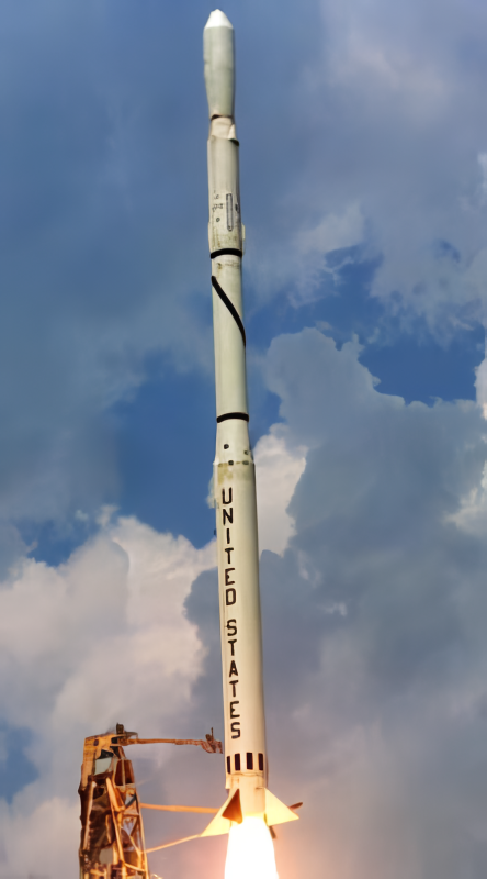
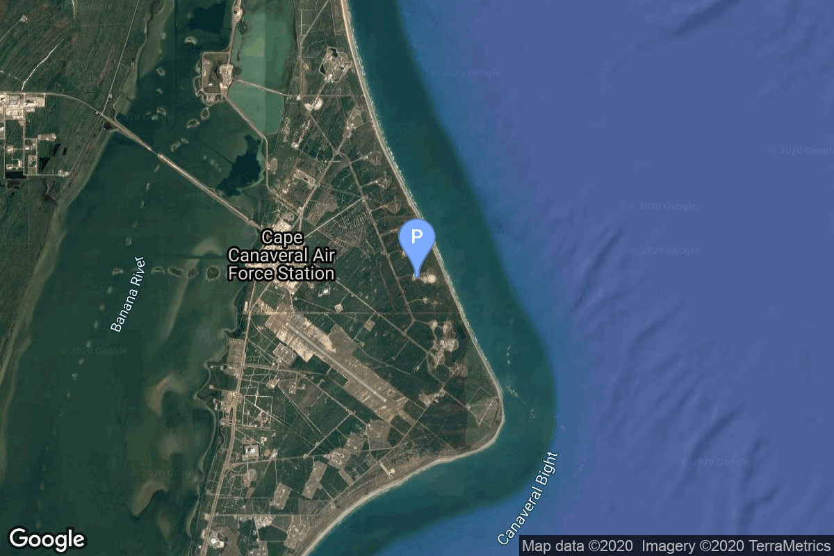
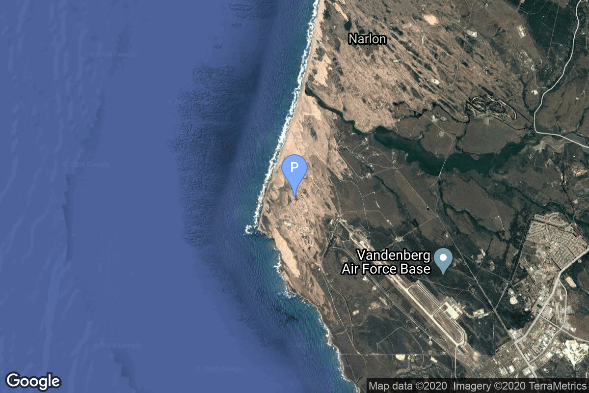
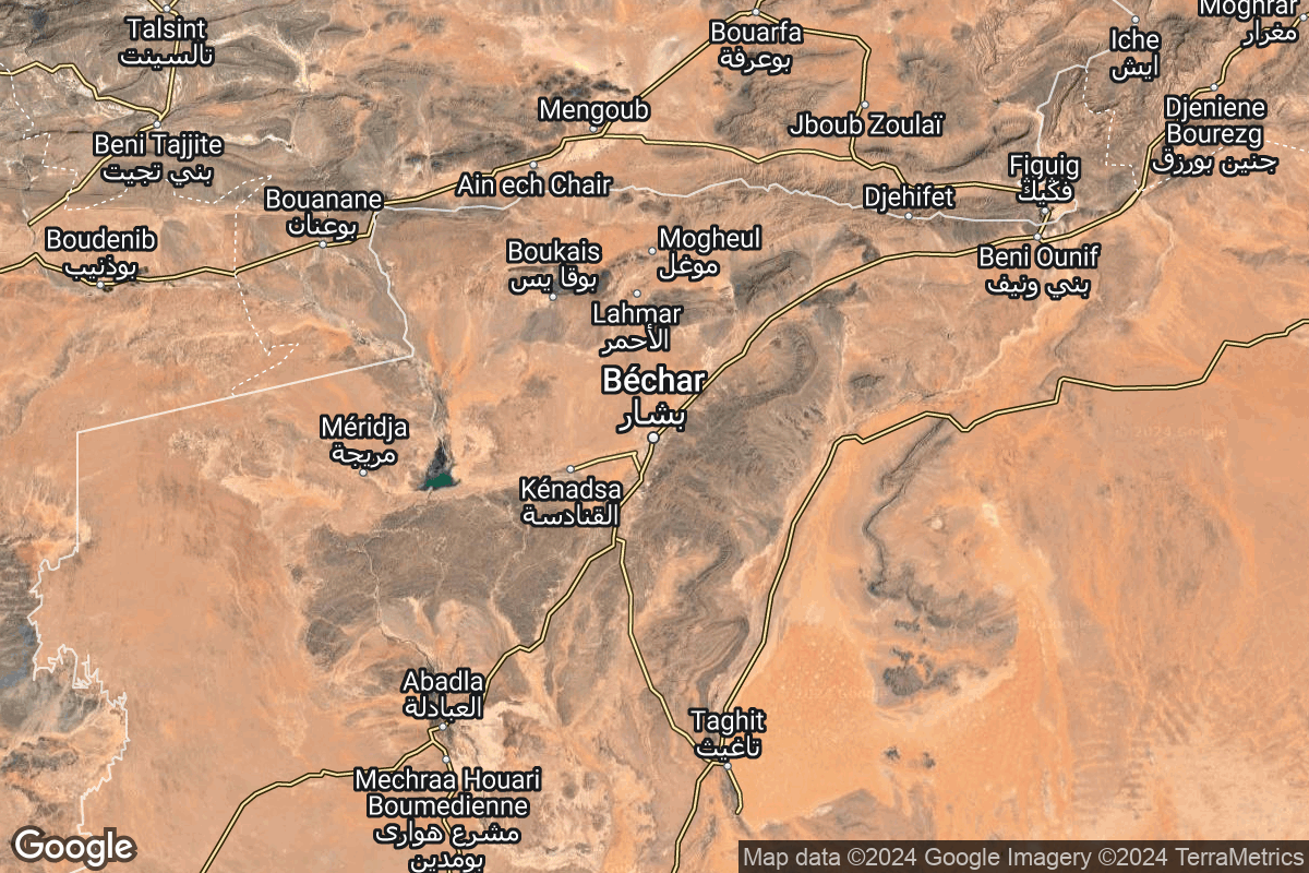
{ "count": 7859, "next": "https://ll.thespacedevs.com/2.0.0/launch/?format=api&limit=10&offset=730&ordering=net", "previous": "https://ll.thespacedevs.com/2.0.0/launch/?format=api&limit=10&offset=710&ordering=net", "results": [ { "id": "9c90ab75-9f49-4990-b343-8071e2626da3", "url": "https://ll.thespacedevs.com/2.0.0/launch/9c90ab75-9f49-4990-b343-8071e2626da3/?format=api", "launch_library_id": null, "slug": "scout-b-ov3-5", "name": "Scout B | OV3-5", "status": { "id": 4, "name": "Failure" }, "net": "1967-01-31T12:45:01Z", "window_end": "1967-01-31T12:45:01Z", "window_start": "1967-01-31T12:45:01Z", "inhold": false, "tbdtime": false, "tbddate": false, "probability": null, "holdreason": "", "failreason": null, "hashtag": null, "launch_service_provider": { "id": 161, "url": "https://ll.thespacedevs.com/2.0.0/agencies/161/?format=api", "name": "United States Air Force", "type": "Government" }, "rocket": { "id": 3615, "configuration": { "id": 358, "launch_library_id": null, "url": "https://ll.thespacedevs.com/2.0.0/config/launcher/358/?format=api", "name": "Scout B", "family": "Scout", "full_name": "Scout B", "variant": "B" } }, "mission": { "id": 2034, "launch_library_id": null, "name": "OV3-5", "description": "The OV3 (Orbiting Vehicle 3) series were experimental satellites based on an octagonal bus structure. These were the only in the OV series launched on dedicated launchers.", "launch_designator": null, "type": "Earth Science", "orbit": { "id": 13, "name": "Polar Orbit", "abbrev": "PO" } }, "pad": { "id": 154, "url": "https://ll.thespacedevs.com/2.0.0/pad/154/?format=api", "agency_id": null, "name": "Space Launch Complex 5", "info_url": "https://www.astronautix.com/v/vandenbergslc5.html", "wiki_url": "https://en.wikipedia.org/wiki/Vandenberg_Air_Force_Base_Space_Launch_Complex_5", "map_url": "https://www.google.com/maps?q=34.6080,-120.6247", "latitude": "34.608", "longitude": "-120.6247", "location": { "id": 11, "url": "https://ll.thespacedevs.com/2.0.0/location/11/?format=api", "name": "Vandenberg SFB, CA, USA", "country_code": "USA", "map_image": "https://thespacedevs-prod.nyc3.digitaloceanspaces.com/media/map_images/location_11_20200803142416.jpg", "total_launch_count": 883, "total_landing_count": 34 }, "map_image": "https://thespacedevs-prod.nyc3.digitaloceanspaces.com/media/map_images/pad_154_20200803143408.jpg", "total_launch_count": 69 }, "webcast_live": false, "image": "https://thespacedevs-prod.nyc3.digitaloceanspaces.com/media/images/scout-b_2528se_image_20251109064911.png", "infographic": null, "program": [] }, { "id": "a468a13f-1221-4438-92b4-7a87d18fb23a", "url": "https://ll.thespacedevs.com/2.0.0/launch/a468a13f-1221-4438-92b4-7a87d18fb23a/?format=api", "launch_library_id": null, "slug": "atlas-slv-3-agena-d-kh-7-36", "name": "Atlas SLV-3 Agena D | KH-7 36", "status": { "id": 3, "name": "Success" }, "net": "1967-02-02T20:00:00Z", "window_end": "1967-02-02T20:00:00Z", "window_start": "1967-02-02T20:00:00Z", "inhold": false, "tbdtime": false, "tbddate": false, "probability": null, "holdreason": "", "failreason": null, "hashtag": null, "launch_service_provider": { "id": 161, "url": "https://ll.thespacedevs.com/2.0.0/agencies/161/?format=api", "name": "United States Air Force", "type": "Government" }, "rocket": { "id": 3616, "configuration": { "id": 258, "launch_library_id": null, "url": "https://ll.thespacedevs.com/2.0.0/config/launcher/258/?format=api", "name": "Atlas SLV-3 Agena D", "family": "Atlas", "full_name": "Atlas SLV-3 Agena D", "variant": "SLV-3 Agena D" } }, "mission": { "id": 2035, "launch_library_id": null, "name": "KH-7 36", "description": "The Program 206 satellite, carrying the KH-7 (Keyhole 7) camera system (codenamed Gambit-1), was the first successful high resolution space reconnaissance program. It was managed by NRO's Program A, the USAF-led segment of the National Reconnaissance Program managed from Los Angeles AFB in El Segundo, California.", "launch_designator": null, "type": "Government/Top Secret", "orbit": { "id": 17, "name": "Sun-Synchronous Orbit", "abbrev": "SSO" } }, "pad": { "id": 16, "url": "https://ll.thespacedevs.com/2.0.0/pad/16/?format=api", "agency_id": null, "name": "Space Launch Complex 4E", "info_url": null, "wiki_url": "https://en.wikipedia.org/wiki/Vandenberg_Space_Launch_Complex_4#SLC-4E", "map_url": "https://www.google.com/maps?q=34.632,-120.611", "latitude": "34.632", "longitude": "-120.611", "location": { "id": 11, "url": "https://ll.thespacedevs.com/2.0.0/location/11/?format=api", "name": "Vandenberg SFB, CA, USA", "country_code": "USA", "map_image": "https://thespacedevs-prod.nyc3.digitaloceanspaces.com/media/map_images/location_11_20200803142416.jpg", "total_launch_count": 883, "total_landing_count": 34 }, "map_image": "https://thespacedevs-prod.nyc3.digitaloceanspaces.com/media/map_images/pad_16_20200803143532.jpg", "total_launch_count": 267 }, "webcast_live": false, "image": "https://thespacedevs-prod.nyc3.digitaloceanspaces.com/media/images/atlas-slv3_agen_image_20251102060811.jpg", "infographic": null, "program": [] }, { "id": "96fd4a72-a16a-4f32-8a04-4dc5b41917ab", "url": "https://ll.thespacedevs.com/2.0.0/launch/96fd4a72-a16a-4f32-8a04-4dc5b41917ab/?format=api", "launch_library_id": null, "slug": "atlas-slv-3-agena-d-lunar-orbiter-3", "name": "Atlas SLV-3 Agena D | Lunar Orbiter 3", "status": { "id": 3, "name": "Success" }, "net": "1967-02-05T01:17:01Z", "window_end": "1967-02-05T01:17:01Z", "window_start": "1967-02-05T01:17:01Z", "inhold": false, "tbdtime": false, "tbddate": false, "probability": null, "holdreason": "", "failreason": null, "hashtag": null, "launch_service_provider": { "id": 161, "url": "https://ll.thespacedevs.com/2.0.0/agencies/161/?format=api", "name": "United States Air Force", "type": "Government" }, "rocket": { "id": 3617, "configuration": { "id": 258, "launch_library_id": null, "url": "https://ll.thespacedevs.com/2.0.0/config/launcher/258/?format=api", "name": "Atlas SLV-3 Agena D", "family": "Atlas", "full_name": "Atlas SLV-3 Agena D", "variant": "SLV-3 Agena D" } }, "mission": { "id": 2036, "launch_library_id": null, "name": "Lunar Orbiter 3", "description": "Lunar probe designed to photograph the surface of the Moon with a resolution down to 1 meter.", "launch_designator": null, "type": "Lunar Exploration", "orbit": { "id": 11, "name": "Lunar Orbit", "abbrev": "LO" } }, "pad": { "id": 117, "url": "https://ll.thespacedevs.com/2.0.0/pad/117/?format=api", "agency_id": 161, "name": "Space Launch Complex 13", "info_url": null, "wiki_url": "https://en.wikipedia.org/wiki/Cape_Canaveral_Launch_Complex_13", "map_url": "https://www.google.com/maps?q=28.4859,-80.546594", "latitude": "28.4859", "longitude": "-80.546594", "location": { "id": 12, "url": "https://ll.thespacedevs.com/2.0.0/location/12/?format=api", "name": "Cape Canaveral SFS, FL, USA", "country_code": "USA", "map_image": "https://thespacedevs-prod.nyc3.digitaloceanspaces.com/media/map_images/location_12_20200803142519.jpg", "total_launch_count": 1106, "total_landing_count": 74 }, "map_image": "https://thespacedevs-prod.nyc3.digitaloceanspaces.com/media/map_images/pad_117_20200803143223.jpg", "total_launch_count": 21 }, "webcast_live": false, "image": "https://thespacedevs-prod.nyc3.digitaloceanspaces.com/media/images/atlas-slv3_agen_image_20251102060811.jpg", "infographic": null, "program": [] }, { "id": "330db032-2bfb-4b41-8bb2-219a5c254551", "url": "https://ll.thespacedevs.com/2.0.0/launch/330db032-2bfb-4b41-8bb2-219a5c254551/?format=api", "launch_library_id": 1918, "slug": "soyuz-kosmos-140", "name": "Soyuz | Kosmos 140", "status": { "id": 3, "name": "Success" }, "net": "1967-02-07T03:20:00Z", "window_end": "1967-02-07T03:20:00Z", "window_start": "1967-02-07T03:20:00Z", "inhold": false, "tbdtime": false, "tbddate": false, "probability": 0, "holdreason": "", "failreason": "", "hashtag": "", "launch_service_provider": { "id": 66, "url": "https://ll.thespacedevs.com/2.0.0/agencies/66/?format=api", "name": "Soviet Space Program", "type": "Government" }, "rocket": { "id": 2426, "configuration": { "id": 96, "launch_library_id": 134, "url": "https://ll.thespacedevs.com/2.0.0/config/launcher/96/?format=api", "name": "Soyuz", "family": "Soyuz", "full_name": "Soyuz", "variant": "" } }, "mission": null, "pad": { "id": 32, "url": "https://ll.thespacedevs.com/2.0.0/pad/32/?format=api", "agency_id": null, "name": "1/5", "info_url": null, "wiki_url": "", "map_url": "https://www.google.com/maps?q=45.92,63.342", "latitude": "45.92", "longitude": "63.342", "location": { "id": 15, "url": "https://ll.thespacedevs.com/2.0.0/location/15/?format=api", "name": "Baikonur Cosmodrome, Republic of Kazakhstan", "country_code": "KAZ", "map_image": "https://thespacedevs-prod.nyc3.digitaloceanspaces.com/media/map_images/location_15_20200803142517.jpg", "total_launch_count": 1563, "total_landing_count": 0 }, "map_image": "https://thespacedevs-prod.nyc3.digitaloceanspaces.com/media/map_images/pad_32_20200803143513.jpg", "total_launch_count": 487 }, "webcast_live": false, "image": null, "infographic": null, "program": [ { "id": 8, "url": "https://ll.thespacedevs.com/2.0.0/program/8/?format=api", "name": "Soyuz", "description": "The Soyuz programme is a human spaceflight programme initiated by the Soviet Union in the early 1960s. The Soyuz spacecraft was originally part of a Moon landing project intended to put a Soviet cosmonaut on the Moon. It was the third Soviet human spaceflight programme after the Vostok and Voskhod programmes.", "agencies": [ { "id": 63, "url": "https://ll.thespacedevs.com/2.0.0/agencies/63/?format=api", "name": "Russian Federal Space Agency (ROSCOSMOS)", "type": "Government" }, { "id": 66, "url": "https://ll.thespacedevs.com/2.0.0/agencies/66/?format=api", "name": "Soviet Space Program", "type": "Government" } ], "image_url": "https://thespacedevs-prod.nyc3.digitaloceanspaces.com/media/images/soyuz_program_20201129185543.png", "start_date": "1966-11-28T11:02:00Z", "end_date": null, "info_url": null, "wiki_url": "https://en.wikipedia.org/wiki/Soyuz_programme" } ] }, { "id": "4d16ea01-c26b-4099-a78c-1b5864a095d5", "url": "https://ll.thespacedevs.com/2.0.0/launch/4d16ea01-c26b-4099-a78c-1b5864a095d5/?format=api", "launch_library_id": null, "slug": "thor-burner-2-dsap-4a-f2", "name": "Thor Burner 2 | DSAP-4A F2", "status": { "id": 3, "name": "Success" }, "net": "1967-02-08T08:00:52Z", "window_end": "1967-02-08T08:00:52Z", "window_start": "1967-02-08T08:00:52Z", "inhold": false, "tbdtime": false, "tbddate": false, "probability": null, "holdreason": "", "failreason": null, "hashtag": null, "launch_service_provider": { "id": 161, "url": "https://ll.thespacedevs.com/2.0.0/agencies/161/?format=api", "name": "United States Air Force", "type": "Government" }, "rocket": { "id": 3618, "configuration": { "id": 395, "launch_library_id": null, "url": "https://ll.thespacedevs.com/2.0.0/config/launcher/395/?format=api", "name": "Thor Burner 2", "family": "Thor", "full_name": "Thor Burner 2", "variant": "Burner 2" } }, "mission": { "id": 2037, "launch_library_id": null, "name": "DSAP-4A F2", "description": "DSAP-4A (Defense Satellite Application Program Block 4A) was the fourth version of the military meteorological satellites of the Defense Meteorological Satellite Program.", "launch_designator": null, "type": "Earth Science", "orbit": { "id": 17, "name": "Sun-Synchronous Orbit", "abbrev": "SSO" } }, "pad": { "id": 171, "url": "https://ll.thespacedevs.com/2.0.0/pad/171/?format=api", "agency_id": null, "name": "Space Launch Complex 10W", "info_url": null, "wiki_url": "https://en.wikipedia.org/wiki/Vandenberg_Air_Force_Base_Space_Launch_Complex_10", "map_url": "https://www.google.com/maps?q=34.7652778,-120.6244162", "latitude": "34.7652778", "longitude": "-120.6244162", "location": { "id": 11, "url": "https://ll.thespacedevs.com/2.0.0/location/11/?format=api", "name": "Vandenberg SFB, CA, USA", "country_code": "USA", "map_image": "https://thespacedevs-prod.nyc3.digitaloceanspaces.com/media/map_images/location_11_20200803142416.jpg", "total_launch_count": 883, "total_landing_count": 34 }, "map_image": "https://thespacedevs-prod.nyc3.digitaloceanspaces.com/media/map_images/pad_171_20200803143449.jpg", "total_launch_count": 31 }, "webcast_live": false, "image": null, "infographic": null, "program": [] }, { "id": "c29dfe71-9741-4902-9fcd-4ccbf3741408", "url": "https://ll.thespacedevs.com/2.0.0/launch/c29dfe71-9741-4902-9fcd-4ccbf3741408/?format=api", "launch_library_id": null, "slug": "diamant-a-diademe-d-1c", "name": "Diamant A | Diademe D-1C", "status": { "id": 3, "name": "Success" }, "net": "1967-02-08T09:39:39Z", "window_end": "1967-02-08T09:39:39Z", "window_start": "1967-02-08T09:39:39Z", "inhold": false, "tbdtime": false, "tbddate": false, "probability": null, "holdreason": "", "failreason": null, "hashtag": null, "launch_service_provider": { "id": 46, "url": "https://ll.thespacedevs.com/2.0.0/agencies/46/?format=api", "name": "National Center of Space Research", "type": "Government" }, "rocket": { "id": 3619, "configuration": { "id": 311, "launch_library_id": null, "url": "https://ll.thespacedevs.com/2.0.0/config/launcher/311/?format=api", "name": "Diamant A", "family": "Diamant", "full_name": "Diamant A", "variant": "A" } }, "mission": { "id": 2038, "launch_library_id": null, "name": "Diademe D-1C", "description": "French geodetic study satellite.", "launch_designator": null, "type": "Earth Science", "orbit": { "id": 8, "name": "Low Earth Orbit", "abbrev": "LEO" } }, "pad": { "id": 141, "url": "https://ll.thespacedevs.com/2.0.0/pad/141/?format=api", "agency_id": null, "name": "Brigitte", "info_url": null, "wiki_url": "https://en.wikipedia.org/wiki/Hammaguir", "map_url": "https://www.google.com/maps?q=30.7787318,-3.0669721", "latitude": "30.7787318", "longitude": "-3.0669721", "location": { "id": 147, "url": "https://ll.thespacedevs.com/2.0.0/location/147/?format=api", "name": "Interarmy Special Vehicles Test Centre, French Algeria", "country_code": "FRA", "map_image": "https://thespacedevs-prod.nyc3.digitaloceanspaces.com/media/map_images/location_147_20240808092142.jpg", "total_launch_count": 4, "total_landing_count": 0 }, "map_image": "https://thespacedevs-prod.nyc3.digitaloceanspaces.com/media/map_images/pad_141_20200803143211.jpg", "total_launch_count": 4 }, "webcast_live": false, "image": "https://thespacedevs-prod.nyc3.digitaloceanspaces.com/media/images/diamant_a_lifto_image_20240411170731.png", "infographic": null, "program": [] }, { "id": "e4c48090-08c1-4914-9426-496851fd2493", "url": "https://ll.thespacedevs.com/2.0.0/launch/e4c48090-08c1-4914-9426-496851fd2493/?format=api", "launch_library_id": null, "slug": "voskhod-zenit-4-26", "name": "Voskhod | Zenit-4 26", "status": { "id": 3, "name": "Success" }, "net": "1967-02-08T10:19:59Z", "window_end": "1967-02-08T10:19:59Z", "window_start": "1967-02-08T10:19:59Z", "inhold": false, "tbdtime": false, "tbddate": false, "probability": null, "holdreason": "", "failreason": null, "hashtag": null, "launch_service_provider": { "id": 66, "url": "https://ll.thespacedevs.com/2.0.0/agencies/66/?format=api", "name": "Soviet Space Program", "type": "Government" }, "rocket": { "id": 3620, "configuration": { "id": 104, "launch_library_id": 138, "url": "https://ll.thespacedevs.com/2.0.0/config/launcher/104/?format=api", "name": "Voskhod", "family": "R-7", "full_name": "Voskhod", "variant": "Voskhod" } }, "mission": { "id": 2039, "launch_library_id": null, "name": "Zenit-4 26", "description": "Zenit-4 film-return reconnaissance satellite.", "launch_designator": null, "type": "Government/Top Secret", "orbit": { "id": 8, "name": "Low Earth Orbit", "abbrev": "LEO" } }, "pad": { "id": 168, "url": "https://ll.thespacedevs.com/2.0.0/pad/168/?format=api", "agency_id": null, "name": "41/1", "info_url": null, "wiki_url": "https://en.wikipedia.org/wiki/Plesetsk_Cosmodrome", "map_url": "https://www.google.com/maps?q=62.941,40.526806", "latitude": "62.941", "longitude": "40.526806", "location": { "id": 6, "url": "https://ll.thespacedevs.com/2.0.0/location/6/?format=api", "name": "Plesetsk Cosmodrome, Russian Federation", "country_code": "RUS", "map_image": "https://thespacedevs-prod.nyc3.digitaloceanspaces.com/media/map_images/location_6_20200803142434.jpg", "total_launch_count": 1685, "total_landing_count": 0 }, "map_image": "https://thespacedevs-prod.nyc3.digitaloceanspaces.com/media/map_images/pad_168_20200803143446.jpg", "total_launch_count": 310 }, "webcast_live": false, "image": "https://thespacedevs-prod.nyc3.digitaloceanspaces.com/media/images/voskhod_during__image_20251102062248.jpg", "infographic": null, "program": [] }, { "id": "8e5e8325-a40c-4d31-b790-f126a8f65877", "url": "https://ll.thespacedevs.com/2.0.0/launch/8e5e8325-a40c-4d31-b790-f126a8f65877/?format=api", "launch_library_id": null, "slug": "trailblazer-2-trailblazer-pellet-2", "name": "Trailblazer 2 | Trailblazer Pellet", "status": { "id": 3, "name": "Success" }, "net": "1967-02-14T05:52:00Z", "window_end": "1967-02-14T05:52:00Z", "window_start": "1967-02-14T05:52:00Z", "inhold": false, "tbdtime": false, "tbddate": false, "probability": null, "holdreason": "", "failreason": null, "hashtag": null, "launch_service_provider": { "id": 44, "url": "https://ll.thespacedevs.com/2.0.0/agencies/44/?format=api", "name": "National Aeronautics and Space Administration", "type": "Government" }, "rocket": { "id": 3621, "configuration": { "id": 442, "launch_library_id": null, "url": "https://ll.thespacedevs.com/2.0.0/config/launcher/442/?format=api", "name": "Trailblazer 2", "family": "Trailblazer", "full_name": "Trailblazer 2", "variant": "2" } }, "mission": { "id": 1922, "launch_library_id": null, "name": "Trailblazer Pellet", "description": "Suborbital launch to test re-entry systems. Reached an apogee of 280 km.", "launch_designator": null, "type": "Materials Science", "orbit": { "id": 15, "name": "Suborbital", "abbrev": "Sub" } }, "pad": { "id": 177, "url": "https://ll.thespacedevs.com/2.0.0/pad/177/?format=api", "agency_id": null, "name": "Unknown Pad", "info_url": null, "wiki_url": "https://en.wikipedia.org/wiki/Wallops_Flight_Facility", "map_url": "https://www.google.com/maps?q=37.9386111,-75.4594162", "latitude": "37.9386111", "longitude": "-75.4594162", "location": { "id": 21, "url": "https://ll.thespacedevs.com/2.0.0/location/21/?format=api", "name": "Wallops Flight Facility, Virginia, USA", "country_code": "USA", "map_image": "https://thespacedevs-prod.nyc3.digitaloceanspaces.com/media/map_images/location_21_20200803142423.jpg", "total_launch_count": 86, "total_landing_count": 0 }, "map_image": "https://thespacedevs-prod.nyc3.digitaloceanspaces.com/media/map_images/pad_177_20200803143406.jpg", "total_launch_count": 8 }, "webcast_live": false, "image": null, "infographic": null, "program": [] }, { "id": "eb4c291a-df93-4a59-9834-b0da9e8db916", "url": "https://ll.thespacedevs.com/2.0.0/launch/eb4c291a-df93-4a59-9834-b0da9e8db916/?format=api", "launch_library_id": null, "slug": "kosmos-11k63-ds-u2-i-2", "name": "Kosmos 11K63 | DS-U2-I 2", "status": { "id": 3, "name": "Success" }, "net": "1967-02-14T10:04:56Z", "window_end": "1967-02-14T10:04:56Z", "window_start": "1967-02-14T10:04:56Z", "inhold": false, "tbdtime": false, "tbddate": false, "probability": null, "holdreason": "", "failreason": null, "hashtag": null, "launch_service_provider": { "id": 66, "url": "https://ll.thespacedevs.com/2.0.0/agencies/66/?format=api", "name": "Soviet Space Program", "type": "Government" }, "rocket": { "id": 3622, "configuration": { "id": 327, "launch_library_id": null, "url": "https://ll.thespacedevs.com/2.0.0/config/launcher/327/?format=api", "name": "Kosmos 11K63", "family": "Kosmos", "full_name": "Kosmos 11K63", "variant": "11K63" } }, "mission": { "id": 2040, "launch_library_id": null, "name": "DS-U2-I 2", "description": "The DS-U2-I satellites were Soviet ionospheric research satellites launched as part of the Dnepropetrovsk Sputnik program.", "launch_designator": null, "type": "Earth Science", "orbit": { "id": 8, "name": "Low Earth Orbit", "abbrev": "LEO" } }, "pad": { "id": 139, "url": "https://ll.thespacedevs.com/2.0.0/pad/139/?format=api", "agency_id": null, "name": "86/1", "info_url": null, "wiki_url": "https://en.wikipedia.org/wiki/Kapustin_Yar", "map_url": "https://www.google.com/maps?q=48.56935,46.293219", "latitude": "48.56935", "longitude": "46.293219", "location": { "id": 30, "url": "https://ll.thespacedevs.com/2.0.0/location/30/?format=api", "name": "Kapustin Yar, Russian Federation", "country_code": "RUS", "map_image": "https://thespacedevs-prod.nyc3.digitaloceanspaces.com/media/map_images/location_30_20200803142515.jpg", "total_launch_count": 101, "total_landing_count": 0 }, "map_image": "https://thespacedevs-prod.nyc3.digitaloceanspaces.com/media/map_images/pad_139_20200803143345.jpg", "total_launch_count": 26 }, "webcast_live": false, "image": "https://thespacedevs-prod.nyc3.digitaloceanspaces.com/media/images/kosmos_11k63_image_20251104091702.jpg", "infographic": null, "program": [] }, { "id": "c5cd3db6-4b32-4cd9-a178-f3e04a9ed47f", "url": "https://ll.thespacedevs.com/2.0.0/launch/c5cd3db6-4b32-4cd9-a178-f3e04a9ed47f/?format=api", "launch_library_id": null, "slug": "diamant-a-diademe-d-1d", "name": "Diamant A | Diademe D-1D", "status": { "id": 3, "name": "Success" }, "net": "1967-02-15T10:06:57Z", "window_end": "1967-02-15T10:06:57Z", "window_start": "1967-02-15T10:06:57Z", "inhold": false, "tbdtime": false, "tbddate": false, "probability": null, "holdreason": "", "failreason": null, "hashtag": null, "launch_service_provider": { "id": 46, "url": "https://ll.thespacedevs.com/2.0.0/agencies/46/?format=api", "name": "National Center of Space Research", "type": "Government" }, "rocket": { "id": 3623, "configuration": { "id": 311, "launch_library_id": null, "url": "https://ll.thespacedevs.com/2.0.0/config/launcher/311/?format=api", "name": "Diamant A", "family": "Diamant", "full_name": "Diamant A", "variant": "A" } }, "mission": { "id": 2041, "launch_library_id": null, "name": "Diademe D-1D", "description": "French geodetic study satellite.", "launch_designator": null, "type": "Earth Science", "orbit": { "id": 8, "name": "Low Earth Orbit", "abbrev": "LEO" } }, "pad": { "id": 141, "url": "https://ll.thespacedevs.com/2.0.0/pad/141/?format=api", "agency_id": null, "name": "Brigitte", "info_url": null, "wiki_url": "https://en.wikipedia.org/wiki/Hammaguir", "map_url": "https://www.google.com/maps?q=30.7787318,-3.0669721", "latitude": "30.7787318", "longitude": "-3.0669721", "location": { "id": 147, "url": "https://ll.thespacedevs.com/2.0.0/location/147/?format=api", "name": "Interarmy Special Vehicles Test Centre, French Algeria", "country_code": "FRA", "map_image": "https://thespacedevs-prod.nyc3.digitaloceanspaces.com/media/map_images/location_147_20240808092142.jpg", "total_launch_count": 4, "total_landing_count": 0 }, "map_image": "https://thespacedevs-prod.nyc3.digitaloceanspaces.com/media/map_images/pad_141_20200803143211.jpg", "total_launch_count": 4 }, "webcast_live": false, "image": "https://thespacedevs-prod.nyc3.digitaloceanspaces.com/media/images/diamant_a_lifto_image_20240411170731.png", "infographic": null, "program": [] } ] }