Launch List
API endpoint that returns all Launch objects or a single launch.
EXAMPLE - /launch/
GET: Return a list of all Launch objects.
FILTERS: Fields - 'name', 'id(s)', 'lsp_id', 'lsp_name', 'serial_number', 'launcher_config__id', 'rocket__spacecraftflight__spacecraft__name'
MODE: 'normal', 'list', 'detailed' EXAMPLE: ?mode=list
SEARCH: Searches through the launch name, rocket name, launch agency, mission name & spacecraft name. EXAMPLE - ?search=SpaceX
GET /2.0.0/launch/?format=api&offset=7160&ordering=id
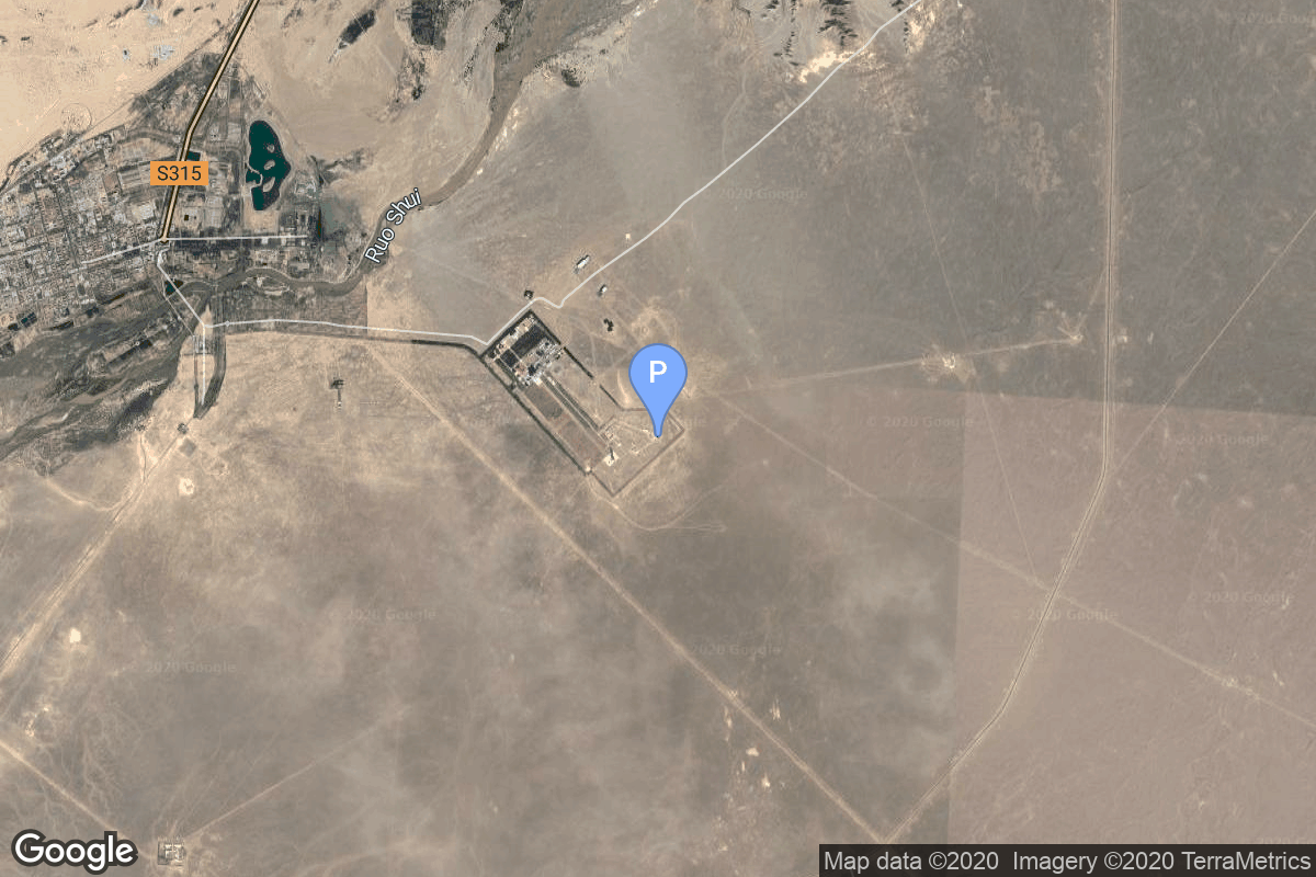
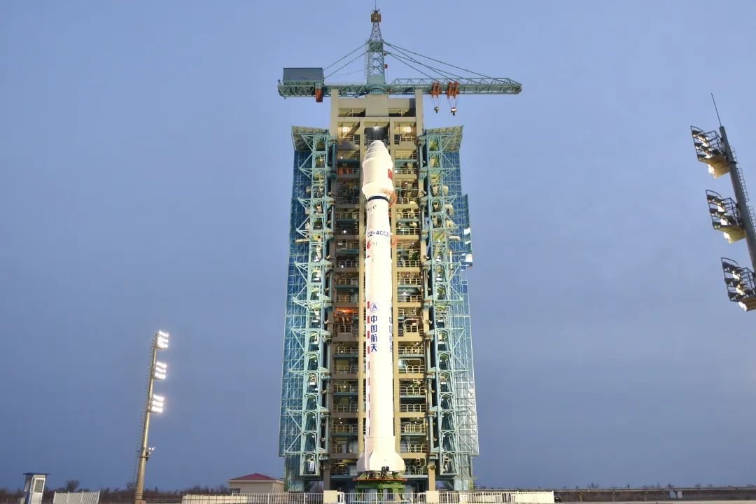
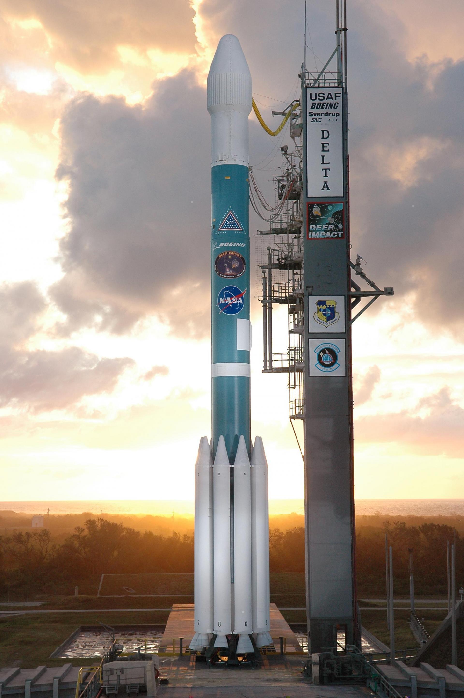
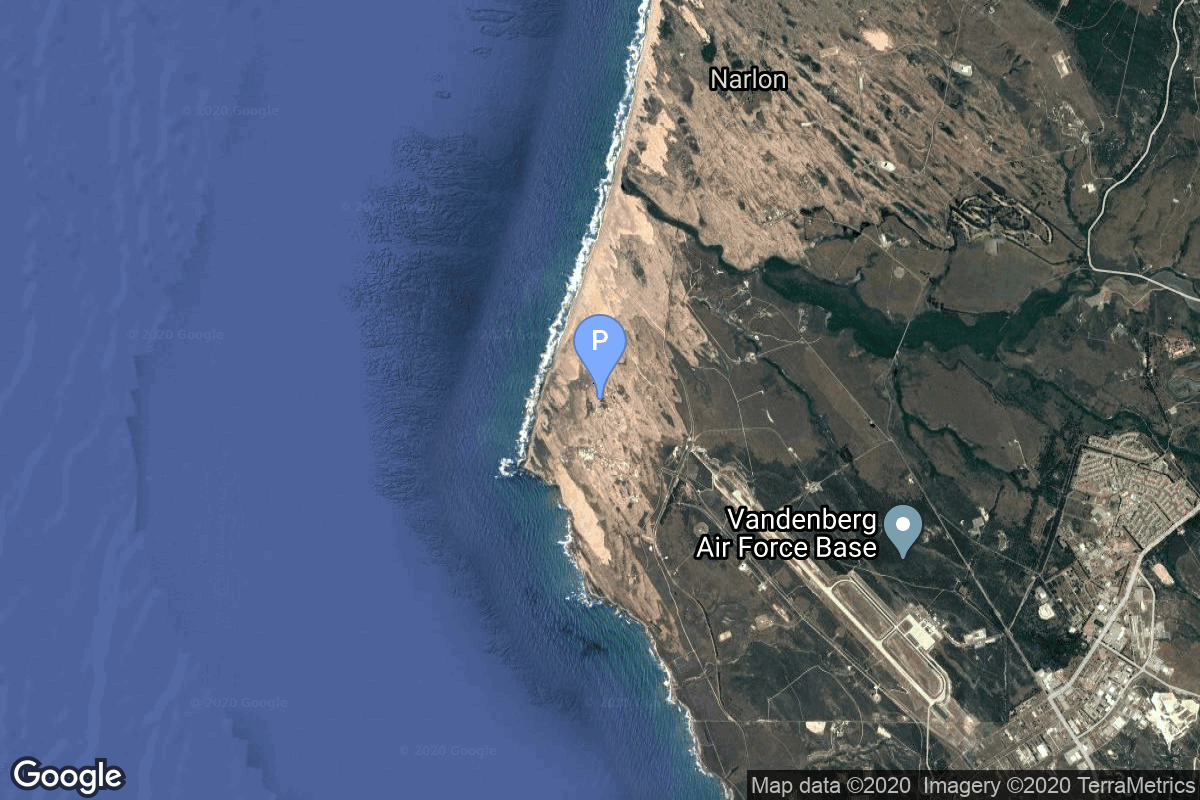
{ "count": 7494, "next": "https://ll.thespacedevs.com/2.0.0/launch/?format=api&limit=10&offset=7170&ordering=id", "previous": "https://ll.thespacedevs.com/2.0.0/launch/?format=api&limit=10&offset=7150&ordering=id", "results": [ { "id": "f3f92214-a75e-49c1-a460-bc23c573291b", "url": "https://ll.thespacedevs.com/2.0.0/launch/f3f92214-a75e-49c1-a460-bc23c573291b/?format=api", "launch_library_id": null, "slug": "long-march-4c-gaofen-12-02", "name": "Long March 4C | Gaofen-12-02", "status": { "id": 3, "name": "Success" }, "net": "2021-03-30T22:45:00Z", "window_end": "2021-03-30T22:59:00Z", "window_start": "2021-03-30T22:38:00Z", "inhold": false, "tbdtime": false, "tbddate": false, "probability": null, "holdreason": "", "failreason": "", "hashtag": null, "launch_service_provider": { "id": 88, "url": "https://ll.thespacedevs.com/2.0.0/agencies/88/?format=api", "name": "China Aerospace Science and Technology Corporation", "type": "Government" }, "rocket": { "id": 2848, "configuration": { "id": 64, "launch_library_id": 70, "url": "https://ll.thespacedevs.com/2.0.0/config/launcher/64/?format=api", "name": "Long March 4C", "family": "Long March", "full_name": "Long March 4C", "variant": "C" } }, "mission": { "id": 1262, "launch_library_id": null, "name": "Gaofen-12-02", "description": "Gaofen is a series of civilian Earth observation satellites developed and launched for the China High-definition Earth Observation System (CHEOS), a state-sponsored programme aimed to develop a near-real time, all-weather, global surveillance network consisting of satellite, near-space (stratosphere) airships, and aerial observation platforms.", "launch_designator": null, "type": "Earth Science", "orbit": { "id": 17, "name": "Sun-Synchronous Orbit", "abbrev": "SSO" } }, "pad": { "id": 22, "url": "https://ll.thespacedevs.com/2.0.0/pad/22/?format=api", "agency_id": null, "name": "Launch Area 4 (SLS-2 / 603)", "info_url": null, "wiki_url": "https://en.wikipedia.org/wiki/Jiuquan_Launch_Area_4", "map_url": "https://www.google.com/maps?q=40.960482,100.298059", "latitude": "40.960482", "longitude": "100.298059", "location": { "id": 17, "url": "https://ll.thespacedevs.com/2.0.0/location/17/?format=api", "name": "Jiuquan Satellite Launch Center, People's Republic of China", "country_code": "CHN", "map_image": "https://thespacedevs-prod.nyc3.digitaloceanspaces.com/media/map_images/location_17_20200803142429.jpg", "total_launch_count": 248, "total_landing_count": 0 }, "map_image": "https://thespacedevs-prod.nyc3.digitaloceanspaces.com/media/map_images/pad_22_20200803143437.jpg", "total_launch_count": 123 }, "webcast_live": false, "image": "https://thespacedevs-prod.nyc3.digitaloceanspaces.com/media/images/long_march_4c_image_20230801172338.jpeg", "infographic": null, "program": [] }, { "id": "f3f96691-7263-4ce4-b009-798eb44cf522", "url": "https://ll.thespacedevs.com/2.0.0/launch/f3f96691-7263-4ce4-b009-798eb44cf522/?format=api", "launch_library_id": null, "slug": "delta-ii-mugunghwa-1", "name": "Delta II | Mugunghwa 1", "status": { "id": 4, "name": "Failure" }, "net": "1995-08-05T11:10:00Z", "window_end": "1995-08-05T11:10:00Z", "window_start": "1995-08-05T11:10:00Z", "inhold": false, "tbdtime": false, "tbddate": false, "probability": null, "holdreason": "", "failreason": null, "hashtag": null, "launch_service_provider": { "id": 161, "url": "https://ll.thespacedevs.com/2.0.0/agencies/161/?format=api", "name": "United States Air Force", "type": "Government" }, "rocket": { "id": 6675, "configuration": { "id": 159, "launch_library_id": 179, "url": "https://ll.thespacedevs.com/2.0.0/config/launcher/159/?format=api", "name": "Delta II", "family": "Delta", "full_name": "Delta II 7925", "variant": "7925" } }, "mission": { "id": 5065, "launch_library_id": null, "name": "Mugunghwa 1", "description": "Koreasat 1 and 2, also known as Mugunghwa 1 and 2, were South Korean communications satellite launched by Delta-7925 rockets from Cape Canaveral. They were based on the Lockheed AS-3000 bus and carried 15 Ku-band transponders to provide TV coverage for South Korea and other Asian countries.", "launch_designator": null, "type": "Communications", "orbit": { "id": 1, "name": "Geostationary Orbit", "abbrev": "Direct-GEO" } }, "pad": { "id": 1, "url": "https://ll.thespacedevs.com/2.0.0/pad/1/?format=api", "agency_id": null, "name": "Space Launch Complex 17B", "info_url": null, "wiki_url": "https://en.wikipedia.org/wiki/Cape_Canaveral_Space_Launch_Complex_17", "map_url": "https://www.google.com/maps?q=28.4458,-80.5657", "latitude": "28.4458", "longitude": "-80.5657", "location": { "id": 12, "url": "https://ll.thespacedevs.com/2.0.0/location/12/?format=api", "name": "Cape Canaveral SFS, FL, USA", "country_code": "USA", "map_image": "https://thespacedevs-prod.nyc3.digitaloceanspaces.com/media/map_images/location_12_20200803142519.jpg", "total_launch_count": 1022, "total_landing_count": 64 }, "map_image": "https://thespacedevs-prod.nyc3.digitaloceanspaces.com/media/map_images/pad_1_20200803143208.jpg", "total_launch_count": 132 }, "webcast_live": false, "image": "https://thespacedevs-prod.nyc3.digitaloceanspaces.com/media/images/delta2520ii_image_20190222030440.jpeg", "infographic": null, "program": [] }, { "id": "f41041ad-37bf-4b23-b1c2-80ecca7ea25e", "url": "https://ll.thespacedevs.com/2.0.0/launch/f41041ad-37bf-4b23-b1c2-80ecca7ea25e/?format=api", "launch_library_id": null, "slug": "thor-slv-2a-agena-d-kh-4a-29", "name": "Thor SLV-2A Agena D | KH-4A 29", "status": { "id": 3, "name": "Success" }, "net": "1966-02-02T21:32:13Z", "window_end": "1966-02-02T21:32:13Z", "window_start": "1966-02-02T21:32:13Z", "inhold": false, "tbdtime": false, "tbddate": false, "probability": null, "holdreason": "", "failreason": null, "hashtag": null, "launch_service_provider": { "id": 161, "url": "https://ll.thespacedevs.com/2.0.0/agencies/161/?format=api", "name": "United States Air Force", "type": "Government" }, "rocket": { "id": 3484, "configuration": { "id": 417, "launch_library_id": null, "url": "https://ll.thespacedevs.com/2.0.0/config/launcher/417/?format=api", "name": "Thor SLV-2A Agena D", "family": "Thor", "full_name": "Thor SLV-2A Agena D", "variant": "SLV-2A Agena D" } }, "mission": { "id": 1904, "launch_library_id": null, "name": "KH-4A 29", "description": "The KH-4A (Keyhole-4A) was the fifth optical reconnaissance satellite version in the Corona-program.", "launch_designator": null, "type": "Government/Top Secret", "orbit": { "id": 8, "name": "Low Earth Orbit", "abbrev": "LEO" } }, "pad": { "id": 93, "url": "https://ll.thespacedevs.com/2.0.0/pad/93/?format=api", "agency_id": 161, "name": "Space Launch Complex 3W", "info_url": null, "wiki_url": "https://en.wikipedia.org/wiki/Vandenberg_Space_Launch_Complex_3#SLC-3W", "map_url": "https://www.google.com/maps?q=34.644,-120.593", "latitude": "34.644", "longitude": "-120.593", "location": { "id": 11, "url": "https://ll.thespacedevs.com/2.0.0/location/11/?format=api", "name": "Vandenberg SFB, CA, USA", "country_code": "USA", "map_image": "https://thespacedevs-prod.nyc3.digitaloceanspaces.com/media/map_images/location_11_20200803142416.jpg", "total_launch_count": 806, "total_landing_count": 26 }, "map_image": "https://thespacedevs-prod.nyc3.digitaloceanspaces.com/media/map_images/pad_93_20200803143225.jpg", "total_launch_count": 81 }, "webcast_live": false, "image": null, "infographic": null, "program": [] }, { "id": "f419160c-f4b7-456b-8b88-7df84ce1291f", "url": "https://ll.thespacedevs.com/2.0.0/launch/f419160c-f4b7-456b-8b88-7df84ce1291f/?format=api", "launch_library_id": null, "slug": "thor-burner-1-dsap-2-f2", "name": "Thor Burner 1 | DSAP-2 F2", "status": { "id": 4, "name": "Failure" }, "net": "1966-01-07T04:48:23Z", "window_end": "1966-01-07T04:48:23Z", "window_start": "1966-01-07T04:48:23Z", "inhold": false, "tbdtime": false, "tbddate": false, "probability": null, "holdreason": "", "failreason": null, "hashtag": null, "launch_service_provider": { "id": 161, "url": "https://ll.thespacedevs.com/2.0.0/agencies/161/?format=api", "name": "United States Air Force", "type": "Government" }, "rocket": { "id": 3477, "configuration": { "id": 394, "launch_library_id": null, "url": "https://ll.thespacedevs.com/2.0.0/config/launcher/394/?format=api", "name": "Thor Burner 1", "family": "Thor", "full_name": "Thor Burner 1", "variant": "Burner 1" } }, "mission": { "id": 1897, "launch_library_id": null, "name": "DSAP-2 F2", "description": "The DSAP-2 (Defense Satellite Application Program Block 2) satellites series consisted of three modified DSAP-1 military meteorological satellites.", "launch_designator": null, "type": "Government/Top Secret", "orbit": { "id": 17, "name": "Sun-Synchronous Orbit", "abbrev": "SSO" } }, "pad": { "id": 171, "url": "https://ll.thespacedevs.com/2.0.0/pad/171/?format=api", "agency_id": null, "name": "Space Launch Complex 10W", "info_url": null, "wiki_url": "https://en.wikipedia.org/wiki/Vandenberg_Air_Force_Base_Space_Launch_Complex_10", "map_url": "https://www.google.com/maps?q=34.7652778,-120.6244162", "latitude": "34.7652778", "longitude": "-120.6244162", "location": { "id": 11, "url": "https://ll.thespacedevs.com/2.0.0/location/11/?format=api", "name": "Vandenberg SFB, CA, USA", "country_code": "USA", "map_image": "https://thespacedevs-prod.nyc3.digitaloceanspaces.com/media/map_images/location_11_20200803142416.jpg", "total_launch_count": 806, "total_landing_count": 26 }, "map_image": "https://thespacedevs-prod.nyc3.digitaloceanspaces.com/media/map_images/pad_171_20200803143449.jpg", "total_launch_count": 31 }, "webcast_live": false, "image": null, "infographic": null, "program": [] }, { "id": "f419a025-62f7-4f48-ae68-4cacc95583d0", "url": "https://ll.thespacedevs.com/2.0.0/launch/f419a025-62f7-4f48-ae68-4cacc95583d0/?format=api", "launch_library_id": null, "slug": "delta-3920pam-palapa-b2p", "name": "Delta 3920/PAM | Palapa B2P", "status": { "id": 3, "name": "Success" }, "net": "1987-03-20T22:22:00Z", "window_end": "1987-03-20T22:22:00Z", "window_start": "1987-03-20T22:22:00Z", "inhold": false, "tbdtime": false, "tbddate": false, "probability": null, "holdreason": "", "failreason": null, "hashtag": null, "launch_service_provider": { "id": 161, "url": "https://ll.thespacedevs.com/2.0.0/agencies/161/?format=api", "name": "United States Air Force", "type": "Government" }, "rocket": { "id": 5951, "configuration": { "id": 294, "launch_library_id": null, "url": "https://ll.thespacedevs.com/2.0.0/config/launcher/294/?format=api", "name": "Delta 3920/PAM", "family": "Delta", "full_name": "Delta 3920/PAM", "variant": "3920/PAM" } }, "mission": { "id": 4345, "launch_library_id": null, "name": "Palapa B2P", "description": "Indonesian geostationary communications satellite", "launch_designator": null, "type": "Communications", "orbit": { "id": 1, "name": "Geostationary Orbit", "abbrev": "Direct-GEO" } }, "pad": { "id": 1, "url": "https://ll.thespacedevs.com/2.0.0/pad/1/?format=api", "agency_id": null, "name": "Space Launch Complex 17B", "info_url": null, "wiki_url": "https://en.wikipedia.org/wiki/Cape_Canaveral_Space_Launch_Complex_17", "map_url": "https://www.google.com/maps?q=28.4458,-80.5657", "latitude": "28.4458", "longitude": "-80.5657", "location": { "id": 12, "url": "https://ll.thespacedevs.com/2.0.0/location/12/?format=api", "name": "Cape Canaveral SFS, FL, USA", "country_code": "USA", "map_image": "https://thespacedevs-prod.nyc3.digitaloceanspaces.com/media/map_images/location_12_20200803142519.jpg", "total_launch_count": 1022, "total_landing_count": 64 }, "map_image": "https://thespacedevs-prod.nyc3.digitaloceanspaces.com/media/map_images/pad_1_20200803143208.jpg", "total_launch_count": 132 }, "webcast_live": false, "image": "https://thespacedevs-prod.nyc3.digitaloceanspaces.com/media/images/delta_3910_image_20231231105538.jpeg", "infographic": null, "program": [] }, { "id": "f426601c-4740-4980-9adb-4f6ab71e85d6", "url": "https://ll.thespacedevs.com/2.0.0/launch/f426601c-4740-4980-9adb-4f6ab71e85d6/?format=api", "launch_library_id": null, "slug": "delta-3920-8-delta-star", "name": "Delta 3920-8 | Delta Star", "status": { "id": 3, "name": "Success" }, "net": "1989-03-24T21:50:49Z", "window_end": "1989-03-24T21:50:49Z", "window_start": "1989-03-24T21:50:49Z", "inhold": false, "tbdtime": false, "tbddate": false, "probability": null, "holdreason": "", "failreason": null, "hashtag": null, "launch_service_provider": { "id": 161, "url": "https://ll.thespacedevs.com/2.0.0/agencies/161/?format=api", "name": "United States Air Force", "type": "Government" }, "rocket": { "id": 6162, "configuration": { "id": 293, "launch_library_id": null, "url": "https://ll.thespacedevs.com/2.0.0/config/launcher/293/?format=api", "name": "Delta 3920-8", "family": "Delta", "full_name": "Delta 3920-8", "variant": "3920-8" } }, "mission": { "id": 4552, "launch_library_id": null, "name": "Delta Star", "description": "SDI experiment", "launch_designator": null, "type": "Government/Top Secret", "orbit": { "id": 8, "name": "Low Earth Orbit", "abbrev": "LEO" } }, "pad": { "id": 1, "url": "https://ll.thespacedevs.com/2.0.0/pad/1/?format=api", "agency_id": null, "name": "Space Launch Complex 17B", "info_url": null, "wiki_url": "https://en.wikipedia.org/wiki/Cape_Canaveral_Space_Launch_Complex_17", "map_url": "https://www.google.com/maps?q=28.4458,-80.5657", "latitude": "28.4458", "longitude": "-80.5657", "location": { "id": 12, "url": "https://ll.thespacedevs.com/2.0.0/location/12/?format=api", "name": "Cape Canaveral SFS, FL, USA", "country_code": "USA", "map_image": "https://thespacedevs-prod.nyc3.digitaloceanspaces.com/media/map_images/location_12_20200803142519.jpg", "total_launch_count": 1022, "total_landing_count": 64 }, "map_image": "https://thespacedevs-prod.nyc3.digitaloceanspaces.com/media/map_images/pad_1_20200803143208.jpg", "total_launch_count": 132 }, "webcast_live": false, "image": "https://thespacedevs-prod.nyc3.digitaloceanspaces.com/media/images/delta_3910_image_20231231105538.jpeg", "infographic": null, "program": [] }, { "id": "f42a5c29-24bf-4813-8f78-42ee31695ea7", "url": "https://ll.thespacedevs.com/2.0.0/launch/f42a5c29-24bf-4813-8f78-42ee31695ea7/?format=api", "launch_library_id": 844, "slug": "ariane-5-eca-eutelsat-w3b-bsat-3b", "name": "Ariane 5 ECA | Eutelsat W3B & BSAT-3b", "status": { "id": 3, "name": "Success" }, "net": "2010-10-28T21:51:00Z", "window_end": "2010-10-28T21:51:00Z", "window_start": "2010-10-28T21:51:00Z", "inhold": false, "tbdtime": false, "tbddate": false, "probability": -1, "holdreason": "", "failreason": null, "hashtag": null, "launch_service_provider": { "id": 115, "url": "https://ll.thespacedevs.com/2.0.0/agencies/115/?format=api", "name": "Arianespace", "type": "Commercial" }, "rocket": { "id": 679, "configuration": { "id": 20, "launch_library_id": 27, "url": "https://ll.thespacedevs.com/2.0.0/config/launcher/20/?format=api", "name": "Ariane 5 ECA", "family": "Ariane", "full_name": "Ariane 5 ECA", "variant": "ECA" } }, "mission": { "id": 805, "launch_library_id": 805, "name": "Eutelsat W3B & BSAT-3b", "description": "Eutelsat W3B is a communication satellite to be located at 7 degrees East to provide broadcast and telecommunications accross Europe, the Middle East and Africa. However it took another satellites place, W2M which had failed. Directly after launch however W3B developed a sizeable leak and was declared a total loss. B-SAT 3b is a geostationary communications satellite operated by B-SAT stationed at 110 degrees East, providing high definition direct television services across Japan.", "launch_designator": null, "type": "Communications", "orbit": { "id": 2, "name": "Geostationary Transfer Orbit", "abbrev": "GTO" } }, "pad": { "id": 77, "url": "https://ll.thespacedevs.com/2.0.0/pad/77/?format=api", "agency_id": 115, "name": "Ariane Launch Area 3", "info_url": null, "wiki_url": "http://en.wikipedia.org/wiki/ELA-3", "map_url": "https://www.google.com/maps?q=5.239,-52.768", "latitude": "5.239", "longitude": "-52.768", "location": { "id": 13, "url": "https://ll.thespacedevs.com/2.0.0/location/13/?format=api", "name": "Guiana Space Centre, French Guiana", "country_code": "GUF", "map_image": "https://thespacedevs-prod.nyc3.digitaloceanspaces.com/media/map_images/location_13_20200803142412.jpg", "total_launch_count": 325, "total_landing_count": 0 }, "map_image": "https://thespacedevs-prod.nyc3.digitaloceanspaces.com/media/map_images/pad_77_20200803143458.jpg", "total_launch_count": 118 }, "webcast_live": false, "image": "https://thespacedevs-prod.nyc3.digitaloceanspaces.com/media/images/ariane252052520eca_image_20190224012333.jpeg", "infographic": null, "program": [] }, { "id": "f42d7a3e-d5e0-4f60-b323-3da58334575c", "url": "https://ll.thespacedevs.com/2.0.0/launch/f42d7a3e-d5e0-4f60-b323-3da58334575c/?format=api", "launch_library_id": null, "slug": "mu-3h-jikiken", "name": "Mu-3H | Jikiken", "status": { "id": 3, "name": "Success" }, "net": "1978-09-16T05:00:00Z", "window_end": "1978-09-16T05:00:00Z", "window_start": "1978-09-16T05:00:00Z", "inhold": false, "tbdtime": false, "tbddate": false, "probability": null, "holdreason": "", "failreason": null, "hashtag": null, "launch_service_provider": { "id": 1009, "url": "https://ll.thespacedevs.com/2.0.0/agencies/1009/?format=api", "name": "Institute of Space and Astronautical Science", "type": "Government" }, "rocket": { "id": 4996, "configuration": { "id": 337, "launch_library_id": null, "url": "https://ll.thespacedevs.com/2.0.0/config/launcher/337/?format=api", "name": "Mu-3H", "family": "Mu", "full_name": "Mu-3H", "variant": "H" } }, "mission": { "id": 3410, "launch_library_id": null, "name": "Jikiken", "description": "Japanese magnetospheric research satellite", "launch_designator": null, "type": "Earth Science", "orbit": { "id": 0, "name": "Elliptical Orbit", "abbrev": "Elliptical" } }, "pad": { "id": 47, "url": "https://ll.thespacedevs.com/2.0.0/pad/47/?format=api", "agency_id": 37, "name": "Mu Center", "info_url": null, "wiki_url": "https://en.wikipedia.org/wiki/Uchinoura_Space_Center", "map_url": "https://www.google.com/maps?q=31.2509794,131.0821319", "latitude": "31.2509794", "longitude": "131.0821319", "location": { "id": 24, "url": "https://ll.thespacedevs.com/2.0.0/location/24/?format=api", "name": "Uchinoura Space Center, Japan", "country_code": "JPN", "map_image": "https://thespacedevs-prod.nyc3.digitaloceanspaces.com/media/map_images/location_24_20200803142411.jpg", "total_launch_count": 43, "total_landing_count": 0 }, "map_image": "https://thespacedevs-prod.nyc3.digitaloceanspaces.com/media/map_images/pad_47_20200803143524.jpg", "total_launch_count": 36 }, "webcast_live": false, "image": null, "infographic": null, "program": [] }, { "id": "f42de197-184e-48be-85ca-01b74e7fae5b", "url": "https://ll.thespacedevs.com/2.0.0/launch/f42de197-184e-48be-85ca-01b74e7fae5b/?format=api", "launch_library_id": null, "slug": "falcon-9-block-5-starlink-group-11-8", "name": "Falcon 9 Block 5 | Starlink Group 11-8", "status": { "id": 3, "name": "Success" }, "net": "2025-01-21T15:45:50Z", "window_end": "2025-01-21T17:54:59Z", "window_start": "2025-01-21T15:45:50Z", "inhold": false, "tbdtime": false, "tbddate": false, "probability": null, "holdreason": "", "failreason": "", "hashtag": null, "launch_service_provider": { "id": 121, "url": "https://ll.thespacedevs.com/2.0.0/agencies/121/?format=api", "name": "SpaceX", "type": "Commercial" }, "rocket": { "id": 8458, "configuration": { "id": 164, "launch_library_id": 188, "url": "https://ll.thespacedevs.com/2.0.0/config/launcher/164/?format=api", "name": "Falcon 9", "family": "Falcon", "full_name": "Falcon 9 Block 5", "variant": "Block 5" } }, "mission": { "id": 7047, "launch_library_id": null, "name": "Starlink Group 11-8", "description": "A batch of 27 satellites for the Starlink mega-constellation - SpaceX's project for space-based Internet communication system.", "launch_designator": null, "type": "Communications", "orbit": { "id": 8, "name": "Low Earth Orbit", "abbrev": "LEO" } }, "pad": { "id": 16, "url": "https://ll.thespacedevs.com/2.0.0/pad/16/?format=api", "agency_id": null, "name": "Space Launch Complex 4E", "info_url": null, "wiki_url": "https://en.wikipedia.org/wiki/Vandenberg_Space_Launch_Complex_4#SLC-4E", "map_url": "https://www.google.com/maps?q=34.632,-120.611", "latitude": "34.632", "longitude": "-120.611", "location": { "id": 11, "url": "https://ll.thespacedevs.com/2.0.0/location/11/?format=api", "name": "Vandenberg SFB, CA, USA", "country_code": "USA", "map_image": "https://thespacedevs-prod.nyc3.digitaloceanspaces.com/media/map_images/location_11_20200803142416.jpg", "total_launch_count": 806, "total_landing_count": 26 }, "map_image": "https://thespacedevs-prod.nyc3.digitaloceanspaces.com/media/map_images/pad_16_20200803143532.jpg", "total_launch_count": 192 }, "webcast_live": false, "image": "https://thespacedevs-prod.nyc3.digitaloceanspaces.com/media/images/falcon2520925_image_20221009234147.png", "infographic": null, "program": [ { "id": 25, "url": "https://ll.thespacedevs.com/2.0.0/program/25/?format=api", "name": "Starlink", "description": "Starlink is a satellite internet constellation operated by American aerospace company SpaceX", "agencies": [ { "id": 121, "url": "https://ll.thespacedevs.com/2.0.0/agencies/121/?format=api", "name": "SpaceX", "type": "Commercial" } ], "image_url": "https://thespacedevs-prod.nyc3.digitaloceanspaces.com/media/images/starlink_program_20231228154508.jpeg", "start_date": "2018-02-22T14:17:00Z", "end_date": null, "info_url": "https://starlink.com", "wiki_url": "https://en.wikipedia.org/wiki/Starlink" } ] }, { "id": "f43a05dc-1df5-467b-892b-a42013b298aa", "url": "https://ll.thespacedevs.com/2.0.0/launch/f43a05dc-1df5-467b-892b-a42013b298aa/?format=api", "launch_library_id": null, "slug": "soyuz-u-pvb-yantar-4k2-73", "name": "Soyuz-U-PVB | Yantar-4K2 73", "status": { "id": 3, "name": "Success" }, "net": "1995-03-22T16:44:59Z", "window_end": "1995-03-22T16:44:59Z", "window_start": "1995-03-22T16:44:59Z", "inhold": false, "tbdtime": false, "tbddate": false, "probability": null, "holdreason": "", "failreason": "", "hashtag": null, "launch_service_provider": { "id": 193, "url": "https://ll.thespacedevs.com/2.0.0/agencies/193/?format=api", "name": "Russian Space Forces", "type": "Government" }, "rocket": { "id": 6652, "configuration": { "id": 378, "launch_library_id": null, "url": "https://ll.thespacedevs.com/2.0.0/config/launcher/378/?format=api", "name": "Soyuz-U-PVB", "family": "Soyuz", "full_name": "Soyuz-U-PVB", "variant": "U-PVB" } }, "mission": { "id": 5042, "launch_library_id": null, "name": "Yantar-4K2 73", "description": "Film-return reconnaissance satellite", "launch_designator": null, "type": "Government/Top Secret", "orbit": { "id": 8, "name": "Low Earth Orbit", "abbrev": "LEO" } }, "pad": { "id": 36, "url": "https://ll.thespacedevs.com/2.0.0/pad/36/?format=api", "agency_id": 163, "name": "43/3 (43L)", "info_url": null, "wiki_url": null, "map_url": "https://www.google.com/maps?q=62.9273,40.45", "latitude": "62.9273", "longitude": "40.45", "location": { "id": 6, "url": "https://ll.thespacedevs.com/2.0.0/location/6/?format=api", "name": "Plesetsk Cosmodrome, Russian Federation", "country_code": "RUS", "map_image": "https://thespacedevs-prod.nyc3.digitaloceanspaces.com/media/map_images/location_6_20200803142434.jpg", "total_launch_count": 1674, "total_landing_count": 0 }, "map_image": "https://thespacedevs-prod.nyc3.digitaloceanspaces.com/media/map_images/pad_36_20200803143534.jpg", "total_launch_count": 230 }, "webcast_live": false, "image": null, "infographic": null, "program": [] } ] }