Launch List
API endpoint that returns all Launch objects or a single launch.
EXAMPLE - /launch/
GET: Return a list of all Launch objects.
FILTERS: Fields - 'name', 'id(s)', 'lsp_id', 'lsp_name', 'serial_number', 'launcher_config__id', 'rocket__spacecraftflight__spacecraft__name'
MODE: 'normal', 'list', 'detailed' EXAMPLE: ?mode=list
SEARCH: Searches through the launch name, rocket name, launch agency, mission name & spacecraft name. EXAMPLE - ?search=SpaceX
GET /2.0.0/launch/?format=api&offset=7160&ordering=-net
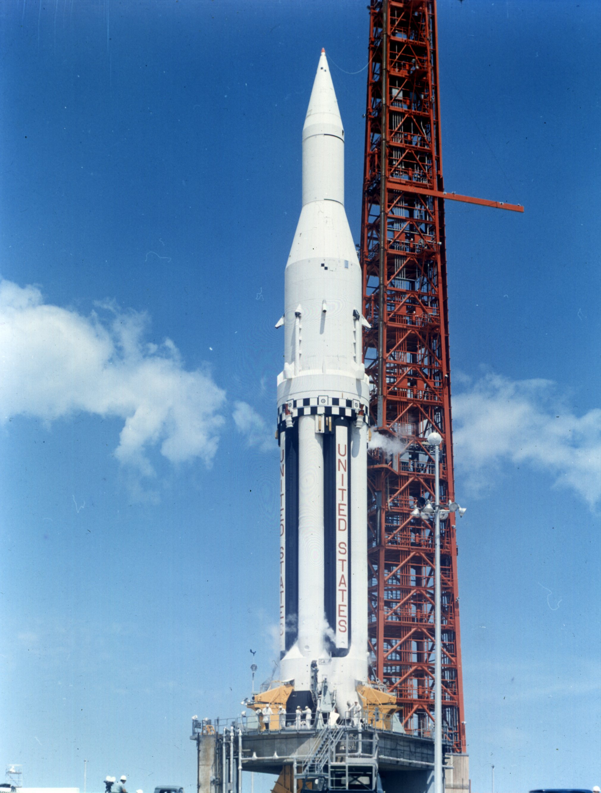
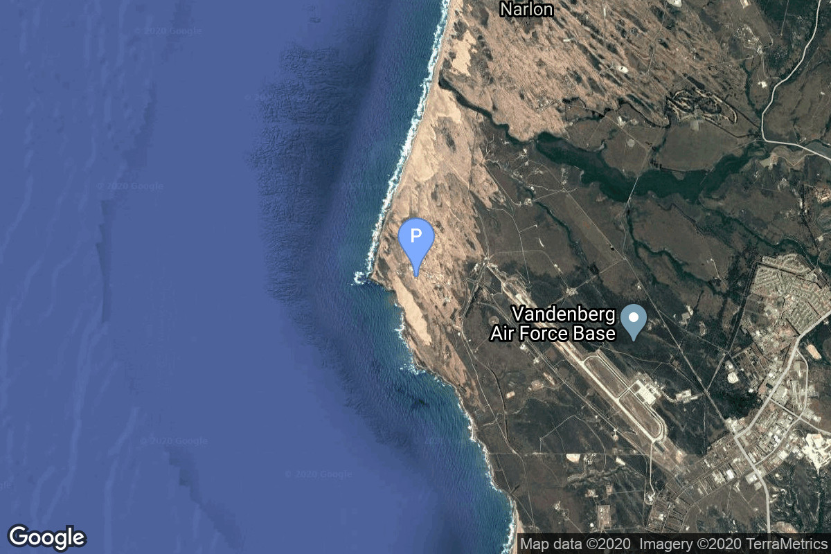
{ "count": 7494, "next": "https://ll.thespacedevs.com/2.0.0/launch/?format=api&limit=10&offset=7170&ordering=-net", "previous": "https://ll.thespacedevs.com/2.0.0/launch/?format=api&limit=10&offset=7150&ordering=-net", "results": [ { "id": "be153fff-3f17-427d-812f-dae0ddf7c488", "url": "https://ll.thespacedevs.com/2.0.0/launch/be153fff-3f17-427d-812f-dae0ddf7c488/?format=api", "launch_library_id": null, "slug": "saturn-i-saturn-sa-5", "name": "Saturn I | Saturn SA-5", "status": { "id": 3, "name": "Success" }, "net": "1964-01-29T16:25:01Z", "window_end": "1964-01-29T16:25:01Z", "window_start": "1964-01-29T16:25:01Z", "inhold": false, "tbdtime": false, "tbddate": false, "probability": null, "holdreason": "", "failreason": "", "hashtag": null, "launch_service_provider": { "id": 44, "url": "https://ll.thespacedevs.com/2.0.0/agencies/44/?format=api", "name": "National Aeronautics and Space Administration", "type": "Government" }, "rocket": { "id": 3252, "configuration": { "id": 355, "launch_library_id": null, "url": "https://ll.thespacedevs.com/2.0.0/config/launcher/355/?format=api", "name": "Saturn I", "family": "Saturn", "full_name": "Saturn I", "variant": "I" } }, "mission": { "id": 1674, "launch_library_id": null, "name": "Saturn SA-5", "description": "First orbital test flight of the Saturn-IV upper stage of the Saturn-1 (Block-2) launch vehicle. The payload consisted of a ballasted and instrumented nosecone attached to the Saturn-IV stage.", "launch_designator": null, "type": "Test Flight", "orbit": { "id": 8, "name": "Low Earth Orbit", "abbrev": "LEO" } }, "pad": { "id": 38, "url": "https://ll.thespacedevs.com/2.0.0/pad/38/?format=api", "agency_id": null, "name": "Space Launch Complex 37B", "info_url": null, "wiki_url": "https://en.wikipedia.org/wiki/Cape_Canaveral_Air_Force_Station_Space_Launch_Complex_37", "map_url": "https://www.google.com/maps?q=28.5317,-80.56495", "latitude": "28.5317", "longitude": "-80.56495", "location": { "id": 12, "url": "https://ll.thespacedevs.com/2.0.0/location/12/?format=api", "name": "Cape Canaveral SFS, FL, USA", "country_code": "USA", "map_image": "https://thespacedevs-prod.nyc3.digitaloceanspaces.com/media/map_images/location_12_20200803142519.jpg", "total_launch_count": 1022, "total_landing_count": 64 }, "map_image": "https://thespacedevs-prod.nyc3.digitaloceanspaces.com/media/map_images/pad_38_20200803143515.jpg", "total_launch_count": 40 }, "webcast_live": false, "image": "https://thespacedevs-prod.nyc3.digitaloceanspaces.com/media/images/saturn_1_on_lc-_image_20240411095856.jpeg", "infographic": null, "program": [ { "id": 4, "url": "https://ll.thespacedevs.com/2.0.0/program/4/?format=api", "name": "Apollo", "description": "The Apollo program was the third United States human spaceflight program carried out by the National Aeronautics and Space Administration (NASA), which succeeded in landing the first humans on the Moon from 1969 to 1972.", "agencies": [ { "id": 44, "url": "https://ll.thespacedevs.com/2.0.0/agencies/44/?format=api", "name": "National Aeronautics and Space Administration", "type": "Government" } ], "image_url": "https://thespacedevs-prod.nyc3.digitaloceanspaces.com/media/images/apollo_program_20200820200202.png", "start_date": "1966-11-16T00:00:00Z", "end_date": "1972-12-19T19:24:59Z", "info_url": "https://www.nasa.gov/mission_pages/apollo/index.html", "wiki_url": "https://en.wikipedia.org/wiki/Apollo_program" } ] }, { "id": "f023ec2a-a408-44cc-9360-4f8744e06e99", "url": "https://ll.thespacedevs.com/2.0.0/launch/f023ec2a-a408-44cc-9360-4f8744e06e99/?format=api", "launch_library_id": null, "slug": "thor-slv-2-agena-b-echo-2", "name": "Thor SLV-2 Agena B | Echo 2", "status": { "id": 3, "name": "Success" }, "net": "1964-01-25T13:59:04Z", "window_end": "1964-01-25T13:59:04Z", "window_start": "1964-01-25T13:59:04Z", "inhold": false, "tbdtime": false, "tbddate": false, "probability": null, "holdreason": "", "failreason": null, "hashtag": null, "launch_service_provider": { "id": 161, "url": "https://ll.thespacedevs.com/2.0.0/agencies/161/?format=api", "name": "United States Air Force", "type": "Government" }, "rocket": { "id": 3251, "configuration": { "id": 414, "launch_library_id": null, "url": "https://ll.thespacedevs.com/2.0.0/config/launcher/414/?format=api", "name": "Thor SLV-2 Agena B", "family": "Thor", "full_name": "Thor SLV-2 Agena B", "variant": "SLV-2 Agena B" } }, "mission": { "id": 1673, "launch_library_id": null, "name": "Echo 2", "description": "The Echo 2 spacecraft was a 41-m balloon of aluminum foil-mylar laminate. Echo 2 was designed as a rigidized passive communications spacecraft for testing propagation, tracking, and communication techniques.", "launch_designator": null, "type": "Communications", "orbit": { "id": 8, "name": "Low Earth Orbit", "abbrev": "LEO" } }, "pad": { "id": 98, "url": "https://ll.thespacedevs.com/2.0.0/pad/98/?format=api", "agency_id": 161, "name": "Space Launch Complex 2E", "info_url": null, "wiki_url": "https://en.wikipedia.org/wiki/Vandenberg_Space_Launch_Complex_2", "map_url": "https://www.google.com/maps?q=34.7516,-120.6192", "latitude": "34.7516", "longitude": "-120.6192", "location": { "id": 11, "url": "https://ll.thespacedevs.com/2.0.0/location/11/?format=api", "name": "Vandenberg SFB, CA, USA", "country_code": "USA", "map_image": "https://thespacedevs-prod.nyc3.digitaloceanspaces.com/media/map_images/location_11_20200803142416.jpg", "total_launch_count": 806, "total_landing_count": 26 }, "map_image": "https://thespacedevs-prod.nyc3.digitaloceanspaces.com/media/map_images/pad_98_20200803143228.jpg", "total_launch_count": 47 }, "webcast_live": false, "image": null, "infographic": null, "program": [] }, { "id": "a6489b52-40b8-49cb-8fdb-9fd7ca6ae2cd", "url": "https://ll.thespacedevs.com/2.0.0/launch/a6489b52-40b8-49cb-8fdb-9fd7ca6ae2cd/?format=api", "launch_library_id": null, "slug": "thor-delta-b-relay-2", "name": "Thor Delta B | Relay 2", "status": { "id": 3, "name": "Success" }, "net": "1964-01-21T21:14:59Z", "window_end": "1964-01-21T21:14:59Z", "window_start": "1964-01-21T21:14:59Z", "inhold": false, "tbdtime": false, "tbddate": false, "probability": null, "holdreason": "", "failreason": null, "hashtag": null, "launch_service_provider": { "id": 161, "url": "https://ll.thespacedevs.com/2.0.0/agencies/161/?format=api", "name": "United States Air Force", "type": "Government" }, "rocket": { "id": 3250, "configuration": { "id": 400, "launch_library_id": null, "url": "https://ll.thespacedevs.com/2.0.0/config/launcher/400/?format=api", "name": "Thor Delta B", "family": "Thor", "full_name": "Thor Delta B", "variant": "Delta B" } }, "mission": { "id": 1672, "launch_library_id": null, "name": "Relay 2", "description": "Relay 2, although principally a communications satellite, carried particle experiments designed to map the trapped radiation belt.", "launch_designator": null, "type": "Communications", "orbit": { "id": 0, "name": "Elliptical Orbit", "abbrev": "Elliptical" } }, "pad": { "id": 1, "url": "https://ll.thespacedevs.com/2.0.0/pad/1/?format=api", "agency_id": null, "name": "Space Launch Complex 17B", "info_url": null, "wiki_url": "https://en.wikipedia.org/wiki/Cape_Canaveral_Space_Launch_Complex_17", "map_url": "https://www.google.com/maps?q=28.4458,-80.5657", "latitude": "28.4458", "longitude": "-80.5657", "location": { "id": 12, "url": "https://ll.thespacedevs.com/2.0.0/location/12/?format=api", "name": "Cape Canaveral SFS, FL, USA", "country_code": "USA", "map_image": "https://thespacedevs-prod.nyc3.digitaloceanspaces.com/media/map_images/location_12_20200803142519.jpg", "total_launch_count": 1022, "total_landing_count": 64 }, "map_image": "https://thespacedevs-prod.nyc3.digitaloceanspaces.com/media/map_images/pad_1_20200803143208.jpg", "total_launch_count": 132 }, "webcast_live": false, "image": null, "infographic": null, "program": [] }, { "id": "894e6fb9-28ef-4cb2-9b73-d0d88c668496", "url": "https://ll.thespacedevs.com/2.0.0/launch/894e6fb9-28ef-4cb2-9b73-d0d88c668496/?format=api", "launch_library_id": null, "slug": "thor-slv-2-agena-d-dsap-1-f6-f7", "name": "Thor SLV-2 Agena D | DSAP-1 F6 & F7", "status": { "id": 3, "name": "Success" }, "net": "1964-01-19T10:59:54Z", "window_end": "1964-01-19T10:59:54Z", "window_start": "1964-01-19T10:59:54Z", "inhold": false, "tbdtime": false, "tbddate": false, "probability": null, "holdreason": "", "failreason": null, "hashtag": null, "launch_service_provider": { "id": 161, "url": "https://ll.thespacedevs.com/2.0.0/agencies/161/?format=api", "name": "United States Air Force", "type": "Government" }, "rocket": { "id": 3249, "configuration": { "id": 415, "launch_library_id": null, "url": "https://ll.thespacedevs.com/2.0.0/config/launcher/415/?format=api", "name": "Thor SLV-2 Agena D", "family": "Thor", "full_name": "Thor SLV-2 Agena D", "variant": "SLV-2 Agena D" } }, "mission": { "id": 1671, "launch_library_id": null, "name": "DSAP-1 F6 & F7", "description": "The DSAP-1 (Defense Satellite Application Program Block 1) satellites series, also known as P-35, was the first series of military meteorologal satellites of the USA.", "launch_designator": null, "type": "Government/Top Secret", "orbit": { "id": 17, "name": "Sun-Synchronous Orbit", "abbrev": "SSO" } }, "pad": { "id": 39, "url": "https://ll.thespacedevs.com/2.0.0/pad/39/?format=api", "agency_id": null, "name": "Space Launch Complex 2W", "info_url": null, "wiki_url": "https://en.wikipedia.org/wiki/Vandenberg_Space_Launch_Complex_2", "map_url": "https://www.google.com/maps?q=34.7556,-120.6224", "latitude": "34.7556", "longitude": "-120.6224", "location": { "id": 11, "url": "https://ll.thespacedevs.com/2.0.0/location/11/?format=api", "name": "Vandenberg SFB, CA, USA", "country_code": "USA", "map_image": "https://thespacedevs-prod.nyc3.digitaloceanspaces.com/media/map_images/location_11_20200803142416.jpg", "total_launch_count": 806, "total_landing_count": 26 }, "map_image": "https://thespacedevs-prod.nyc3.digitaloceanspaces.com/media/map_images/pad_39_20200803143542.jpg", "total_launch_count": 98 }, "webcast_live": false, "image": null, "infographic": null, "program": [] }, { "id": "666c94ab-0e63-4004-bf4e-41795d38ea7a", "url": "https://ll.thespacedevs.com/2.0.0/launch/666c94ab-0e63-4004-bf4e-41795d38ea7a/?format=api", "launch_library_id": null, "slug": "thor-slv-2a-agena-d-poppy-5a-5b-5c", "name": "Thor SLV-2A Agena D | Poppy 5A, 5B & 5C", "status": { "id": 3, "name": "Success" }, "net": "1964-01-11T20:07:00Z", "window_end": "1964-01-11T20:07:00Z", "window_start": "1964-01-11T20:07:00Z", "inhold": false, "tbdtime": false, "tbddate": false, "probability": null, "holdreason": "", "failreason": null, "hashtag": null, "launch_service_provider": { "id": 161, "url": "https://ll.thespacedevs.com/2.0.0/agencies/161/?format=api", "name": "United States Air Force", "type": "Government" }, "rocket": { "id": 3248, "configuration": { "id": 417, "launch_library_id": null, "url": "https://ll.thespacedevs.com/2.0.0/config/launcher/417/?format=api", "name": "Thor SLV-2A Agena D", "family": "Thor", "full_name": "Thor SLV-2A Agena D", "variant": "SLV-2A Agena D" } }, "mission": { "id": 1670, "launch_library_id": null, "name": "Poppy 5A, 5B & 5C", "description": "Poppy was the follow-on ELINT system, which succeeded the Grab ELINT satellite system.", "launch_designator": null, "type": "Government/Top Secret", "orbit": { "id": 8, "name": "Low Earth Orbit", "abbrev": "LEO" } }, "pad": { "id": 96, "url": "https://ll.thespacedevs.com/2.0.0/pad/96/?format=api", "agency_id": 161, "name": "Space Launch Complex 1E", "info_url": null, "wiki_url": "https://en.wikipedia.org/wiki/Vandenberg_Space_Launch_Complex_1", "map_url": "https://www.google.com/maps?q=34.756,-120.6263", "latitude": "34.756", "longitude": "-120.6263", "location": { "id": 11, "url": "https://ll.thespacedevs.com/2.0.0/location/11/?format=api", "name": "Vandenberg SFB, CA, USA", "country_code": "USA", "map_image": "https://thespacedevs-prod.nyc3.digitaloceanspaces.com/media/map_images/location_11_20200803142416.jpg", "total_launch_count": 806, "total_landing_count": 26 }, "map_image": "https://thespacedevs-prod.nyc3.digitaloceanspaces.com/media/map_images/pad_96_20200803143221.jpg", "total_launch_count": 45 }, "webcast_live": false, "image": null, "infographic": null, "program": [] }, { "id": "7bfdf2f7-619f-46cd-867d-e147e30670b0", "url": "https://ll.thespacedevs.com/2.0.0/launch/7bfdf2f7-619f-46cd-867d-e147e30670b0/?format=api", "launch_library_id": null, "slug": "thor-slv-2a-agena-d-kh-4-26", "name": "Thor SLV-2A Agena D | KH-4 26", "status": { "id": 3, "name": "Success" }, "net": "1963-12-21T21:45:42Z", "window_end": "1963-12-21T21:45:42Z", "window_start": "1963-12-21T21:45:42Z", "inhold": false, "tbdtime": false, "tbddate": false, "probability": null, "holdreason": "", "failreason": null, "hashtag": null, "launch_service_provider": { "id": 161, "url": "https://ll.thespacedevs.com/2.0.0/agencies/161/?format=api", "name": "United States Air Force", "type": "Government" }, "rocket": { "id": 3247, "configuration": { "id": 417, "launch_library_id": null, "url": "https://ll.thespacedevs.com/2.0.0/config/launcher/417/?format=api", "name": "Thor SLV-2A Agena D", "family": "Thor", "full_name": "Thor SLV-2A Agena D", "variant": "SLV-2A Agena D" } }, "mission": { "id": 1669, "launch_library_id": null, "name": "KH-4 26", "description": "The KH-4 (Keyhole-4) was fourth version in the Corona-program to build an optical reconnaissance satellite. KH-4 24 also carried the RM 5 radiometer payload for background measurements for the MIDAS program.", "launch_designator": null, "type": "Government/Top Secret", "orbit": { "id": 8, "name": "Low Earth Orbit", "abbrev": "LEO" } }, "pad": { "id": 39, "url": "https://ll.thespacedevs.com/2.0.0/pad/39/?format=api", "agency_id": null, "name": "Space Launch Complex 2W", "info_url": null, "wiki_url": "https://en.wikipedia.org/wiki/Vandenberg_Space_Launch_Complex_2", "map_url": "https://www.google.com/maps?q=34.7556,-120.6224", "latitude": "34.7556", "longitude": "-120.6224", "location": { "id": 11, "url": "https://ll.thespacedevs.com/2.0.0/location/11/?format=api", "name": "Vandenberg SFB, CA, USA", "country_code": "USA", "map_image": "https://thespacedevs-prod.nyc3.digitaloceanspaces.com/media/map_images/location_11_20200803142416.jpg", "total_launch_count": 806, "total_landing_count": 26 }, "map_image": "https://thespacedevs-prod.nyc3.digitaloceanspaces.com/media/map_images/pad_39_20200803143542.jpg", "total_launch_count": 98 }, "webcast_live": false, "image": null, "infographic": null, "program": [] }, { "id": "a715867d-a88f-4986-8019-8c61334a1728", "url": "https://ll.thespacedevs.com/2.0.0/launch/a715867d-a88f-4986-8019-8c61334a1728/?format=api", "launch_library_id": null, "slug": "thor-delta-b-tiros-8", "name": "Thor Delta B | Tiros 8", "status": { "id": 3, "name": "Success" }, "net": "1963-12-21T09:30:00Z", "window_end": "1963-12-21T09:30:00Z", "window_start": "1963-12-21T09:30:00Z", "inhold": false, "tbdtime": false, "tbddate": false, "probability": null, "holdreason": "", "failreason": null, "hashtag": null, "launch_service_provider": { "id": 161, "url": "https://ll.thespacedevs.com/2.0.0/agencies/161/?format=api", "name": "United States Air Force", "type": "Government" }, "rocket": { "id": 3246, "configuration": { "id": 400, "launch_library_id": null, "url": "https://ll.thespacedevs.com/2.0.0/config/launcher/400/?format=api", "name": "Thor Delta B", "family": "Thor", "full_name": "Thor Delta B", "variant": "Delta B" } }, "mission": { "id": 1668, "launch_library_id": null, "name": "Tiros 8", "description": "NASA's TIROS (Television & Infra-Red Observation Satellite) program was the first experimental weathersatellite program.", "launch_designator": null, "type": "Earth Science", "orbit": { "id": 17, "name": "Sun-Synchronous Orbit", "abbrev": "SSO" } }, "pad": { "id": 1, "url": "https://ll.thespacedevs.com/2.0.0/pad/1/?format=api", "agency_id": null, "name": "Space Launch Complex 17B", "info_url": null, "wiki_url": "https://en.wikipedia.org/wiki/Cape_Canaveral_Space_Launch_Complex_17", "map_url": "https://www.google.com/maps?q=28.4458,-80.5657", "latitude": "28.4458", "longitude": "-80.5657", "location": { "id": 12, "url": "https://ll.thespacedevs.com/2.0.0/location/12/?format=api", "name": "Cape Canaveral SFS, FL, USA", "country_code": "USA", "map_image": "https://thespacedevs-prod.nyc3.digitaloceanspaces.com/media/map_images/location_12_20200803142519.jpg", "total_launch_count": 1022, "total_landing_count": 64 }, "map_image": "https://thespacedevs-prod.nyc3.digitaloceanspaces.com/media/map_images/pad_1_20200803143208.jpg", "total_launch_count": 132 }, "webcast_live": false, "image": null, "infographic": null, "program": [] }, { "id": "4187d467-ea7b-4db8-9a84-5d0123f5c2e7", "url": "https://ll.thespacedevs.com/2.0.0/launch/4187d467-ea7b-4db8-9a84-5d0123f5c2e7/?format=api", "launch_library_id": null, "slug": "scout-x-4-explorer-19", "name": "Scout X-4 | Explorer 19", "status": { "id": 3, "name": "Success" }, "net": "1963-12-19T18:49:25Z", "window_end": "1963-12-19T18:49:25Z", "window_start": "1963-12-19T18:49:25Z", "inhold": false, "tbdtime": false, "tbddate": false, "probability": null, "holdreason": "", "failreason": null, "hashtag": null, "launch_service_provider": { "id": 44, "url": "https://ll.thespacedevs.com/2.0.0/agencies/44/?format=api", "name": "National Aeronautics and Space Administration", "type": "Government" }, "rocket": { "id": 3245, "configuration": { "id": 370, "launch_library_id": null, "url": "https://ll.thespacedevs.com/2.0.0/config/launcher/370/?format=api", "name": "Scout X-4", "family": "Scout", "full_name": "Scout X-4", "variant": "4" } }, "mission": { "id": 1667, "launch_library_id": null, "name": "Explorer 19", "description": "Explorer 19 was the second in a series of 3.66-m inflatable spheres placed into orbit to determine atmospheric densities.", "launch_designator": null, "type": "Earth Science", "orbit": { "id": 8, "name": "Low Earth Orbit", "abbrev": "LEO" } }, "pad": { "id": 154, "url": "https://ll.thespacedevs.com/2.0.0/pad/154/?format=api", "agency_id": null, "name": "Space Launch Complex 5", "info_url": "http://www.astronautix.com/v/vandenbergslc5.html", "wiki_url": "https://en.wikipedia.org/wiki/Vandenberg_Air_Force_Base_Space_Launch_Complex_5", "map_url": "https://www.google.com/maps?q=34.6080,-120.6247", "latitude": "34.608", "longitude": "-120.6247", "location": { "id": 11, "url": "https://ll.thespacedevs.com/2.0.0/location/11/?format=api", "name": "Vandenberg SFB, CA, USA", "country_code": "USA", "map_image": "https://thespacedevs-prod.nyc3.digitaloceanspaces.com/media/map_images/location_11_20200803142416.jpg", "total_launch_count": 806, "total_landing_count": 26 }, "map_image": "https://thespacedevs-prod.nyc3.digitaloceanspaces.com/media/map_images/pad_154_20200803143408.jpg", "total_launch_count": 69 }, "webcast_live": false, "image": null, "infographic": null, "program": [] }, { "id": "119fe373-2027-45f9-b257-3406aa9c0a02", "url": "https://ll.thespacedevs.com/2.0.0/launch/119fe373-2027-45f9-b257-3406aa9c0a02/?format=api", "launch_library_id": null, "slug": "vostok-8a92-zenit-2-15", "name": "Vostok 8A92 | Zenit-2 15", "status": { "id": 3, "name": "Success" }, "net": "1963-12-19T09:28:58Z", "window_end": "1963-12-19T09:28:58Z", "window_start": "1963-12-19T09:28:58Z", "inhold": false, "tbdtime": false, "tbddate": false, "probability": null, "holdreason": "", "failreason": null, "hashtag": null, "launch_service_provider": { "id": 66, "url": "https://ll.thespacedevs.com/2.0.0/agencies/66/?format=api", "name": "Soviet Space Program", "type": "Government" }, "rocket": { "id": 3244, "configuration": { "id": 451, "launch_library_id": null, "url": "https://ll.thespacedevs.com/2.0.0/config/launcher/451/?format=api", "name": "Vostok 8A92", "family": "Vostok", "full_name": "Vostok 8A92", "variant": "8A92" } }, "mission": { "id": 1666, "launch_library_id": null, "name": "Zenit-2 15", "description": "Zenit-2 film-return and ELINT reconnaissance satellite.", "launch_designator": null, "type": "Government/Top Secret", "orbit": { "id": 8, "name": "Low Earth Orbit", "abbrev": "LEO" } }, "pad": { "id": 32, "url": "https://ll.thespacedevs.com/2.0.0/pad/32/?format=api", "agency_id": null, "name": "1/5", "info_url": null, "wiki_url": "", "map_url": "https://www.google.com/maps?q=45.92,63.342", "latitude": "45.92", "longitude": "63.342", "location": { "id": 15, "url": "https://ll.thespacedevs.com/2.0.0/location/15/?format=api", "name": "Baikonur Cosmodrome, Republic of Kazakhstan", "country_code": "KAZ", "map_image": "https://thespacedevs-prod.nyc3.digitaloceanspaces.com/media/map_images/location_15_20200803142517.jpg", "total_launch_count": 1555, "total_landing_count": 0 }, "map_image": "https://thespacedevs-prod.nyc3.digitaloceanspaces.com/media/map_images/pad_32_20200803143513.jpg", "total_launch_count": 487 }, "webcast_live": false, "image": null, "infographic": null, "program": [] }, { "id": "abe6ddea-f970-4323-8400-8eb33f16cf5f", "url": "https://ll.thespacedevs.com/2.0.0/launch/abe6ddea-f970-4323-8400-8eb33f16cf5f/?format=api", "launch_library_id": null, "slug": "atlas-agena-d-kh-7-4", "name": "Atlas Agena D | KH-7 4", "status": { "id": 3, "name": "Success" }, "net": "1963-12-18T21:45:30Z", "window_end": "1963-12-18T21:45:30Z", "window_start": "1963-12-18T21:45:30Z", "inhold": false, "tbdtime": false, "tbddate": false, "probability": null, "holdreason": "", "failreason": null, "hashtag": null, "launch_service_provider": { "id": 161, "url": "https://ll.thespacedevs.com/2.0.0/agencies/161/?format=api", "name": "United States Air Force", "type": "Government" }, "rocket": { "id": 3243, "configuration": { "id": 232, "launch_library_id": null, "url": "https://ll.thespacedevs.com/2.0.0/config/launcher/232/?format=api", "name": "Atlas Agena D", "family": "Atlas", "full_name": "Atlas LV-3 Agena D", "variant": "Agena D" } }, "mission": { "id": 1665, "launch_library_id": null, "name": "KH-7 4", "description": "The Program 206 satellite, carrying the KH-7 (Keyhole 7) camera system (codenamed Gambit-1), was the first successful high resolution space reconnaissance program. It was managed by NRO's Program A, the USAF-led segment of the National Reconnaissance Program managed from Los Angeles AFB in El Segundo, California.", "launch_designator": null, "type": "Government/Top Secret", "orbit": { "id": 17, "name": "Sun-Synchronous Orbit", "abbrev": "SSO" } }, "pad": { "id": 156, "url": "https://ll.thespacedevs.com/2.0.0/pad/156/?format=api", "agency_id": null, "name": "Space Launch Complex 4W", "info_url": "http://www.astronautix.com/v/vandenbergslc4w.html", "wiki_url": "https://en.wikipedia.org/wiki/Vandenberg_Air_Force_Base_Space_Launch_Complex_4#SLC-4W", "map_url": "https://www.google.com/maps?q=34.63312,-120.61584", "latitude": "34.63312", "longitude": "-120.61584", "location": { "id": 11, "url": "https://ll.thespacedevs.com/2.0.0/location/11/?format=api", "name": "Vandenberg SFB, CA, USA", "country_code": "USA", "map_image": "https://thespacedevs-prod.nyc3.digitaloceanspaces.com/media/map_images/location_11_20200803142416.jpg", "total_launch_count": 806, "total_landing_count": 26 }, "map_image": "https://thespacedevs-prod.nyc3.digitaloceanspaces.com/media/map_images/pad_156_20200803143351.jpg", "total_launch_count": 93 }, "webcast_live": false, "image": null, "infographic": null, "program": [] } ] }