Launch List
API endpoint that returns all Launch objects or a single launch.
EXAMPLE - /launch/
GET: Return a list of all Launch objects.
FILTERS: Fields - 'name', 'id(s)', 'lsp_id', 'lsp_name', 'serial_number', 'launcher_config__id', 'rocket__spacecraftflight__spacecraft__name'
MODE: 'normal', 'list', 'detailed' EXAMPLE: ?mode=list
SEARCH: Searches through the launch name, rocket name, launch agency, mission name & spacecraft name. EXAMPLE - ?search=SpaceX
GET /2.0.0/launch/?format=api&offset=7070&ordering=id
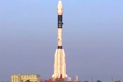
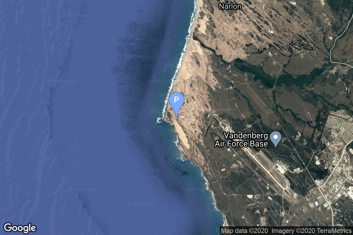
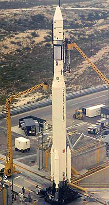
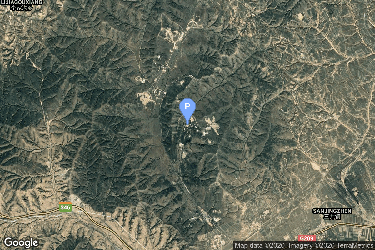
{ "count": 7943, "next": "https://ll.thespacedevs.com/2.0.0/launch/?format=api&limit=10&offset=7080&ordering=id", "previous": "https://ll.thespacedevs.com/2.0.0/launch/?format=api&limit=10&offset=7060&ordering=id", "results": [ { "id": "e2bc0c5a-7370-4f10-90de-bcaf14e991ff", "url": "https://ll.thespacedevs.com/2.0.0/launch/e2bc0c5a-7370-4f10-90de-bcaf14e991ff/?format=api", "launch_library_id": 1401, "slug": "gslv-gsat-5p", "name": "GSLV | GSAT-5P", "status": { "id": 4, "name": "Failure" }, "net": "2010-12-25T10:34:00Z", "window_end": "2010-12-25T10:34:00Z", "window_start": "2010-12-25T10:34:00Z", "inhold": false, "tbdtime": false, "tbddate": false, "probability": null, "holdreason": "", "failreason": "Destroyed by range safety officer after loss of control over liquid-fueled boosters.", "hashtag": null, "launch_service_provider": { "id": 31, "url": "https://ll.thespacedevs.com/2.0.0/agencies/31/?format=api", "name": "Indian Space Research Organization", "type": "Government" }, "rocket": { "id": 1504, "configuration": { "id": 5, "launch_library_id": 17, "url": "https://ll.thespacedevs.com/2.0.0/config/launcher/5/?format=api", "name": "GSLV", "family": "GSLV", "full_name": "GSLV", "variant": "" } }, "mission": null, "pad": { "id": 82, "url": "https://ll.thespacedevs.com/2.0.0/pad/82/?format=api", "agency_id": 31, "name": "Satish Dhawan Space Centre Second Launch Pad", "info_url": null, "wiki_url": "https://en.wikipedia.org/wiki/Satish_Dhawan_Space_Centre_Second_Launch_Pad", "map_url": "https://www.google.com/maps?q=13.7199,80.2304", "latitude": "13.7199", "longitude": "80.2304", "location": { "id": 14, "url": "https://ll.thespacedevs.com/2.0.0/location/14/?format=api", "name": "Satish Dhawan Space Centre, India", "country_code": "IND", "map_image": "https://thespacedevs-prod.nyc3.digitaloceanspaces.com/media/map_images/location_14_20200803142403.jpg", "total_launch_count": 104, "total_landing_count": 0 }, "map_image": "https://thespacedevs-prod.nyc3.digitaloceanspaces.com/media/map_images/pad_82_20200803143602.jpg", "total_launch_count": 32 }, "webcast_live": false, "image": "https://thespacedevs-prod.nyc3.digitaloceanspaces.com/media/images/gslv_image_20190604000621.jpg", "infographic": null, "program": [] }, { "id": "e2c67708-93b7-44ac-a26e-17f3c6ae1964", "url": "https://ll.thespacedevs.com/2.0.0/launch/e2c67708-93b7-44ac-a26e-17f3c6ae1964/?format=api", "launch_library_id": null, "slug": "voskhod-zenit-2-65", "name": "Voskhod | Zenit-2 65", "status": { "id": 3, "name": "Success" }, "net": "1968-09-14T06:50:00Z", "window_end": "1968-09-14T06:50:00Z", "window_start": "1968-09-14T06:50:00Z", "inhold": false, "tbdtime": false, "tbddate": false, "probability": null, "holdreason": "", "failreason": null, "hashtag": null, "launch_service_provider": { "id": 66, "url": "https://ll.thespacedevs.com/2.0.0/agencies/66/?format=api", "name": "Soviet Space Program", "type": "Government" }, "rocket": { "id": 3820, "configuration": { "id": 104, "launch_library_id": 138, "url": "https://ll.thespacedevs.com/2.0.0/config/launcher/104/?format=api", "name": "Voskhod", "family": "R-7", "full_name": "Voskhod", "variant": "Voskhod" } }, "mission": { "id": 2238, "launch_library_id": null, "name": "Zenit-2 65", "description": "Zenit-2 film-return and ELINT reconnaissance satellite.", "launch_designator": null, "type": "Government/Top Secret", "orbit": { "id": 8, "name": "Low Earth Orbit", "abbrev": "LEO" } }, "pad": { "id": 20, "url": "https://ll.thespacedevs.com/2.0.0/pad/20/?format=api", "agency_id": null, "name": "31/6", "info_url": null, "wiki_url": "https://en.wikipedia.org/wiki/Baikonur_Cosmodrome_Site_31", "map_url": "https://www.google.com/maps?q=45.996034,63.564003", "latitude": "45.996034", "longitude": "63.564003", "location": { "id": 15, "url": "https://ll.thespacedevs.com/2.0.0/location/15/?format=api", "name": "Baikonur Cosmodrome, Republic of Kazakhstan", "country_code": "KAZ", "map_image": "https://thespacedevs-prod.nyc3.digitaloceanspaces.com/media/map_images/location_15_20200803142517.jpg", "total_launch_count": 1564, "total_landing_count": 0 }, "map_image": "https://thespacedevs-prod.nyc3.digitaloceanspaces.com/media/map_images/pad_20_20200803143516.jpg", "total_launch_count": 429 }, "webcast_live": false, "image": "https://thespacedevs-prod.nyc3.digitaloceanspaces.com/media/images/voskhod_during__image_20251102062248.jpg", "infographic": null, "program": [] }, { "id": "e2cf0f59-ab1f-445b-a34f-bead921eb8d5", "url": "https://ll.thespacedevs.com/2.0.0/launch/e2cf0f59-ab1f-445b-a34f-bead921eb8d5/?format=api", "launch_library_id": null, "slug": "thorad-slv-2g-agena-d-kh-4a-35", "name": "Thorad SLV-2G Agena D | KH-4A 35", "status": { "id": 3, "name": "Success" }, "net": "1966-08-09T20:46:03Z", "window_end": "1966-08-09T20:46:03Z", "window_start": "1966-08-09T20:46:03Z", "inhold": false, "tbdtime": false, "tbddate": false, "probability": null, "holdreason": "", "failreason": null, "hashtag": null, "launch_service_provider": { "id": 161, "url": "https://ll.thespacedevs.com/2.0.0/agencies/161/?format=api", "name": "United States Air Force", "type": "Government" }, "rocket": { "id": 3557, "configuration": { "id": 418, "launch_library_id": null, "url": "https://ll.thespacedevs.com/2.0.0/config/launcher/418/?format=api", "name": "Thorad SLV-2G Agena D", "family": "Thor", "full_name": "Thorad SLV-2G Agena D", "variant": "SLV-2G Agena D" } }, "mission": { "id": 1977, "launch_library_id": null, "name": "KH-4A 35", "description": "The KH-4A (Keyhole-4A) was the fifth optical reconnaissance satellite version in the Corona-program.", "launch_designator": null, "type": "Government/Top Secret", "orbit": { "id": 8, "name": "Low Earth Orbit", "abbrev": "LEO" } }, "pad": { "id": 95, "url": "https://ll.thespacedevs.com/2.0.0/pad/95/?format=api", "agency_id": 161, "name": "Space Launch Complex 1W", "info_url": null, "wiki_url": "https://en.wikipedia.org/wiki/Vandenberg_Space_Launch_Complex_1", "map_url": "https://www.google.com/maps?q=34.7572,-120.6303", "latitude": "34.7572", "longitude": "-120.6303", "location": { "id": 11, "url": "https://ll.thespacedevs.com/2.0.0/location/11/?format=api", "name": "Vandenberg SFB, CA, USA", "country_code": "USA", "map_image": "https://thespacedevs-prod.nyc3.digitaloceanspaces.com/media/map_images/location_11_20200803142416.jpg", "total_launch_count": 902, "total_landing_count": 35 }, "map_image": "https://thespacedevs-prod.nyc3.digitaloceanspaces.com/media/map_images/pad_95_20200803143209.jpg", "total_launch_count": 56 }, "webcast_live": false, "image": "https://thespacedevs-prod.nyc3.digitaloceanspaces.com/media/images/thorad-slv2g_ag_image_20251102061406.jpg", "infographic": null, "program": [] }, { "id": "e2d43a8e-6b36-40ac-a671-de35edca331a", "url": "https://ll.thespacedevs.com/2.0.0/launch/e2d43a8e-6b36-40ac-a671-de35edca331a/?format=api", "launch_library_id": null, "slug": "long-march-4b-gaofen-11-05", "name": "Long March 4B | Gaofen-11-05", "status": { "id": 3, "name": "Success" }, "net": "2024-07-19T03:03:00Z", "window_end": "2024-07-19T03:43:00Z", "window_start": "2024-07-19T02:54:00Z", "inhold": false, "tbdtime": false, "tbddate": false, "probability": null, "holdreason": "", "failreason": "", "hashtag": null, "launch_service_provider": { "id": 88, "url": "https://ll.thespacedevs.com/2.0.0/agencies/88/?format=api", "name": "China Aerospace Science and Technology Corporation", "type": "Government" }, "rocket": { "id": 8282, "configuration": { "id": 10, "launch_library_id": 16, "url": "https://ll.thespacedevs.com/2.0.0/config/launcher/10/?format=api", "name": "Long March 4B", "family": "Long March", "full_name": "Long March 4B", "variant": "B" } }, "mission": { "id": 6863, "launch_library_id": null, "name": "Gaofen-11-05", "description": "Gaofen is a series of civilian Earth observation satellites developed and launched for the China High-definition Earth Observation System (CHEOS), a state-sponsored programme aimed to develop a near-real time, all-weather, global surveillance network consisting of satellite, near-space (stratosphere) airships, and aerial observation platforms.", "launch_designator": null, "type": "Earth Science", "orbit": { "id": 17, "name": "Sun-Synchronous Orbit", "abbrev": "SSO" } }, "pad": { "id": 25, "url": "https://ll.thespacedevs.com/2.0.0/pad/25/?format=api", "agency_id": null, "name": "Launch Complex 9", "info_url": null, "wiki_url": null, "map_url": "https://www.google.com/maps?q=38.863128,111.589567", "latitude": "38.863128", "longitude": "111.589567", "location": { "id": 19, "url": "https://ll.thespacedevs.com/2.0.0/location/19/?format=api", "name": "Taiyuan Satellite Launch Center, People's Republic of China", "country_code": "CHN", "map_image": "https://thespacedevs-prod.nyc3.digitaloceanspaces.com/media/map_images/location_19_20200803142421.jpg", "total_launch_count": 158, "total_landing_count": 0 }, "map_image": "https://thespacedevs-prod.nyc3.digitaloceanspaces.com/media/map_images/pad_25_20200803143501.jpg", "total_launch_count": 78 }, "webcast_live": false, "image": "https://thespacedevs-prod.nyc3.digitaloceanspaces.com/media/images/cz-4b_liftoff__image_20240719064703.jpeg", "infographic": null, "program": [] }, { "id": "e2ddb33c-6861-44ff-9a96-03ca6d3b1aea", "url": "https://ll.thespacedevs.com/2.0.0/launch/e2ddb33c-6861-44ff-9a96-03ca6d3b1aea/?format=api", "launch_library_id": null, "slug": "tsiklon-2-us-p-29", "name": "Tsiklon-2 | US-P 29", "status": { "id": 3, "name": "Success" }, "net": "1988-11-18T00:12:28Z", "window_end": "1988-11-18T00:12:28Z", "window_start": "1988-11-18T00:12:28Z", "inhold": false, "tbdtime": false, "tbddate": false, "probability": null, "holdreason": "", "failreason": null, "hashtag": null, "launch_service_provider": { "id": 66, "url": "https://ll.thespacedevs.com/2.0.0/agencies/66/?format=api", "name": "Soviet Space Program", "type": "Government" }, "rocket": { "id": 6127, "configuration": { "id": 443, "launch_library_id": null, "url": "https://ll.thespacedevs.com/2.0.0/config/launcher/443/?format=api", "name": "Tsiklon-2", "family": "Tsiklon", "full_name": "Tsiklon-2", "variant": "2" } }, "mission": { "id": 4517, "launch_library_id": null, "name": "US-P 29", "description": "Ocean surveillance satellite using passive ELINT devices", "launch_designator": null, "type": "Government/Top Secret", "orbit": { "id": 8, "name": "Low Earth Orbit", "abbrev": "LEO" } }, "pad": { "id": 132, "url": "https://ll.thespacedevs.com/2.0.0/pad/132/?format=api", "agency_id": null, "name": "90", "info_url": null, "wiki_url": "https://en.wikipedia.org/wiki/Baikonur_Cosmodrome_Site_90", "map_url": "https://www.google.com/maps?q=46.081,62.929806", "latitude": "46.081", "longitude": "62.929806", "location": { "id": 15, "url": "https://ll.thespacedevs.com/2.0.0/location/15/?format=api", "name": "Baikonur Cosmodrome, Republic of Kazakhstan", "country_code": "KAZ", "map_image": "https://thespacedevs-prod.nyc3.digitaloceanspaces.com/media/map_images/location_15_20200803142517.jpg", "total_launch_count": 1564, "total_landing_count": 0 }, "map_image": "https://thespacedevs-prod.nyc3.digitaloceanspaces.com/media/map_images/pad_132_20200803143344.jpg", "total_launch_count": 74 }, "webcast_live": false, "image": "https://thespacedevs-prod.nyc3.digitaloceanspaces.com/media/images/tsyklon-2_lifto_image_20240411113159.jpg", "infographic": null, "program": [] }, { "id": "e2e124ef-fed1-4c54-852f-2c6206ae5e9b", "url": "https://ll.thespacedevs.com/2.0.0/launch/e2e124ef-fed1-4c54-852f-2c6206ae5e9b/?format=api", "launch_library_id": null, "slug": "atlas-iia-orion-1", "name": "Atlas IIA | Orion 1", "status": { "id": 3, "name": "Success" }, "net": "1994-11-29T10:21:02Z", "window_end": "1994-11-29T10:21:02Z", "window_start": "1994-11-29T10:21:02Z", "inhold": false, "tbdtime": false, "tbddate": false, "probability": null, "holdreason": "", "failreason": null, "hashtag": null, "launch_service_provider": { "id": 161, "url": "https://ll.thespacedevs.com/2.0.0/agencies/161/?format=api", "name": "United States Air Force", "type": "Government" }, "rocket": { "id": 6629, "configuration": { "id": 254, "launch_library_id": null, "url": "https://ll.thespacedevs.com/2.0.0/config/launcher/254/?format=api", "name": "Atlas IIA", "family": "Atlas", "full_name": "Atlas IIA", "variant": "IIA" } }, "mission": { "id": 5019, "launch_library_id": null, "name": "Orion 1", "description": "The Orion 1 telecommunications satellite, launched in November 1994, was the first purchase of a European satellite by a US-based company. Its 34 Ku-band transponders serve Europe, the United States to the Rocky Mountains and parts of Canada and Mexico, providing video for broadcast and business television, high-speed Internet access and multimedia services, broadband and data networking.", "launch_designator": null, "type": "Communications", "orbit": { "id": 1, "name": "Geostationary Orbit", "abbrev": "Direct-GEO" } }, "pad": { "id": 121, "url": "https://ll.thespacedevs.com/2.0.0/pad/121/?format=api", "agency_id": 161, "name": "Launch Complex 36A", "info_url": null, "wiki_url": "https://en.wikipedia.org/wiki/Cape_Canaveral_Launch_Complex_36", "map_url": "https://www.google.com/maps?q=28.4705556,-80.542194", "latitude": "28.4705556", "longitude": "-80.542194", "location": { "id": 12, "url": "https://ll.thespacedevs.com/2.0.0/location/12/?format=api", "name": "Cape Canaveral SFS, FL, USA", "country_code": "USA", "map_image": "https://thespacedevs-prod.nyc3.digitaloceanspaces.com/media/map_images/location_12_20200803142519.jpg", "total_launch_count": 1123, "total_landing_count": 76 }, "map_image": "https://thespacedevs-prod.nyc3.digitaloceanspaces.com/media/map_images/pad_121_20200803143231.jpg", "total_launch_count": 71 }, "webcast_live": false, "image": "https://thespacedevs-prod.nyc3.digitaloceanspaces.com/media/images/launch_of_an_at_image_20251123092831.jpg", "infographic": null, "program": [] }, { "id": "e2e83236-e353-4ad5-899a-f575d49bebc9", "url": "https://ll.thespacedevs.com/2.0.0/launch/e2e83236-e353-4ad5-899a-f575d49bebc9/?format=api", "launch_library_id": null, "slug": "energiya-polyus", "name": "Energiya | Polyus", "status": { "id": 4, "name": "Failure" }, "net": "1987-05-15T17:30:01Z", "window_end": "1987-05-15T17:30:01Z", "window_start": "1987-05-15T17:30:01Z", "inhold": false, "tbdtime": false, "tbddate": false, "probability": null, "holdreason": "", "failreason": "", "hashtag": null, "launch_service_provider": { "id": 66, "url": "https://ll.thespacedevs.com/2.0.0/agencies/66/?format=api", "name": "Soviet Space Program", "type": "Government" }, "rocket": { "id": 5967, "configuration": { "id": 314, "launch_library_id": null, "url": "https://ll.thespacedevs.com/2.0.0/config/launcher/314/?format=api", "name": "Energiya", "family": "Energiya", "full_name": "Energiya", "variant": "" } }, "mission": { "id": 4361, "launch_library_id": null, "name": "Polyus", "description": "Satellite used to test technologies for the Skif-D SDI program", "launch_designator": null, "type": "Government/Top Secret", "orbit": { "id": 8, "name": "Low Earth Orbit", "abbrev": "LEO" } }, "pad": { "id": 163, "url": "https://ll.thespacedevs.com/2.0.0/pad/163/?format=api", "agency_id": null, "name": "250", "info_url": null, "wiki_url": "https://en.wikipedia.org/wiki/Baikonur_Cosmodrome", "map_url": "https://www.google.com/maps?q=46.008,63.302806", "latitude": "46.008", "longitude": "63.302806", "location": { "id": 15, "url": "https://ll.thespacedevs.com/2.0.0/location/15/?format=api", "name": "Baikonur Cosmodrome, Republic of Kazakhstan", "country_code": "KAZ", "map_image": "https://thespacedevs-prod.nyc3.digitaloceanspaces.com/media/map_images/location_15_20200803142517.jpg", "total_launch_count": 1564, "total_landing_count": 0 }, "map_image": "https://thespacedevs-prod.nyc3.digitaloceanspaces.com/media/map_images/pad_163_20200803143510.jpg", "total_launch_count": 1 }, "webcast_live": false, "image": "https://thespacedevs-prod.nyc3.digitaloceanspaces.com/media/images/energia_with_po_image_20240411093709.jpg", "infographic": null, "program": [] }, { "id": "e2ea18ed-35f1-4bc0-8187-40c1b8553eb8", "url": "https://ll.thespacedevs.com/2.0.0/launch/e2ea18ed-35f1-4bc0-8187-40c1b8553eb8/?format=api", "launch_library_id": null, "slug": "kuaizhou-1a-tianxing-1", "name": "Kuaizhou 1A | Tianxing-1", "status": { "id": 3, "name": "Success" }, "net": "2022-06-22T02:08:00Z", "window_end": "2022-06-22T02:08:00Z", "window_start": "2022-06-22T02:08:00Z", "inhold": false, "tbdtime": false, "tbddate": false, "probability": null, "holdreason": "", "failreason": "", "hashtag": null, "launch_service_provider": { "id": 194, "url": "https://ll.thespacedevs.com/2.0.0/agencies/194/?format=api", "name": "ExPace", "type": "Commercial" }, "rocket": { "id": 7489, "configuration": { "id": 135, "launch_library_id": 155, "url": "https://ll.thespacedevs.com/2.0.0/config/launcher/135/?format=api", "name": "Kuaizhou 1A", "family": "Kuaizhou", "full_name": "Kuaizhou 1A", "variant": "1A" } }, "mission": { "id": 6975, "launch_library_id": null, "name": "Tianxing-1", "description": "Satellite reported as for \"spatial environment measurement\" purposes. Actual usage TBD.", "launch_designator": null, "type": "Technology", "orbit": { "id": 17, "name": "Sun-Synchronous Orbit", "abbrev": "SSO" } }, "pad": { "id": 21, "url": "https://ll.thespacedevs.com/2.0.0/pad/21/?format=api", "agency_id": null, "name": "Launch Area 95A", "info_url": null, "wiki_url": "https://en.wikipedia.org/wiki/Jiuquan_Satellite_Launch_Center", "map_url": "https://www.google.com/maps?q=40.969117,100.343333", "latitude": "40.969117", "longitude": "100.343333", "location": { "id": 17, "url": "https://ll.thespacedevs.com/2.0.0/location/17/?format=api", "name": "Jiuquan Satellite Launch Center, People's Republic of China", "country_code": "CHN", "map_image": "https://thespacedevs-prod.nyc3.digitaloceanspaces.com/media/map_images/location_17_20200803142429.jpg", "total_launch_count": 292, "total_landing_count": 2 }, "map_image": "https://thespacedevs-prod.nyc3.digitaloceanspaces.com/media/map_images/pad_21_20200803143253.jpg", "total_launch_count": 67 }, "webcast_live": false, "image": "https://thespacedevs-prod.nyc3.digitaloceanspaces.com/media/images/kuaizhou_1a_lau_image_20251206092920.jpeg", "infographic": null, "program": [] }, { "id": "e30c1459-4848-4762-835d-d2ce08114010", "url": "https://ll.thespacedevs.com/2.0.0/launch/e30c1459-4848-4762-835d-d2ce08114010/?format=api", "launch_library_id": null, "slug": "delta-ii-deep-impact-dif", "name": "Delta II | Deep Impact (DIF)", "status": { "id": 3, "name": "Success" }, "net": "2005-01-12T18:47:08Z", "window_end": "2005-01-12T18:47:08Z", "window_start": "2005-01-12T18:47:08Z", "inhold": false, "tbdtime": false, "tbddate": false, "probability": null, "holdreason": "", "failreason": "", "hashtag": null, "launch_service_provider": { "id": 161, "url": "https://ll.thespacedevs.com/2.0.0/agencies/161/?format=api", "name": "United States Air Force", "type": "Government" }, "rocket": { "id": 7212, "configuration": { "id": 140, "launch_library_id": 181, "url": "https://ll.thespacedevs.com/2.0.0/config/launcher/140/?format=api", "name": "Delta II", "family": "Delta", "full_name": "Delta II 7925-9.5", "variant": "7925-9.5" } }, "mission": { "id": 5601, "launch_library_id": null, "name": "Deep Impact (DIF)", "description": "Deep Impact was to fly by Comet 9P/Tempel-1 on 3 July 2005. An impacter it released was to hit the comet on 4 July at 10.2 km/s, producing a crater and ejecta plume that would allow the flyby spacecraft to determine the composition and structure of the comet's nucleus.", "launch_designator": null, "type": "Planetary Science", "orbit": { "id": 21, "name": "Asteroid", "abbrev": "Asteroid" } }, "pad": { "id": 1, "url": "https://ll.thespacedevs.com/2.0.0/pad/1/?format=api", "agency_id": null, "name": "Space Launch Complex 17B", "info_url": null, "wiki_url": "https://en.wikipedia.org/wiki/Cape_Canaveral_Space_Launch_Complex_17", "map_url": "https://www.google.com/maps?q=28.4458,-80.5657", "latitude": "28.4458", "longitude": "-80.5657", "location": { "id": 12, "url": "https://ll.thespacedevs.com/2.0.0/location/12/?format=api", "name": "Cape Canaveral SFS, FL, USA", "country_code": "USA", "map_image": "https://thespacedevs-prod.nyc3.digitaloceanspaces.com/media/map_images/location_12_20200803142519.jpg", "total_launch_count": 1123, "total_landing_count": 76 }, "map_image": "https://thespacedevs-prod.nyc3.digitaloceanspaces.com/media/map_images/pad_1_20200803143208.jpg", "total_launch_count": 132 }, "webcast_live": false, "image": "https://thespacedevs-prod.nyc3.digitaloceanspaces.com/media/images/delta_ii_7925-9_image_20240312090356.jpeg", "infographic": null, "program": [ { "id": 33, "url": "https://ll.thespacedevs.com/2.0.0/program/33/?format=api", "name": "Discovery Program", "description": "The Discovery Program is a series of Solar System exploration missions funded by the U.S. National Aeronautics and Space Administration (NASA) through its Planetary Missions Program Office. The cost of each mission is capped at a lower level than missions from NASA's New Frontiers or Flagship Programs. As a result, Discovery missions tend to be more focused on a specific scientific goal rather than serving a general purpose.", "agencies": [ { "id": 44, "url": "https://ll.thespacedevs.com/2.0.0/agencies/44/?format=api", "name": "National Aeronautics and Space Administration", "type": "Government" } ], "image_url": "https://thespacedevs-prod.nyc3.digitaloceanspaces.com/media/images/discovery2520p_program_20231231122246.jpeg", "start_date": "1990-01-01T00:00:00Z", "end_date": null, "info_url": "https://www.nasa.gov/planetarymissions/discovery-program/", "wiki_url": "https://en.wikipedia.org/wiki/Discovery_Program" } ] }, { "id": "e30f2995-fc11-4b3d-8683-d5361cd752cf", "url": "https://ll.thespacedevs.com/2.0.0/launch/e30f2995-fc11-4b3d-8683-d5361cd752cf/?format=api", "launch_library_id": null, "slug": "soyuz-u-zenit-2m-91", "name": "Soyuz U | Zenit-2M 91", "status": { "id": 3, "name": "Success" }, "net": "1978-10-17T15:00:00Z", "window_end": "1978-10-17T15:00:00Z", "window_start": "1978-10-17T15:00:00Z", "inhold": false, "tbdtime": false, "tbddate": false, "probability": null, "holdreason": "", "failreason": null, "hashtag": null, "launch_service_provider": { "id": 66, "url": "https://ll.thespacedevs.com/2.0.0/agencies/66/?format=api", "name": "Soviet Space Program", "type": "Government" }, "rocket": { "id": 5005, "configuration": { "id": 37, "launch_library_id": 35, "url": "https://ll.thespacedevs.com/2.0.0/config/launcher/37/?format=api", "name": "Soyuz U", "family": "Soyuz", "full_name": "Soyuz U", "variant": "" } }, "mission": { "id": 3419, "launch_library_id": null, "name": "Zenit-2M 91", "description": "The soviet Zenit-2M (Gektor, 11F690) was an improved version of the Zenit-2 area surveillance reconnaissance satellite. It was part of the Vostok-based Zenit-family.", "launch_designator": null, "type": "Government/Top Secret", "orbit": { "id": 8, "name": "Low Earth Orbit", "abbrev": "LEO" } }, "pad": { "id": 85, "url": "https://ll.thespacedevs.com/2.0.0/pad/85/?format=api", "agency_id": 163, "name": "43/4 (43R)", "info_url": null, "wiki_url": null, "map_url": "https://www.google.com/maps?q=62.92883,40.457098", "latitude": "62.92883", "longitude": "40.457098", "location": { "id": 6, "url": "https://ll.thespacedevs.com/2.0.0/location/6/?format=api", "name": "Plesetsk Cosmodrome, Russian Federation", "country_code": "RUS", "map_image": "https://thespacedevs-prod.nyc3.digitaloceanspaces.com/media/map_images/location_6_20200803142434.jpg", "total_launch_count": 1686, "total_landing_count": 0 }, "map_image": "https://thespacedevs-prod.nyc3.digitaloceanspaces.com/media/map_images/pad_85_20200803143554.jpg", "total_launch_count": 329 }, "webcast_live": false, "image": "https://thespacedevs-prod.nyc3.digitaloceanspaces.com/media/images/soyuz2520u_image_20190222031023.jpeg", "infographic": null, "program": [] } ] }