Launch List
API endpoint that returns all Launch objects or a single launch.
EXAMPLE - /launch/
GET: Return a list of all Launch objects.
FILTERS: Fields - 'name', 'id(s)', 'lsp_id', 'lsp_name', 'serial_number', 'launcher_config__id', 'rocket__spacecraftflight__spacecraft__name'
MODE: 'normal', 'list', 'detailed' EXAMPLE: ?mode=list
SEARCH: Searches through the launch name, rocket name, launch agency, mission name & spacecraft name. EXAMPLE - ?search=SpaceX
GET /2.0.0/launch/?format=api&offset=6910&ordering=id
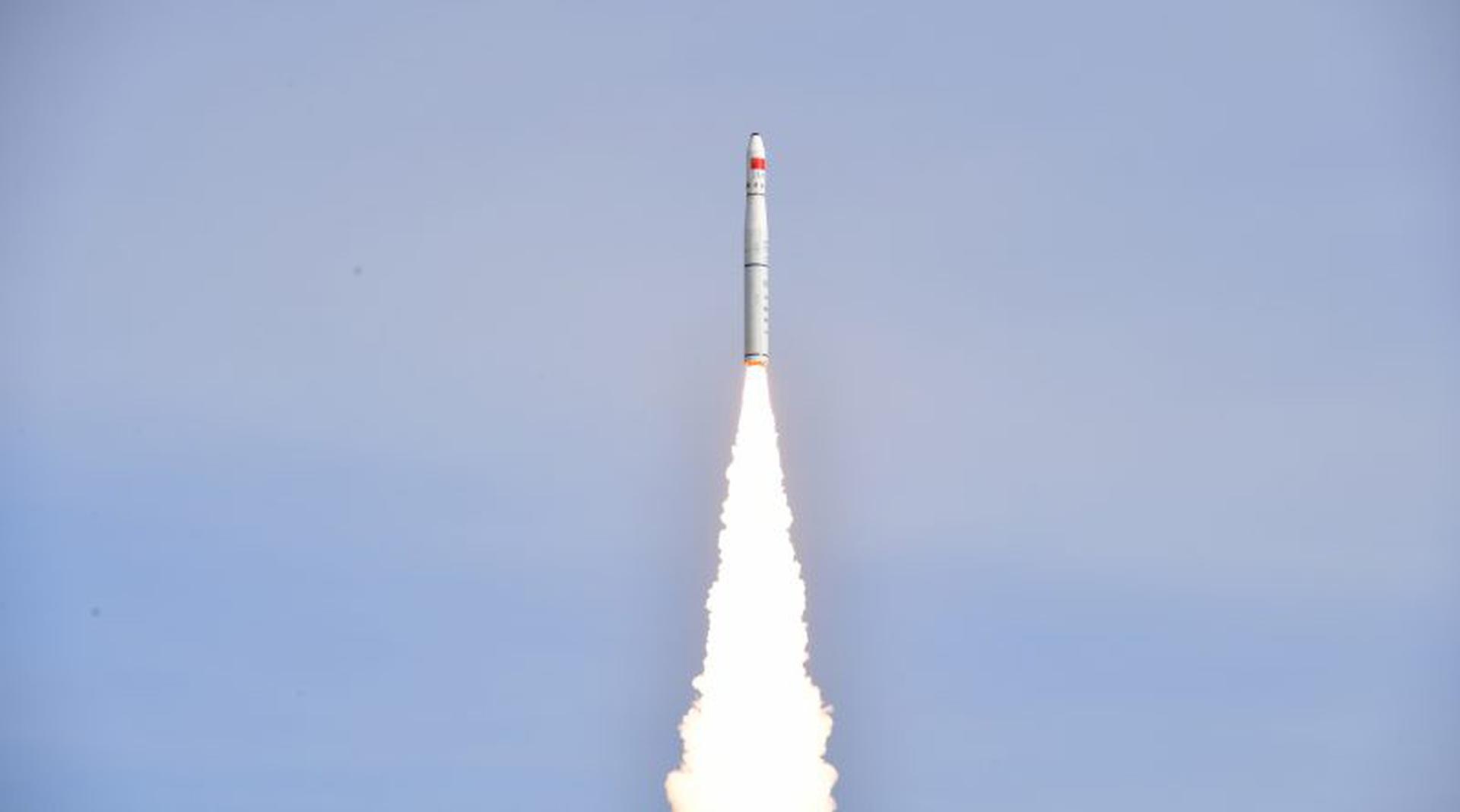
{ "count": 7503, "next": "https://ll.thespacedevs.com/2.0.0/launch/?format=api&limit=10&offset=6920&ordering=id", "previous": "https://ll.thespacedevs.com/2.0.0/launch/?format=api&limit=10&offset=6900&ordering=id", "results": [ { "id": "eb04ce84-7135-46b1-b219-55dff758c5cf", "url": "https://ll.thespacedevs.com/2.0.0/launch/eb04ce84-7135-46b1-b219-55dff758c5cf/?format=api", "launch_library_id": null, "slug": "kosmos-11k63-ds-u2-ik-3-kopernik-500", "name": "Kosmos 11K63 | DS-U2-IK 3 & Kopernik-500", "status": { "id": 3, "name": "Success" }, "net": "1973-04-19T10:19:58Z", "window_end": "1973-04-19T10:19:58Z", "window_start": "1973-04-19T10:19:58Z", "inhold": false, "tbdtime": false, "tbddate": false, "probability": null, "holdreason": "", "failreason": null, "hashtag": null, "launch_service_provider": { "id": 66, "url": "https://ll.thespacedevs.com/2.0.0/agencies/66/?format=api", "name": "Soviet Space Program", "type": "Government" }, "rocket": { "id": 4350, "configuration": { "id": 327, "launch_library_id": null, "url": "https://ll.thespacedevs.com/2.0.0/config/launcher/327/?format=api", "name": "Kosmos 11K63", "family": "Kosmos", "full_name": "Kosmos 11K63", "variant": "11K63" } }, "mission": { "id": 2768, "launch_library_id": null, "name": "DS-U2-IK 3 & Kopernik-500", "description": "Satellite designed to investigate the charged particle flows and ionosphere.", "launch_designator": null, "type": "Earth Science", "orbit": { "id": 8, "name": "Low Earth Orbit", "abbrev": "LEO" } }, "pad": { "id": 140, "url": "https://ll.thespacedevs.com/2.0.0/pad/140/?format=api", "agency_id": null, "name": "86/4", "info_url": null, "wiki_url": "https://en.wikipedia.org/wiki/Kapustin_Yar", "map_url": "https://www.google.com/maps?q=48.56935,46.293219", "latitude": "48.56935", "longitude": "46.293219", "location": { "id": 30, "url": "https://ll.thespacedevs.com/2.0.0/location/30/?format=api", "name": "Kapustin Yar, Russian Federation", "country_code": "RUS", "map_image": "https://thespacedevs-prod.nyc3.digitaloceanspaces.com/media/map_images/location_30_20200803142515.jpg", "total_launch_count": 101, "total_landing_count": 0 }, "map_image": "https://thespacedevs-prod.nyc3.digitaloceanspaces.com/media/map_images/pad_140_20200803143350.jpg", "total_launch_count": 24 }, "webcast_live": false, "image": null, "infographic": null, "program": [] }, { "id": "eb1cf982-1f03-4a42-9db9-7b4e86789bfe", "url": "https://ll.thespacedevs.com/2.0.0/launch/eb1cf982-1f03-4a42-9db9-7b4e86789bfe/?format=api", "launch_library_id": null, "slug": "delta-6925-gps-2-6", "name": "Delta 6925 | GPS-2 6", "status": { "id": 3, "name": "Success" }, "net": "1990-01-24T22:55:01Z", "window_end": "1990-01-24T22:55:01Z", "window_start": "1990-01-24T22:55:01Z", "inhold": false, "tbdtime": false, "tbddate": false, "probability": null, "holdreason": "", "failreason": "", "hashtag": null, "launch_service_provider": { "id": 161, "url": "https://ll.thespacedevs.com/2.0.0/agencies/161/?format=api", "name": "United States Air Force", "type": "Government" }, "rocket": { "id": 6238, "configuration": { "id": 300, "launch_library_id": null, "url": "https://ll.thespacedevs.com/2.0.0/config/launcher/300/?format=api", "name": "Delta II", "family": "Delta", "full_name": "Delta II 6925", "variant": "6925" } }, "mission": { "id": 4628, "launch_library_id": null, "name": "GPS-2 6", "description": "Second generation GPS navigation satellite", "launch_designator": null, "type": "Navigation", "orbit": { "id": 12, "name": "Medium Earth Orbit", "abbrev": "MEO" } }, "pad": { "id": 14, "url": "https://ll.thespacedevs.com/2.0.0/pad/14/?format=api", "agency_id": null, "name": "Space Launch Complex 17A", "info_url": null, "wiki_url": "https://en.wikipedia.org/wiki/Cape_Canaveral_Space_Launch_Complex_17", "map_url": "https://www.google.com/maps?q=28.4472,-80.565", "latitude": "28.4472", "longitude": "-80.565", "location": { "id": 12, "url": "https://ll.thespacedevs.com/2.0.0/location/12/?format=api", "name": "Cape Canaveral SFS, FL, USA", "country_code": "USA", "map_image": "https://thespacedevs-prod.nyc3.digitaloceanspaces.com/media/map_images/location_12_20200803142519.jpg", "total_launch_count": 1023, "total_landing_count": 64 }, "map_image": "https://thespacedevs-prod.nyc3.digitaloceanspaces.com/media/map_images/pad_14_20200803143451.jpg", "total_launch_count": 145 }, "webcast_live": false, "image": null, "infographic": null, "program": [ { "id": 29, "url": "https://ll.thespacedevs.com/2.0.0/program/29/?format=api", "name": "Global Positioning System", "description": "The Global Positioning System (GPS), originally Navstar GPS, is a satellite-based radio navigation system owned by the United States government and operated by the United States Space Force. It is one of the global navigation satellite systems (GNSS) that provide geolocation and time information to a GPS receiver anywhere on or near the Earth where there is an unobstructed line of sight to four or more GPS satellites.", "agencies": [ { "id": 1041, "url": "https://ll.thespacedevs.com/2.0.0/agencies/1041/?format=api", "name": "United States Space Force", "type": "Government" } ], "image_url": "https://thespacedevs-prod.nyc3.digitaloceanspaces.com/media/images/global2520posi_program_20231229182501.png", "start_date": "1978-02-22T00:00:00Z", "end_date": null, "info_url": "https://www.gps.gov/", "wiki_url": "https://en.wikipedia.org/wiki/Global_Positioning_System" } ] }, { "id": "eb1f1ed0-a024-4eed-a53c-c7acdd547651", "url": "https://ll.thespacedevs.com/2.0.0/launch/eb1f1ed0-a024-4eed-a53c-c7acdd547651/?format=api", "launch_library_id": null, "slug": "nike-cajun-trailblazer-pellet", "name": "Nike Cajun | Trailblazer Pellet", "status": { "id": 3, "name": "Success" }, "net": "1964-03-12T04:17:00Z", "window_end": "1964-03-12T04:17:00Z", "window_start": "1964-03-12T04:17:00Z", "inhold": false, "tbdtime": false, "tbddate": false, "probability": null, "holdreason": "", "failreason": null, "hashtag": null, "launch_service_provider": { "id": 44, "url": "https://ll.thespacedevs.com/2.0.0/agencies/44/?format=api", "name": "National Aeronautics and Space Administration", "type": "Government" }, "rocket": { "id": 3261, "configuration": { "id": 342, "launch_library_id": null, "url": "https://ll.thespacedevs.com/2.0.0/config/launcher/342/?format=api", "name": "Nike Cajun", "family": "", "full_name": "Nike Cajun", "variant": "" } }, "mission": { "id": 1683, "launch_library_id": null, "name": "Trailblazer Pellet", "description": "Test mission. Reached an apogee of 110 km.", "launch_designator": null, "type": "Test Flight", "orbit": { "id": 15, "name": "Suborbital", "abbrev": "Sub" } }, "pad": { "id": 177, "url": "https://ll.thespacedevs.com/2.0.0/pad/177/?format=api", "agency_id": null, "name": "Unknown Pad", "info_url": null, "wiki_url": "https://en.wikipedia.org/wiki/Wallops_Flight_Facility", "map_url": "https://www.google.com/maps?q=37.9386111,-75.4594162", "latitude": "37.9386111", "longitude": "-75.4594162", "location": { "id": 21, "url": "https://ll.thespacedevs.com/2.0.0/location/21/?format=api", "name": "Wallops Flight Facility, Virginia, USA", "country_code": "USA", "map_image": "https://thespacedevs-prod.nyc3.digitaloceanspaces.com/media/map_images/location_21_20200803142423.jpg", "total_launch_count": 80, "total_landing_count": 0 }, "map_image": "https://thespacedevs-prod.nyc3.digitaloceanspaces.com/media/map_images/pad_177_20200803143406.jpg", "total_launch_count": 8 }, "webcast_live": false, "image": null, "infographic": null, "program": [] }, { "id": "eb1f56a7-d744-4e81-a955-fc2522567e34", "url": "https://ll.thespacedevs.com/2.0.0/launch/eb1f56a7-d744-4e81-a955-fc2522567e34/?format=api", "launch_library_id": 1467, "slug": "ariane-5-eca-spaceway-f2-telkom-2", "name": "Ariane 5 ECA | Spaceway F2, TELKOM-2", "status": { "id": 3, "name": "Success" }, "net": "2005-11-16T23:46:00Z", "window_end": "2005-11-16T23:46:00Z", "window_start": "2005-11-16T23:46:00Z", "inhold": false, "tbdtime": false, "tbddate": false, "probability": -1, "holdreason": "", "failreason": null, "hashtag": null, "launch_service_provider": { "id": 115, "url": "https://ll.thespacedevs.com/2.0.0/agencies/115/?format=api", "name": "Arianespace", "type": "Commercial" }, "rocket": { "id": 516, "configuration": { "id": 20, "launch_library_id": 27, "url": "https://ll.thespacedevs.com/2.0.0/config/launcher/20/?format=api", "name": "Ariane 5 ECA", "family": "Ariane", "full_name": "Ariane 5 ECA", "variant": "ECA" } }, "mission": { "id": 603, "launch_library_id": 776, "name": "Spaceway F2, TELKOM-2", "description": "Spaceway F2 is part of a constellation of direct broadcast satellites operating at 99.2 degrees West serving DirecTV customers. Telkom-2 is a communications satellite operating at 118 degrees East, improving communications coverage accross Indonesia, souteast Asia and India.", "launch_designator": null, "type": "Communications", "orbit": { "id": 2, "name": "Geostationary Transfer Orbit", "abbrev": "GTO" } }, "pad": { "id": 77, "url": "https://ll.thespacedevs.com/2.0.0/pad/77/?format=api", "agency_id": 115, "name": "Ariane Launch Area 3", "info_url": null, "wiki_url": "http://en.wikipedia.org/wiki/ELA-3", "map_url": "https://www.google.com/maps?q=5.239,-52.768", "latitude": "5.239", "longitude": "-52.768", "location": { "id": 13, "url": "https://ll.thespacedevs.com/2.0.0/location/13/?format=api", "name": "Guiana Space Centre, French Guiana", "country_code": "GUF", "map_image": "https://thespacedevs-prod.nyc3.digitaloceanspaces.com/media/map_images/location_13_20200803142412.jpg", "total_launch_count": 325, "total_landing_count": 0 }, "map_image": "https://thespacedevs-prod.nyc3.digitaloceanspaces.com/media/map_images/pad_77_20200803143458.jpg", "total_launch_count": 118 }, "webcast_live": false, "image": "https://thespacedevs-prod.nyc3.digitaloceanspaces.com/media/images/ariane252052520eca_image_20190224012333.jpeg", "infographic": null, "program": [] }, { "id": "eb297f4e-e5a5-4165-843b-5b46b417b2ff", "url": "https://ll.thespacedevs.com/2.0.0/launch/eb297f4e-e5a5-4165-843b-5b46b417b2ff/?format=api", "launch_library_id": null, "slug": "thor-slv-2a-agena-d-kh-4a-7", "name": "Thor SLV-2A Agena D | KH-4A 7", "status": { "id": 3, "name": "Success" }, "net": "1964-06-19T23:18:07Z", "window_end": "1964-06-19T23:18:07Z", "window_start": "1964-06-19T23:18:07Z", "inhold": false, "tbdtime": false, "tbddate": false, "probability": null, "holdreason": "", "failreason": null, "hashtag": null, "launch_service_provider": { "id": 161, "url": "https://ll.thespacedevs.com/2.0.0/agencies/161/?format=api", "name": "United States Air Force", "type": "Government" }, "rocket": { "id": 3288, "configuration": { "id": 417, "launch_library_id": null, "url": "https://ll.thespacedevs.com/2.0.0/config/launcher/417/?format=api", "name": "Thor SLV-2A Agena D", "family": "Thor", "full_name": "Thor SLV-2A Agena D", "variant": "SLV-2A Agena D" } }, "mission": { "id": 1710, "launch_library_id": null, "name": "KH-4A 7", "description": "The KH-4A (Keyhole-4A) was the fifth optical reconnaissance satellite version in the Corona-program.", "launch_designator": null, "type": "Government/Top Secret", "orbit": { "id": 8, "name": "Low Earth Orbit", "abbrev": "LEO" } }, "pad": { "id": 98, "url": "https://ll.thespacedevs.com/2.0.0/pad/98/?format=api", "agency_id": 161, "name": "Space Launch Complex 2E", "info_url": null, "wiki_url": "https://en.wikipedia.org/wiki/Vandenberg_Space_Launch_Complex_2", "map_url": "https://www.google.com/maps?q=34.7516,-120.6192", "latitude": "34.7516", "longitude": "-120.6192", "location": { "id": 11, "url": "https://ll.thespacedevs.com/2.0.0/location/11/?format=api", "name": "Vandenberg SFB, CA, USA", "country_code": "USA", "map_image": "https://thespacedevs-prod.nyc3.digitaloceanspaces.com/media/map_images/location_11_20200803142416.jpg", "total_launch_count": 807, "total_landing_count": 26 }, "map_image": "https://thespacedevs-prod.nyc3.digitaloceanspaces.com/media/map_images/pad_98_20200803143228.jpg", "total_launch_count": 47 }, "webcast_live": false, "image": null, "infographic": null, "program": [] }, { "id": "eb3e1460-55a3-4de0-bf3f-34eb302684d3", "url": "https://ll.thespacedevs.com/2.0.0/launch/eb3e1460-55a3-4de0-bf3f-34eb302684d3/?format=api", "launch_library_id": null, "slug": "new-shepard-ns-4", "name": "New Shepard | NS-4", "status": { "id": 3, "name": "Success" }, "net": "2016-04-02T16:18:00Z", "window_end": "2016-04-02T16:18:00Z", "window_start": "2016-04-02T16:18:00Z", "inhold": false, "tbdtime": false, "tbddate": false, "probability": null, "holdreason": "", "failreason": "", "hashtag": "NS4", "launch_service_provider": { "id": 141, "url": "https://ll.thespacedevs.com/2.0.0/agencies/141/?format=api", "name": "Blue Origin", "type": "Commercial" }, "rocket": { "id": 2183, "configuration": { "id": 137, "launch_library_id": 9999, "url": "https://ll.thespacedevs.com/2.0.0/config/launcher/137/?format=api", "name": "New Shepard", "family": "", "full_name": "New Shepard", "variant": "" } }, "mission": { "id": 946, "launch_library_id": null, "name": "NS-4", "description": "The fourth flight for Blue Origin. The capsule reached an apogee of 103.8 kilometers.", "launch_designator": null, "type": "Test Flight", "orbit": { "id": 15, "name": "Suborbital", "abbrev": "Sub" } }, "pad": { "id": 90, "url": "https://ll.thespacedevs.com/2.0.0/pad/90/?format=api", "agency_id": 141, "name": "West Texas Suborbital Launch Site/ Corn Ranch", "info_url": "http://www.blueorigin.com", "wiki_url": "https://en.wikipedia.org/wiki/Corn_Ranch", "map_url": "https://www.google.com/maps?q=31.422878000000000,-104.757121000000000", "latitude": "31.422878", "longitude": "-104.757121", "location": { "id": 29, "url": "https://ll.thespacedevs.com/2.0.0/location/29/?format=api", "name": "Corn Ranch, Van Horn, TX, USA", "country_code": "USA", "map_image": "https://thespacedevs-prod.nyc3.digitaloceanspaces.com/media/map_images/location_29_20200803142436.jpg", "total_launch_count": 31, "total_landing_count": 31 }, "map_image": "https://thespacedevs-prod.nyc3.digitaloceanspaces.com/media/map_images/pad_90_20200803143233.jpg", "total_launch_count": 31 }, "webcast_live": false, "image": "https://thespacedevs-prod.nyc3.digitaloceanspaces.com/media/images/new2520shepard_image_20190207032624.jpeg", "infographic": null, "program": [] }, { "id": "eb4b1e8b-7772-4103-91fe-f4edc9c1d64f", "url": "https://ll.thespacedevs.com/2.0.0/launch/eb4b1e8b-7772-4103-91fe-f4edc9c1d64f/?format=api", "launch_library_id": 1139, "slug": "long-march-11-xiaoxiang-1-xpnav-1-3-others", "name": "Long March 11 | Xiaoxiang-1, XPNAV-1 & 3 others.", "status": { "id": 3, "name": "Success" }, "net": "2016-11-09T23:42:00Z", "window_end": "2016-11-09T23:42:00Z", "window_start": "2016-11-09T23:42:00Z", "inhold": false, "tbdtime": false, "tbddate": false, "probability": -1, "holdreason": "", "failreason": "", "hashtag": null, "launch_service_provider": { "id": 88, "url": "https://ll.thespacedevs.com/2.0.0/agencies/88/?format=api", "name": "China Aerospace Science and Technology Corporation", "type": "Government" }, "rocket": { "id": 1961, "configuration": { "id": 47, "launch_library_id": 71, "url": "https://ll.thespacedevs.com/2.0.0/config/launcher/47/?format=api", "name": "Long March 11", "family": "Long March", "full_name": "Long March 11", "variant": "11" } }, "mission": { "id": 346, "launch_library_id": 452, "name": "Xiaoxiang-1, XPNAV-1 & 3 others.", "description": "XPNAV-1 (X-Ray Pulsar Navigation) is the first ever satellite to test the technology of spacecraft navigation by using signals from X-ray pulsars. It is launched along with the Xiaoxiang 1 cubsat and several other small satellites.", "launch_designator": null, "type": "Astrophysics", "orbit": { "id": 17, "name": "Sun-Synchronous Orbit", "abbrev": "SSO" } }, "pad": { "id": 21, "url": "https://ll.thespacedevs.com/2.0.0/pad/21/?format=api", "agency_id": null, "name": "Launch Area 95A", "info_url": null, "wiki_url": "https://en.wikipedia.org/wiki/Jiuquan_Satellite_Launch_Center", "map_url": "https://www.google.com/maps?q=40.969117,100.343333", "latitude": "40.969117", "longitude": "100.343333", "location": { "id": 17, "url": "https://ll.thespacedevs.com/2.0.0/location/17/?format=api", "name": "Jiuquan Satellite Launch Center, People's Republic of China", "country_code": "CHN", "map_image": "https://thespacedevs-prod.nyc3.digitaloceanspaces.com/media/map_images/location_17_20200803142429.jpg", "total_launch_count": 250, "total_landing_count": 0 }, "map_image": "https://thespacedevs-prod.nyc3.digitaloceanspaces.com/media/map_images/pad_21_20200803143253.jpg", "total_launch_count": 59 }, "webcast_live": false, "image": "https://thespacedevs-prod.nyc3.digitaloceanspaces.com/media/images/long2520march252011_image_20190222031217.jpeg", "infographic": null, "program": [] }, { "id": "eb4c291a-df93-4a59-9834-b0da9e8db916", "url": "https://ll.thespacedevs.com/2.0.0/launch/eb4c291a-df93-4a59-9834-b0da9e8db916/?format=api", "launch_library_id": null, "slug": "kosmos-11k63-ds-u2-i-2", "name": "Kosmos 11K63 | DS-U2-I 2", "status": { "id": 3, "name": "Success" }, "net": "1967-02-14T10:04:56Z", "window_end": "1967-02-14T10:04:56Z", "window_start": "1967-02-14T10:04:56Z", "inhold": false, "tbdtime": false, "tbddate": false, "probability": null, "holdreason": "", "failreason": null, "hashtag": null, "launch_service_provider": { "id": 66, "url": "https://ll.thespacedevs.com/2.0.0/agencies/66/?format=api", "name": "Soviet Space Program", "type": "Government" }, "rocket": { "id": 3622, "configuration": { "id": 327, "launch_library_id": null, "url": "https://ll.thespacedevs.com/2.0.0/config/launcher/327/?format=api", "name": "Kosmos 11K63", "family": "Kosmos", "full_name": "Kosmos 11K63", "variant": "11K63" } }, "mission": { "id": 2040, "launch_library_id": null, "name": "DS-U2-I 2", "description": "The DS-U2-I satellites were Soviet ionospheric research satellites launched as part of the Dnepropetrovsk Sputnik program.", "launch_designator": null, "type": "Earth Science", "orbit": { "id": 8, "name": "Low Earth Orbit", "abbrev": "LEO" } }, "pad": { "id": 139, "url": "https://ll.thespacedevs.com/2.0.0/pad/139/?format=api", "agency_id": null, "name": "86/1", "info_url": null, "wiki_url": "https://en.wikipedia.org/wiki/Kapustin_Yar", "map_url": "https://www.google.com/maps?q=48.56935,46.293219", "latitude": "48.56935", "longitude": "46.293219", "location": { "id": 30, "url": "https://ll.thespacedevs.com/2.0.0/location/30/?format=api", "name": "Kapustin Yar, Russian Federation", "country_code": "RUS", "map_image": "https://thespacedevs-prod.nyc3.digitaloceanspaces.com/media/map_images/location_30_20200803142515.jpg", "total_launch_count": 101, "total_landing_count": 0 }, "map_image": "https://thespacedevs-prod.nyc3.digitaloceanspaces.com/media/map_images/pad_139_20200803143345.jpg", "total_launch_count": 26 }, "webcast_live": false, "image": null, "infographic": null, "program": [] }, { "id": "eb4d6909-98f2-468f-9a43-c5fc914813d1", "url": "https://ll.thespacedevs.com/2.0.0/launch/eb4d6909-98f2-468f-9a43-c5fc914813d1/?format=api", "launch_library_id": 423, "slug": "space-shuttle-atlantis-ov-104-sts-76", "name": "Space Shuttle Atlantis / OV-104 | STS-76", "status": { "id": 3, "name": "Success" }, "net": "1996-03-22T08:13:04Z", "window_end": "1996-03-22T08:13:04Z", "window_start": "1996-03-22T08:13:04Z", "inhold": false, "tbdtime": false, "tbddate": false, "probability": -1, "holdreason": "", "failreason": null, "hashtag": null, "launch_service_provider": { "id": 197, "url": "https://ll.thespacedevs.com/2.0.0/agencies/197/?format=api", "name": "Lockheed Martin Space Operations", "type": "Commercial" }, "rocket": { "id": 399, "configuration": { "id": 493, "launch_library_id": null, "url": "https://ll.thespacedevs.com/2.0.0/config/launcher/493/?format=api", "name": "Space Shuttle", "family": "", "full_name": "Space Shuttle", "variant": "" } }, "mission": { "id": 929, "launch_library_id": 972, "name": "STS-76", "description": "STS-76 was NASA's 76th Space Shuttle mission, and the 16th mission for Atlantis. STS-76 launched on 22 March 1996 at 3:13 am EST (UTC −5) from Kennedy Space Center launch pad 39B. STS-76 lasted over 9 days, traveled about 3,800,000 miles (6,100,000 km) while orbiting Earth an estimated 145 times, and landing at 5:28 am PST (UTC −8) on 31 March 1996 at Edwards Air Force Base runway 22.", "launch_designator": null, "type": "Human Exploration", "orbit": { "id": 8, "name": "Low Earth Orbit", "abbrev": "LEO" } }, "pad": { "id": 4, "url": "https://ll.thespacedevs.com/2.0.0/pad/4/?format=api", "agency_id": 44, "name": "Launch Complex 39B", "info_url": null, "wiki_url": "https://en.wikipedia.org/wiki/Kennedy_Space_Center_Launch_Complex_39#Launch_Pad_39B", "map_url": "https://www.google.com/maps?q=28.62711233,-80.62101503", "latitude": "28.62711233", "longitude": "-80.62101503", "location": { "id": 27, "url": "https://ll.thespacedevs.com/2.0.0/location/27/?format=api", "name": "Kennedy Space Center, FL, USA", "country_code": "USA", "map_image": "https://thespacedevs-prod.nyc3.digitaloceanspaces.com/media/map_images/location_27_20200803142447.jpg", "total_launch_count": 265, "total_landing_count": 0 }, "map_image": "https://thespacedevs-prod.nyc3.digitaloceanspaces.com/media/map_images/pad_4_20200803143518.jpg", "total_launch_count": 58 }, "webcast_live": false, "image": "https://thespacedevs-prod.nyc3.digitaloceanspaces.com/media/images/space_shuttle_image_20230422074810.jpeg", "infographic": null, "program": [ { "id": 6, "url": "https://ll.thespacedevs.com/2.0.0/program/6/?format=api", "name": "Space Shuttle", "description": "The Space Shuttle program was the fourth human spaceflight program carried out by the National Aeronautics and Space Administration (NASA), which accomplished routine transportation for Earth-to-orbit crew and cargo from 1981 to 2011.", "agencies": [ { "id": 44, "url": "https://ll.thespacedevs.com/2.0.0/agencies/44/?format=api", "name": "National Aeronautics and Space Administration", "type": "Government" } ], "image_url": "https://thespacedevs-prod.nyc3.digitaloceanspaces.com/media/images/space2520shutt_program_20200820202237.png", "start_date": "1981-04-12T12:00:03Z", "end_date": "2011-07-08T15:29:00Z", "info_url": "https://www.nasa.gov/mission_pages/shuttle/main/index.html", "wiki_url": "https://en.wikipedia.org/wiki/Space_Shuttle_program" }, { "id": 12, "url": "https://ll.thespacedevs.com/2.0.0/program/12/?format=api", "name": "Shuttle–Mir", "description": "The Shuttle–Mir program was a collaborative 11-mission space program between Russia and the United States that involved American Space Shuttles visiting the Russian space station Mir, Russian cosmonauts flying on the Shuttle, and an American astronaut flying aboard a Soyuz spacecraft to engage in long-duration expeditions aboard Mir.", "agencies": [ { "id": 44, "url": "https://ll.thespacedevs.com/2.0.0/agencies/44/?format=api", "name": "National Aeronautics and Space Administration", "type": "Government" }, { "id": 63, "url": "https://ll.thespacedevs.com/2.0.0/agencies/63/?format=api", "name": "Russian Federal Space Agency (ROSCOSMOS)", "type": "Government" } ], "image_url": "https://thespacedevs-prod.nyc3.digitaloceanspaces.com/media/images/shuttle25e225_program_20200821090507.png", "start_date": "1993-09-01T00:00:00Z", "end_date": "1998-06-12T18:00:18Z", "info_url": "https://www.nasa.gov/audience/formedia/factsheet/shuttle_mir_factsheet.html", "wiki_url": "https://en.wikipedia.org/wiki/Shuttle–Mir_program" } ] }, { "id": "eb4f9b48-b724-4a37-a27e-63a46ec6a796", "url": "https://ll.thespacedevs.com/2.0.0/launch/eb4f9b48-b724-4a37-a27e-63a46ec6a796/?format=api", "launch_library_id": null, "slug": "kosmos-2i-63s1-ds-2-2", "name": "Kosmos-2I 63S1 | DS-2 2", "status": { "id": 4, "name": "Failure" }, "net": "1964-12-01T08:45:00Z", "window_end": "1964-12-01T08:45:00Z", "window_start": "1964-12-01T08:45:00Z", "inhold": false, "tbdtime": false, "tbddate": false, "probability": null, "holdreason": "", "failreason": null, "hashtag": null, "launch_service_provider": { "id": 66, "url": "https://ll.thespacedevs.com/2.0.0/agencies/66/?format=api", "name": "Soviet Space Program", "type": "Government" }, "rocket": { "id": 3341, "configuration": { "id": 190, "launch_library_id": 211, "url": "https://ll.thespacedevs.com/2.0.0/config/launcher/190/?format=api", "name": "Kosmos-2I 63S1", "family": "Kosmos", "full_name": "Kosmos-2I", "variant": "" } }, "mission": { "id": 1762, "launch_library_id": null, "name": "DS-2 2", "description": "Second DS-2 satellite", "launch_designator": null, "type": "Test Flight", "orbit": { "id": 8, "name": "Low Earth Orbit", "abbrev": "LEO" } }, "pad": { "id": 139, "url": "https://ll.thespacedevs.com/2.0.0/pad/139/?format=api", "agency_id": null, "name": "86/1", "info_url": null, "wiki_url": "https://en.wikipedia.org/wiki/Kapustin_Yar", "map_url": "https://www.google.com/maps?q=48.56935,46.293219", "latitude": "48.56935", "longitude": "46.293219", "location": { "id": 30, "url": "https://ll.thespacedevs.com/2.0.0/location/30/?format=api", "name": "Kapustin Yar, Russian Federation", "country_code": "RUS", "map_image": "https://thespacedevs-prod.nyc3.digitaloceanspaces.com/media/map_images/location_30_20200803142515.jpg", "total_launch_count": 101, "total_landing_count": 0 }, "map_image": "https://thespacedevs-prod.nyc3.digitaloceanspaces.com/media/map_images/pad_139_20200803143345.jpg", "total_launch_count": 26 }, "webcast_live": false, "image": "https://thespacedevs-prod.nyc3.digitaloceanspaces.com/media/images/kosmos-2i252063s1_image_20191201205435.jpg", "infographic": null, "program": [] } ] }