Launch List
API endpoint that returns all Launch objects or a single launch.
EXAMPLE - /launch/
GET: Return a list of all Launch objects.
FILTERS: Fields - 'name', 'id(s)', 'lsp_id', 'lsp_name', 'serial_number', 'launcher_config__id', 'rocket__spacecraftflight__spacecraft__name'
MODE: 'normal', 'list', 'detailed' EXAMPLE: ?mode=list
SEARCH: Searches through the launch name, rocket name, launch agency, mission name & spacecraft name. EXAMPLE - ?search=SpaceX
GET /2.0.0/launch/?format=api&offset=6770&ordering=-name
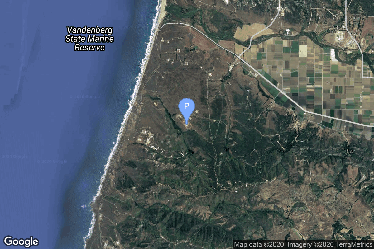
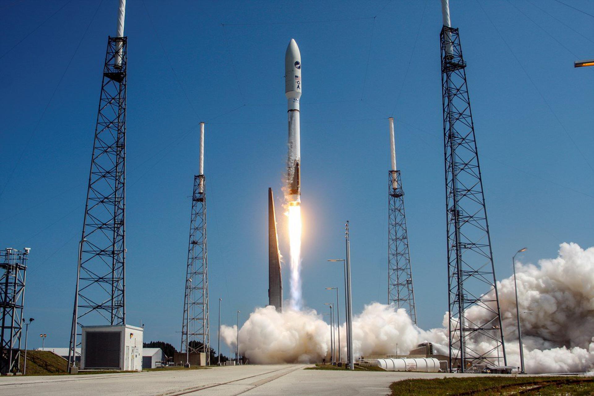
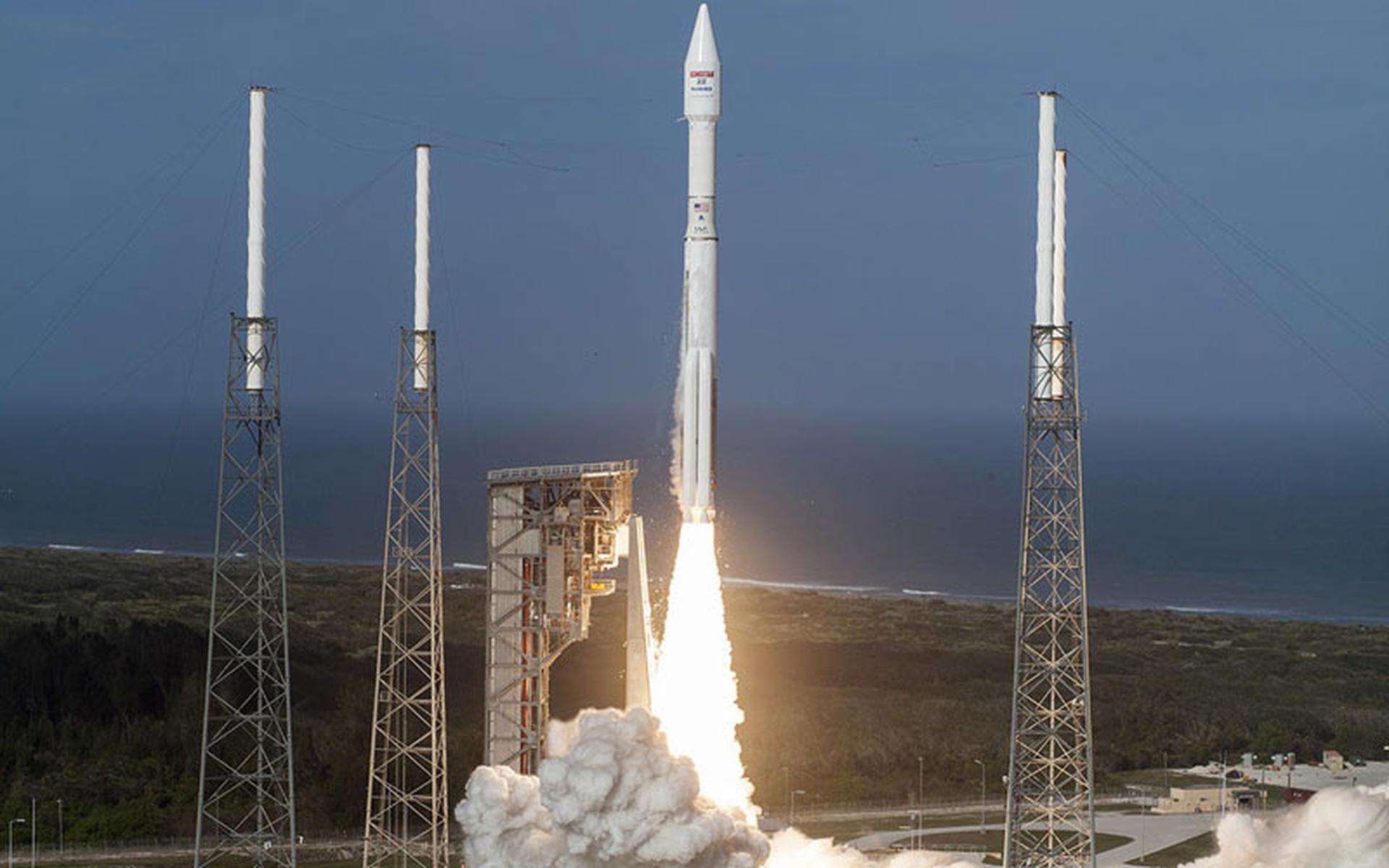
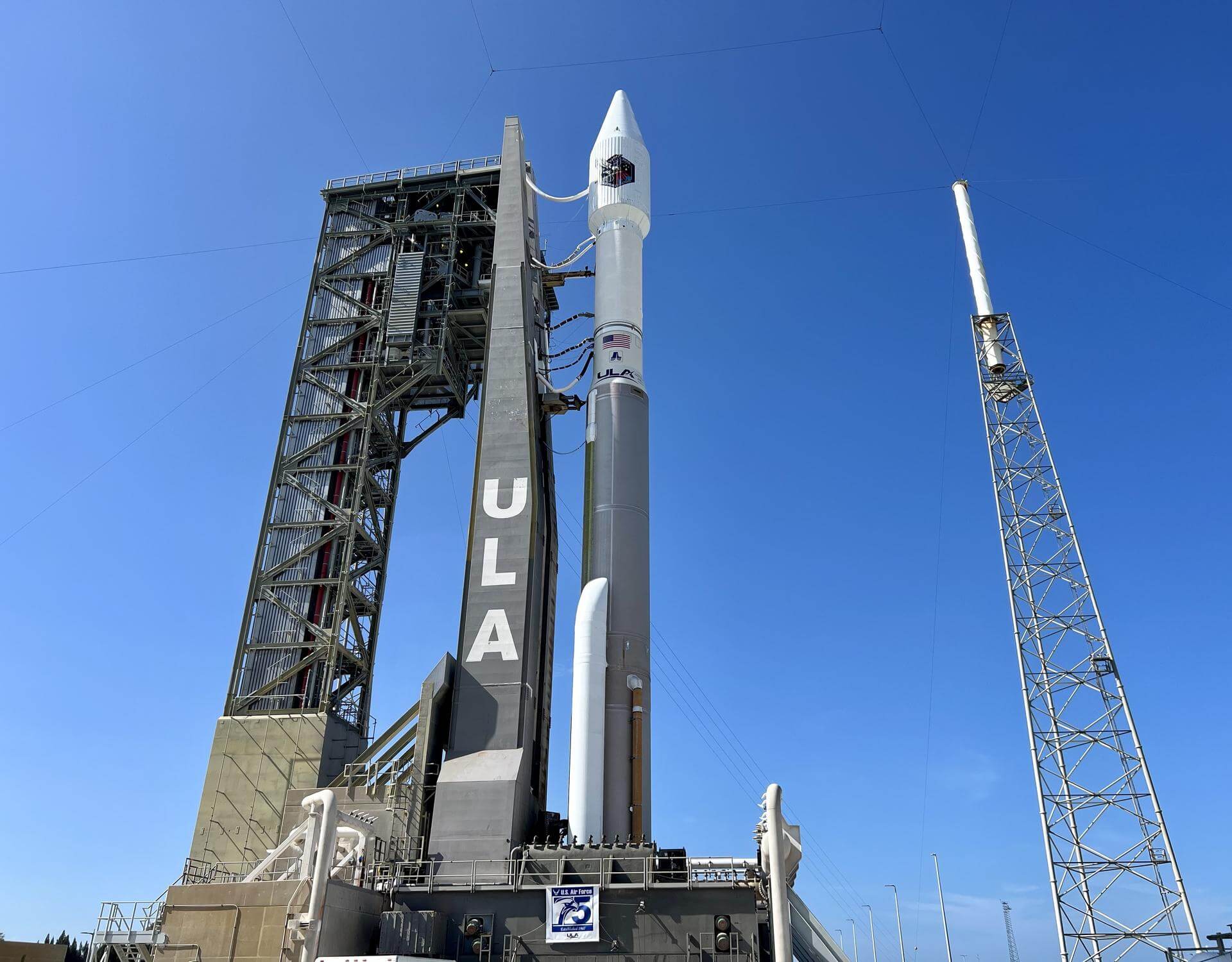
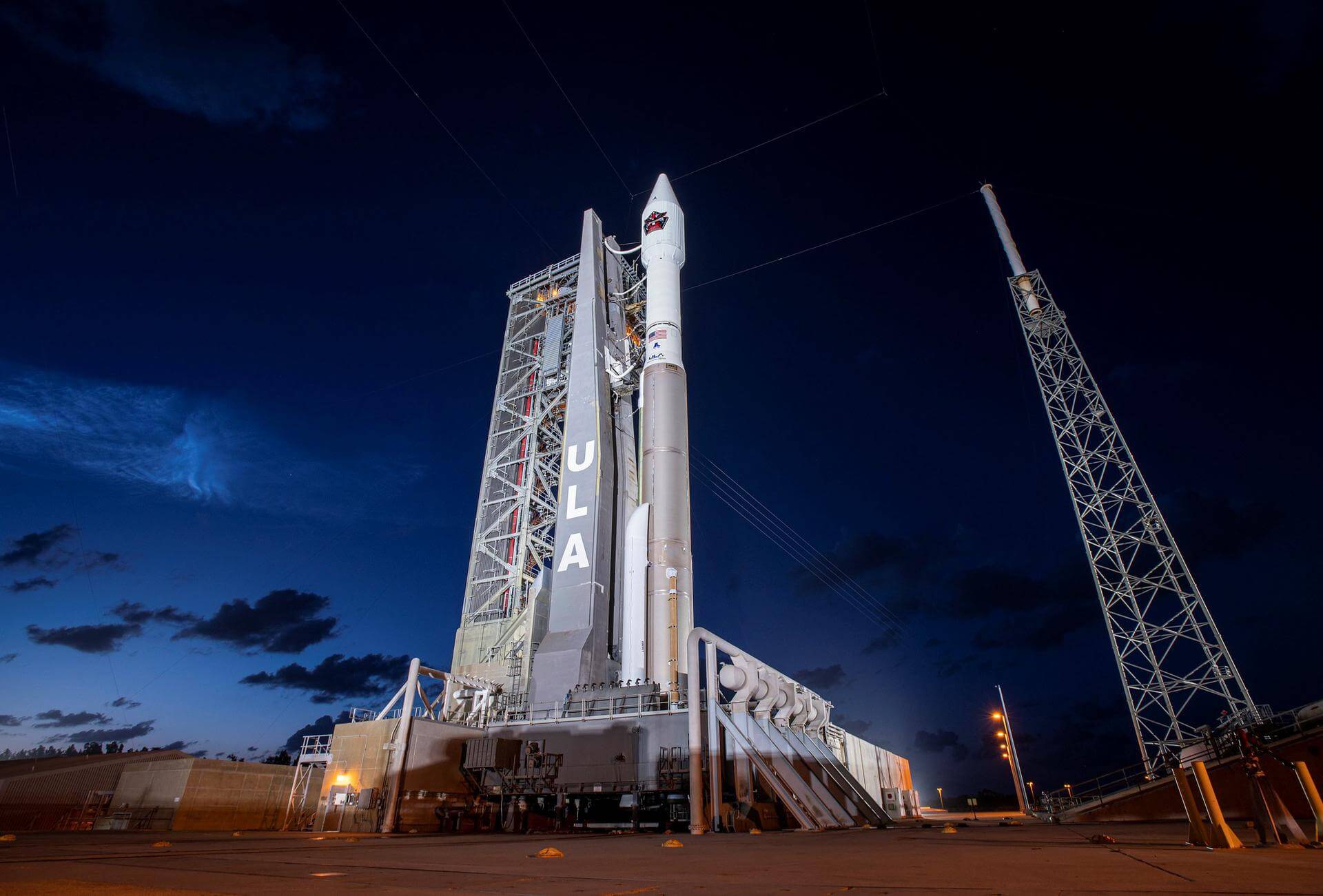
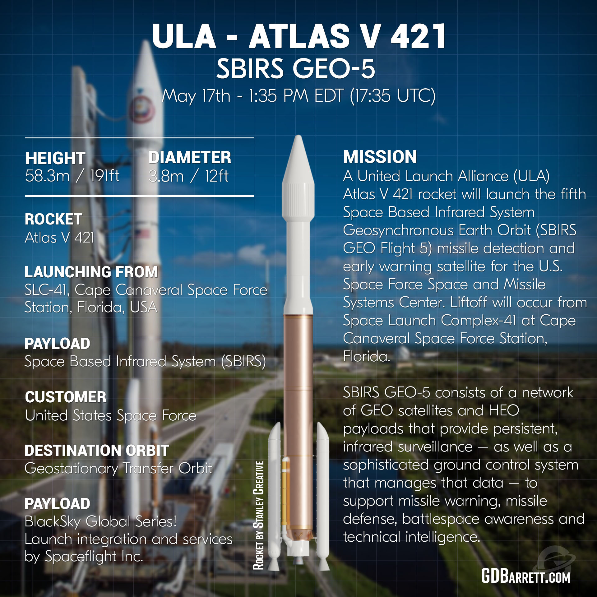
{ "count": 7503, "next": "https://ll.thespacedevs.com/2.0.0/launch/?format=api&limit=10&offset=6780&ordering=-name", "previous": "https://ll.thespacedevs.com/2.0.0/launch/?format=api&limit=10&offset=6760&ordering=-name", "results": [ { "id": "bc5acb5d-f282-4b92-9850-8a097221f94f", "url": "https://ll.thespacedevs.com/2.0.0/launch/bc5acb5d-f282-4b92-9850-8a097221f94f/?format=api", "launch_library_id": 588, "slug": "atlas-v-501-nrol-39-usa-247", "name": "Atlas V 501 | NROL-39 (USA-247)", "status": { "id": 3, "name": "Success" }, "net": "2013-12-06T07:14:30Z", "window_end": "2013-12-06T07:14:30Z", "window_start": "2013-12-06T07:14:30Z", "inhold": false, "tbdtime": false, "tbddate": false, "probability": -1, "holdreason": "", "failreason": null, "hashtag": null, "launch_service_provider": { "id": 124, "url": "https://ll.thespacedevs.com/2.0.0/agencies/124/?format=api", "name": "United Launch Alliance", "type": "Commercial" }, "rocket": { "id": 1724, "configuration": { "id": 4, "launch_library_id": 32, "url": "https://ll.thespacedevs.com/2.0.0/config/launcher/4/?format=api", "name": "Atlas V 501", "family": "Atlas", "full_name": "Atlas V 501", "variant": "501" } }, "mission": { "id": 267, "launch_library_id": 573, "name": "NROL-39 (USA-247)", "description": "Classified payload for the U.S. National Reconnaissance Office.", "launch_designator": null, "type": "Government/Top Secret", "orbit": { "id": 17, "name": "Sun-Synchronous Orbit", "abbrev": "SSO" } }, "pad": { "id": 24, "url": "https://ll.thespacedevs.com/2.0.0/pad/24/?format=api", "agency_id": 161, "name": "Space Launch Complex 3E", "info_url": null, "wiki_url": "https://en.wikipedia.org/wiki/Vandenberg_Space_Launch_Complex_3#SLC-3E", "map_url": "https://www.google.com/maps?q=34.64,-120.5895", "latitude": "34.64", "longitude": "-120.5895", "location": { "id": 11, "url": "https://ll.thespacedevs.com/2.0.0/location/11/?format=api", "name": "Vandenberg SFB, CA, USA", "country_code": "USA", "map_image": "https://thespacedevs-prod.nyc3.digitaloceanspaces.com/media/map_images/location_11_20200803142416.jpg", "total_launch_count": 807, "total_landing_count": 26 }, "map_image": "https://thespacedevs-prod.nyc3.digitaloceanspaces.com/media/map_images/pad_24_20200803143552.jpg", "total_launch_count": 48 }, "webcast_live": false, "image": "https://thespacedevs-prod.nyc3.digitaloceanspaces.com/media/images/atlas2520v2520501_image_20190222030851.jpeg", "infographic": null, "program": [] }, { "id": "67e443c9-8209-4167-b54c-9b46dceca275", "url": "https://ll.thespacedevs.com/2.0.0/launch/67e443c9-8209-4167-b54c-9b46dceca275/?format=api", "launch_library_id": 1568, "slug": "atlas-v-431-intelsat-14", "name": "Atlas V 431 | Intelsat 14", "status": { "id": 3, "name": "Success" }, "net": "2009-11-23T06:55:00Z", "window_end": "2009-11-23T06:55:00Z", "window_start": "2009-11-23T06:55:00Z", "inhold": false, "tbdtime": false, "tbddate": false, "probability": 0, "holdreason": "", "failreason": "", "hashtag": "", "launch_service_provider": { "id": 124, "url": "https://ll.thespacedevs.com/2.0.0/agencies/124/?format=api", "name": "United Launch Alliance", "type": "Commercial" }, "rocket": { "id": 1434, "configuration": { "id": 111, "launch_library_id": 119, "url": "https://ll.thespacedevs.com/2.0.0/config/launcher/111/?format=api", "name": "Atlas V 431", "family": "Atlas", "full_name": "Atlas V 431", "variant": "431" } }, "mission": { "id": 556, "launch_library_id": 725, "name": "Intelsat 14", "description": "A commercial communications satellite owned and operated by Intelsat.", "launch_designator": null, "type": "Communications", "orbit": { "id": 2, "name": "Geostationary Transfer Orbit", "abbrev": "GTO" } }, "pad": { "id": 29, "url": "https://ll.thespacedevs.com/2.0.0/pad/29/?format=api", "agency_id": null, "name": "Space Launch Complex 41", "info_url": null, "wiki_url": "https://en.wikipedia.org/wiki/Cape_Canaveral_Air_Force_Station_Space_Launch_Complex_41", "map_url": "https://www.google.com/maps?q=28.58341025,-80.58303644", "latitude": "28.58341025", "longitude": "-80.58303644", "location": { "id": 12, "url": "https://ll.thespacedevs.com/2.0.0/location/12/?format=api", "name": "Cape Canaveral SFS, FL, USA", "country_code": "USA", "map_image": "https://thespacedevs-prod.nyc3.digitaloceanspaces.com/media/map_images/location_12_20200803142519.jpg", "total_launch_count": 1023, "total_landing_count": 64 }, "map_image": "https://thespacedevs-prod.nyc3.digitaloceanspaces.com/media/map_images/pad_29_20200803143528.jpg", "total_launch_count": 115 }, "webcast_live": false, "image": "https://thespacedevs-prod.nyc3.digitaloceanspaces.com/media/images/atlas2520v2520431_image_20190222031015.jpeg", "infographic": null, "program": [] }, { "id": "57d8217f-5cc3-476f-b688-9dba65e8f988", "url": "https://ll.thespacedevs.com/2.0.0/launch/57d8217f-5cc3-476f-b688-9dba65e8f988/?format=api", "launch_library_id": null, "slug": "atlas-v-431-inmarsat-4-f1", "name": "Atlas V 431 | INMARSAT 4 F1", "status": { "id": 3, "name": "Success" }, "net": "2005-03-11T21:42:00Z", "window_end": "2005-03-11T21:42:00Z", "window_start": "2005-03-11T21:42:00Z", "inhold": false, "tbdtime": false, "tbddate": false, "probability": null, "holdreason": "", "failreason": null, "hashtag": null, "launch_service_provider": { "id": 82, "url": "https://ll.thespacedevs.com/2.0.0/agencies/82/?format=api", "name": "Lockheed Martin", "type": "Commercial" }, "rocket": { "id": 7218, "configuration": { "id": 111, "launch_library_id": 119, "url": "https://ll.thespacedevs.com/2.0.0/config/launcher/111/?format=api", "name": "Atlas V 431", "family": "Atlas", "full_name": "Atlas V 431", "variant": "431" } }, "mission": { "id": 5607, "launch_library_id": null, "name": "INMARSAT 4 F1", "description": "Heaviest single payload to geosynchronous transfer orbit to that date. The satellite was to provide L-band mobile communications and wideband data transmission for Inmarsat's global network.", "launch_designator": null, "type": "Communications", "orbit": { "id": 4, "name": "Geosynchronous Transfer Orbit", "abbrev": "GSTO" } }, "pad": { "id": 29, "url": "https://ll.thespacedevs.com/2.0.0/pad/29/?format=api", "agency_id": null, "name": "Space Launch Complex 41", "info_url": null, "wiki_url": "https://en.wikipedia.org/wiki/Cape_Canaveral_Air_Force_Station_Space_Launch_Complex_41", "map_url": "https://www.google.com/maps?q=28.58341025,-80.58303644", "latitude": "28.58341025", "longitude": "-80.58303644", "location": { "id": 12, "url": "https://ll.thespacedevs.com/2.0.0/location/12/?format=api", "name": "Cape Canaveral SFS, FL, USA", "country_code": "USA", "map_image": "https://thespacedevs-prod.nyc3.digitaloceanspaces.com/media/map_images/location_12_20200803142519.jpg", "total_launch_count": 1023, "total_landing_count": 64 }, "map_image": "https://thespacedevs-prod.nyc3.digitaloceanspaces.com/media/map_images/pad_29_20200803143528.jpg", "total_launch_count": 115 }, "webcast_live": false, "image": "https://thespacedevs-prod.nyc3.digitaloceanspaces.com/media/images/atlas2520v2520431_image_20190222031015.jpeg", "infographic": null, "program": [] }, { "id": "6e7316e1-9e03-411d-a39f-c28e20e18a91", "url": "https://ll.thespacedevs.com/2.0.0/launch/6e7316e1-9e03-411d-a39f-c28e20e18a91/?format=api", "launch_library_id": 766, "slug": "atlas-v-431-echostar-19-jupiter-2", "name": "Atlas V 431 | Echostar 19 (Jupiter-2)", "status": { "id": 3, "name": "Success" }, "net": "2016-12-18T19:13:00Z", "window_end": "2016-12-18T20:27:00Z", "window_start": "2016-12-18T18:27:00Z", "inhold": false, "tbdtime": false, "tbddate": false, "probability": 70, "holdreason": "", "failreason": null, "hashtag": null, "launch_service_provider": { "id": 124, "url": "https://ll.thespacedevs.com/2.0.0/agencies/124/?format=api", "name": "United Launch Alliance", "type": "Commercial" }, "rocket": { "id": 1974, "configuration": { "id": 111, "launch_library_id": 119, "url": "https://ll.thespacedevs.com/2.0.0/config/launcher/111/?format=api", "name": "Atlas V 431", "family": "Atlas", "full_name": "Atlas V 431", "variant": "431" } }, "mission": { "id": 286, "launch_library_id": 389, "name": "Echostar 19 (Jupiter-2)", "description": "Echostar-19, also known as Jupiter-2, is a world’s highest capacity broadband satellite that will help meet the growing demand for HughesNet high-speed satellite internet service in North America. The satellite is designed to provide service for 15 years or more.", "launch_designator": null, "type": "Communications", "orbit": { "id": 2, "name": "Geostationary Transfer Orbit", "abbrev": "GTO" } }, "pad": { "id": 29, "url": "https://ll.thespacedevs.com/2.0.0/pad/29/?format=api", "agency_id": null, "name": "Space Launch Complex 41", "info_url": null, "wiki_url": "https://en.wikipedia.org/wiki/Cape_Canaveral_Air_Force_Station_Space_Launch_Complex_41", "map_url": "https://www.google.com/maps?q=28.58341025,-80.58303644", "latitude": "28.58341025", "longitude": "-80.58303644", "location": { "id": 12, "url": "https://ll.thespacedevs.com/2.0.0/location/12/?format=api", "name": "Cape Canaveral SFS, FL, USA", "country_code": "USA", "map_image": "https://thespacedevs-prod.nyc3.digitaloceanspaces.com/media/map_images/location_12_20200803142519.jpg", "total_launch_count": 1023, "total_landing_count": 64 }, "map_image": "https://thespacedevs-prod.nyc3.digitaloceanspaces.com/media/map_images/pad_29_20200803143528.jpg", "total_launch_count": 115 }, "webcast_live": false, "image": "https://thespacedevs-prod.nyc3.digitaloceanspaces.com/media/images/atlas2520v2520431_image_20190222031015.jpeg", "infographic": null, "program": [] }, { "id": "a381436d-c846-4572-9d53-758a1ad01879", "url": "https://ll.thespacedevs.com/2.0.0/launch/a381436d-c846-4572-9d53-758a1ad01879/?format=api", "launch_library_id": 1564, "slug": "atlas-v-421-wgs-2", "name": "Atlas V 421 | WGS-2", "status": { "id": 3, "name": "Success" }, "net": "2009-04-04T00:31:00Z", "window_end": "2009-04-04T00:31:00Z", "window_start": "2009-04-04T00:31:00Z", "inhold": false, "tbdtime": false, "tbddate": false, "probability": 0, "holdreason": "", "failreason": "", "hashtag": "", "launch_service_provider": { "id": 124, "url": "https://ll.thespacedevs.com/2.0.0/agencies/124/?format=api", "name": "United Launch Alliance", "type": "Commercial" }, "rocket": { "id": 1413, "configuration": { "id": 28, "launch_library_id": 55, "url": "https://ll.thespacedevs.com/2.0.0/config/launcher/28/?format=api", "name": "Atlas V 421", "family": "Atlas", "full_name": "Atlas V 421", "variant": "421" } }, "mission": { "id": 550, "launch_library_id": 721, "name": "WGS-2", "description": "The Wideband Global SATCOM system (WGS) is a high capacity satellite communications system for use by US DoD and Australian Department of Defence. Providing communications for warfighters.", "launch_designator": null, "type": "Communications", "orbit": { "id": 2, "name": "Geostationary Transfer Orbit", "abbrev": "GTO" } }, "pad": { "id": 29, "url": "https://ll.thespacedevs.com/2.0.0/pad/29/?format=api", "agency_id": null, "name": "Space Launch Complex 41", "info_url": null, "wiki_url": "https://en.wikipedia.org/wiki/Cape_Canaveral_Air_Force_Station_Space_Launch_Complex_41", "map_url": "https://www.google.com/maps?q=28.58341025,-80.58303644", "latitude": "28.58341025", "longitude": "-80.58303644", "location": { "id": 12, "url": "https://ll.thespacedevs.com/2.0.0/location/12/?format=api", "name": "Cape Canaveral SFS, FL, USA", "country_code": "USA", "map_image": "https://thespacedevs-prod.nyc3.digitaloceanspaces.com/media/map_images/location_12_20200803142519.jpg", "total_launch_count": 1023, "total_landing_count": 64 }, "map_image": "https://thespacedevs-prod.nyc3.digitaloceanspaces.com/media/map_images/pad_29_20200803143528.jpg", "total_launch_count": 115 }, "webcast_live": false, "image": "https://thespacedevs-prod.nyc3.digitaloceanspaces.com/media/images/atlas_v_421_image_20210519053741.jpeg", "infographic": null, "program": [] }, { "id": "aaaa4478-ff53-49e3-8dfb-2c74b197a73a", "url": "https://ll.thespacedevs.com/2.0.0/launch/aaaa4478-ff53-49e3-8dfb-2c74b197a73a/?format=api", "launch_library_id": 1560, "slug": "atlas-v-421-wgs-1", "name": "Atlas V 421 | WGS-1", "status": { "id": 3, "name": "Success" }, "net": "2007-10-11T00:22:00Z", "window_end": "2007-10-11T00:22:00Z", "window_start": "2007-10-11T00:22:00Z", "inhold": false, "tbdtime": false, "tbddate": false, "probability": 0, "holdreason": "", "failreason": "", "hashtag": "", "launch_service_provider": { "id": 124, "url": "https://ll.thespacedevs.com/2.0.0/agencies/124/?format=api", "name": "United Launch Alliance", "type": "Commercial" }, "rocket": { "id": 550, "configuration": { "id": 28, "launch_library_id": 55, "url": "https://ll.thespacedevs.com/2.0.0/config/launcher/28/?format=api", "name": "Atlas V 421", "family": "Atlas", "full_name": "Atlas V 421", "variant": "421" } }, "mission": { "id": 546, "launch_library_id": 717, "name": "WGS-1", "description": "The Wideband Global SATCOM system (WGS) is a high capacity satellite communications system for use by US DoD and Australian Department of Defence. Providing communications for warfighters.", "launch_designator": null, "type": "Communications", "orbit": { "id": 2, "name": "Geostationary Transfer Orbit", "abbrev": "GTO" } }, "pad": { "id": 29, "url": "https://ll.thespacedevs.com/2.0.0/pad/29/?format=api", "agency_id": null, "name": "Space Launch Complex 41", "info_url": null, "wiki_url": "https://en.wikipedia.org/wiki/Cape_Canaveral_Air_Force_Station_Space_Launch_Complex_41", "map_url": "https://www.google.com/maps?q=28.58341025,-80.58303644", "latitude": "28.58341025", "longitude": "-80.58303644", "location": { "id": 12, "url": "https://ll.thespacedevs.com/2.0.0/location/12/?format=api", "name": "Cape Canaveral SFS, FL, USA", "country_code": "USA", "map_image": "https://thespacedevs-prod.nyc3.digitaloceanspaces.com/media/map_images/location_12_20200803142519.jpg", "total_launch_count": 1023, "total_landing_count": 64 }, "map_image": "https://thespacedevs-prod.nyc3.digitaloceanspaces.com/media/map_images/pad_29_20200803143528.jpg", "total_launch_count": 115 }, "webcast_live": false, "image": "https://thespacedevs-prod.nyc3.digitaloceanspaces.com/media/images/atlas_v_421_image_20210519053741.jpeg", "infographic": null, "program": [] }, { "id": "33bf26a0-818e-4519-a47a-4fe79a07e84e", "url": "https://ll.thespacedevs.com/2.0.0/launch/33bf26a0-818e-4519-a47a-4fe79a07e84e/?format=api", "launch_library_id": 1691, "slug": "atlas-v-421-sbirs-geo-6", "name": "Atlas V 421 | SBIRS GEO-6", "status": { "id": 3, "name": "Success" }, "net": "2022-08-04T10:29:00Z", "window_end": "2022-08-04T11:09:00Z", "window_start": "2022-08-04T10:29:00Z", "inhold": false, "tbdtime": false, "tbddate": false, "probability": 80, "holdreason": "", "failreason": "", "hashtag": null, "launch_service_provider": { "id": 124, "url": "https://ll.thespacedevs.com/2.0.0/agencies/124/?format=api", "name": "United Launch Alliance", "type": "Commercial" }, "rocket": { "id": 2229, "configuration": { "id": 28, "launch_library_id": 55, "url": "https://ll.thespacedevs.com/2.0.0/config/launcher/28/?format=api", "name": "Atlas V 421", "family": "Atlas", "full_name": "Atlas V 421", "variant": "421" } }, "mission": { "id": 6088, "launch_library_id": null, "name": "SBIRS GEO-6", "description": "Sixth geosynchronous satellite of the Space Based Infrared System program (SBIRS), providing capabilities for early missile warning and missile defense. SBIRS GEO-6 is the second satellite using Lockheed Martin's LM2100 combat bus.", "launch_designator": null, "type": "Government/Top Secret", "orbit": { "id": 2, "name": "Geostationary Transfer Orbit", "abbrev": "GTO" } }, "pad": { "id": 29, "url": "https://ll.thespacedevs.com/2.0.0/pad/29/?format=api", "agency_id": null, "name": "Space Launch Complex 41", "info_url": null, "wiki_url": "https://en.wikipedia.org/wiki/Cape_Canaveral_Air_Force_Station_Space_Launch_Complex_41", "map_url": "https://www.google.com/maps?q=28.58341025,-80.58303644", "latitude": "28.58341025", "longitude": "-80.58303644", "location": { "id": 12, "url": "https://ll.thespacedevs.com/2.0.0/location/12/?format=api", "name": "Cape Canaveral SFS, FL, USA", "country_code": "USA", "map_image": "https://thespacedevs-prod.nyc3.digitaloceanspaces.com/media/map_images/location_12_20200803142519.jpg", "total_launch_count": 1023, "total_landing_count": 64 }, "map_image": "https://thespacedevs-prod.nyc3.digitaloceanspaces.com/media/map_images/pad_29_20200803143528.jpg", "total_launch_count": 115 }, "webcast_live": false, "image": "https://thespacedevs-prod.nyc3.digitaloceanspaces.com/media/images/atlas2520v252_image_20220804055901.jpeg", "infographic": null, "program": [] }, { "id": "137a0935-a14f-4690-9ce2-02c8c2ebd1c5", "url": "https://ll.thespacedevs.com/2.0.0/launch/137a0935-a14f-4690-9ce2-02c8c2ebd1c5/?format=api", "launch_library_id": 1690, "slug": "atlas-v-421-sbirs-geo-5", "name": "Atlas V 421 | SBIRS GEO-5", "status": { "id": 3, "name": "Success" }, "net": "2021-05-18T17:37:00Z", "window_end": "2021-05-18T18:11:00Z", "window_start": "2021-05-18T17:31:00Z", "inhold": false, "tbdtime": false, "tbddate": false, "probability": null, "holdreason": "", "failreason": "", "hashtag": null, "launch_service_provider": { "id": 124, "url": "https://ll.thespacedevs.com/2.0.0/agencies/124/?format=api", "name": "United Launch Alliance", "type": "Commercial" }, "rocket": { "id": 2228, "configuration": { "id": 28, "launch_library_id": 55, "url": "https://ll.thespacedevs.com/2.0.0/config/launcher/28/?format=api", "name": "Atlas V 421", "family": "Atlas", "full_name": "Atlas V 421", "variant": "421" } }, "mission": { "id": 1293, "launch_library_id": null, "name": "SBIRS GEO-5", "description": "Fifth geosynchronous satellite of the Space Based Infrared System program (SBIRS), providing capabilities for early missile warning and missile defense. SBIRS GEO-5 is the first satellite using Lockheed Martin's LM2100 combat bus.", "launch_designator": null, "type": "Government/Top Secret", "orbit": { "id": 2, "name": "Geostationary Transfer Orbit", "abbrev": "GTO" } }, "pad": { "id": 29, "url": "https://ll.thespacedevs.com/2.0.0/pad/29/?format=api", "agency_id": null, "name": "Space Launch Complex 41", "info_url": null, "wiki_url": "https://en.wikipedia.org/wiki/Cape_Canaveral_Air_Force_Station_Space_Launch_Complex_41", "map_url": "https://www.google.com/maps?q=28.58341025,-80.58303644", "latitude": "28.58341025", "longitude": "-80.58303644", "location": { "id": 12, "url": "https://ll.thespacedevs.com/2.0.0/location/12/?format=api", "name": "Cape Canaveral SFS, FL, USA", "country_code": "USA", "map_image": "https://thespacedevs-prod.nyc3.digitaloceanspaces.com/media/map_images/location_12_20200803142519.jpg", "total_launch_count": 1023, "total_landing_count": 64 }, "map_image": "https://thespacedevs-prod.nyc3.digitaloceanspaces.com/media/map_images/pad_29_20200803143528.jpg", "total_launch_count": 115 }, "webcast_live": false, "image": "https://thespacedevs-prod.nyc3.digitaloceanspaces.com/media/images/atlas2520v252_image_20210516172951.jpeg", "infographic": "https://thespacedevs-prod.nyc3.digitaloceanspaces.com/media/infographic_images/atlas2520v252_infographic_20210515005057.jpg", "program": [] }, { "id": "5f59bf95-0c45-418a-a1d4-8a237c6b852b", "url": "https://ll.thespacedevs.com/2.0.0/launch/5f59bf95-0c45-418a-a1d4-8a237c6b852b/?format=api", "launch_library_id": 760, "slug": "atlas-v-421-nrol-61", "name": "Atlas V 421 | NROL-61", "status": { "id": 3, "name": "Success" }, "net": "2016-07-28T12:37:00Z", "window_end": "2016-07-28T16:00:00Z", "window_start": "2016-07-28T12:00:00Z", "inhold": false, "tbdtime": false, "tbddate": false, "probability": 80, "holdreason": "", "failreason": null, "hashtag": null, "launch_service_provider": { "id": 124, "url": "https://ll.thespacedevs.com/2.0.0/agencies/124/?format=api", "name": "United Launch Alliance", "type": "Commercial" }, "rocket": { "id": 1943, "configuration": { "id": 28, "launch_library_id": 55, "url": "https://ll.thespacedevs.com/2.0.0/config/launcher/28/?format=api", "name": "Atlas V 421", "family": "Atlas", "full_name": "Atlas V 421", "variant": "421" } }, "mission": { "id": 120, "launch_library_id": 174, "name": "NROL-61", "description": "Classified payload for the National Reconnaissance Office.", "launch_designator": null, "type": "Government/Top Secret", "orbit": { "id": 2, "name": "Geostationary Transfer Orbit", "abbrev": "GTO" } }, "pad": { "id": 29, "url": "https://ll.thespacedevs.com/2.0.0/pad/29/?format=api", "agency_id": null, "name": "Space Launch Complex 41", "info_url": null, "wiki_url": "https://en.wikipedia.org/wiki/Cape_Canaveral_Air_Force_Station_Space_Launch_Complex_41", "map_url": "https://www.google.com/maps?q=28.58341025,-80.58303644", "latitude": "28.58341025", "longitude": "-80.58303644", "location": { "id": 12, "url": "https://ll.thespacedevs.com/2.0.0/location/12/?format=api", "name": "Cape Canaveral SFS, FL, USA", "country_code": "USA", "map_image": "https://thespacedevs-prod.nyc3.digitaloceanspaces.com/media/map_images/location_12_20200803142519.jpg", "total_launch_count": 1023, "total_landing_count": 64 }, "map_image": "https://thespacedevs-prod.nyc3.digitaloceanspaces.com/media/map_images/pad_29_20200803143528.jpg", "total_launch_count": 115 }, "webcast_live": false, "image": "https://thespacedevs-prod.nyc3.digitaloceanspaces.com/media/images/atlas_v_421_image_20210519053741.jpeg", "infographic": null, "program": [] }, { "id": "a444a545-cd97-40c4-90e3-a4b4ab896afa", "url": "https://ll.thespacedevs.com/2.0.0/launch/a444a545-cd97-40c4-90e3-a4b4ab896afa/?format=api", "launch_library_id": 1287, "slug": "atlas-v-421-nrol-52", "name": "Atlas V 421 | NROL-52", "status": { "id": 3, "name": "Success" }, "net": "2017-10-15T07:28:00Z", "window_end": "2017-10-15T07:28:00Z", "window_start": "2017-10-15T07:28:00Z", "inhold": false, "tbdtime": false, "tbddate": false, "probability": 80, "holdreason": "", "failreason": null, "hashtag": "", "launch_service_provider": { "id": 124, "url": "https://ll.thespacedevs.com/2.0.0/agencies/124/?format=api", "name": "United Launch Alliance", "type": "Commercial" }, "rocket": { "id": 2040, "configuration": { "id": 28, "launch_library_id": 55, "url": "https://ll.thespacedevs.com/2.0.0/config/launcher/28/?format=api", "name": "Atlas V 421", "family": "Atlas", "full_name": "Atlas V 421", "variant": "421" } }, "mission": { "id": 133, "launch_library_id": 570, "name": "NROL-52", "description": "Classified payload for the U.S. National Reconnaissance Office.", "launch_designator": null, "type": "Government/Top Secret", "orbit": { "id": 2, "name": "Geostationary Transfer Orbit", "abbrev": "GTO" } }, "pad": { "id": 29, "url": "https://ll.thespacedevs.com/2.0.0/pad/29/?format=api", "agency_id": null, "name": "Space Launch Complex 41", "info_url": null, "wiki_url": "https://en.wikipedia.org/wiki/Cape_Canaveral_Air_Force_Station_Space_Launch_Complex_41", "map_url": "https://www.google.com/maps?q=28.58341025,-80.58303644", "latitude": "28.58341025", "longitude": "-80.58303644", "location": { "id": 12, "url": "https://ll.thespacedevs.com/2.0.0/location/12/?format=api", "name": "Cape Canaveral SFS, FL, USA", "country_code": "USA", "map_image": "https://thespacedevs-prod.nyc3.digitaloceanspaces.com/media/map_images/location_12_20200803142519.jpg", "total_launch_count": 1023, "total_landing_count": 64 }, "map_image": "https://thespacedevs-prod.nyc3.digitaloceanspaces.com/media/map_images/pad_29_20200803143528.jpg", "total_launch_count": 115 }, "webcast_live": false, "image": "https://thespacedevs-prod.nyc3.digitaloceanspaces.com/media/images/atlas_v_421_image_20210519053741.jpeg", "infographic": null, "program": [] } ] }