Launch List
API endpoint that returns all Launch objects or a single launch.
EXAMPLE - /launch/
GET: Return a list of all Launch objects.
FILTERS: Fields - 'name', 'id(s)', 'lsp_id', 'lsp_name', 'serial_number', 'launcher_config__id', 'rocket__spacecraftflight__spacecraft__name'
MODE: 'normal', 'list', 'detailed' EXAMPLE: ?mode=list
SEARCH: Searches through the launch name, rocket name, launch agency, mission name & spacecraft name. EXAMPLE - ?search=SpaceX
GET /2.0.0/launch/?format=api&offset=600&ordering=-name
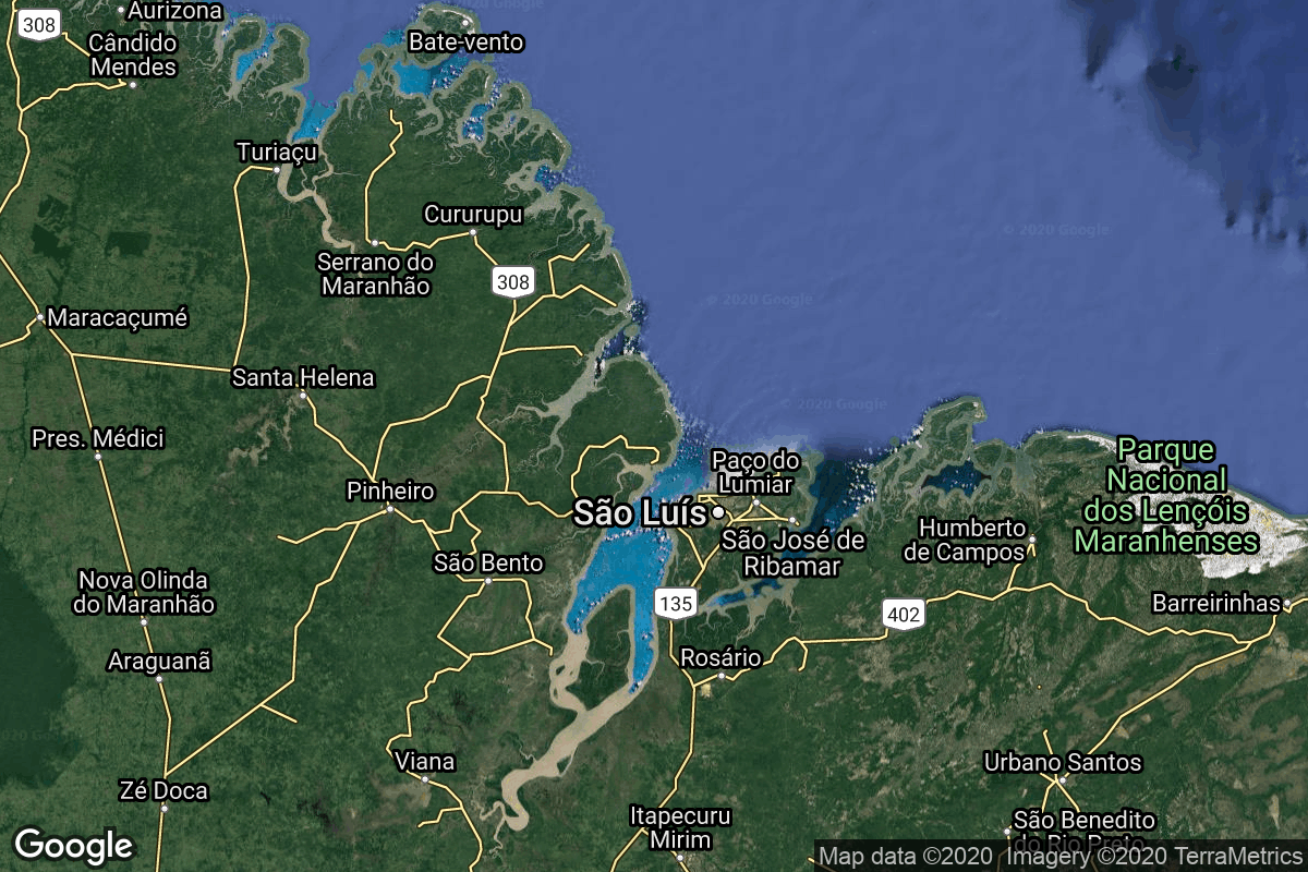
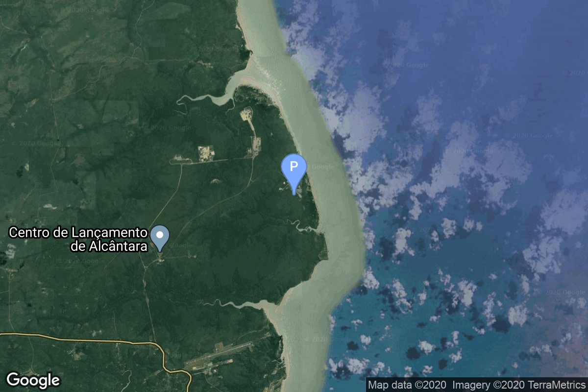
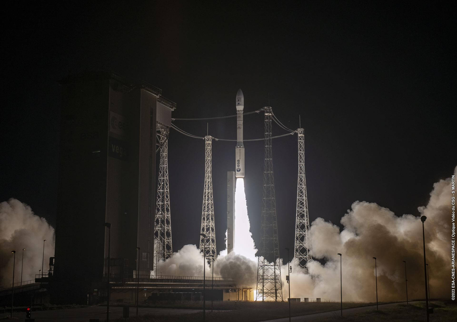
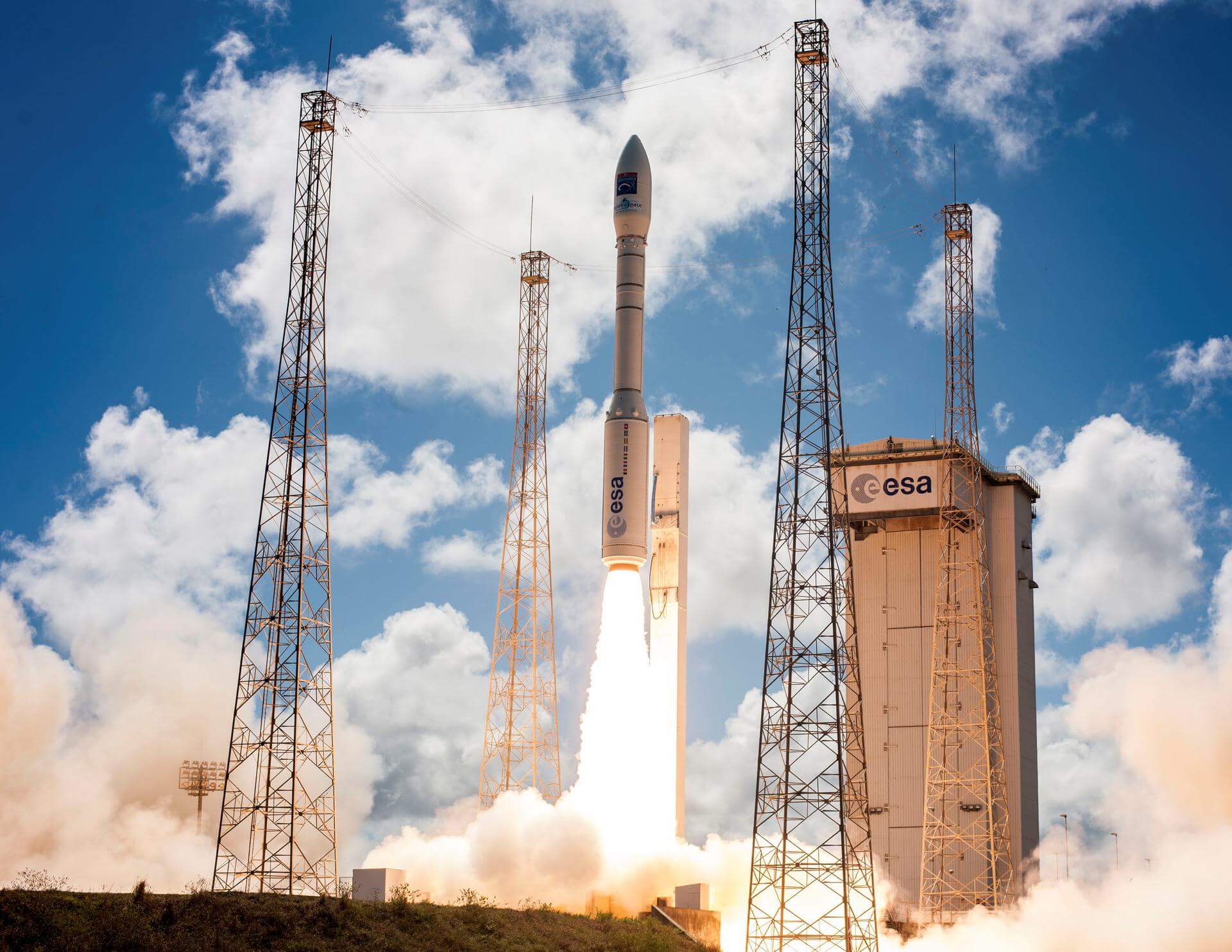
{ "count": 7668, "next": "https://ll.thespacedevs.com/2.0.0/launch/?format=api&limit=10&offset=610&ordering=-name", "previous": "https://ll.thespacedevs.com/2.0.0/launch/?format=api&limit=10&offset=590&ordering=-name", "results": [ { "id": "008b4d60-d702-4a99-ad2f-431ff1027831", "url": "https://ll.thespacedevs.com/2.0.0/launch/008b4d60-d702-4a99-ad2f-431ff1027831/?format=api", "launch_library_id": null, "slug": "voskhod-ds-p1-yu-40", "name": "Voskhod | DS-P1-Yu 40", "status": { "id": 4, "name": "Failure" }, "net": "1971-03-05T01:02:03Z", "window_end": "1971-03-05T01:02:03Z", "window_start": "1971-03-05T01:02:03Z", "inhold": false, "tbdtime": false, "tbddate": false, "probability": null, "holdreason": "", "failreason": null, "hashtag": null, "launch_service_provider": { "id": 66, "url": "https://ll.thespacedevs.com/2.0.0/agencies/66/?format=api", "name": "Soviet Space Program", "type": "Government" }, "rocket": { "id": 4109, "configuration": { "id": 104, "launch_library_id": 138, "url": "https://ll.thespacedevs.com/2.0.0/config/launcher/104/?format=api", "name": "Voskhod", "family": "R-7", "full_name": "Voskhod", "variant": "Voskhod" } }, "mission": { "id": 2527, "launch_library_id": null, "name": "DS-P1-Yu 40", "description": "The DS-P1-Yu series of satellites was used to calibrate space surveillance and early warning radars.", "launch_designator": null, "type": "Test Target", "orbit": { "id": 8, "name": "Low Earth Orbit", "abbrev": "LEO" } }, "pad": { "id": 85, "url": "https://ll.thespacedevs.com/2.0.0/pad/85/?format=api", "agency_id": 163, "name": "43/4 (43R)", "info_url": null, "wiki_url": null, "map_url": "https://www.google.com/maps?q=62.92883,40.457098", "latitude": "62.92883", "longitude": "40.457098", "location": { "id": 6, "url": "https://ll.thespacedevs.com/2.0.0/location/6/?format=api", "name": "Plesetsk Cosmodrome, Russian Federation", "country_code": "RUS", "map_image": "https://thespacedevs-prod.nyc3.digitaloceanspaces.com/media/map_images/location_6_20200803142434.jpg", "total_launch_count": 1678, "total_landing_count": 0 }, "map_image": "https://thespacedevs-prod.nyc3.digitaloceanspaces.com/media/map_images/pad_85_20200803143554.jpg", "total_launch_count": 324 }, "webcast_live": false, "image": "https://thespacedevs-prod.nyc3.digitaloceanspaces.com/media/images/voskhod_during__image_20251102062248.jpg", "infographic": null, "program": [] }, { "id": "f49d890e-09a1-4627-91fd-ac4884a5bd51", "url": "https://ll.thespacedevs.com/2.0.0/launch/f49d890e-09a1-4627-91fd-ac4884a5bd51/?format=api", "launch_library_id": null, "slug": "volna-cosmos-1", "name": "Volna | Cosmos-1", "status": { "id": 4, "name": "Failure" }, "net": "2005-06-21T19:46:09Z", "window_end": "2005-06-21T19:46:09Z", "window_start": "2005-06-21T19:46:09Z", "inhold": false, "tbdtime": false, "tbddate": false, "probability": null, "holdreason": "", "failreason": null, "hashtag": null, "launch_service_provider": { "id": 1013, "url": "https://ll.thespacedevs.com/2.0.0/agencies/1013/?format=api", "name": "Makeyev Rocket Design Bureau", "type": "Commercial" }, "rocket": { "id": 7230, "configuration": { "id": 450, "launch_library_id": null, "url": "https://ll.thespacedevs.com/2.0.0/config/launcher/450/?format=api", "name": "Volna", "family": "", "full_name": "Volna", "variant": "" } }, "mission": { "id": 5619, "launch_library_id": null, "name": "Cosmos-1", "description": "Cosmos 1 was a project by Cosmos Studios and The Planetary Society to test a solar sail in space. As part of the project, an unmanned solar-sail spacecraft named Cosmos 1 was launched into space at 15:46:09 EDT (19:46:09 UTC) on June 21, 2005 from the submarine Borisoglebsk in the Barents Sea. However, a rocket failure prevented the spacecraft from reaching its intended orbit.", "launch_designator": null, "type": "Earth Science", "orbit": { "id": 8, "name": "Low Earth Orbit", "abbrev": "LEO" } }, "pad": { "id": 148, "url": "https://ll.thespacedevs.com/2.0.0/pad/148/?format=api", "agency_id": null, "name": "Borisoglebsk (K-496)", "info_url": null, "wiki_url": "https://en.wikipedia.org/wiki/Russian_submarine_Borisoglebsk_(K-496)", "map_url": "https://www.google.com/maps?q=74.0000,38.0000", "latitude": "74.0", "longitude": "38.0", "location": { "id": 3, "url": "https://ll.thespacedevs.com/2.0.0/location/3/?format=api", "name": "Sea Launch", "country_code": "???", "map_image": "https://thespacedevs-prod.nyc3.digitaloceanspaces.com/media/map_images/location_3_20200803142448.jpg", "total_launch_count": 60, "total_landing_count": 0 }, "map_image": "https://thespacedevs-prod.nyc3.digitaloceanspaces.com/media/map_images/pad_148_20200803143426.jpg", "total_launch_count": 1 }, "webcast_live": false, "image": null, "infographic": null, "program": [] }, { "id": "15183b48-9462-4eb7-b24e-eb6286605bb1", "url": "https://ll.thespacedevs.com/2.0.0/launch/15183b48-9462-4eb7-b24e-eb6286605bb1/?format=api", "launch_library_id": null, "slug": "vls-1-scd-2a", "name": "VLS-1 | SCD-2A", "status": { "id": 4, "name": "Failure" }, "net": "1997-11-02T12:25:00Z", "window_end": "1997-11-02T12:25:00Z", "window_start": "1997-11-02T12:25:00Z", "inhold": false, "tbdtime": false, "tbddate": false, "probability": null, "holdreason": "", "failreason": null, "hashtag": null, "launch_service_provider": { "id": 12, "url": "https://ll.thespacedevs.com/2.0.0/agencies/12/?format=api", "name": "Brazilian Space Agency", "type": "Government" }, "rocket": { "id": 6814, "configuration": { "id": 448, "launch_library_id": null, "url": "https://ll.thespacedevs.com/2.0.0/config/launcher/448/?format=api", "name": "VLS-1", "family": "", "full_name": "VLS-1", "variant": "1" } }, "mission": { "id": 5204, "launch_library_id": null, "name": "SCD-2A", "description": "The satellites of the SCD (Satelites de Coleta de Dados) series are equipped to collect and transmit meteorological and environmental data collected by automatic platforms (PCD) installed on land or on oceanic buoys. The data is relayed to one or more ground stations.", "launch_designator": null, "type": "Communications", "orbit": { "id": 8, "name": "Low Earth Orbit", "abbrev": "LEO" } }, "pad": { "id": 146, "url": "https://ll.thespacedevs.com/2.0.0/pad/146/?format=api", "agency_id": null, "name": "VLS Pad", "info_url": null, "wiki_url": "https://en.wikipedia.org/wiki/Alc%C3%A2ntara_Launch_Center", "map_url": "https://www.google.com/maps?q=-2.3177,-44.369984", "latitude": "-2.3177", "longitude": "-44.369984", "location": { "id": 150, "url": "https://ll.thespacedevs.com/2.0.0/location/150/?format=api", "name": "Alcântara Space Center, Federative Republic of Brazil", "country_code": "BRA", "map_image": "https://thespacedevs-prod.nyc3.digitaloceanspaces.com/media/map_images/location_150_20200803142405.jpg", "total_launch_count": 3, "total_landing_count": 0 }, "map_image": "https://thespacedevs-prod.nyc3.digitaloceanspaces.com/media/map_images/pad_146_20200803143337.jpg", "total_launch_count": 2 }, "webcast_live": false, "image": "https://thespacedevs-prod.nyc3.digitaloceanspaces.com/media/images/vls1-v03_rocket_image_20251102060306.jpg", "infographic": null, "program": [] }, { "id": "7df36bc5-9d8d-4e69-916a-7261db021967", "url": "https://ll.thespacedevs.com/2.0.0/launch/7df36bc5-9d8d-4e69-916a-7261db021967/?format=api", "launch_library_id": null, "slug": "vls-1-saci-2", "name": "VLS-1 | SACI-2", "status": { "id": 4, "name": "Failure" }, "net": "1999-12-11T18:25:00Z", "window_end": "1999-12-11T18:25:00Z", "window_start": "1999-12-11T18:25:00Z", "inhold": false, "tbdtime": false, "tbddate": false, "probability": null, "holdreason": "", "failreason": null, "hashtag": null, "launch_service_provider": { "id": 12, "url": "https://ll.thespacedevs.com/2.0.0/agencies/12/?format=api", "name": "Brazilian Space Agency", "type": "Government" }, "rocket": { "id": 6957, "configuration": { "id": 448, "launch_library_id": null, "url": "https://ll.thespacedevs.com/2.0.0/config/launcher/448/?format=api", "name": "VLS-1", "family": "", "full_name": "VLS-1", "variant": "1" } }, "mission": { "id": 5346, "launch_library_id": null, "name": "SACI-2", "description": "SACI 2 (Satélite Científico 2) is a 60 kg scientific satellite (Scientific Applications Satellite) launched on the 11th December 1999 on the second flight of the Brazilian VLS-1. Failure of the launcher second stage prevented it from reaching orbit.", "launch_designator": null, "type": "Astrophysics", "orbit": { "id": 8, "name": "Low Earth Orbit", "abbrev": "LEO" } }, "pad": { "id": 146, "url": "https://ll.thespacedevs.com/2.0.0/pad/146/?format=api", "agency_id": null, "name": "VLS Pad", "info_url": null, "wiki_url": "https://en.wikipedia.org/wiki/Alc%C3%A2ntara_Launch_Center", "map_url": "https://www.google.com/maps?q=-2.3177,-44.369984", "latitude": "-2.3177", "longitude": "-44.369984", "location": { "id": 150, "url": "https://ll.thespacedevs.com/2.0.0/location/150/?format=api", "name": "Alcântara Space Center, Federative Republic of Brazil", "country_code": "BRA", "map_image": "https://thespacedevs-prod.nyc3.digitaloceanspaces.com/media/map_images/location_150_20200803142405.jpg", "total_launch_count": 3, "total_landing_count": 0 }, "map_image": "https://thespacedevs-prod.nyc3.digitaloceanspaces.com/media/map_images/pad_146_20200803143337.jpg", "total_launch_count": 2 }, "webcast_live": false, "image": "https://thespacedevs-prod.nyc3.digitaloceanspaces.com/media/images/vls1-v03_rocket_image_20251102060306.jpg", "infographic": null, "program": [] }, { "id": "355ab4b9-504c-49ce-84bf-a6df31a0aadf", "url": "https://ll.thespacedevs.com/2.0.0/launch/355ab4b9-504c-49ce-84bf-a6df31a0aadf/?format=api", "launch_library_id": null, "slug": "vega-theos-2-triton-others", "name": "Vega | THEOS-2, TRITON & others", "status": { "id": 3, "name": "Success" }, "net": "2023-10-09T01:36:25Z", "window_end": "2023-10-09T01:36:25Z", "window_start": "2023-10-09T01:36:25Z", "inhold": false, "tbdtime": false, "tbddate": false, "probability": null, "holdreason": "", "failreason": "", "hashtag": null, "launch_service_provider": { "id": 115, "url": "https://ll.thespacedevs.com/2.0.0/agencies/115/?format=api", "name": "Arianespace", "type": "Commercial" }, "rocket": { "id": 7903, "configuration": { "id": 167, "launch_library_id": 18, "url": "https://ll.thespacedevs.com/2.0.0/config/launcher/167/?format=api", "name": "Vega", "family": "Vega", "full_name": "Vega", "variant": "" } }, "mission": { "id": 6492, "launch_library_id": null, "name": "THEOS-2, TRITON & others", "description": "THEOS-2 is Thailand’s first Earth observation satellite. Built by Airbus Defense and Space and based on the Astrobus-S platform, it is designed for optical measurements with a ground resolution of approximately 1 meter.\r\n\r\nTRITON or FORMOSAT-7R is an additional satellite by NSPO added to the joint Taiwanese-US FORMOSAT 7 / COSMIC-2 constellation for collecting atmospheric data for weather prediction and for ionosphere, climate and gravity research. Its GNSS Reflectometry payload can be used to calculate the wind speed over sea surfaces.\r\n\r\nCubesats:\r\n\r\nPROBA-V-CC (Project for On-Board Autonomy - Vegetation - Companion CubeSat) (12U) is a mission that will fly a scaled-down version of the vegetation-monitoring instrument aboard the Earth-observing PROBA-V to conduct combined experimental observations with its predecessor.\r\n\r\nPRETTY (Passive REflecTomeTry and dosimetrY) (3U) flies a GPS/Galileo signal reflectometer and radiation monitor for Graz University of Technology of Austria.\r\n\r\nMACSAT (6U) is an In-orbit demonstration (IoD) missionto demonstrate IoT communication over 5G for OQTech.\r\n\r\nCSC-1 and 2 (6U) contains 7 different experimental payloads from various institutions being flown by ISISPACE/ISL.\r\n\r\nN3SS (Nanosat 3U pour la Surveillance du Spectre) (3U) is a demonstration system for detecting and\r\nlocalize radio-frequency jammers on civil spectrum for the French CNES.\r\n\r\nESTCUBE-2 is a technology demonstration mission with multiple scientific payloads for University of Tartu of Estonia.\r\n\r\nANSER LEADER/FOLLOWER 1/2 (Advanced\r\nNanosatellite Systems for Earth observation Research) is a cluster of 3 Earth observing cubesats with panchromatic and hyperspectral cameras for Spain's INTA for monitoring the quality of inland (reservoirs) water over the Iberian Peninsula.", "launch_designator": null, "type": "Dedicated Rideshare", "orbit": { "id": 17, "name": "Sun-Synchronous Orbit", "abbrev": "SSO" } }, "pad": { "id": 34, "url": "https://ll.thespacedevs.com/2.0.0/pad/34/?format=api", "agency_id": 115, "name": "Ariane Launch Area 1 (ELV)", "info_url": null, "wiki_url": "https://en.wikipedia.org/wiki/ELA-1", "map_url": "https://www.google.com/maps?q=5.236,-52.775", "latitude": "5.236", "longitude": "-52.775", "location": { "id": 13, "url": "https://ll.thespacedevs.com/2.0.0/location/13/?format=api", "name": "Guiana Space Centre, French Guiana", "country_code": "GUF", "map_image": "https://thespacedevs-prod.nyc3.digitaloceanspaces.com/media/map_images/location_13_20200803142412.jpg", "total_launch_count": 327, "total_landing_count": 0 }, "map_image": "https://thespacedevs-prod.nyc3.digitaloceanspaces.com/media/map_images/pad_34_20200803143527.jpg", "total_launch_count": 53 }, "webcast_live": false, "image": "https://thespacedevs-prod.nyc3.digitaloceanspaces.com/media/images/vega2520257c_image_20231009052620.jpeg", "infographic": null, "program": [] }, { "id": "15468d99-b3eb-4bf4-81b3-3fda9d2e579d", "url": "https://ll.thespacedevs.com/2.0.0/launch/15468d99-b3eb-4bf4-81b3-3fda9d2e579d/?format=api", "launch_library_id": 1321, "slug": "vega-ssms-poc", "name": "Vega | SSMS PoC", "status": { "id": 3, "name": "Success" }, "net": "2020-09-03T01:51:10Z", "window_end": "2020-09-03T01:51:10Z", "window_start": "2020-09-03T01:51:10Z", "inhold": false, "tbdtime": false, "tbddate": false, "probability": null, "holdreason": "", "failreason": null, "hashtag": "#VV16", "launch_service_provider": { "id": 115, "url": "https://ll.thespacedevs.com/2.0.0/agencies/115/?format=api", "name": "Arianespace", "type": "Commercial" }, "rocket": { "id": 57, "configuration": { "id": 167, "launch_library_id": 18, "url": "https://ll.thespacedevs.com/2.0.0/config/launcher/167/?format=api", "name": "Vega", "family": "Vega", "full_name": "Vega", "variant": "" } }, "mission": { "id": 1033, "launch_library_id": 1235, "name": "SSMS POC", "description": "The Vega POC (Proof Of Concept) flight will be the first mission of the SSMS (Small Spacecraft Mission Service), a modular carbon fiber dispenser, a program initiated by ESA in 2016, with the contribution of the European Commission. For all the European partners involved, its purpose is to address the burgeoning institutional and commercial small spacecraft market with a new rideshare concept.\n\nPayload includes dozens of satellites: Athena, ION CubeSat Carrier, ESAIL, NEMO-HD, GHGSat C1, six Flock-v cubesats, several Lemur-2 cubesats, twelve SpaceBEE nanosats, FSSCat A & B, RTAF-Sat, DIDO 3, IGOSat, PICASSO, PINO, PIXL, QARMAN, SIMBA, TRISAT, Casaa-Sat, TTU-100, and more.", "launch_designator": null, "type": "Dedicated Rideshare", "orbit": { "id": 17, "name": "Sun-Synchronous Orbit", "abbrev": "SSO" } }, "pad": { "id": 34, "url": "https://ll.thespacedevs.com/2.0.0/pad/34/?format=api", "agency_id": 115, "name": "Ariane Launch Area 1 (ELV)", "info_url": null, "wiki_url": "https://en.wikipedia.org/wiki/ELA-1", "map_url": "https://www.google.com/maps?q=5.236,-52.775", "latitude": "5.236", "longitude": "-52.775", "location": { "id": 13, "url": "https://ll.thespacedevs.com/2.0.0/location/13/?format=api", "name": "Guiana Space Centre, French Guiana", "country_code": "GUF", "map_image": "https://thespacedevs-prod.nyc3.digitaloceanspaces.com/media/map_images/location_13_20200803142412.jpg", "total_launch_count": 327, "total_landing_count": 0 }, "map_image": "https://thespacedevs-prod.nyc3.digitaloceanspaces.com/media/map_images/pad_34_20200803143527.jpg", "total_launch_count": 53 }, "webcast_live": false, "image": "https://thespacedevs-prod.nyc3.digitaloceanspaces.com/media/images/vega_image_20201111143622.jpeg", "infographic": "https://thespacedevs-prod.nyc3.digitaloceanspaces.com/media/infographic_images/vega2520257c_infographic_20200831230945.png", "program": [] }, { "id": "d9486816-bb61-4b16-bcfa-0d1e9ba40696", "url": "https://ll.thespacedevs.com/2.0.0/launch/d9486816-bb61-4b16-bcfa-0d1e9ba40696/?format=api", "launch_library_id": 1643, "slug": "vega-seosat-ingenio-taranis", "name": "Vega | SEOSAT-Ingenio & Taranis", "status": { "id": 4, "name": "Failure" }, "net": "2020-11-17T01:52:20Z", "window_end": "2020-11-17T01:52:20Z", "window_start": "2020-11-17T01:52:20Z", "inhold": false, "tbdtime": false, "tbddate": false, "probability": null, "holdreason": "", "failreason": "AVUM upper stage tumbled uncontrollably during the first burn because cables in the engine control system were improperly connected.", "hashtag": "#SEOSATIngenio", "launch_service_provider": { "id": 115, "url": "https://ll.thespacedevs.com/2.0.0/agencies/115/?format=api", "name": "Arianespace", "type": "Commercial" }, "rocket": { "id": 2141, "configuration": { "id": 167, "launch_library_id": 18, "url": "https://ll.thespacedevs.com/2.0.0/config/launcher/167/?format=api", "name": "Vega", "family": "Vega", "full_name": "Vega", "variant": "" } }, "mission": { "id": 693, "launch_library_id": 882, "name": "SEOSAT-Ingenio & Taranis", "description": "SEOSAT-Ingenio is a high-resolution optical imaging mission of Spain - the flagship mission of the Spanish space strategic plan. Its mission is devoted to ensure an even coverage of the areas of national interest, providing a large operational capability in the capture of high-resolution multi-spectral land optical images for numerous user groups, as well as supporting and optimizing the development in Spain of teledetection-based applications in Spain. The overall mission objective is to provide information for applications in cartography, land use, urban management, water management, environmental monitoring, risk management and security.\r\n\r\nTARANIS (Tool for the Analysis of RAdiation from lightNIngand Sprites), the Celtic god of thunder and lightning, is the first satellite designed to observe luminous, radiative and electromagnetic phenomena occurring at altitudes of 20 to 100 km over thunderstorms. Discovered 20 years ago, such transient luminous events (TLEs) such as red sprites, blue jets, elves, sprite halos, etc. remain shrouded in mystery. They are sometimes accompanied by terrestrial gamma-ray flashes (TGFs). The TARANIS microsatellite will fly over thousands of TLEs and TGFs for at least four years and will be capable of detecting these events and recording their luminous and radiative signatures at high resolution, as well as the electromagnetic perturbations they set off in Earth’s upper atmosphere. The payload includes numerous sensors to observe the TLEs and to perform in-situ measurements of perturbations caused on the local plasma (fields, waves and particles).", "launch_designator": null, "type": "Earth Science", "orbit": { "id": 17, "name": "Sun-Synchronous Orbit", "abbrev": "SSO" } }, "pad": { "id": 34, "url": "https://ll.thespacedevs.com/2.0.0/pad/34/?format=api", "agency_id": 115, "name": "Ariane Launch Area 1 (ELV)", "info_url": null, "wiki_url": "https://en.wikipedia.org/wiki/ELA-1", "map_url": "https://www.google.com/maps?q=5.236,-52.775", "latitude": "5.236", "longitude": "-52.775", "location": { "id": 13, "url": "https://ll.thespacedevs.com/2.0.0/location/13/?format=api", "name": "Guiana Space Centre, French Guiana", "country_code": "GUF", "map_image": "https://thespacedevs-prod.nyc3.digitaloceanspaces.com/media/map_images/location_13_20200803142412.jpg", "total_launch_count": 327, "total_landing_count": 0 }, "map_image": "https://thespacedevs-prod.nyc3.digitaloceanspaces.com/media/map_images/pad_34_20200803143527.jpg", "total_launch_count": 53 }, "webcast_live": false, "image": "https://thespacedevs-prod.nyc3.digitaloceanspaces.com/media/images/vega_image_20201111143622.jpeg", "infographic": "https://thespacedevs-prod.nyc3.digitaloceanspaces.com/media/infographic_images/vega2520257c_infographic_20201116161633.png", "program": [] }, { "id": "6fc4b696-240a-4619-9462-a9149d8bd2ee", "url": "https://ll.thespacedevs.com/2.0.0/launch/6fc4b696-240a-4619-9462-a9149d8bd2ee/?format=api", "launch_library_id": null, "slug": "vega-sentinel-2c", "name": "Vega | Sentinel-2C", "status": { "id": 3, "name": "Success" }, "net": "2024-09-05T01:50:15Z", "window_end": "2024-09-05T01:50:15Z", "window_start": "2024-09-05T01:50:15Z", "inhold": false, "tbdtime": false, "tbddate": false, "probability": null, "holdreason": "", "failreason": "", "hashtag": null, "launch_service_provider": { "id": 115, "url": "https://ll.thespacedevs.com/2.0.0/agencies/115/?format=api", "name": "Arianespace", "type": "Commercial" }, "rocket": { "id": 7719, "configuration": { "id": 167, "launch_library_id": 18, "url": "https://ll.thespacedevs.com/2.0.0/config/launcher/167/?format=api", "name": "Vega", "family": "Vega", "full_name": "Vega", "variant": "" } }, "mission": { "id": 6235, "launch_library_id": null, "name": "Sentinel-2C", "description": "Sentinel-2C is the third satellite in the Sentinel-2 constellation, which is designed to provide high-resolution optical imagery for land services.", "launch_designator": null, "type": "Earth Science", "orbit": { "id": 17, "name": "Sun-Synchronous Orbit", "abbrev": "SSO" } }, "pad": { "id": 34, "url": "https://ll.thespacedevs.com/2.0.0/pad/34/?format=api", "agency_id": 115, "name": "Ariane Launch Area 1 (ELV)", "info_url": null, "wiki_url": "https://en.wikipedia.org/wiki/ELA-1", "map_url": "https://www.google.com/maps?q=5.236,-52.775", "latitude": "5.236", "longitude": "-52.775", "location": { "id": 13, "url": "https://ll.thespacedevs.com/2.0.0/location/13/?format=api", "name": "Guiana Space Centre, French Guiana", "country_code": "GUF", "map_image": "https://thespacedevs-prod.nyc3.digitaloceanspaces.com/media/map_images/location_13_20200803142412.jpg", "total_launch_count": 327, "total_landing_count": 0 }, "map_image": "https://thespacedevs-prod.nyc3.digitaloceanspaces.com/media/map_images/pad_34_20200803143527.jpg", "total_launch_count": 53 }, "webcast_live": false, "image": "https://thespacedevs-prod.nyc3.digitaloceanspaces.com/media/images/vega_image_20201111143622.jpeg", "infographic": null, "program": [ { "id": 22, "url": "https://ll.thespacedevs.com/2.0.0/program/22/?format=api", "name": "Copernicus", "description": "Copernicus is the European Union's Earth observation programme coordinated and managed for the European Commission by the European Union Agency for the Space Programme in partnership with the European Space Agency (ESA), the EU Member States. It aims at achieving a global, continuous, autonomous, high quality, wide range Earth observation capacity. Providing accurate, timely and easily accessible information to, among other things, improve the management of the environment, understand and mitigate the effects of climate change, and ensure civil security.", "agencies": [ { "id": 27, "url": "https://ll.thespacedevs.com/2.0.0/agencies/27/?format=api", "name": "European Space Agency", "type": "Multinational" }, { "id": 1043, "url": "https://ll.thespacedevs.com/2.0.0/agencies/1043/?format=api", "name": "European Union Agency for the Space Programme", "type": "Multinational" } ], "image_url": "https://thespacedevs-prod.nyc3.digitaloceanspaces.com/media/images/copernicus_program_20221129162831.png", "start_date": "2014-04-03T00:00:00Z", "end_date": null, "info_url": "https://www.copernicus.eu", "wiki_url": "https://en.wikipedia.org/wiki/Copernicus_Programme" } ] }, { "id": "c6633f7f-6dfe-4c16-99b8-0f8aca7c710a", "url": "https://ll.thespacedevs.com/2.0.0/launch/c6633f7f-6dfe-4c16-99b8-0f8aca7c710a/?format=api", "launch_library_id": 1032, "slug": "vega-sentinel-2b", "name": "Vega | Sentinel-2B", "status": { "id": 3, "name": "Success" }, "net": "2017-03-07T01:49:24Z", "window_end": "2017-03-07T01:49:24Z", "window_start": "2017-03-07T01:49:24Z", "inhold": false, "tbdtime": false, "tbddate": false, "probability": null, "holdreason": "", "failreason": "", "hashtag": null, "launch_service_provider": { "id": 115, "url": "https://ll.thespacedevs.com/2.0.0/agencies/115/?format=api", "name": "Arianespace", "type": "Commercial" }, "rocket": { "id": 1218, "configuration": { "id": 167, "launch_library_id": 18, "url": "https://ll.thespacedevs.com/2.0.0/config/launcher/167/?format=api", "name": "Vega", "family": "Vega", "full_name": "Vega", "variant": "" } }, "mission": { "id": 52, "launch_library_id": 120, "name": "Sentinel-2A", "description": "Sentinel-2 is the second mission for Europe’s Copernicus environment monitoring programme. It's a satellite constellation of two identical spacecrafts, Sentinel-2A and -2B. Both carry an innovative wide swath high-resolution multispectral imager with 13 spectral bands for a new perspective of our land and vegetation.", "launch_designator": null, "type": "Earth Science", "orbit": { "id": 17, "name": "Sun-Synchronous Orbit", "abbrev": "SSO" } }, "pad": { "id": 34, "url": "https://ll.thespacedevs.com/2.0.0/pad/34/?format=api", "agency_id": 115, "name": "Ariane Launch Area 1 (ELV)", "info_url": null, "wiki_url": "https://en.wikipedia.org/wiki/ELA-1", "map_url": "https://www.google.com/maps?q=5.236,-52.775", "latitude": "5.236", "longitude": "-52.775", "location": { "id": 13, "url": "https://ll.thespacedevs.com/2.0.0/location/13/?format=api", "name": "Guiana Space Centre, French Guiana", "country_code": "GUF", "map_image": "https://thespacedevs-prod.nyc3.digitaloceanspaces.com/media/map_images/location_13_20200803142412.jpg", "total_launch_count": 327, "total_landing_count": 0 }, "map_image": "https://thespacedevs-prod.nyc3.digitaloceanspaces.com/media/map_images/pad_34_20200803143527.jpg", "total_launch_count": 53 }, "webcast_live": false, "image": "https://thespacedevs-prod.nyc3.digitaloceanspaces.com/media/images/vega_image_20201111143622.jpeg", "infographic": null, "program": [ { "id": 22, "url": "https://ll.thespacedevs.com/2.0.0/program/22/?format=api", "name": "Copernicus", "description": "Copernicus is the European Union's Earth observation programme coordinated and managed for the European Commission by the European Union Agency for the Space Programme in partnership with the European Space Agency (ESA), the EU Member States. It aims at achieving a global, continuous, autonomous, high quality, wide range Earth observation capacity. Providing accurate, timely and easily accessible information to, among other things, improve the management of the environment, understand and mitigate the effects of climate change, and ensure civil security.", "agencies": [ { "id": 27, "url": "https://ll.thespacedevs.com/2.0.0/agencies/27/?format=api", "name": "European Space Agency", "type": "Multinational" }, { "id": 1043, "url": "https://ll.thespacedevs.com/2.0.0/agencies/1043/?format=api", "name": "European Union Agency for the Space Programme", "type": "Multinational" } ], "image_url": "https://thespacedevs-prod.nyc3.digitaloceanspaces.com/media/images/copernicus_program_20221129162831.png", "start_date": "2014-04-03T00:00:00Z", "end_date": null, "info_url": "https://www.copernicus.eu", "wiki_url": "https://en.wikipedia.org/wiki/Copernicus_Programme" } ] }, { "id": "1070b71f-bc5a-47c8-9371-b79f319abb33", "url": "https://ll.thespacedevs.com/2.0.0/launch/1070b71f-bc5a-47c8-9371-b79f319abb33/?format=api", "launch_library_id": 215, "slug": "vega-sentinel-2a", "name": "Vega | Sentinel-2A", "status": { "id": 3, "name": "Success" }, "net": "2015-06-23T01:51:58Z", "window_end": "2015-06-23T01:51:58Z", "window_start": "2015-06-23T01:51:58Z", "inhold": false, "tbdtime": false, "tbddate": false, "probability": null, "holdreason": "", "failreason": "", "hashtag": null, "launch_service_provider": { "id": 115, "url": "https://ll.thespacedevs.com/2.0.0/agencies/115/?format=api", "name": "Arianespace", "type": "Commercial" }, "rocket": { "id": 1847, "configuration": { "id": 167, "launch_library_id": 18, "url": "https://ll.thespacedevs.com/2.0.0/config/launcher/167/?format=api", "name": "Vega", "family": "Vega", "full_name": "Vega", "variant": "" } }, "mission": null, "pad": { "id": 34, "url": "https://ll.thespacedevs.com/2.0.0/pad/34/?format=api", "agency_id": 115, "name": "Ariane Launch Area 1 (ELV)", "info_url": null, "wiki_url": "https://en.wikipedia.org/wiki/ELA-1", "map_url": "https://www.google.com/maps?q=5.236,-52.775", "latitude": "5.236", "longitude": "-52.775", "location": { "id": 13, "url": "https://ll.thespacedevs.com/2.0.0/location/13/?format=api", "name": "Guiana Space Centre, French Guiana", "country_code": "GUF", "map_image": "https://thespacedevs-prod.nyc3.digitaloceanspaces.com/media/map_images/location_13_20200803142412.jpg", "total_launch_count": 327, "total_landing_count": 0 }, "map_image": "https://thespacedevs-prod.nyc3.digitaloceanspaces.com/media/map_images/pad_34_20200803143527.jpg", "total_launch_count": 53 }, "webcast_live": false, "image": "https://thespacedevs-prod.nyc3.digitaloceanspaces.com/media/images/vega_image_20201111143622.jpeg", "infographic": null, "program": [ { "id": 22, "url": "https://ll.thespacedevs.com/2.0.0/program/22/?format=api", "name": "Copernicus", "description": "Copernicus is the European Union's Earth observation programme coordinated and managed for the European Commission by the European Union Agency for the Space Programme in partnership with the European Space Agency (ESA), the EU Member States. It aims at achieving a global, continuous, autonomous, high quality, wide range Earth observation capacity. Providing accurate, timely and easily accessible information to, among other things, improve the management of the environment, understand and mitigate the effects of climate change, and ensure civil security.", "agencies": [ { "id": 27, "url": "https://ll.thespacedevs.com/2.0.0/agencies/27/?format=api", "name": "European Space Agency", "type": "Multinational" }, { "id": 1043, "url": "https://ll.thespacedevs.com/2.0.0/agencies/1043/?format=api", "name": "European Union Agency for the Space Programme", "type": "Multinational" } ], "image_url": "https://thespacedevs-prod.nyc3.digitaloceanspaces.com/media/images/copernicus_program_20221129162831.png", "start_date": "2014-04-03T00:00:00Z", "end_date": null, "info_url": "https://www.copernicus.eu", "wiki_url": "https://en.wikipedia.org/wiki/Copernicus_Programme" } ] } ] }