Launch List
API endpoint that returns all Launch objects or a single launch.
EXAMPLE - /launch/
GET: Return a list of all Launch objects.
FILTERS: Fields - 'name', 'id(s)', 'lsp_id', 'lsp_name', 'serial_number', 'launcher_config__id', 'rocket__spacecraftflight__spacecraft__name'
MODE: 'normal', 'list', 'detailed' EXAMPLE: ?mode=list
SEARCH: Searches through the launch name, rocket name, launch agency, mission name & spacecraft name. EXAMPLE - ?search=SpaceX
GET /2.0.0/launch/?format=api&offset=570&ordering=id
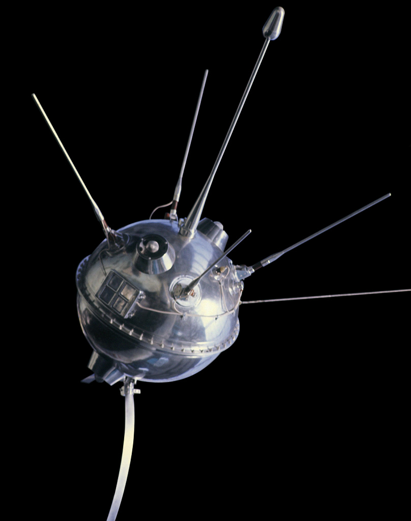
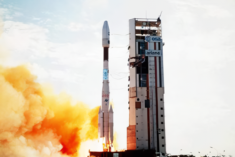
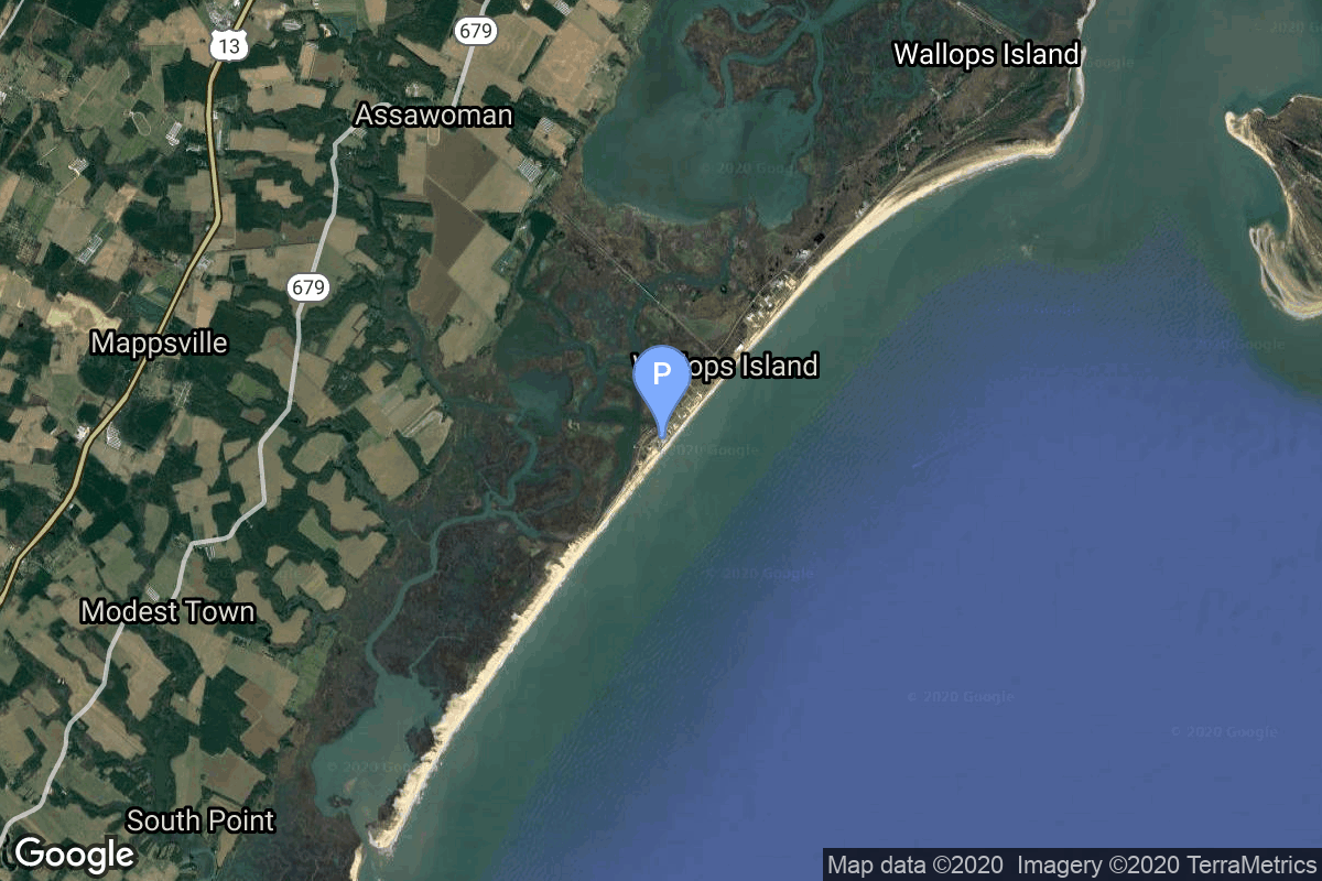
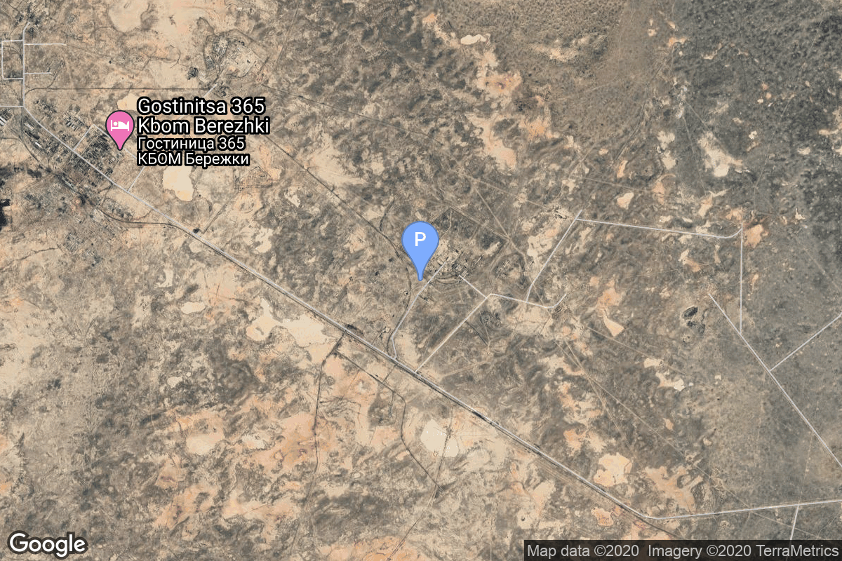
{ "count": 7503, "next": "https://ll.thespacedevs.com/2.0.0/launch/?format=api&limit=10&offset=580&ordering=id", "previous": "https://ll.thespacedevs.com/2.0.0/launch/?format=api&limit=10&offset=560&ordering=id", "results": [ { "id": "13fe0f8f-f242-472b-997f-577dcac87c22", "url": "https://ll.thespacedevs.com/2.0.0/launch/13fe0f8f-f242-472b-997f-577dcac87c22/?format=api", "launch_library_id": null, "slug": "molniya-m-luna-12", "name": "Molniya-M | Luna-12", "status": { "id": 3, "name": "Success" }, "net": "1966-10-22T08:42:26Z", "window_end": "1966-10-22T08:42:26Z", "window_start": "1966-10-22T08:42:26Z", "inhold": false, "tbdtime": false, "tbddate": false, "probability": null, "holdreason": "", "failreason": null, "hashtag": null, "launch_service_provider": { "id": 66, "url": "https://ll.thespacedevs.com/2.0.0/agencies/66/?format=api", "name": "Soviet Space Program", "type": "Government" }, "rocket": { "id": 3583, "configuration": { "id": 106, "launch_library_id": 126, "url": "https://ll.thespacedevs.com/2.0.0/config/launcher/106/?format=api", "name": "Molniya-M", "family": "R-7", "full_name": "Molniya-M 2BL", "variant": "2BL" } }, "mission": { "id": 2002, "launch_library_id": null, "name": "Luna-12", "description": "Lunar probe designed to orbit the Moon", "launch_designator": null, "type": "Lunar Exploration", "orbit": { "id": 11, "name": "Lunar Orbit", "abbrev": "LO" } }, "pad": { "id": 20, "url": "https://ll.thespacedevs.com/2.0.0/pad/20/?format=api", "agency_id": null, "name": "31/6", "info_url": null, "wiki_url": "https://en.wikipedia.org/wiki/Baikonur_Cosmodrome_Site_31", "map_url": "https://www.google.com/maps?q=45.996034,63.564003", "latitude": "45.996034", "longitude": "63.564003", "location": { "id": 15, "url": "https://ll.thespacedevs.com/2.0.0/location/15/?format=api", "name": "Baikonur Cosmodrome, Republic of Kazakhstan", "country_code": "KAZ", "map_image": "https://thespacedevs-prod.nyc3.digitaloceanspaces.com/media/map_images/location_15_20200803142517.jpg", "total_launch_count": 1555, "total_landing_count": 0 }, "map_image": "https://thespacedevs-prod.nyc3.digitaloceanspaces.com/media/map_images/pad_20_20200803143516.jpg", "total_launch_count": 422 }, "webcast_live": false, "image": null, "infographic": null, "program": [ { "id": 38, "url": "https://ll.thespacedevs.com/2.0.0/program/38/?format=api", "name": "Luna", "description": "The Luna program was a series of robotic spacecraft missions sent to the Moon by the Soviet Union between 1959 and 1976. The program accomplished many firsts in space exploration, including first flyby of the Moon, first impact of the Moon and first photos of the far side of the Moon. Each mission was designed as either an orbiter or lander. They also performed many experiments, studying the Moon's chemical composition, gravity, temperature, and radiation.", "agencies": [ { "id": 66, "url": "https://ll.thespacedevs.com/2.0.0/agencies/66/?format=api", "name": "Soviet Space Program", "type": "Government" } ], "image_url": "https://thespacedevs-prod.nyc3.digitaloceanspaces.com/media/images/luna_1_impactor_image_20240813082956.jpg", "start_date": "1958-09-23T07:40:23Z", "end_date": "1976-08-22T17:55:00Z", "info_url": null, "wiki_url": "https://en.wikipedia.org/wiki/Luna_programme" } ] }, { "id": "14014cb5-a328-42f6-b355-d67105be6e17", "url": "https://ll.thespacedevs.com/2.0.0/launch/14014cb5-a328-42f6-b355-d67105be6e17/?format=api", "launch_library_id": null, "slug": "ariane-44lp-telstar-7", "name": "Ariane 44LP | Telstar 7", "status": { "id": 3, "name": "Success" }, "net": "1999-09-25T06:29:00Z", "window_end": "1999-09-25T06:29:00Z", "window_start": "1999-09-25T06:29:00Z", "inhold": false, "tbdtime": false, "tbddate": false, "probability": null, "holdreason": "", "failreason": null, "hashtag": null, "launch_service_provider": { "id": 115, "url": "https://ll.thespacedevs.com/2.0.0/agencies/115/?format=api", "name": "Arianespace", "type": "Commercial" }, "rocket": { "id": 6943, "configuration": { "id": 226, "launch_library_id": null, "url": "https://ll.thespacedevs.com/2.0.0/config/launcher/226/?format=api", "name": "Ariane 44LP", "family": "Ariane", "full_name": "Ariane 44LP", "variant": "44LP" } }, "mission": { "id": 5333, "launch_library_id": null, "name": "Telstar 7", "description": "American communications satellite", "launch_designator": null, "type": "Communications", "orbit": { "id": 1, "name": "Geostationary Orbit", "abbrev": "Direct-GEO" } }, "pad": { "id": 124, "url": "https://ll.thespacedevs.com/2.0.0/pad/124/?format=api", "agency_id": 115, "name": "Ariane Launch Area 2", "info_url": null, "wiki_url": "https://en.wikipedia.org/wiki/ELA-2", "map_url": "https://www.google.com/maps?q=5.232,-52.778194", "latitude": "5.232", "longitude": "-52.778194", "location": { "id": 13, "url": "https://ll.thespacedevs.com/2.0.0/location/13/?format=api", "name": "Guiana Space Centre, French Guiana", "country_code": "GUF", "map_image": "https://thespacedevs-prod.nyc3.digitaloceanspaces.com/media/map_images/location_13_20200803142412.jpg", "total_launch_count": 325, "total_landing_count": 0 }, "map_image": "https://thespacedevs-prod.nyc3.digitaloceanspaces.com/media/map_images/pad_124_20200803143241.jpg", "total_launch_count": 119 }, "webcast_live": false, "image": "https://thespacedevs-prod.nyc3.digitaloceanspaces.com/media/images/ariane_44lp_at__image_20240401083402.png", "infographic": null, "program": [] }, { "id": "140dd3f9-da40-4558-878f-a84246d76151", "url": "https://ll.thespacedevs.com/2.0.0/launch/140dd3f9-da40-4558-878f-a84246d76151/?format=api", "launch_library_id": null, "slug": "electron-6x-hawkeye-360", "name": "Electron | 6x HawkEye 360", "status": { "id": 2, "name": "TBD" }, "net": "2025-06-30T00:00:00Z", "window_end": "2025-06-30T00:00:00Z", "window_start": "2025-06-30T00:00:00Z", "inhold": false, "tbdtime": true, "tbddate": true, "probability": null, "holdreason": "", "failreason": "", "hashtag": null, "launch_service_provider": { "id": 147, "url": "https://ll.thespacedevs.com/2.0.0/agencies/147/?format=api", "name": "Rocket Lab", "type": "Commercial" }, "rocket": { "id": 7566, "configuration": { "id": 26, "launch_library_id": 148, "url": "https://ll.thespacedevs.com/2.0.0/config/launcher/26/?format=api", "name": "Electron", "family": "", "full_name": "Electron", "variant": "" } }, "mission": { "id": 6493, "launch_library_id": null, "name": "6x HawkEye 360", "description": "HawkEye 360 is a a space-based civil global intelligence satellite network using radio frequency (RF) technology to help monitor transportation across air, land and sea and assist with emergencies, and to provide civil SIGINT (Signal Intelligence) mission.\r\n\r\nThe constellation of small satellites (named Hawk ) will collect information on specific radio signals worldwide to provide high-precision radio frequency mapping and analytics from Low Earth orbit (LEO).", "launch_designator": null, "type": "Earth Science", "orbit": { "id": 8, "name": "Low Earth Orbit", "abbrev": "LEO" } }, "pad": { "id": 79, "url": "https://ll.thespacedevs.com/2.0.0/pad/79/?format=api", "agency_id": 147, "name": "Rocket Lab Launch Complex 2 (Launch Area 0 C)", "info_url": null, "wiki_url": null, "map_url": "https://www.google.com/maps?q=37.833262,-75.488235", "latitude": "37.833262", "longitude": "-75.488235", "location": { "id": 21, "url": "https://ll.thespacedevs.com/2.0.0/location/21/?format=api", "name": "Wallops Flight Facility, Virginia, USA", "country_code": "USA", "map_image": "https://thespacedevs-prod.nyc3.digitaloceanspaces.com/media/map_images/location_21_20200803142423.jpg", "total_launch_count": 80, "total_landing_count": 0 }, "map_image": "https://thespacedevs-prod.nyc3.digitaloceanspaces.com/media/map_images/pad_79_20200803143607.jpg", "total_launch_count": 6 }, "webcast_live": false, "image": "https://thespacedevs-prod.nyc3.digitaloceanspaces.com/media/images/electron_image_20190705175640.jpeg", "infographic": null, "program": [] }, { "id": "141120bb-43c9-4645-bf87-b7fe475b03e6", "url": "https://ll.thespacedevs.com/2.0.0/launch/141120bb-43c9-4645-bf87-b7fe475b03e6/?format=api", "launch_library_id": null, "slug": "molniya-m-molniya-1k-48", "name": "Molniya-M | Molniya-1K 48", "status": { "id": 3, "name": "Success" }, "net": "1980-11-16T04:18:00Z", "window_end": "1980-11-16T04:18:00Z", "window_start": "1980-11-16T04:18:00Z", "inhold": false, "tbdtime": false, "tbddate": false, "probability": null, "holdreason": "", "failreason": null, "hashtag": null, "launch_service_provider": { "id": 66, "url": "https://ll.thespacedevs.com/2.0.0/agencies/66/?format=api", "name": "Soviet Space Program", "type": "Government" }, "rocket": { "id": 5221, "configuration": { "id": 106, "launch_library_id": 126, "url": "https://ll.thespacedevs.com/2.0.0/config/launcher/106/?format=api", "name": "Molniya-M", "family": "R-7", "full_name": "Molniya-M 2BL", "variant": "2BL" } }, "mission": { "id": 3631, "launch_library_id": null, "name": "Molniya-1K 48", "description": "Military communications satellite in a highly elliptic orbit", "launch_designator": null, "type": "Government/Top Secret", "orbit": { "id": 0, "name": "Elliptical Orbit", "abbrev": "Elliptical" } }, "pad": { "id": 168, "url": "https://ll.thespacedevs.com/2.0.0/pad/168/?format=api", "agency_id": null, "name": "41/1", "info_url": null, "wiki_url": "https://en.wikipedia.org/wiki/Plesetsk_Cosmodrome", "map_url": "https://www.google.com/maps?q=62.941,40.526806", "latitude": "62.941", "longitude": "40.526806", "location": { "id": 6, "url": "https://ll.thespacedevs.com/2.0.0/location/6/?format=api", "name": "Plesetsk Cosmodrome, Russian Federation", "country_code": "RUS", "map_image": "https://thespacedevs-prod.nyc3.digitaloceanspaces.com/media/map_images/location_6_20200803142434.jpg", "total_launch_count": 1674, "total_landing_count": 0 }, "map_image": "https://thespacedevs-prod.nyc3.digitaloceanspaces.com/media/map_images/pad_168_20200803143446.jpg", "total_launch_count": 310 }, "webcast_live": false, "image": null, "infographic": null, "program": [] }, { "id": "1412ecd5-9641-4303-87ec-ae4164b5957b", "url": "https://ll.thespacedevs.com/2.0.0/launch/1412ecd5-9641-4303-87ec-ae4164b5957b/?format=api", "launch_library_id": null, "slug": "proton-uragan-14-to-16", "name": "Proton | Uragan 14 to 16", "status": { "id": 3, "name": "Success" }, "net": "1986-09-16T11:38:09Z", "window_end": "1986-09-16T11:38:09Z", "window_start": "1986-09-16T11:38:09Z", "inhold": false, "tbdtime": false, "tbddate": false, "probability": null, "holdreason": "", "failreason": null, "hashtag": null, "launch_service_provider": { "id": 66, "url": "https://ll.thespacedevs.com/2.0.0/agencies/66/?format=api", "name": "Soviet Space Program", "type": "Government" }, "rocket": { "id": 5891, "configuration": { "id": 80, "launch_library_id": 99, "url": "https://ll.thespacedevs.com/2.0.0/config/launcher/80/?format=api", "name": "Proton", "family": "Proton / UR-500", "full_name": "Proton K/DM-2", "variant": "K/DM-2" } }, "mission": { "id": 4287, "launch_library_id": null, "name": "Uragan 14 to 16", "description": "GLONASS navigation satellites", "launch_designator": null, "type": "Navigation", "orbit": { "id": 12, "name": "Medium Earth Orbit", "abbrev": "MEO" } }, "pad": { "id": 130, "url": "https://ll.thespacedevs.com/2.0.0/pad/130/?format=api", "agency_id": null, "name": "200/40", "info_url": null, "wiki_url": "https://en.wikipedia.org/wiki/Baikonur_Cosmodrome_Site_200", "map_url": "https://www.google.com/maps?q=46.0336111,63.0266949", "latitude": "46.0336111", "longitude": "63.0266949", "location": { "id": 15, "url": "https://ll.thespacedevs.com/2.0.0/location/15/?format=api", "name": "Baikonur Cosmodrome, Republic of Kazakhstan", "country_code": "KAZ", "map_image": "https://thespacedevs-prod.nyc3.digitaloceanspaces.com/media/map_images/location_15_20200803142517.jpg", "total_launch_count": 1555, "total_landing_count": 0 }, "map_image": "https://thespacedevs-prod.nyc3.digitaloceanspaces.com/media/map_images/pad_130_20200803143249.jpg", "total_launch_count": 64 }, "webcast_live": false, "image": "https://thespacedevs-prod.nyc3.digitaloceanspaces.com/media/images/proton_image_20231231095535.jpg", "infographic": null, "program": [ { "id": 34, "url": "https://ll.thespacedevs.com/2.0.0/program/34/?format=api", "name": "GLONASS", "description": "GLONASS (ГЛОНАСС, IPA: [ɡɫɐˈnas]; Russian: Глобальная навигационная спутниковая система, tr. Global'naya Navigatsionnaya Sputnikovaya Sistema, lit. 'Global Navigation Satellite System') is a Russian satellite navigation system operating as part of a radionavigation-satellite service. It provides an alternative to Global Positioning System (GPS) and is the second navigational system in operation with global coverage and of comparable precision.", "agencies": [ { "id": 63, "url": "https://ll.thespacedevs.com/2.0.0/agencies/63/?format=api", "name": "Russian Federal Space Agency (ROSCOSMOS)", "type": "Government" } ], "image_url": "https://thespacedevs-prod.nyc3.digitaloceanspaces.com/media/images/glonass_program_20240102170258.png", "start_date": "1982-10-12T00:00:00Z", "end_date": null, "info_url": "https://www.glonass-iac.ru/en/", "wiki_url": "https://en.wikipedia.org/wiki/GLONASS" } ] }, { "id": "142d8090-eb8b-4c8e-8965-f75c8ced2bf5", "url": "https://ll.thespacedevs.com/2.0.0/launch/142d8090-eb8b-4c8e-8965-f75c8ced2bf5/?format=api", "launch_library_id": null, "slug": "ariane-42p-satcom-c1-gstar-4", "name": "Ariane 42P | Satcom C1 & GStar 4", "status": { "id": 3, "name": "Success" }, "net": "1990-11-20T23:11:00Z", "window_end": "1990-11-20T23:11:00Z", "window_start": "1990-11-20T23:11:00Z", "inhold": false, "tbdtime": false, "tbddate": false, "probability": null, "holdreason": "", "failreason": null, "hashtag": null, "launch_service_provider": { "id": 115, "url": "https://ll.thespacedevs.com/2.0.0/agencies/115/?format=api", "name": "Arianespace", "type": "Commercial" }, "rocket": { "id": 6324, "configuration": { "id": 224, "launch_library_id": null, "url": "https://ll.thespacedevs.com/2.0.0/config/launcher/224/?format=api", "name": "Ariane 42P", "family": "Ariane", "full_name": "Ariane 42P", "variant": "42P" } }, "mission": { "id": 4714, "launch_library_id": null, "name": "Satcom C1 & GStar 4", "description": "Geostationary communications satellites", "launch_designator": null, "type": "Communications", "orbit": { "id": 1, "name": "Geostationary Orbit", "abbrev": "Direct-GEO" } }, "pad": { "id": 124, "url": "https://ll.thespacedevs.com/2.0.0/pad/124/?format=api", "agency_id": 115, "name": "Ariane Launch Area 2", "info_url": null, "wiki_url": "https://en.wikipedia.org/wiki/ELA-2", "map_url": "https://www.google.com/maps?q=5.232,-52.778194", "latitude": "5.232", "longitude": "-52.778194", "location": { "id": 13, "url": "https://ll.thespacedevs.com/2.0.0/location/13/?format=api", "name": "Guiana Space Centre, French Guiana", "country_code": "GUF", "map_image": "https://thespacedevs-prod.nyc3.digitaloceanspaces.com/media/map_images/location_13_20200803142412.jpg", "total_launch_count": 325, "total_landing_count": 0 }, "map_image": "https://thespacedevs-prod.nyc3.digitaloceanspaces.com/media/map_images/pad_124_20200803143241.jpg", "total_launch_count": 119 }, "webcast_live": false, "image": "https://thespacedevs-prod.nyc3.digitaloceanspaces.com/media/images/ariane42p_at_el_image_20240310184548.png", "infographic": null, "program": [] }, { "id": "14376b98-a668-41e5-ab0d-832babee5366", "url": "https://ll.thespacedevs.com/2.0.0/launch/14376b98-a668-41e5-ab0d-832babee5366/?format=api", "launch_library_id": null, "slug": "long-march-3-dfh-2-1", "name": "Long March 3 | DFH-2 1", "status": { "id": 7, "name": "Partial Failure" }, "net": "1984-01-29T12:25:00Z", "window_end": "1984-01-29T12:25:00Z", "window_start": "1984-01-29T12:25:00Z", "inhold": false, "tbdtime": false, "tbddate": false, "probability": null, "holdreason": "", "failreason": "Due to insufficient pressurization of the third stage during restart, the payload was inserted in a lower-than-planned orbit.", "hashtag": null, "launch_service_provider": { "id": 1036, "url": "https://ll.thespacedevs.com/2.0.0/agencies/1036/?format=api", "name": "Ministry of Space Industry", "type": "Government" }, "rocket": { "id": 5601, "configuration": { "id": 270, "launch_library_id": null, "url": "https://ll.thespacedevs.com/2.0.0/config/launcher/270/?format=api", "name": "Long March 3", "family": "Long March", "full_name": "Long March 3", "variant": "3" } }, "mission": { "id": 4004, "launch_library_id": null, "name": "DFH-2 1", "description": "Chinese geostationary communications satellite", "launch_designator": null, "type": "Communications", "orbit": { "id": 1, "name": "Geostationary Orbit", "abbrev": "Direct-GEO" } }, "pad": { "id": 66, "url": "https://ll.thespacedevs.com/2.0.0/pad/66/?format=api", "agency_id": 17, "name": "Launch Complex 3 (LC-3/LA-1)", "info_url": null, "wiki_url": "https://en.wikipedia.org/wiki/Xichang_Satellite_Launch_Center", "map_url": "https://www.google.com/maps?q=28.247209,102.02917", "latitude": "28.247209", "longitude": "102.02917", "location": { "id": 16, "url": "https://ll.thespacedevs.com/2.0.0/location/16/?format=api", "name": "Xichang Satellite Launch Center, People's Republic of China", "country_code": "CHN", "map_image": "https://thespacedevs-prod.nyc3.digitaloceanspaces.com/media/map_images/location_16_20200803142513.jpg", "total_launch_count": 225, "total_landing_count": 0 }, "map_image": "https://thespacedevs-prod.nyc3.digitaloceanspaces.com/media/map_images/pad_66_20200803143611.jpg", "total_launch_count": 100 }, "webcast_live": false, "image": null, "infographic": null, "program": [] }, { "id": "143904a9-06fb-4bc4-a4ad-2af2049a29d5", "url": "https://ll.thespacedevs.com/2.0.0/launch/143904a9-06fb-4bc4-a4ad-2af2049a29d5/?format=api", "launch_library_id": null, "slug": "proton-kdm-gorizont-3", "name": "Proton-K/DM | Gorizont 3", "status": { "id": 3, "name": "Success" }, "net": "1979-12-28T11:51:00Z", "window_end": "1979-12-28T11:51:00Z", "window_start": "1979-12-28T11:51:00Z", "inhold": false, "tbdtime": false, "tbddate": false, "probability": null, "holdreason": "", "failreason": null, "hashtag": null, "launch_service_provider": { "id": 66, "url": "https://ll.thespacedevs.com/2.0.0/agencies/66/?format=api", "name": "Soviet Space Program", "type": "Government" }, "rocket": { "id": 5135, "configuration": { "id": 349, "launch_library_id": null, "url": "https://ll.thespacedevs.com/2.0.0/config/launcher/349/?format=api", "name": "Proton-K/DM", "family": "Proton / UR-500", "full_name": "Proton-K/DM", "variant": "DM" } }, "mission": { "id": 3546, "launch_library_id": null, "name": "Gorizont 3", "description": "Geostationary communications satellite", "launch_designator": null, "type": "Communications", "orbit": { "id": 1, "name": "Geostationary Orbit", "abbrev": "Direct-GEO" } }, "pad": { "id": 130, "url": "https://ll.thespacedevs.com/2.0.0/pad/130/?format=api", "agency_id": null, "name": "200/40", "info_url": null, "wiki_url": "https://en.wikipedia.org/wiki/Baikonur_Cosmodrome_Site_200", "map_url": "https://www.google.com/maps?q=46.0336111,63.0266949", "latitude": "46.0336111", "longitude": "63.0266949", "location": { "id": 15, "url": "https://ll.thespacedevs.com/2.0.0/location/15/?format=api", "name": "Baikonur Cosmodrome, Republic of Kazakhstan", "country_code": "KAZ", "map_image": "https://thespacedevs-prod.nyc3.digitaloceanspaces.com/media/map_images/location_15_20200803142517.jpg", "total_launch_count": 1555, "total_landing_count": 0 }, "map_image": "https://thespacedevs-prod.nyc3.digitaloceanspaces.com/media/map_images/pad_130_20200803143249.jpg", "total_launch_count": 64 }, "webcast_live": false, "image": "https://thespacedevs-prod.nyc3.digitaloceanspaces.com/media/images/proton_image_20231231095535.jpg", "infographic": null, "program": [] }, { "id": "143b7f89-c64b-44ba-b8f3-f40ba8ad068c", "url": "https://ll.thespacedevs.com/2.0.0/launch/143b7f89-c64b-44ba-b8f3-f40ba8ad068c/?format=api", "launch_library_id": 1261, "slug": "falcon-9-block-5-iridium-7", "name": "Falcon 9 Block 5 | Iridium-7", "status": { "id": 3, "name": "Success" }, "net": "2018-07-25T11:39:30Z", "window_end": "2018-07-25T11:39:30Z", "window_start": "2018-07-25T11:39:30Z", "inhold": false, "tbdtime": false, "tbddate": false, "probability": 90, "holdreason": "", "failreason": "", "hashtag": "#Iridium7", "launch_service_provider": { "id": 121, "url": "https://ll.thespacedevs.com/2.0.0/agencies/121/?format=api", "name": "SpaceX", "type": "Commercial" }, "rocket": { "id": 2119, "configuration": { "id": 164, "launch_library_id": 188, "url": "https://ll.thespacedevs.com/2.0.0/config/launcher/164/?format=api", "name": "Falcon 9", "family": "Falcon", "full_name": "Falcon 9 Block 5", "variant": "Block 5" } }, "mission": { "id": 459, "launch_library_id": 601, "name": "Iridium-7", "description": "SpaceX’s Falcon 9 rocket will deliver 10 satellites to low Earth orbit for Iridium, a global leader in mobile voice and data satellite communications. This is the seventh set of 10 satellites in a series of 75 total satellites that SpaceX will launch for Iridium’s next generation global satellite constellation, Iridium® NEXT.", "launch_designator": null, "type": "Communications", "orbit": { "id": 8, "name": "Low Earth Orbit", "abbrev": "LEO" } }, "pad": { "id": 16, "url": "https://ll.thespacedevs.com/2.0.0/pad/16/?format=api", "agency_id": null, "name": "Space Launch Complex 4E", "info_url": null, "wiki_url": "https://en.wikipedia.org/wiki/Vandenberg_Space_Launch_Complex_4#SLC-4E", "map_url": "https://www.google.com/maps?q=34.632,-120.611", "latitude": "34.632", "longitude": "-120.611", "location": { "id": 11, "url": "https://ll.thespacedevs.com/2.0.0/location/11/?format=api", "name": "Vandenberg SFB, CA, USA", "country_code": "USA", "map_image": "https://thespacedevs-prod.nyc3.digitaloceanspaces.com/media/map_images/location_11_20200803142416.jpg", "total_launch_count": 807, "total_landing_count": 26 }, "map_image": "https://thespacedevs-prod.nyc3.digitaloceanspaces.com/media/map_images/pad_16_20200803143532.jpg", "total_launch_count": 193 }, "webcast_live": false, "image": "https://thespacedevs-prod.nyc3.digitaloceanspaces.com/media/images/falcon_9_image_20230807133459.jpeg", "infographic": null, "program": [ { "id": 28, "url": "https://ll.thespacedevs.com/2.0.0/program/28/?format=api", "name": "Iridium Constellation", "description": "The Iridium satellite constellation provides L band voice and data information coverage to satellite phones, satellite messenger communication devices and integrated transceivers.", "agencies": [ { "id": 202, "url": "https://ll.thespacedevs.com/2.0.0/agencies/202/?format=api", "name": "Iridium Communications", "type": "Commercial" } ], "image_url": "https://thespacedevs-prod.nyc3.digitaloceanspaces.com/media/images/iridium2520con_program_20231228184831.jpeg", "start_date": "1997-05-05T00:00:00Z", "end_date": null, "info_url": "https://iridium.com/", "wiki_url": "https://en.wikipedia.org/wiki/Iridium_satellite_constellation" } ] }, { "id": "143e3967-37ab-4b75-9868-a43eabd7438e", "url": "https://ll.thespacedevs.com/2.0.0/launch/143e3967-37ab-4b75-9868-a43eabd7438e/?format=api", "launch_library_id": null, "slug": "titan-402a-ius-dsp-15", "name": "Titan 402A IUS | DSP 15", "status": { "id": 3, "name": "Success" }, "net": "1990-11-13T00:37:02Z", "window_end": "1990-11-13T00:37:02Z", "window_start": "1990-11-13T00:37:02Z", "inhold": false, "tbdtime": false, "tbddate": false, "probability": null, "holdreason": "", "failreason": null, "hashtag": null, "launch_service_provider": { "id": 161, "url": "https://ll.thespacedevs.com/2.0.0/agencies/161/?format=api", "name": "United States Air Force", "type": "Government" }, "rocket": { "id": 6320, "configuration": { "id": 428, "launch_library_id": null, "url": "https://ll.thespacedevs.com/2.0.0/config/launcher/428/?format=api", "name": "Titan 402A IUS", "family": "Titan", "full_name": "Titan 402A IUS", "variant": "402A IUS" } }, "mission": { "id": 4710, "launch_library_id": null, "name": "DSP 15", "description": "Early warning satellite", "launch_designator": null, "type": "Government/Top Secret", "orbit": { "id": 1, "name": "Geostationary Orbit", "abbrev": "Direct-GEO" } }, "pad": { "id": 29, "url": "https://ll.thespacedevs.com/2.0.0/pad/29/?format=api", "agency_id": null, "name": "Space Launch Complex 41", "info_url": null, "wiki_url": "https://en.wikipedia.org/wiki/Cape_Canaveral_Air_Force_Station_Space_Launch_Complex_41", "map_url": "https://www.google.com/maps?q=28.58341025,-80.58303644", "latitude": "28.58341025", "longitude": "-80.58303644", "location": { "id": 12, "url": "https://ll.thespacedevs.com/2.0.0/location/12/?format=api", "name": "Cape Canaveral SFS, FL, USA", "country_code": "USA", "map_image": "https://thespacedevs-prod.nyc3.digitaloceanspaces.com/media/map_images/location_12_20200803142519.jpg", "total_launch_count": 1023, "total_landing_count": 64 }, "map_image": "https://thespacedevs-prod.nyc3.digitaloceanspaces.com/media/map_images/pad_29_20200803143528.jpg", "total_launch_count": 115 }, "webcast_live": false, "image": null, "infographic": null, "program": [] } ] }