Launch List
API endpoint that returns all Launch objects or a single launch.
EXAMPLE - /launch/
GET: Return a list of all Launch objects.
FILTERS: Fields - 'name', 'id(s)', 'lsp_id', 'lsp_name', 'serial_number', 'launcher_config__id', 'rocket__spacecraftflight__spacecraft__name'
MODE: 'normal', 'list', 'detailed' EXAMPLE: ?mode=list
SEARCH: Searches through the launch name, rocket name, launch agency, mission name & spacecraft name. EXAMPLE - ?search=SpaceX
GET /2.0.0/launch/?format=api&offset=520&ordering=net
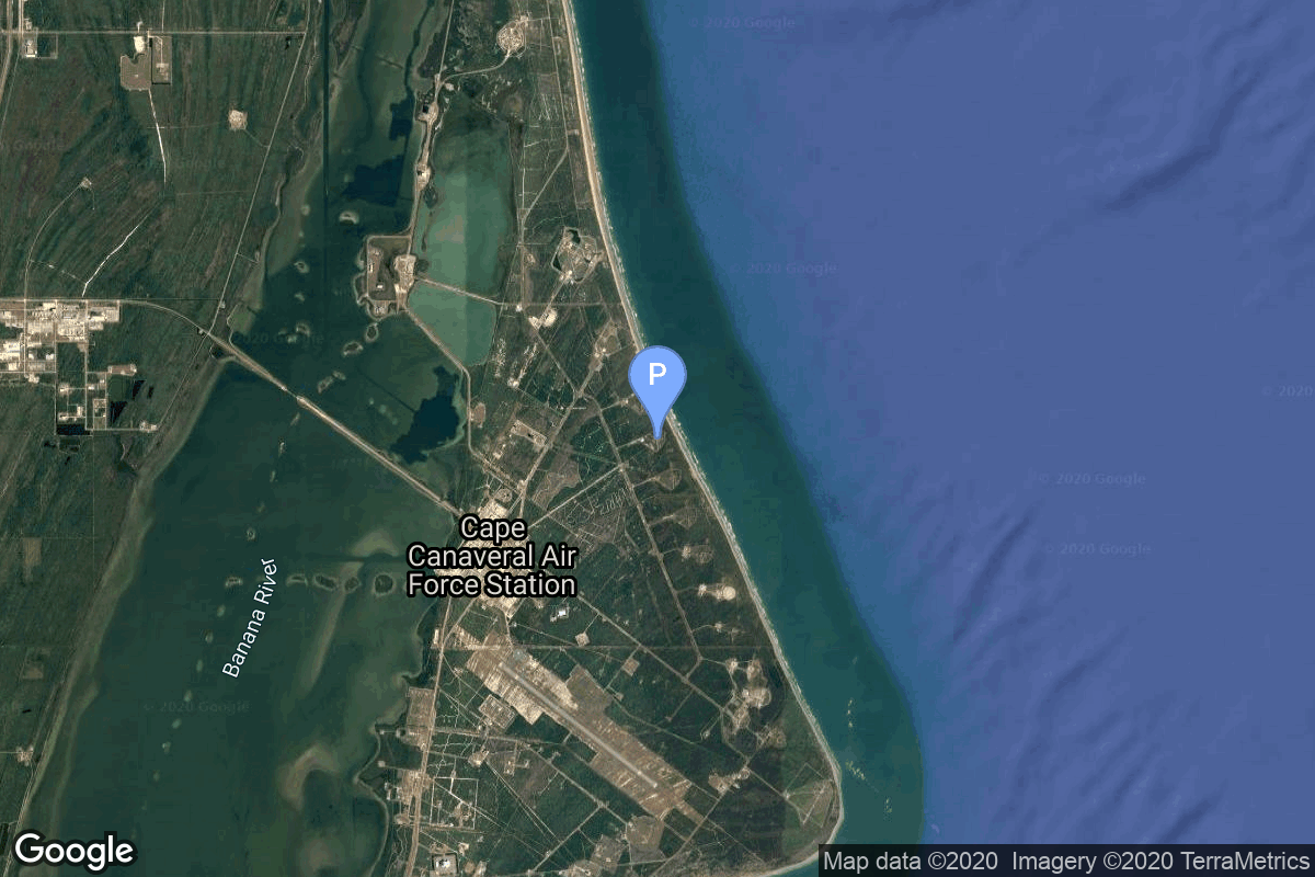
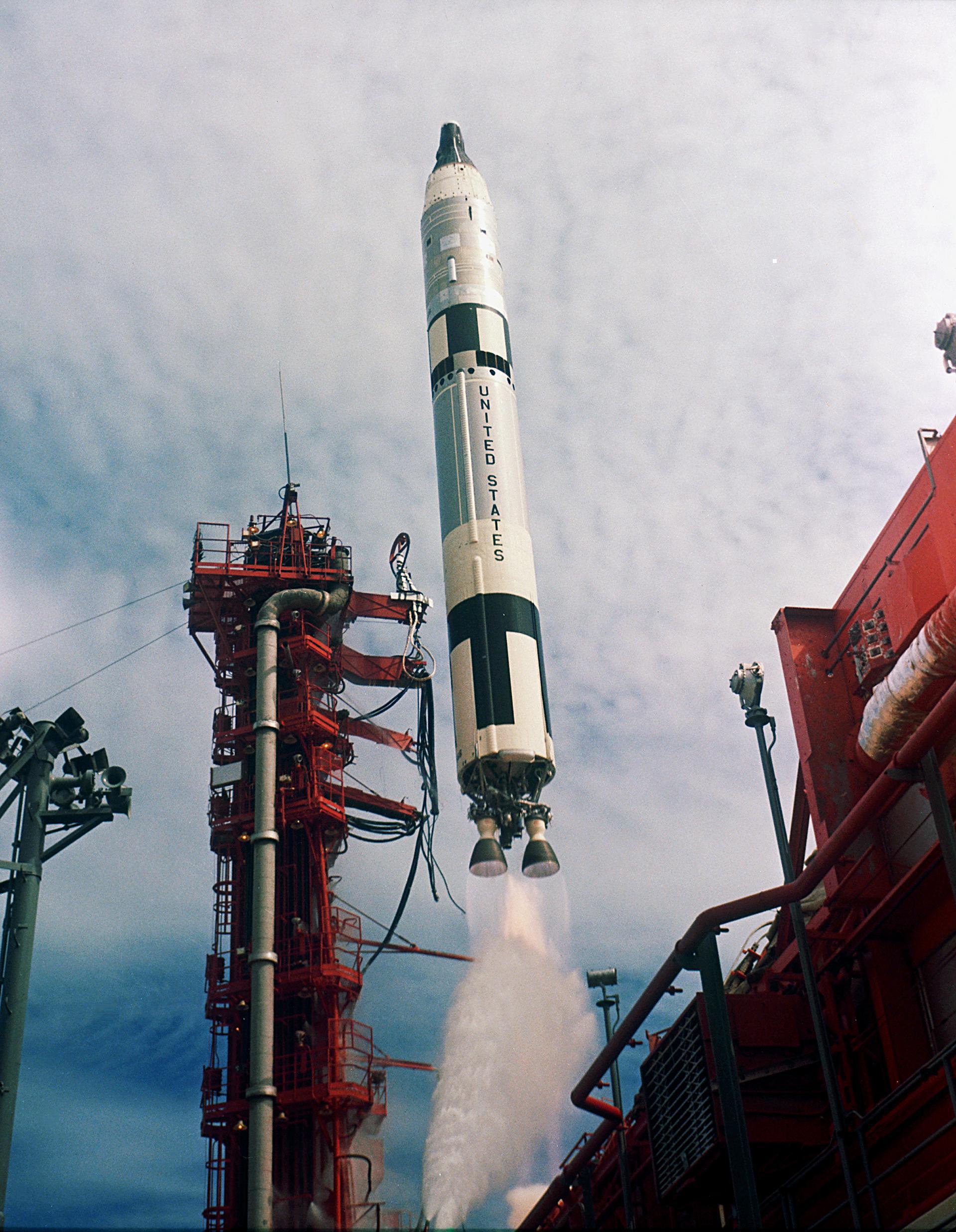
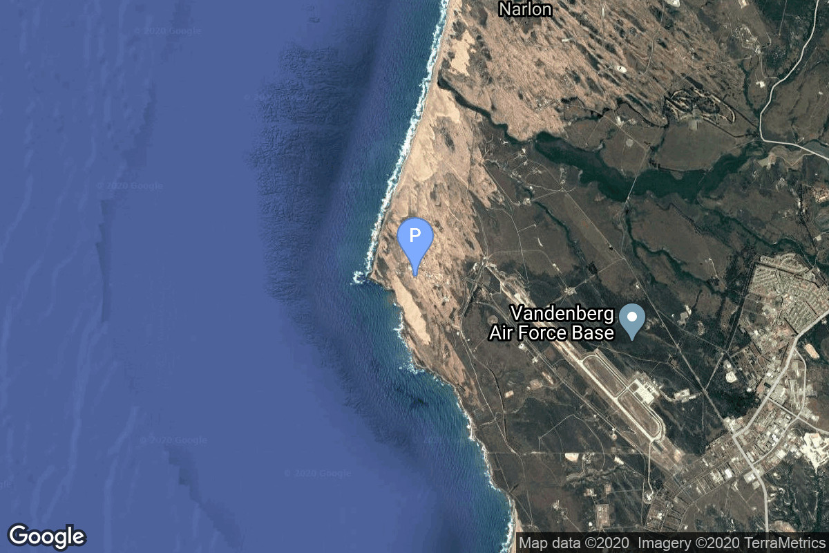
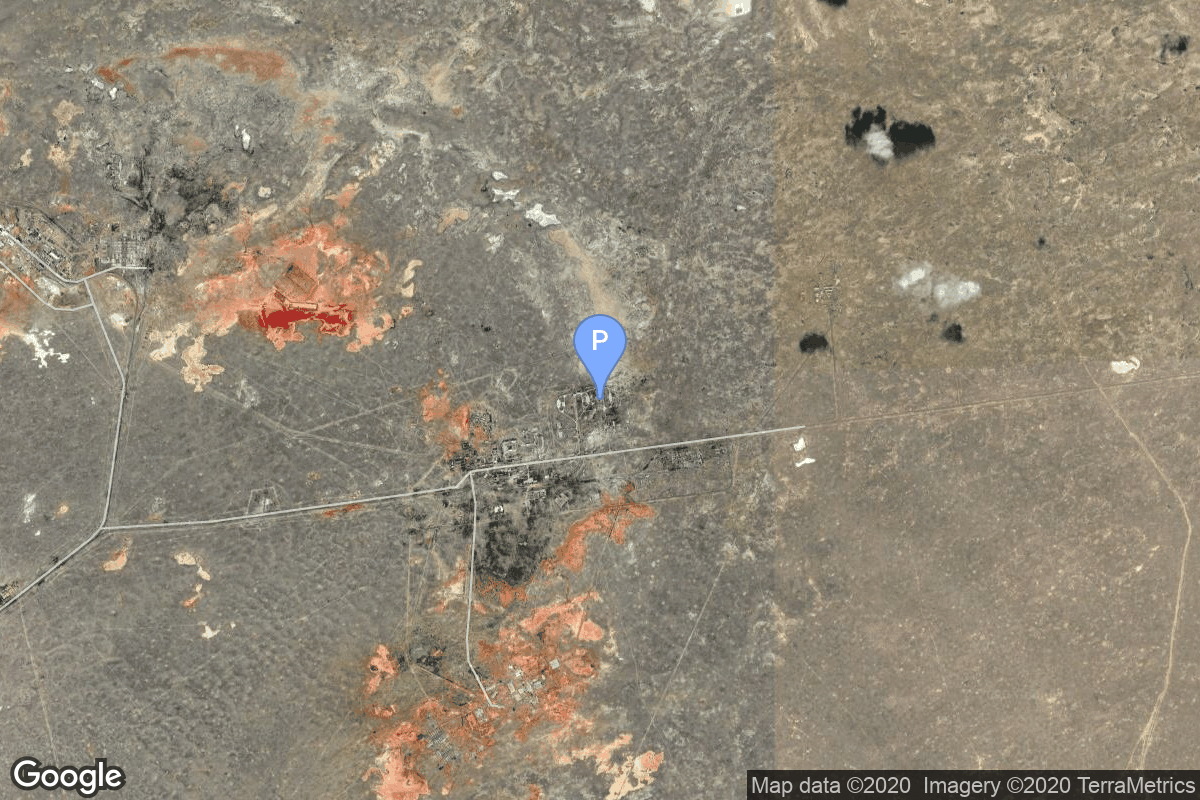
{ "count": 7502, "next": "https://ll.thespacedevs.com/2.0.0/launch/?format=api&limit=10&offset=530&ordering=net", "previous": "https://ll.thespacedevs.com/2.0.0/launch/?format=api&limit=10&offset=510&ordering=net", "results": [ { "id": "91d14e4a-ff12-4a9e-861b-d97ba6196269", "url": "https://ll.thespacedevs.com/2.0.0/launch/91d14e4a-ff12-4a9e-861b-d97ba6196269/?format=api", "launch_library_id": 1014, "slug": "titan-ii-glv-gemini-v", "name": "Titan II GLV | Gemini V", "status": { "id": 3, "name": "Success" }, "net": "1965-08-21T14:00:00Z", "window_end": "1965-08-21T14:00:00Z", "window_start": "1965-08-21T14:00:00Z", "inhold": false, "tbdtime": false, "tbddate": false, "probability": null, "holdreason": "", "failreason": "", "hashtag": null, "launch_service_provider": { "id": 44, "url": "https://ll.thespacedevs.com/2.0.0/agencies/44/?format=api", "name": "National Aeronautics and Space Administration", "type": "Government" }, "rocket": { "id": 203, "configuration": { "id": 98, "launch_library_id": 137, "url": "https://ll.thespacedevs.com/2.0.0/config/launcher/98/?format=api", "name": "Titan II", "family": "Titan", "full_name": "Titan II GLV", "variant": "GLV" } }, "mission": { "id": 266, "launch_library_id": 358, "name": "Gemini V (Gemini 5)", "description": "Gemini 5 was the third crewed mission of the NASA's Project Gemini. The mission was commanded by Command Pilot L. Gordon Cooper, Jr. and Pilot Charles \"Pete\" Conrad, Jr. The mission began on August 21, 1965, 13:59:59 UTC and ended on August 29, 1965, 12:55:13 UTC.", "launch_designator": null, "type": "Human Exploration", "orbit": { "id": 8, "name": "Low Earth Orbit", "abbrev": "LEO" } }, "pad": { "id": 18, "url": "https://ll.thespacedevs.com/2.0.0/pad/18/?format=api", "agency_id": null, "name": "Launch Complex 19", "info_url": null, "wiki_url": "https://en.wikipedia.org/wiki/Cape_Canaveral_Air_Force_Station_Launch_Complex_19", "map_url": "https://www.google.com/maps?q=28.506898,-80.554169", "latitude": "28.506898", "longitude": "-80.554169", "location": { "id": 12, "url": "https://ll.thespacedevs.com/2.0.0/location/12/?format=api", "name": "Cape Canaveral SFS, FL, USA", "country_code": "USA", "map_image": "https://thespacedevs-prod.nyc3.digitaloceanspaces.com/media/map_images/location_12_20200803142519.jpg", "total_launch_count": 1023, "total_landing_count": 64 }, "map_image": "https://thespacedevs-prod.nyc3.digitaloceanspaces.com/media/map_images/pad_18_20200803143356.jpg", "total_launch_count": 12 }, "webcast_live": false, "image": "https://thespacedevs-prod.nyc3.digitaloceanspaces.com/media/images/titan2520ii_image_20190222030027.jpeg", "infographic": null, "program": [ { "id": 3, "url": "https://ll.thespacedevs.com/2.0.0/program/3/?format=api", "name": "Gemini", "description": "Project Gemini was NASA's second human spaceflight program. Conducted between projects Mercury and Apollo, Gemini started in 1961 and concluded in 1966.", "agencies": [ { "id": 44, "url": "https://ll.thespacedevs.com/2.0.0/agencies/44/?format=api", "name": "National Aeronautics and Space Administration", "type": "Government" } ], "image_url": "https://thespacedevs-prod.nyc3.digitaloceanspaces.com/media/images/project2520gem_program_20200820195350.png", "start_date": "1961-12-07T00:00:00Z", "end_date": "1966-11-15T19:21:04Z", "info_url": "https://www.nasa.gov/mission_pages/gemini/index.html", "wiki_url": "https://en.wikipedia.org/wiki/Project_Gemini" } ] }, { "id": "b0719e98-0829-4b9b-b05b-109a7f0d487c", "url": "https://ll.thespacedevs.com/2.0.0/launch/b0719e98-0829-4b9b-b05b-109a7f0d487c/?format=api", "launch_library_id": null, "slug": "voskhod-zenit-4-10", "name": "Voskhod | Zenit-4 10", "status": { "id": 3, "name": "Success" }, "net": "1965-08-25T10:10:02Z", "window_end": "1965-08-25T10:10:02Z", "window_start": "1965-08-25T10:10:02Z", "inhold": false, "tbdtime": false, "tbddate": false, "probability": null, "holdreason": "", "failreason": null, "hashtag": null, "launch_service_provider": { "id": 66, "url": "https://ll.thespacedevs.com/2.0.0/agencies/66/?format=api", "name": "Soviet Space Program", "type": "Government" }, "rocket": { "id": 3430, "configuration": { "id": 104, "launch_library_id": 138, "url": "https://ll.thespacedevs.com/2.0.0/config/launcher/104/?format=api", "name": "Voskhod", "family": "R-7", "full_name": "Voskhod", "variant": "Voskhod" } }, "mission": { "id": 1850, "launch_library_id": null, "name": "Zenit-4 10", "description": "Zenit-4 film-return reconnaissance satellite.", "launch_designator": null, "type": "Government/Top Secret", "orbit": { "id": 8, "name": "Low Earth Orbit", "abbrev": "LEO" } }, "pad": { "id": 32, "url": "https://ll.thespacedevs.com/2.0.0/pad/32/?format=api", "agency_id": null, "name": "1/5", "info_url": null, "wiki_url": "", "map_url": "https://www.google.com/maps?q=45.92,63.342", "latitude": "45.92", "longitude": "63.342", "location": { "id": 15, "url": "https://ll.thespacedevs.com/2.0.0/location/15/?format=api", "name": "Baikonur Cosmodrome, Republic of Kazakhstan", "country_code": "KAZ", "map_image": "https://thespacedevs-prod.nyc3.digitaloceanspaces.com/media/map_images/location_15_20200803142517.jpg", "total_launch_count": 1555, "total_landing_count": 0 }, "map_image": "https://thespacedevs-prod.nyc3.digitaloceanspaces.com/media/map_images/pad_32_20200803143513.jpg", "total_launch_count": 487 }, "webcast_live": false, "image": null, "infographic": null, "program": [] }, { "id": "f70762c1-22f6-45a4-b2e4-a3ca2927ad6f", "url": "https://ll.thespacedevs.com/2.0.0/launch/f70762c1-22f6-45a4-b2e4-a3ca2927ad6f/?format=api", "launch_library_id": null, "slug": "thor-delta-c-oso-c", "name": "Thor Delta C | OSO C", "status": { "id": 4, "name": "Failure" }, "net": "1965-08-25T15:17:00Z", "window_end": "1965-08-25T15:17:00Z", "window_start": "1965-08-25T15:17:00Z", "inhold": false, "tbdtime": false, "tbddate": false, "probability": null, "holdreason": "", "failreason": null, "hashtag": null, "launch_service_provider": { "id": 161, "url": "https://ll.thespacedevs.com/2.0.0/agencies/161/?format=api", "name": "United States Air Force", "type": "Government" }, "rocket": { "id": 3431, "configuration": { "id": 401, "launch_library_id": null, "url": "https://ll.thespacedevs.com/2.0.0/config/launcher/401/?format=api", "name": "Thor Delta C", "family": "Thor", "full_name": "Thor Delta C", "variant": "Delta C" } }, "mission": { "id": 1851, "launch_library_id": null, "name": "OSO C", "description": "OSO (Orbital Solar Observatory) satellite. Its purpose was to return data on the ultraviolet, X-ray and gamma ray emissions of the sun and galaxy.", "launch_designator": null, "type": "Astrophysics", "orbit": { "id": 8, "name": "Low Earth Orbit", "abbrev": "LEO" } }, "pad": { "id": 1, "url": "https://ll.thespacedevs.com/2.0.0/pad/1/?format=api", "agency_id": null, "name": "Space Launch Complex 17B", "info_url": null, "wiki_url": "https://en.wikipedia.org/wiki/Cape_Canaveral_Space_Launch_Complex_17", "map_url": "https://www.google.com/maps?q=28.4458,-80.5657", "latitude": "28.4458", "longitude": "-80.5657", "location": { "id": 12, "url": "https://ll.thespacedevs.com/2.0.0/location/12/?format=api", "name": "Cape Canaveral SFS, FL, USA", "country_code": "USA", "map_image": "https://thespacedevs-prod.nyc3.digitaloceanspaces.com/media/map_images/location_12_20200803142519.jpg", "total_launch_count": 1023, "total_landing_count": 64 }, "map_image": "https://thespacedevs-prod.nyc3.digitaloceanspaces.com/media/map_images/pad_1_20200803143208.jpg", "total_launch_count": 132 }, "webcast_live": false, "image": null, "infographic": null, "program": [] }, { "id": "b02cce52-ea6e-4acc-89f0-f6b98ae682a8", "url": "https://ll.thespacedevs.com/2.0.0/launch/b02cce52-ea6e-4acc-89f0-f6b98ae682a8/?format=api", "launch_library_id": null, "slug": "thor-slv-2-agena-d-mrpv", "name": "Thor SLV-2 Agena D | MRPV", "status": { "id": 4, "name": "Failure" }, "net": "1965-09-02T20:00:16Z", "window_end": "1965-09-02T20:00:16Z", "window_start": "1965-09-02T20:00:16Z", "inhold": false, "tbdtime": false, "tbddate": false, "probability": null, "holdreason": "", "failreason": null, "hashtag": null, "launch_service_provider": { "id": 161, "url": "https://ll.thespacedevs.com/2.0.0/agencies/161/?format=api", "name": "United States Air Force", "type": "Government" }, "rocket": { "id": 3432, "configuration": { "id": 415, "launch_library_id": null, "url": "https://ll.thespacedevs.com/2.0.0/config/launcher/415/?format=api", "name": "Thor SLV-2 Agena D", "family": "Thor", "full_name": "Thor SLV-2 Agena D", "variant": "SLV-2 Agena D" } }, "mission": { "id": 1852, "launch_library_id": null, "name": "MRPV", "description": "MRPV (Multi Research Payload Vehicle) was a satellite which carried 21 experiments for the USAF.", "launch_designator": null, "type": "Earth Science", "orbit": { "id": 8, "name": "Low Earth Orbit", "abbrev": "LEO" } }, "pad": { "id": 96, "url": "https://ll.thespacedevs.com/2.0.0/pad/96/?format=api", "agency_id": 161, "name": "Space Launch Complex 1E", "info_url": null, "wiki_url": "https://en.wikipedia.org/wiki/Vandenberg_Space_Launch_Complex_1", "map_url": "https://www.google.com/maps?q=34.756,-120.6263", "latitude": "34.756", "longitude": "-120.6263", "location": { "id": 11, "url": "https://ll.thespacedevs.com/2.0.0/location/11/?format=api", "name": "Vandenberg SFB, CA, USA", "country_code": "USA", "map_image": "https://thespacedevs-prod.nyc3.digitaloceanspaces.com/media/map_images/location_11_20200803142416.jpg", "total_launch_count": 807, "total_landing_count": 26 }, "map_image": "https://thespacedevs-prod.nyc3.digitaloceanspaces.com/media/map_images/pad_96_20200803143221.jpg", "total_launch_count": 45 }, "webcast_live": false, "image": null, "infographic": null, "program": [] }, { "id": "eae4ad82-ab5a-4ee4-8551-9810ddaca7b6", "url": "https://ll.thespacedevs.com/2.0.0/launch/eae4ad82-ab5a-4ee4-8551-9810ddaca7b6/?format=api", "launch_library_id": null, "slug": "kosmos-65s3-strela-1-20-to-24", "name": "Kosmos 65S3 | Strela-1 20 to 24", "status": { "id": 3, "name": "Success" }, "net": "1965-09-03T14:00:00Z", "window_end": "1965-09-03T14:00:00Z", "window_start": "1965-09-03T14:00:00Z", "inhold": false, "tbdtime": false, "tbddate": false, "probability": null, "holdreason": "", "failreason": null, "hashtag": null, "launch_service_provider": { "id": 66, "url": "https://ll.thespacedevs.com/2.0.0/agencies/66/?format=api", "name": "Soviet Space Program", "type": "Government" }, "rocket": { "id": 3433, "configuration": { "id": 329, "launch_library_id": null, "url": "https://ll.thespacedevs.com/2.0.0/config/launcher/329/?format=api", "name": "Kosmos 65S3", "family": "Kosmos", "full_name": "Kosmos 65S3", "variant": "65S3" } }, "mission": { "id": 1853, "launch_library_id": null, "name": "Strela-1 20 to 24", "description": "The Strela-1 satellites were prototype store-dump communications satellites for tactical communication.", "launch_designator": null, "type": "Government/Top Secret", "orbit": { "id": 8, "name": "Low Earth Orbit", "abbrev": "LEO" } }, "pad": { "id": 164, "url": "https://ll.thespacedevs.com/2.0.0/pad/164/?format=api", "agency_id": null, "name": "41/15", "info_url": null, "wiki_url": "https://en.wikipedia.org/wiki/Baikonur_Cosmodrome", "map_url": "https://www.google.com/maps?q=45.976,63.666806", "latitude": "45.976", "longitude": "63.666806", "location": { "id": 15, "url": "https://ll.thespacedevs.com/2.0.0/location/15/?format=api", "name": "Baikonur Cosmodrome, Republic of Kazakhstan", "country_code": "KAZ", "map_image": "https://thespacedevs-prod.nyc3.digitaloceanspaces.com/media/map_images/location_15_20200803142517.jpg", "total_launch_count": 1555, "total_landing_count": 0 }, "map_image": "https://thespacedevs-prod.nyc3.digitaloceanspaces.com/media/map_images/pad_164_20200803143415.jpg", "total_launch_count": 12 }, "webcast_live": false, "image": null, "infographic": null, "program": [] }, { "id": "4b6eeb90-e140-46db-a32b-66dd446ff032", "url": "https://ll.thespacedevs.com/2.0.0/launch/4b6eeb90-e140-46db-a32b-66dd446ff032/?format=api", "launch_library_id": null, "slug": "voskhod-zenit-4-11", "name": "Voskhod | Zenit-4 11", "status": { "id": 3, "name": "Success" }, "net": "1965-09-09T09:30:00Z", "window_end": "1965-09-09T09:30:00Z", "window_start": "1965-09-09T09:30:00Z", "inhold": false, "tbdtime": false, "tbddate": false, "probability": null, "holdreason": "", "failreason": null, "hashtag": null, "launch_service_provider": { "id": 66, "url": "https://ll.thespacedevs.com/2.0.0/agencies/66/?format=api", "name": "Soviet Space Program", "type": "Government" }, "rocket": { "id": 3434, "configuration": { "id": 104, "launch_library_id": 138, "url": "https://ll.thespacedevs.com/2.0.0/config/launcher/104/?format=api", "name": "Voskhod", "family": "R-7", "full_name": "Voskhod", "variant": "Voskhod" } }, "mission": { "id": 1854, "launch_library_id": null, "name": "Zenit-4 11", "description": "Zenit-4 film-return reconnaissance satellite.", "launch_designator": null, "type": "Government/Top Secret", "orbit": { "id": 8, "name": "Low Earth Orbit", "abbrev": "LEO" } }, "pad": { "id": 20, "url": "https://ll.thespacedevs.com/2.0.0/pad/20/?format=api", "agency_id": null, "name": "31/6", "info_url": null, "wiki_url": "https://en.wikipedia.org/wiki/Baikonur_Cosmodrome_Site_31", "map_url": "https://www.google.com/maps?q=45.996034,63.564003", "latitude": "45.996034", "longitude": "63.564003", "location": { "id": 15, "url": "https://ll.thespacedevs.com/2.0.0/location/15/?format=api", "name": "Baikonur Cosmodrome, Republic of Kazakhstan", "country_code": "KAZ", "map_image": "https://thespacedevs-prod.nyc3.digitaloceanspaces.com/media/map_images/location_15_20200803142517.jpg", "total_launch_count": 1555, "total_landing_count": 0 }, "map_image": "https://thespacedevs-prod.nyc3.digitaloceanspaces.com/media/map_images/pad_20_20200803143516.jpg", "total_launch_count": 422 }, "webcast_live": false, "image": null, "infographic": null, "program": [] }, { "id": "356e8485-1b52-4741-bea8-c7c36f57cff9", "url": "https://ll.thespacedevs.com/2.0.0/launch/356e8485-1b52-4741-bea8-c7c36f57cff9/?format=api", "launch_library_id": null, "slug": "thor-burner-1-dsap-2-f1", "name": "Thor Burner 1 | DSAP-2 F1", "status": { "id": 3, "name": "Success" }, "net": "1965-09-10T04:41:38Z", "window_end": "1965-09-10T04:41:38Z", "window_start": "1965-09-10T04:41:38Z", "inhold": false, "tbdtime": false, "tbddate": false, "probability": null, "holdreason": "", "failreason": null, "hashtag": null, "launch_service_provider": { "id": 161, "url": "https://ll.thespacedevs.com/2.0.0/agencies/161/?format=api", "name": "United States Air Force", "type": "Government" }, "rocket": { "id": 3435, "configuration": { "id": 394, "launch_library_id": null, "url": "https://ll.thespacedevs.com/2.0.0/config/launcher/394/?format=api", "name": "Thor Burner 1", "family": "Thor", "full_name": "Thor Burner 1", "variant": "Burner 1" } }, "mission": { "id": 1855, "launch_library_id": null, "name": "DSAP-2 F1", "description": "The DSAP-2 (Defense Satellite Application Program Block 2) satellites series consisted of three modified DSAP-1 military meteorological satellites.", "launch_designator": null, "type": "Government/Top Secret", "orbit": { "id": 17, "name": "Sun-Synchronous Orbit", "abbrev": "SSO" } }, "pad": { "id": 171, "url": "https://ll.thespacedevs.com/2.0.0/pad/171/?format=api", "agency_id": null, "name": "Space Launch Complex 10W", "info_url": null, "wiki_url": "https://en.wikipedia.org/wiki/Vandenberg_Air_Force_Base_Space_Launch_Complex_10", "map_url": "https://www.google.com/maps?q=34.7652778,-120.6244162", "latitude": "34.7652778", "longitude": "-120.6244162", "location": { "id": 11, "url": "https://ll.thespacedevs.com/2.0.0/location/11/?format=api", "name": "Vandenberg SFB, CA, USA", "country_code": "USA", "map_image": "https://thespacedevs-prod.nyc3.digitaloceanspaces.com/media/map_images/location_11_20200803142416.jpg", "total_launch_count": 807, "total_landing_count": 26 }, "map_image": "https://thespacedevs-prod.nyc3.digitaloceanspaces.com/media/map_images/pad_171_20200803143449.jpg", "total_launch_count": 31 }, "webcast_live": false, "image": null, "infographic": null, "program": [] }, { "id": "9fea66d8-120f-4084-8fbd-24aee90032d6", "url": "https://ll.thespacedevs.com/2.0.0/launch/9fea66d8-120f-4084-8fbd-24aee90032d6/?format=api", "launch_library_id": null, "slug": "kosmos-65s3-strela-1-25-to-29", "name": "Kosmos 65S3 | Strela-1 25 to 29", "status": { "id": 3, "name": "Success" }, "net": "1965-09-18T07:59:00Z", "window_end": "1965-09-18T07:59:00Z", "window_start": "1965-09-18T07:59:00Z", "inhold": false, "tbdtime": false, "tbddate": false, "probability": null, "holdreason": "", "failreason": null, "hashtag": null, "launch_service_provider": { "id": 66, "url": "https://ll.thespacedevs.com/2.0.0/agencies/66/?format=api", "name": "Soviet Space Program", "type": "Government" }, "rocket": { "id": 3436, "configuration": { "id": 329, "launch_library_id": null, "url": "https://ll.thespacedevs.com/2.0.0/config/launcher/329/?format=api", "name": "Kosmos 65S3", "family": "Kosmos", "full_name": "Kosmos 65S3", "variant": "65S3" } }, "mission": { "id": 1856, "launch_library_id": null, "name": "Strela-1 25 to 29", "description": "The Strela-1 satellites were prototype store-dump communications satellites for tactical communication.", "launch_designator": null, "type": "Government/Top Secret", "orbit": { "id": 8, "name": "Low Earth Orbit", "abbrev": "LEO" } }, "pad": { "id": 164, "url": "https://ll.thespacedevs.com/2.0.0/pad/164/?format=api", "agency_id": null, "name": "41/15", "info_url": null, "wiki_url": "https://en.wikipedia.org/wiki/Baikonur_Cosmodrome", "map_url": "https://www.google.com/maps?q=45.976,63.666806", "latitude": "45.976", "longitude": "63.666806", "location": { "id": 15, "url": "https://ll.thespacedevs.com/2.0.0/location/15/?format=api", "name": "Baikonur Cosmodrome, Republic of Kazakhstan", "country_code": "KAZ", "map_image": "https://thespacedevs-prod.nyc3.digitaloceanspaces.com/media/map_images/location_15_20200803142517.jpg", "total_launch_count": 1555, "total_landing_count": 0 }, "map_image": "https://thespacedevs-prod.nyc3.digitaloceanspaces.com/media/map_images/pad_164_20200803143415.jpg", "total_launch_count": 12 }, "webcast_live": false, "image": null, "infographic": null, "program": [] }, { "id": "8f103e72-2d7d-4847-9435-3e36a3f2505d", "url": "https://ll.thespacedevs.com/2.0.0/launch/8f103e72-2d7d-4847-9435-3e36a3f2505d/?format=api", "launch_library_id": null, "slug": "thor-slv-2a-agena-d-kh-4a-24", "name": "Thor SLV-2A Agena D | KH-4A 24", "status": { "id": 3, "name": "Success" }, "net": "1965-09-22T21:31:14Z", "window_end": "1965-09-22T21:31:14Z", "window_start": "1965-09-22T21:31:14Z", "inhold": false, "tbdtime": false, "tbddate": false, "probability": null, "holdreason": "", "failreason": null, "hashtag": null, "launch_service_provider": { "id": 161, "url": "https://ll.thespacedevs.com/2.0.0/agencies/161/?format=api", "name": "United States Air Force", "type": "Government" }, "rocket": { "id": 3437, "configuration": { "id": 417, "launch_library_id": null, "url": "https://ll.thespacedevs.com/2.0.0/config/launcher/417/?format=api", "name": "Thor SLV-2A Agena D", "family": "Thor", "full_name": "Thor SLV-2A Agena D", "variant": "SLV-2A Agena D" } }, "mission": { "id": 1857, "launch_library_id": null, "name": "KH-4A 24", "description": "The KH-4A (Keyhole-4A) was the fifth optical reconnaissance satellite version in the Corona-program.", "launch_designator": null, "type": "Government/Top Secret", "orbit": { "id": 8, "name": "Low Earth Orbit", "abbrev": "LEO" } }, "pad": { "id": 93, "url": "https://ll.thespacedevs.com/2.0.0/pad/93/?format=api", "agency_id": 161, "name": "Space Launch Complex 3W", "info_url": null, "wiki_url": "https://en.wikipedia.org/wiki/Vandenberg_Space_Launch_Complex_3#SLC-3W", "map_url": "https://www.google.com/maps?q=34.644,-120.593", "latitude": "34.644", "longitude": "-120.593", "location": { "id": 11, "url": "https://ll.thespacedevs.com/2.0.0/location/11/?format=api", "name": "Vandenberg SFB, CA, USA", "country_code": "USA", "map_image": "https://thespacedevs-prod.nyc3.digitaloceanspaces.com/media/map_images/location_11_20200803142416.jpg", "total_launch_count": 807, "total_landing_count": 26 }, "map_image": "https://thespacedevs-prod.nyc3.digitaloceanspaces.com/media/map_images/pad_93_20200803143225.jpg", "total_launch_count": 81 }, "webcast_live": false, "image": null, "infographic": null, "program": [] }, { "id": "dd4cbac5-31f5-41d0-980c-b1144cfadbb6", "url": "https://ll.thespacedevs.com/2.0.0/launch/dd4cbac5-31f5-41d0-980c-b1144cfadbb6/?format=api", "launch_library_id": null, "slug": "voskhod-zenit-4-12", "name": "Voskhod | Zenit-4 12", "status": { "id": 3, "name": "Success" }, "net": "1965-09-23T09:00:00Z", "window_end": "1965-09-23T09:00:00Z", "window_start": "1965-09-23T09:00:00Z", "inhold": false, "tbdtime": false, "tbddate": false, "probability": null, "holdreason": "", "failreason": null, "hashtag": null, "launch_service_provider": { "id": 66, "url": "https://ll.thespacedevs.com/2.0.0/agencies/66/?format=api", "name": "Soviet Space Program", "type": "Government" }, "rocket": { "id": 3438, "configuration": { "id": 104, "launch_library_id": 138, "url": "https://ll.thespacedevs.com/2.0.0/config/launcher/104/?format=api", "name": "Voskhod", "family": "R-7", "full_name": "Voskhod", "variant": "Voskhod" } }, "mission": { "id": 1858, "launch_library_id": null, "name": "Zenit-4 12", "description": "Zenit-4 film-return reconnaissance satellite.", "launch_designator": null, "type": "Government/Top Secret", "orbit": { "id": 8, "name": "Low Earth Orbit", "abbrev": "LEO" } }, "pad": { "id": 20, "url": "https://ll.thespacedevs.com/2.0.0/pad/20/?format=api", "agency_id": null, "name": "31/6", "info_url": null, "wiki_url": "https://en.wikipedia.org/wiki/Baikonur_Cosmodrome_Site_31", "map_url": "https://www.google.com/maps?q=45.996034,63.564003", "latitude": "45.996034", "longitude": "63.564003", "location": { "id": 15, "url": "https://ll.thespacedevs.com/2.0.0/location/15/?format=api", "name": "Baikonur Cosmodrome, Republic of Kazakhstan", "country_code": "KAZ", "map_image": "https://thespacedevs-prod.nyc3.digitaloceanspaces.com/media/map_images/location_15_20200803142517.jpg", "total_launch_count": 1555, "total_landing_count": 0 }, "map_image": "https://thespacedevs-prod.nyc3.digitaloceanspaces.com/media/map_images/pad_20_20200803143516.jpg", "total_launch_count": 422 }, "webcast_live": false, "image": null, "infographic": null, "program": [] } ] }