Launch List
API endpoint that returns all Launch objects or a single launch.
EXAMPLE - /launch/
GET: Return a list of all Launch objects.
FILTERS: Fields - 'name', 'id(s)', 'lsp_id', 'lsp_name', 'serial_number', 'launcher_config__id', 'rocket__spacecraftflight__spacecraft__name'
MODE: 'normal', 'list', 'detailed' EXAMPLE: ?mode=list
SEARCH: Searches through the launch name, rocket name, launch agency, mission name & spacecraft name. EXAMPLE - ?search=SpaceX
GET /2.0.0/launch/?format=api&offset=380&ordering=-id
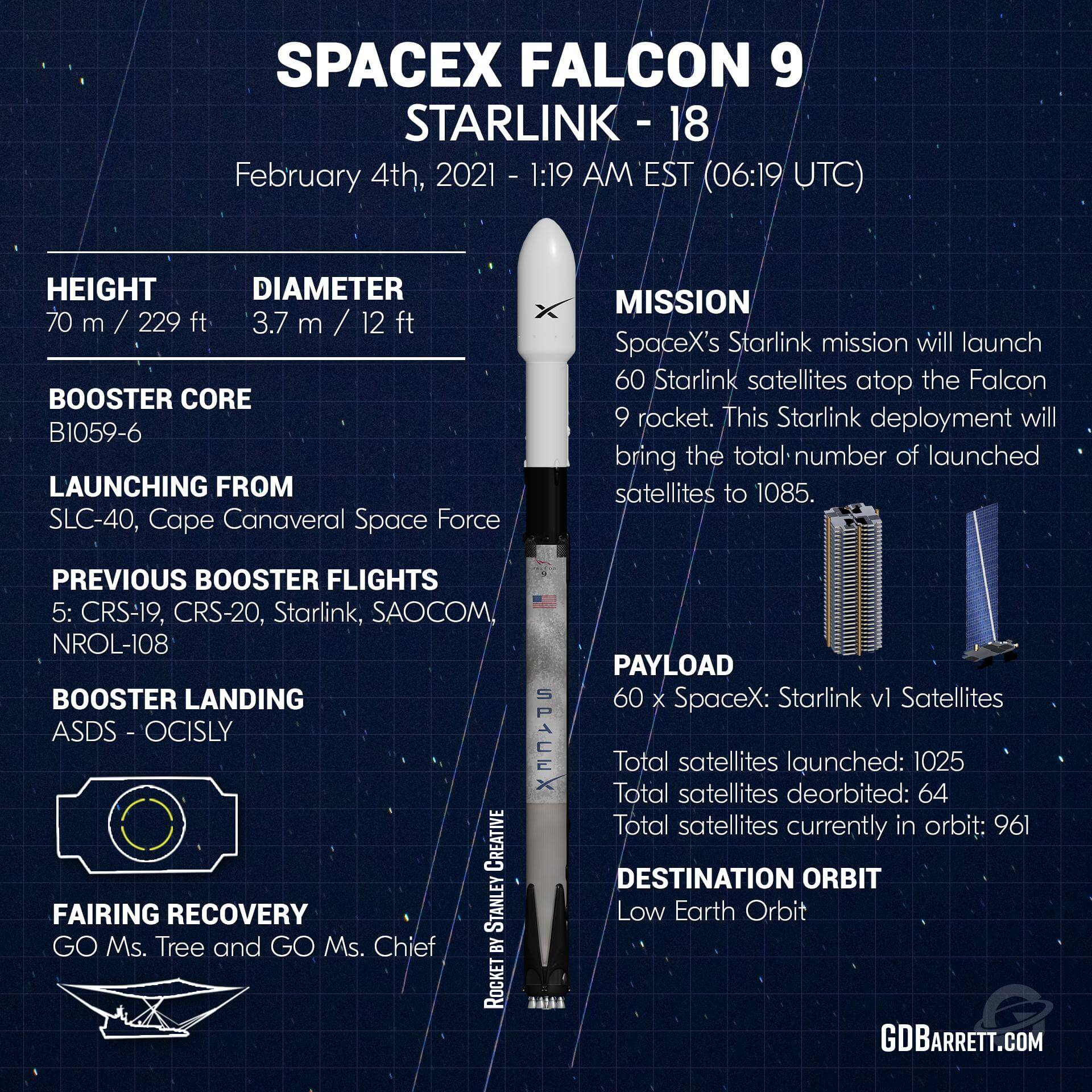
{ "count": 7865, "next": "https://ll.thespacedevs.com/2.0.0/launch/?format=api&limit=10&offset=390&ordering=-id", "previous": "https://ll.thespacedevs.com/2.0.0/launch/?format=api&limit=10&offset=370&ordering=-id", "results": [ { "id": "f31702e8-6353-4c9a-932c-5bd104717500", "url": "https://ll.thespacedevs.com/2.0.0/launch/f31702e8-6353-4c9a-932c-5bd104717500/?format=api", "launch_library_id": null, "slug": "falcon-9-block-5-starlink-18", "name": "Falcon 9 Block 5 | Starlink 18", "status": { "id": 3, "name": "Success" }, "net": "2021-02-04T06:19:54Z", "window_end": "2021-02-04T06:19:54Z", "window_start": "2021-02-04T06:19:54Z", "inhold": false, "tbdtime": false, "tbddate": false, "probability": 95, "holdreason": "", "failreason": "", "hashtag": null, "launch_service_provider": { "id": 121, "url": "https://ll.thespacedevs.com/2.0.0/agencies/121/?format=api", "name": "SpaceX", "type": "Commercial" }, "rocket": { "id": 2822, "configuration": { "id": 164, "launch_library_id": 188, "url": "https://ll.thespacedevs.com/2.0.0/config/launcher/164/?format=api", "name": "Falcon 9", "family": "Falcon", "full_name": "Falcon 9 Block 5", "variant": "Block 5" } }, "mission": { "id": 1230, "launch_library_id": null, "name": "Starlink 18", "description": "A batch of 60 satellites for Starlink mega-constellation - SpaceX's project for space-based Internet communication system.", "launch_designator": null, "type": "Communications", "orbit": { "id": 8, "name": "Low Earth Orbit", "abbrev": "LEO" } }, "pad": { "id": 80, "url": "https://ll.thespacedevs.com/2.0.0/pad/80/?format=api", "agency_id": 121, "name": "Space Launch Complex 40", "info_url": null, "wiki_url": "https://en.wikipedia.org/wiki/Cape_Canaveral_Air_Force_Station_Space_Launch_Complex_40", "map_url": "https://www.google.com/maps?q=28.56194122,-80.57735736", "latitude": "28.56194122", "longitude": "-80.57735736", "location": { "id": 12, "url": "https://ll.thespacedevs.com/2.0.0/location/12/?format=api", "name": "Cape Canaveral SFS, FL, USA", "country_code": "USA", "map_image": "https://thespacedevs-prod.nyc3.digitaloceanspaces.com/media/map_images/location_12_20200803142519.jpg", "total_launch_count": 1108, "total_landing_count": 75 }, "map_image": "https://thespacedevs-prod.nyc3.digitaloceanspaces.com/media/map_images/pad_80_20200803143323.jpg", "total_launch_count": 382 }, "webcast_live": false, "image": "https://thespacedevs-prod.nyc3.digitaloceanspaces.com/media/images/falcon2520925_image_20221009234147.png", "infographic": "https://thespacedevs-prod.nyc3.digitaloceanspaces.com/media/infographic_images/falcon2520925_infographic_20210203034428.jpeg", "program": [ { "id": 25, "url": "https://ll.thespacedevs.com/2.0.0/program/25/?format=api", "name": "Starlink", "description": "Starlink is a satellite internet constellation operated by American aerospace company SpaceX", "agencies": [ { "id": 121, "url": "https://ll.thespacedevs.com/2.0.0/agencies/121/?format=api", "name": "SpaceX", "type": "Commercial" } ], "image_url": "https://thespacedevs-prod.nyc3.digitaloceanspaces.com/media/images/starlink_program_20231228154508.jpeg", "start_date": "2018-02-22T14:17:00Z", "end_date": null, "info_url": "https://starlink.com", "wiki_url": "https://en.wikipedia.org/wiki/Starlink" } ] }, { "id": "f31158bc-1a89-4a72-b521-627d6e5ab5b8", "url": "https://ll.thespacedevs.com/2.0.0/launch/f31158bc-1a89-4a72-b521-627d6e5ab5b8/?format=api", "launch_library_id": null, "slug": "delta-ii-gps-iia-2", "name": "Delta II | GPS IIA-2", "status": { "id": 3, "name": "Success" }, "net": "1991-07-04T02:32:00Z", "window_end": "1991-07-04T02:32:00Z", "window_start": "1991-07-04T02:32:00Z", "inhold": false, "tbdtime": false, "tbddate": false, "probability": null, "holdreason": "", "failreason": "", "hashtag": null, "launch_service_provider": { "id": 161, "url": "https://ll.thespacedevs.com/2.0.0/agencies/161/?format=api", "name": "United States Air Force", "type": "Government" }, "rocket": { "id": 6380, "configuration": { "id": 159, "launch_library_id": 179, "url": "https://ll.thespacedevs.com/2.0.0/config/launcher/159/?format=api", "name": "Delta II", "family": "Delta", "full_name": "Delta II 7925", "variant": "7925" } }, "mission": { "id": 4770, "launch_library_id": null, "name": "GPS IIA-2", "description": "GPS-2A (Global Positioning System) or Navstar-2A (Navigation System using Timing And ranging) are improved satellites of the second generation of the GPS navigation system.", "launch_designator": null, "type": "Navigation", "orbit": { "id": 12, "name": "Medium Earth Orbit", "abbrev": "MEO" } }, "pad": { "id": 14, "url": "https://ll.thespacedevs.com/2.0.0/pad/14/?format=api", "agency_id": null, "name": "Space Launch Complex 17A", "info_url": null, "wiki_url": "https://en.wikipedia.org/wiki/Cape_Canaveral_Space_Launch_Complex_17", "map_url": "https://www.google.com/maps?q=28.4472,-80.565", "latitude": "28.4472", "longitude": "-80.565", "location": { "id": 12, "url": "https://ll.thespacedevs.com/2.0.0/location/12/?format=api", "name": "Cape Canaveral SFS, FL, USA", "country_code": "USA", "map_image": "https://thespacedevs-prod.nyc3.digitaloceanspaces.com/media/map_images/location_12_20200803142519.jpg", "total_launch_count": 1108, "total_landing_count": 75 }, "map_image": "https://thespacedevs-prod.nyc3.digitaloceanspaces.com/media/map_images/pad_14_20200803143451.jpg", "total_launch_count": 145 }, "webcast_live": false, "image": "https://thespacedevs-prod.nyc3.digitaloceanspaces.com/media/images/delta2520ii_image_20190222030440.jpeg", "infographic": null, "program": [ { "id": 29, "url": "https://ll.thespacedevs.com/2.0.0/program/29/?format=api", "name": "Global Positioning System", "description": "The Global Positioning System (GPS), originally Navstar GPS, is a satellite-based radio navigation system owned by the United States government and operated by the United States Space Force. It is one of the global navigation satellite systems (GNSS) that provide geolocation and time information to a GPS receiver anywhere on or near the Earth where there is an unobstructed line of sight to four or more GPS satellites.", "agencies": [ { "id": 1041, "url": "https://ll.thespacedevs.com/2.0.0/agencies/1041/?format=api", "name": "United States Space Force", "type": "Government" } ], "image_url": "https://thespacedevs-prod.nyc3.digitaloceanspaces.com/media/images/global2520posi_program_20231229182501.png", "start_date": "1978-02-22T00:00:00Z", "end_date": null, "info_url": "https://www.gps.gov/", "wiki_url": "https://en.wikipedia.org/wiki/Global_Positioning_System" } ] }, { "id": "f3110d03-7f40-4991-8694-9c09efc66b7e", "url": "https://ll.thespacedevs.com/2.0.0/launch/f3110d03-7f40-4991-8694-9c09efc66b7e/?format=api", "launch_library_id": null, "slug": "tsiklon-2-us-p-36", "name": "Tsiklon-2 | US-P 36", "status": { "id": 3, "name": "Success" }, "net": "1990-12-04T00:48:31Z", "window_end": "1990-12-04T00:48:31Z", "window_start": "1990-12-04T00:48:31Z", "inhold": false, "tbdtime": false, "tbddate": false, "probability": null, "holdreason": "", "failreason": null, "hashtag": null, "launch_service_provider": { "id": 66, "url": "https://ll.thespacedevs.com/2.0.0/agencies/66/?format=api", "name": "Soviet Space Program", "type": "Government" }, "rocket": { "id": 6330, "configuration": { "id": 443, "launch_library_id": null, "url": "https://ll.thespacedevs.com/2.0.0/config/launcher/443/?format=api", "name": "Tsiklon-2", "family": "Tsiklon", "full_name": "Tsiklon-2", "variant": "2" } }, "mission": { "id": 4720, "launch_library_id": null, "name": "US-P 36", "description": "Ocean surveillance satellite using passive ELINT devices", "launch_designator": null, "type": "Government/Top Secret", "orbit": { "id": 8, "name": "Low Earth Orbit", "abbrev": "LEO" } }, "pad": { "id": 132, "url": "https://ll.thespacedevs.com/2.0.0/pad/132/?format=api", "agency_id": null, "name": "90", "info_url": null, "wiki_url": "https://en.wikipedia.org/wiki/Baikonur_Cosmodrome_Site_90", "map_url": "https://www.google.com/maps?q=46.081,62.929806", "latitude": "46.081", "longitude": "62.929806", "location": { "id": 15, "url": "https://ll.thespacedevs.com/2.0.0/location/15/?format=api", "name": "Baikonur Cosmodrome, Republic of Kazakhstan", "country_code": "KAZ", "map_image": "https://thespacedevs-prod.nyc3.digitaloceanspaces.com/media/map_images/location_15_20200803142517.jpg", "total_launch_count": 1563, "total_landing_count": 0 }, "map_image": "https://thespacedevs-prod.nyc3.digitaloceanspaces.com/media/map_images/pad_132_20200803143344.jpg", "total_launch_count": 74 }, "webcast_live": false, "image": "https://thespacedevs-prod.nyc3.digitaloceanspaces.com/media/images/tsyklon-2_lifto_image_20240411113159.jpg", "infographic": null, "program": [] }, { "id": "f30ee6a1-010b-4352-a5d8-0774945c2d01", "url": "https://ll.thespacedevs.com/2.0.0/launch/f30ee6a1-010b-4352-a5d8-0774945c2d01/?format=api", "launch_library_id": null, "slug": "atlas-burner-2-radcat", "name": "Atlas Burner 2 | Radcat", "status": { "id": 3, "name": "Success" }, "net": "1972-10-02T20:10:00Z", "window_end": "1972-10-02T20:10:00Z", "window_start": "1972-10-02T20:10:00Z", "inhold": false, "tbdtime": false, "tbddate": false, "probability": null, "holdreason": "", "failreason": null, "hashtag": null, "launch_service_provider": { "id": 161, "url": "https://ll.thespacedevs.com/2.0.0/agencies/161/?format=api", "name": "United States Air Force", "type": "Government" }, "rocket": { "id": 4298, "configuration": { "id": 234, "launch_library_id": null, "url": "https://ll.thespacedevs.com/2.0.0/config/launcher/234/?format=api", "name": "Atlas Burner 2", "family": "Atlas", "full_name": "Atlas SLV-3 Burner-2", "variant": "Burner-2" } }, "mission": { "id": 2716, "launch_library_id": null, "name": "Radcat", "description": "Cylindrical satellite used to calibrate optical and radar ground equipment.", "launch_designator": null, "type": "Test Target", "orbit": { "id": 8, "name": "Low Earth Orbit", "abbrev": "LEO" } }, "pad": { "id": 173, "url": "https://ll.thespacedevs.com/2.0.0/pad/173/?format=api", "agency_id": null, "name": "576A1", "info_url": null, "wiki_url": "https://en.wikipedia.org/wiki/Vandenberg_Air_Force_Base_Launch_Complex_576", "map_url": "https://www.google.com/maps?q=34.7394444,-120.6213607", "latitude": "34.7394444", "longitude": "-120.6213607", "location": { "id": 11, "url": "https://ll.thespacedevs.com/2.0.0/location/11/?format=api", "name": "Vandenberg SFB, CA, USA", "country_code": "USA", "map_image": "https://thespacedevs-prod.nyc3.digitaloceanspaces.com/media/map_images/location_11_20200803142416.jpg", "total_launch_count": 884, "total_landing_count": 34 }, "map_image": "https://thespacedevs-prod.nyc3.digitaloceanspaces.com/media/map_images/pad_173_20200803143418.jpg", "total_launch_count": 1 }, "webcast_live": false, "image": null, "infographic": null, "program": [] }, { "id": "f3057c20-40b0-437b-9ee4-759a13baa22e", "url": "https://ll.thespacedevs.com/2.0.0/launch/f3057c20-40b0-437b-9ee4-759a13baa22e/?format=api", "launch_library_id": 564, "slug": "rokot-briz-km-gonets-m-14-gonets-m-16-gonets-m-17", "name": "Rokot / Briz-KM | Gonets M-14, Gonets M-16, Gonets M-17", "status": { "id": 3, "name": "Success" }, "net": "2013-09-11T23:23:04Z", "window_end": "2013-09-11T23:23:04Z", "window_start": "2013-09-11T23:23:04Z", "inhold": false, "tbdtime": false, "tbddate": false, "probability": null, "holdreason": "", "failreason": null, "hashtag": null, "launch_service_provider": { "id": 163, "url": "https://ll.thespacedevs.com/2.0.0/agencies/163/?format=api", "name": "Russian Aerospace Defence Forces", "type": "Government" }, "rocket": { "id": 1700, "configuration": { "id": 40, "launch_library_id": 50, "url": "https://ll.thespacedevs.com/2.0.0/config/launcher/40/?format=api", "name": "Rokot/Briz-KM", "family": "Rokot", "full_name": "Rokot/Briz-KM", "variant": "Briz-KM" } }, "mission": { "id": 241, "launch_library_id": 333, "name": "Gonets M-14, Gonets M-16, Gonets M-17", "description": "Gonets-M are an upgraded version of Gonets satellites, derived from military communications system Strela-3. Gonets-M constellation is tasked with monitoring ecological and industrial objects, providing communication and data transmission services, covering also the remote areas like the Far North region.", "launch_designator": null, "type": "Communications", "orbit": { "id": 8, "name": "Low Earth Orbit", "abbrev": "LEO" } }, "pad": { "id": 3, "url": "https://ll.thespacedevs.com/2.0.0/pad/3/?format=api", "agency_id": 163, "name": "133/3 (133L)", "info_url": null, "wiki_url": "", "map_url": "https://www.google.com/maps?q=62.886999,40.846984", "latitude": "62.886999", "longitude": "40.846984", "location": { "id": 6, "url": "https://ll.thespacedevs.com/2.0.0/location/6/?format=api", "name": "Plesetsk Cosmodrome, Russian Federation", "country_code": "RUS", "map_image": "https://thespacedevs-prod.nyc3.digitaloceanspaces.com/media/map_images/location_6_20200803142434.jpg", "total_launch_count": 1685, "total_landing_count": 0 }, "map_image": "https://thespacedevs-prod.nyc3.digitaloceanspaces.com/media/map_images/pad_3_20200803143438.jpg", "total_launch_count": 159 }, "webcast_live": false, "image": "https://thespacedevs-prod.nyc3.digitaloceanspaces.com/media/images/rokot25202f2520briz-km_image_20190224012237.jpeg", "infographic": null, "program": [] }, { "id": "f3022ba4-b981-414d-b61d-ea175594436c", "url": "https://ll.thespacedevs.com/2.0.0/launch/f3022ba4-b981-414d-b61d-ea175594436c/?format=api", "launch_library_id": 1742, "slug": "soyuz-u2-progress-m-2", "name": "Soyuz-U2 | Progress M-2", "status": { "id": 3, "name": "Success" }, "net": "1989-12-20T03:30:50Z", "window_end": "1989-12-20T03:30:50Z", "window_start": "1989-12-20T03:30:50Z", "inhold": false, "tbdtime": false, "tbddate": false, "probability": 0, "holdreason": "", "failreason": "", "hashtag": "", "launch_service_provider": { "id": 66, "url": "https://ll.thespacedevs.com/2.0.0/agencies/66/?format=api", "name": "Soviet Space Program", "type": "Government" }, "rocket": { "id": 2274, "configuration": { "id": 101, "launch_library_id": 133, "url": "https://ll.thespacedevs.com/2.0.0/config/launcher/101/?format=api", "name": "Soyuz-U", "family": "", "full_name": "Soyuz-U2", "variant": "2" } }, "mission": null, "pad": { "id": 32, "url": "https://ll.thespacedevs.com/2.0.0/pad/32/?format=api", "agency_id": null, "name": "1/5", "info_url": null, "wiki_url": "", "map_url": "https://www.google.com/maps?q=45.92,63.342", "latitude": "45.92", "longitude": "63.342", "location": { "id": 15, "url": "https://ll.thespacedevs.com/2.0.0/location/15/?format=api", "name": "Baikonur Cosmodrome, Republic of Kazakhstan", "country_code": "KAZ", "map_image": "https://thespacedevs-prod.nyc3.digitaloceanspaces.com/media/map_images/location_15_20200803142517.jpg", "total_launch_count": 1563, "total_landing_count": 0 }, "map_image": "https://thespacedevs-prod.nyc3.digitaloceanspaces.com/media/map_images/pad_32_20200803143513.jpg", "total_launch_count": 487 }, "webcast_live": false, "image": "https://thespacedevs-prod.nyc3.digitaloceanspaces.com/media/images/soyuz-u_image_20191229074852.jpg", "infographic": null, "program": [ { "id": 16, "url": "https://ll.thespacedevs.com/2.0.0/program/16/?format=api", "name": "Mir", "description": "Mir was a space station that operated in low Earth orbit from 1986 to 2001, operated by the Soviet Union and later by Russia. Mir was the first modular space station and was assembled in orbit from 1986 to 1996.", "agencies": [ { "id": 63, "url": "https://ll.thespacedevs.com/2.0.0/agencies/63/?format=api", "name": "Russian Federal Space Agency (ROSCOSMOS)", "type": "Government" }, { "id": 66, "url": "https://ll.thespacedevs.com/2.0.0/agencies/66/?format=api", "name": "Soviet Space Program", "type": "Government" } ], "image_url": "https://thespacedevs-prod.nyc3.digitaloceanspaces.com/media/images/mir_program_20200821092345.jpeg", "start_date": "1986-02-20T21:28:23Z", "end_date": "2001-03-23T05:59:00Z", "info_url": null, "wiki_url": "https://en.wikipedia.org/wiki/Mir" } ] }, { "id": "f2f7a10f-4c1d-4d90-9734-091399d4797a", "url": "https://ll.thespacedevs.com/2.0.0/launch/f2f7a10f-4c1d-4d90-9734-091399d4797a/?format=api", "launch_library_id": 918, "slug": "soyuz-u2-soyuz-tm-19", "name": "Soyuz-U2 | Soyuz TM-19", "status": { "id": 3, "name": "Success" }, "net": "1994-07-01T12:24:50Z", "window_end": "1994-07-01T12:24:50Z", "window_start": "1994-07-01T12:24:50Z", "inhold": false, "tbdtime": false, "tbddate": false, "probability": null, "holdreason": "", "failreason": null, "hashtag": null, "launch_service_provider": { "id": 63, "url": "https://ll.thespacedevs.com/2.0.0/agencies/63/?format=api", "name": "Russian Federal Space Agency (ROSCOSMOS)", "type": "Government" }, "rocket": { "id": 378, "configuration": { "id": 101, "launch_library_id": 133, "url": "https://ll.thespacedevs.com/2.0.0/config/launcher/101/?format=api", "name": "Soyuz-U", "family": "", "full_name": "Soyuz-U2", "variant": "2" } }, "mission": { "id": 361, "launch_library_id": 471, "name": "Soyuz TM-19", "description": "Soyuz TM-19 was the 19th mission and the 16th long-duration expedition to Mir space station. The mission began on July 1, 1994, 12:24:50 UTC, launching Commander Yuri Malenchenko and Flight Engineer Talgat Musabayev into orbit. They docked with Mir two days later. During their stay there, cosmonauts performed two EVAs, carried out various scientific experiments in medicine, material sciences, astrophysics etc. Station crew was visited by several Progress resupply spacecrafts, and welcomed aboard the Soyuz TM-20 crew.\nThe mission concluded with a safe landing back on Earth on November 4, 1994, 11:18:26 UTC.", "launch_designator": null, "type": "Human Exploration", "orbit": { "id": 8, "name": "Low Earth Orbit", "abbrev": "LEO" } }, "pad": { "id": 32, "url": "https://ll.thespacedevs.com/2.0.0/pad/32/?format=api", "agency_id": null, "name": "1/5", "info_url": null, "wiki_url": "", "map_url": "https://www.google.com/maps?q=45.92,63.342", "latitude": "45.92", "longitude": "63.342", "location": { "id": 15, "url": "https://ll.thespacedevs.com/2.0.0/location/15/?format=api", "name": "Baikonur Cosmodrome, Republic of Kazakhstan", "country_code": "KAZ", "map_image": "https://thespacedevs-prod.nyc3.digitaloceanspaces.com/media/map_images/location_15_20200803142517.jpg", "total_launch_count": 1563, "total_landing_count": 0 }, "map_image": "https://thespacedevs-prod.nyc3.digitaloceanspaces.com/media/map_images/pad_32_20200803143513.jpg", "total_launch_count": 487 }, "webcast_live": false, "image": "https://thespacedevs-prod.nyc3.digitaloceanspaces.com/media/images/soyuz-u_image_20191229074852.jpg", "infographic": null, "program": [ { "id": 8, "url": "https://ll.thespacedevs.com/2.0.0/program/8/?format=api", "name": "Soyuz", "description": "The Soyuz programme is a human spaceflight programme initiated by the Soviet Union in the early 1960s. The Soyuz spacecraft was originally part of a Moon landing project intended to put a Soviet cosmonaut on the Moon. It was the third Soviet human spaceflight programme after the Vostok and Voskhod programmes.", "agencies": [ { "id": 63, "url": "https://ll.thespacedevs.com/2.0.0/agencies/63/?format=api", "name": "Russian Federal Space Agency (ROSCOSMOS)", "type": "Government" }, { "id": 66, "url": "https://ll.thespacedevs.com/2.0.0/agencies/66/?format=api", "name": "Soviet Space Program", "type": "Government" } ], "image_url": "https://thespacedevs-prod.nyc3.digitaloceanspaces.com/media/images/soyuz_program_20201129185543.png", "start_date": "1966-11-28T11:02:00Z", "end_date": null, "info_url": null, "wiki_url": "https://en.wikipedia.org/wiki/Soyuz_programme" }, { "id": 16, "url": "https://ll.thespacedevs.com/2.0.0/program/16/?format=api", "name": "Mir", "description": "Mir was a space station that operated in low Earth orbit from 1986 to 2001, operated by the Soviet Union and later by Russia. Mir was the first modular space station and was assembled in orbit from 1986 to 1996.", "agencies": [ { "id": 63, "url": "https://ll.thespacedevs.com/2.0.0/agencies/63/?format=api", "name": "Russian Federal Space Agency (ROSCOSMOS)", "type": "Government" }, { "id": 66, "url": "https://ll.thespacedevs.com/2.0.0/agencies/66/?format=api", "name": "Soviet Space Program", "type": "Government" } ], "image_url": "https://thespacedevs-prod.nyc3.digitaloceanspaces.com/media/images/mir_program_20200821092345.jpeg", "start_date": "1986-02-20T21:28:23Z", "end_date": "2001-03-23T05:59:00Z", "info_url": null, "wiki_url": "https://en.wikipedia.org/wiki/Mir" } ] }, { "id": "f2e861e9-f956-4bad-8318-3d669ba5aedb", "url": "https://ll.thespacedevs.com/2.0.0/launch/f2e861e9-f956-4bad-8318-3d669ba5aedb/?format=api", "launch_library_id": null, "slug": "falcon-9-block-5-starlink-group-9-13", "name": "Falcon 9 Block 5 | Starlink Group 9-13", "status": { "id": 3, "name": "Success" }, "net": "2024-11-24T05:25:30Z", "window_end": "2024-11-24T07:26:00Z", "window_start": "2024-11-24T03:26:00Z", "inhold": false, "tbdtime": false, "tbddate": false, "probability": null, "holdreason": "", "failreason": "", "hashtag": null, "launch_service_provider": { "id": 121, "url": "https://ll.thespacedevs.com/2.0.0/agencies/121/?format=api", "name": "SpaceX", "type": "Commercial" }, "rocket": { "id": 8367, "configuration": { "id": 164, "launch_library_id": 188, "url": "https://ll.thespacedevs.com/2.0.0/config/launcher/164/?format=api", "name": "Falcon 9", "family": "Falcon", "full_name": "Falcon 9 Block 5", "variant": "Block 5" } }, "mission": { "id": 6948, "launch_library_id": null, "name": "Starlink Group 9-13", "description": "A batch of 20 satellites for the Starlink mega-constellation - SpaceX's project for space-based Internet communication system.", "launch_designator": null, "type": "Communications", "orbit": { "id": 8, "name": "Low Earth Orbit", "abbrev": "LEO" } }, "pad": { "id": 16, "url": "https://ll.thespacedevs.com/2.0.0/pad/16/?format=api", "agency_id": null, "name": "Space Launch Complex 4E", "info_url": null, "wiki_url": "https://en.wikipedia.org/wiki/Vandenberg_Space_Launch_Complex_4#SLC-4E", "map_url": "https://www.google.com/maps?q=34.632,-120.611", "latitude": "34.632", "longitude": "-120.611", "location": { "id": 11, "url": "https://ll.thespacedevs.com/2.0.0/location/11/?format=api", "name": "Vandenberg SFB, CA, USA", "country_code": "USA", "map_image": "https://thespacedevs-prod.nyc3.digitaloceanspaces.com/media/map_images/location_11_20200803142416.jpg", "total_launch_count": 884, "total_landing_count": 34 }, "map_image": "https://thespacedevs-prod.nyc3.digitaloceanspaces.com/media/map_images/pad_16_20200803143532.jpg", "total_launch_count": 268 }, "webcast_live": false, "image": "https://thespacedevs-prod.nyc3.digitaloceanspaces.com/media/images/falcon2520925_image_20221009234147.png", "infographic": null, "program": [ { "id": 25, "url": "https://ll.thespacedevs.com/2.0.0/program/25/?format=api", "name": "Starlink", "description": "Starlink is a satellite internet constellation operated by American aerospace company SpaceX", "agencies": [ { "id": 121, "url": "https://ll.thespacedevs.com/2.0.0/agencies/121/?format=api", "name": "SpaceX", "type": "Commercial" } ], "image_url": "https://thespacedevs-prod.nyc3.digitaloceanspaces.com/media/images/starlink_program_20231228154508.jpeg", "start_date": "2018-02-22T14:17:00Z", "end_date": null, "info_url": "https://starlink.com", "wiki_url": "https://en.wikipedia.org/wiki/Starlink" } ] }, { "id": "f2e04394-e56b-4268-8d04-83833320f8a5", "url": "https://ll.thespacedevs.com/2.0.0/launch/f2e04394-e56b-4268-8d04-83833320f8a5/?format=api", "launch_library_id": null, "slug": "soyuz-u-yantar-4k2-34", "name": "Soyuz U | Yantar-4K2 34", "status": { "id": 3, "name": "Success" }, "net": "1987-10-22T14:24:57Z", "window_end": "1987-10-22T14:24:57Z", "window_start": "1987-10-22T14:24:57Z", "inhold": false, "tbdtime": false, "tbddate": false, "probability": null, "holdreason": "", "failreason": null, "hashtag": null, "launch_service_provider": { "id": 66, "url": "https://ll.thespacedevs.com/2.0.0/agencies/66/?format=api", "name": "Soviet Space Program", "type": "Government" }, "rocket": { "id": 6010, "configuration": { "id": 37, "launch_library_id": 35, "url": "https://ll.thespacedevs.com/2.0.0/config/launcher/37/?format=api", "name": "Soyuz U", "family": "Soyuz", "full_name": "Soyuz U", "variant": "" } }, "mission": { "id": 4401, "launch_library_id": null, "name": "Yantar-4K2 34", "description": "Film-return reconnaissance satellite", "launch_designator": null, "type": "Government/Top Secret", "orbit": { "id": 8, "name": "Low Earth Orbit", "abbrev": "LEO" } }, "pad": { "id": 35, "url": "https://ll.thespacedevs.com/2.0.0/pad/35/?format=api", "agency_id": 163, "name": "16/2", "info_url": null, "wiki_url": "", "map_url": "https://www.google.com/maps?q=62.960091,40.682983", "latitude": "62.960091", "longitude": "40.682983", "location": { "id": 6, "url": "https://ll.thespacedevs.com/2.0.0/location/6/?format=api", "name": "Plesetsk Cosmodrome, Russian Federation", "country_code": "RUS", "map_image": "https://thespacedevs-prod.nyc3.digitaloceanspaces.com/media/map_images/location_6_20200803142434.jpg", "total_launch_count": 1685, "total_landing_count": 0 }, "map_image": "https://thespacedevs-prod.nyc3.digitaloceanspaces.com/media/map_images/pad_35_20200803143306.jpg", "total_launch_count": 136 }, "webcast_live": false, "image": "https://thespacedevs-prod.nyc3.digitaloceanspaces.com/media/images/soyuz2520u_image_20190222031023.jpeg", "infographic": null, "program": [] }, { "id": "f2dab94f-92dc-4304-b6fd-abd86f0aac8c", "url": "https://ll.thespacedevs.com/2.0.0/launch/f2dab94f-92dc-4304-b6fd-abd86f0aac8c/?format=api", "launch_library_id": null, "slug": "proton-m-briz-m-astra-1m", "name": "Proton-M Briz-M | Astra 1M", "status": { "id": 3, "name": "Success" }, "net": "2008-11-05T20:44:20Z", "window_end": "2008-11-05T20:44:20Z", "window_start": "2008-11-05T20:44:20Z", "inhold": false, "tbdtime": false, "tbddate": false, "probability": null, "holdreason": "", "failreason": "", "hashtag": null, "launch_service_provider": { "id": 96, "url": "https://ll.thespacedevs.com/2.0.0/agencies/96/?format=api", "name": "Khrunichev State Research and Production Space Center", "type": "Government" }, "rocket": { "id": 7372, "configuration": { "id": 22, "launch_library_id": 4, "url": "https://ll.thespacedevs.com/2.0.0/config/launcher/22/?format=api", "name": "Proton-M Briz-M", "family": "Proton / UR-500", "full_name": "Proton-M Briz-M", "variant": "Briz-M" } }, "mission": { "id": 5761, "launch_library_id": null, "name": "Astra 1M", "description": "Luxembourgian geostationary direct broadcasting satellite", "launch_designator": null, "type": "Communications", "orbit": { "id": 1, "name": "Geostationary Orbit", "abbrev": "Direct-GEO" } }, "pad": { "id": 15, "url": "https://ll.thespacedevs.com/2.0.0/pad/15/?format=api", "agency_id": null, "name": "200/39 (200L)", "info_url": null, "wiki_url": "", "map_url": "https://www.google.com/maps?q=46.039984,63.032093", "latitude": "46.039984", "longitude": "63.032093", "location": { "id": 15, "url": "https://ll.thespacedevs.com/2.0.0/location/15/?format=api", "name": "Baikonur Cosmodrome, Republic of Kazakhstan", "country_code": "KAZ", "map_image": "https://thespacedevs-prod.nyc3.digitaloceanspaces.com/media/map_images/location_15_20200803142517.jpg", "total_launch_count": 1563, "total_landing_count": 0 }, "map_image": "https://thespacedevs-prod.nyc3.digitaloceanspaces.com/media/map_images/pad_15_20200803143530.jpg", "total_launch_count": 167 }, "webcast_live": false, "image": "https://thespacedevs-prod.nyc3.digitaloceanspaces.com/media/images/proton-m2520briz-m_image_20190224012317.jpeg", "infographic": null, "program": [] } ] }