Launch List
API endpoint that returns all Launch objects or a single launch.
EXAMPLE - /launch/
GET: Return a list of all Launch objects.
FILTERS: Fields - 'name', 'id(s)', 'lsp_id', 'lsp_name', 'serial_number', 'launcher_config__id', 'rocket__spacecraftflight__spacecraft__name'
MODE: 'normal', 'list', 'detailed' EXAMPLE: ?mode=list
SEARCH: Searches through the launch name, rocket name, launch agency, mission name & spacecraft name. EXAMPLE - ?search=SpaceX
GET /2.0.0/launch/?format=api&offset=290&ordering=-id
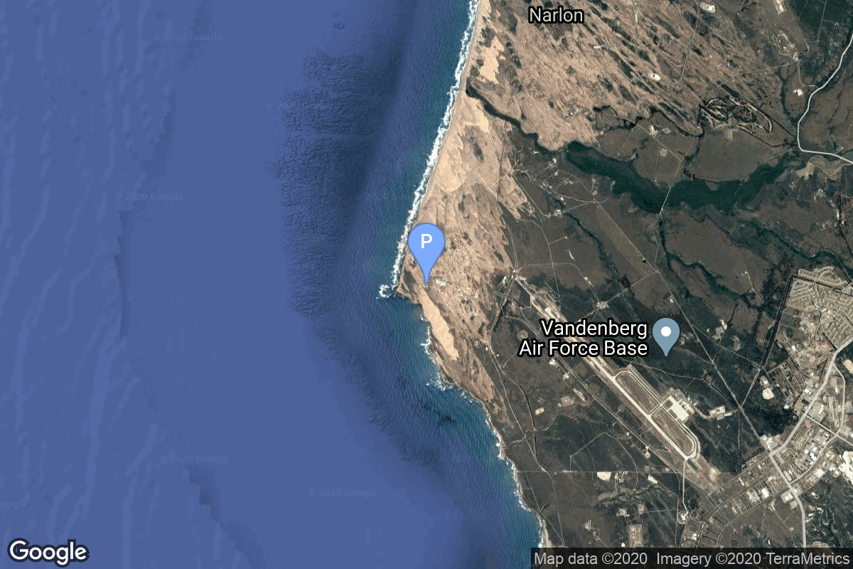
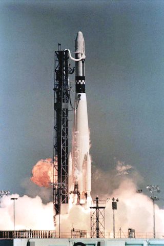
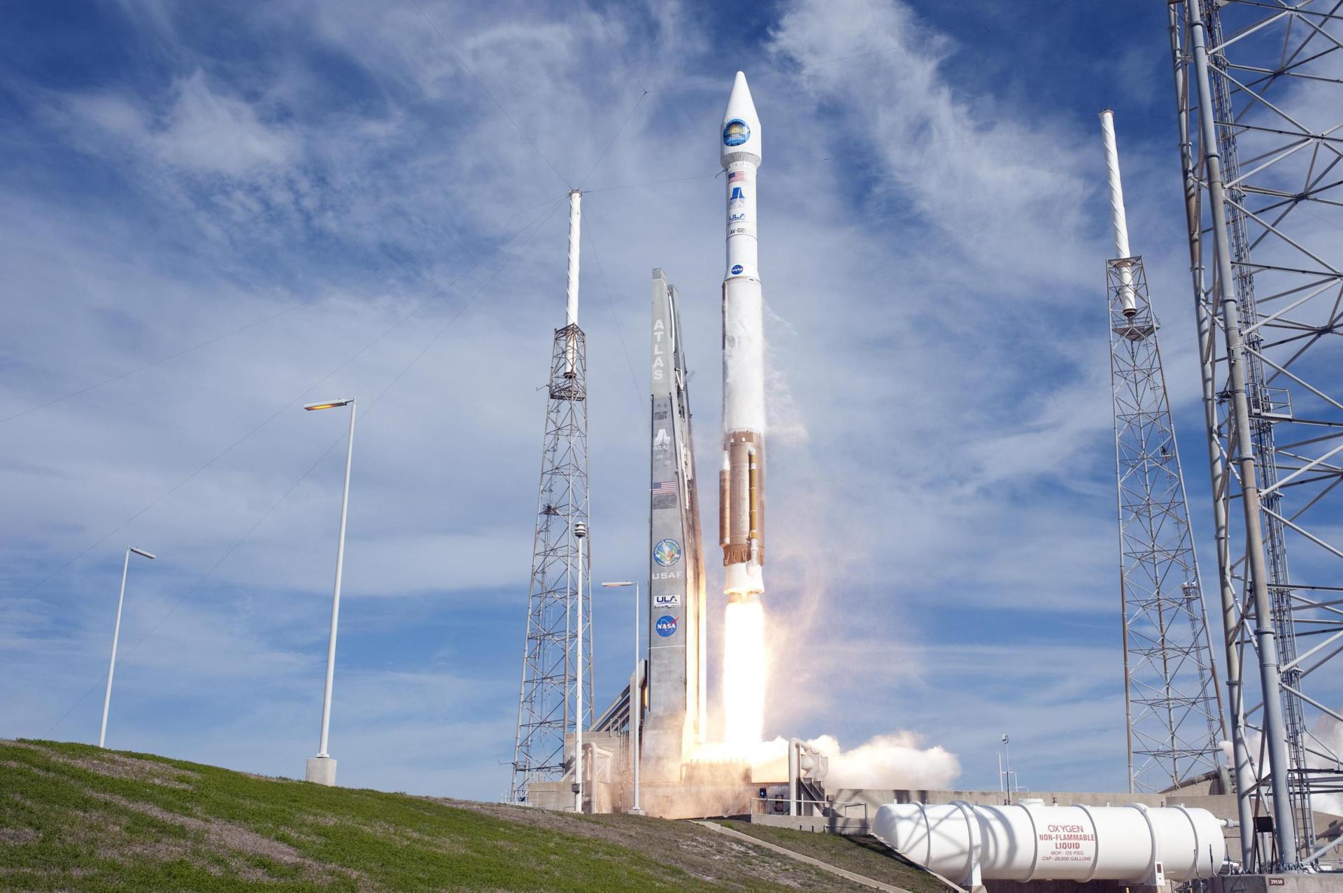
{ "count": 7820, "next": "https://ll.thespacedevs.com/2.0.0/launch/?format=api&limit=10&offset=300&ordering=-id", "previous": "https://ll.thespacedevs.com/2.0.0/launch/?format=api&limit=10&offset=280&ordering=-id", "results": [ { "id": "f5b5ef3e-aa66-4c4e-914c-6a9da0349648", "url": "https://ll.thespacedevs.com/2.0.0/launch/f5b5ef3e-aa66-4c4e-914c-6a9da0349648/?format=api", "launch_library_id": null, "slug": "vega-c-harmony", "name": "Vega-C | Harmony", "status": { "id": 2, "name": "TBD" }, "net": "2029-12-31T00:00:00Z", "window_end": "2029-12-31T00:00:00Z", "window_start": "2029-12-31T00:00:00Z", "inhold": false, "tbdtime": true, "tbddate": true, "probability": null, "holdreason": "", "failreason": "", "hashtag": null, "launch_service_provider": { "id": 159, "url": "https://ll.thespacedevs.com/2.0.0/agencies/159/?format=api", "name": "Avio S.p.A", "type": "Commercial" }, "rocket": { "id": 8381, "configuration": { "id": 127, "launch_library_id": 163, "url": "https://ll.thespacedevs.com/2.0.0/config/launcher/127/?format=api", "name": "Vega-C", "family": "Vega", "full_name": "Vega-C", "variant": "" } }, "mission": { "id": 6962, "launch_library_id": null, "name": "Harmony", "description": "Harmony, ESA's 10th Earth Explorer mission, consists of 2 satellites that will orbit Earth in tandem with a Copernicus Sentinel-1 satellite in various configurations. The Harmony satellites’ synthetic aperture radar instruments will receive the Sentinel-1 satellite's radar signals that bounce back, or ‘backscatter’, from Earth’s surface. At the same time, Harmony’s thermal-infrared instruments provide complementary observations of the sea surface as well as the position and motion of clouds above it.", "launch_designator": null, "type": "Earth Science", "orbit": { "id": 17, "name": "Sun-Synchronous Orbit", "abbrev": "SSO" } }, "pad": { "id": 34, "url": "https://ll.thespacedevs.com/2.0.0/pad/34/?format=api", "agency_id": 115, "name": "Ariane Launch Area 1 (ELV)", "info_url": null, "wiki_url": "https://en.wikipedia.org/wiki/ELA-1", "map_url": "https://www.google.com/maps?q=5.236,-52.775", "latitude": "5.236", "longitude": "-52.775", "location": { "id": 13, "url": "https://ll.thespacedevs.com/2.0.0/location/13/?format=api", "name": "Guiana Space Centre, French Guiana", "country_code": "GUF", "map_image": "https://thespacedevs-prod.nyc3.digitaloceanspaces.com/media/map_images/location_13_20200803142412.jpg", "total_launch_count": 331, "total_landing_count": 0 }, "map_image": "https://thespacedevs-prod.nyc3.digitaloceanspaces.com/media/map_images/pad_34_20200803143527.jpg", "total_launch_count": 54 }, "webcast_live": false, "image": "https://thespacedevs-prod.nyc3.digitaloceanspaces.com/media/images/vega-c_image_20220713154437.jpg", "infographic": null, "program": [] }, { "id": "f5b4e66e-de48-4d67-a8ed-15fb5a30b456", "url": "https://ll.thespacedevs.com/2.0.0/launch/f5b4e66e-de48-4d67-a8ed-15fb5a30b456/?format=api", "launch_library_id": null, "slug": "proton-luch-3", "name": "Proton | Luch #3", "status": { "id": 3, "name": "Success" }, "net": "1989-12-27T11:10:00Z", "window_end": "1989-12-27T11:10:00Z", "window_start": "1989-12-27T11:10:00Z", "inhold": false, "tbdtime": false, "tbddate": false, "probability": null, "holdreason": "", "failreason": "", "hashtag": null, "launch_service_provider": { "id": 66, "url": "https://ll.thespacedevs.com/2.0.0/agencies/66/?format=api", "name": "Soviet Space Program", "type": "Government" }, "rocket": { "id": 6231, "configuration": { "id": 80, "launch_library_id": 99, "url": "https://ll.thespacedevs.com/2.0.0/config/launcher/80/?format=api", "name": "Proton", "family": "Proton / UR-500", "full_name": "Proton K/DM-2", "variant": "K/DM-2" } }, "mission": { "id": 4621, "launch_library_id": null, "name": "Luch #3", "description": "Geostationary communications satellite", "launch_designator": null, "type": "Communications", "orbit": { "id": 1, "name": "Geostationary Orbit", "abbrev": "Direct-GEO" } }, "pad": { "id": 15, "url": "https://ll.thespacedevs.com/2.0.0/pad/15/?format=api", "agency_id": null, "name": "200/39 (200L)", "info_url": null, "wiki_url": "", "map_url": "https://www.google.com/maps?q=46.039984,63.032093", "latitude": "46.039984", "longitude": "63.032093", "location": { "id": 15, "url": "https://ll.thespacedevs.com/2.0.0/location/15/?format=api", "name": "Baikonur Cosmodrome, Republic of Kazakhstan", "country_code": "KAZ", "map_image": "https://thespacedevs-prod.nyc3.digitaloceanspaces.com/media/map_images/location_15_20200803142517.jpg", "total_launch_count": 1560, "total_landing_count": 0 }, "map_image": "https://thespacedevs-prod.nyc3.digitaloceanspaces.com/media/map_images/pad_15_20200803143530.jpg", "total_launch_count": 167 }, "webcast_live": false, "image": "https://thespacedevs-prod.nyc3.digitaloceanspaces.com/media/images/proton_image_20231231095535.jpg", "infographic": null, "program": [] }, { "id": "f5b31e85-b6b9-420b-acc1-bda4c2434c88", "url": "https://ll.thespacedevs.com/2.0.0/launch/f5b31e85-b6b9-420b-acc1-bda4c2434c88/?format=api", "launch_library_id": null, "slug": "thor-slv-2a-agena-d-kh-4a-5", "name": "Thor SLV-2A Agena D | KH-4A 5", "status": { "id": 3, "name": "Success" }, "net": "1964-04-27T23:23:43Z", "window_end": "1964-04-27T23:23:43Z", "window_start": "1964-04-27T23:23:43Z", "inhold": false, "tbdtime": false, "tbddate": false, "probability": null, "holdreason": "", "failreason": null, "hashtag": null, "launch_service_provider": { "id": 161, "url": "https://ll.thespacedevs.com/2.0.0/agencies/161/?format=api", "name": "United States Air Force", "type": "Government" }, "rocket": { "id": 3277, "configuration": { "id": 417, "launch_library_id": null, "url": "https://ll.thespacedevs.com/2.0.0/config/launcher/417/?format=api", "name": "Thor SLV-2A Agena D", "family": "Thor", "full_name": "Thor SLV-2A Agena D", "variant": "SLV-2A Agena D" } }, "mission": { "id": 1699, "launch_library_id": null, "name": "KH-4A 5", "description": "The KH-4A (Keyhole-4A) was the fifth optical reconnaissance satellite version in the Corona-program.", "launch_designator": null, "type": "Government/Top Secret", "orbit": { "id": 8, "name": "Low Earth Orbit", "abbrev": "LEO" } }, "pad": { "id": 95, "url": "https://ll.thespacedevs.com/2.0.0/pad/95/?format=api", "agency_id": 161, "name": "Space Launch Complex 1W", "info_url": null, "wiki_url": "https://en.wikipedia.org/wiki/Vandenberg_Space_Launch_Complex_1", "map_url": "https://www.google.com/maps?q=34.7572,-120.6303", "latitude": "34.7572", "longitude": "-120.6303", "location": { "id": 11, "url": "https://ll.thespacedevs.com/2.0.0/location/11/?format=api", "name": "Vandenberg SFB, CA, USA", "country_code": "USA", "map_image": "https://thespacedevs-prod.nyc3.digitaloceanspaces.com/media/map_images/location_11_20200803142416.jpg", "total_launch_count": 870, "total_landing_count": 33 }, "map_image": "https://thespacedevs-prod.nyc3.digitaloceanspaces.com/media/map_images/pad_95_20200803143209.jpg", "total_launch_count": 56 }, "webcast_live": false, "image": "https://thespacedevs-prod.nyc3.digitaloceanspaces.com/media/images/thor_slv-2a_age_image_20251102055131.jpg", "infographic": null, "program": [] }, { "id": "f5af8c62-3f1c-4083-aac1-edc70bfcfa94", "url": "https://ll.thespacedevs.com/2.0.0/launch/f5af8c62-3f1c-4083-aac1-edc70bfcfa94/?format=api", "launch_library_id": null, "slug": "soyuz-u-zenit-4mkm-13", "name": "Soyuz U | Zenit-4MKM 13", "status": { "id": 3, "name": "Success" }, "net": "1978-03-10T10:42:00Z", "window_end": "1978-03-10T10:42:00Z", "window_start": "1978-03-10T10:42:00Z", "inhold": false, "tbdtime": false, "tbddate": false, "probability": null, "holdreason": "", "failreason": null, "hashtag": null, "launch_service_provider": { "id": 66, "url": "https://ll.thespacedevs.com/2.0.0/agencies/66/?format=api", "name": "Soviet Space Program", "type": "Government" }, "rocket": { "id": 4939, "configuration": { "id": 37, "launch_library_id": 35, "url": "https://ll.thespacedevs.com/2.0.0/config/launcher/37/?format=api", "name": "Soyuz U", "family": "Soyuz", "full_name": "Soyuz U", "variant": "" } }, "mission": { "id": 3355, "launch_library_id": null, "name": "Zenit-4MKM 13", "description": "High-resolution film-return Zenit reconnaissance satellite", "launch_designator": null, "type": "Government/Top Secret", "orbit": { "id": 8, "name": "Low Earth Orbit", "abbrev": "LEO" } }, "pad": { "id": 36, "url": "https://ll.thespacedevs.com/2.0.0/pad/36/?format=api", "agency_id": 163, "name": "43/3 (43L)", "info_url": null, "wiki_url": null, "map_url": "https://www.google.com/maps?q=62.9273,40.45", "latitude": "62.9273", "longitude": "40.45", "location": { "id": 6, "url": "https://ll.thespacedevs.com/2.0.0/location/6/?format=api", "name": "Plesetsk Cosmodrome, Russian Federation", "country_code": "RUS", "map_image": "https://thespacedevs-prod.nyc3.digitaloceanspaces.com/media/map_images/location_6_20200803142434.jpg", "total_launch_count": 1681, "total_landing_count": 0 }, "map_image": "https://thespacedevs-prod.nyc3.digitaloceanspaces.com/media/map_images/pad_36_20200803143534.jpg", "total_launch_count": 231 }, "webcast_live": false, "image": "https://thespacedevs-prod.nyc3.digitaloceanspaces.com/media/images/soyuz2520u_image_20190222031023.jpeg", "infographic": null, "program": [] }, { "id": "f5a7130d-9132-423a-9290-7a57cdcfc8fe", "url": "https://ll.thespacedevs.com/2.0.0/launch/f5a7130d-9132-423a-9290-7a57cdcfc8fe/?format=api", "launch_library_id": null, "slug": "delta-6920-8-lace-rme", "name": "Delta 6920-8 | LACE & RME", "status": { "id": 3, "name": "Success" }, "net": "1990-02-14T16:15:01Z", "window_end": "1990-02-14T16:15:01Z", "window_start": "1990-02-14T16:15:01Z", "inhold": false, "tbdtime": false, "tbddate": false, "probability": null, "holdreason": "", "failreason": null, "hashtag": null, "launch_service_provider": { "id": 161, "url": "https://ll.thespacedevs.com/2.0.0/agencies/161/?format=api", "name": "United States Air Force", "type": "Government" }, "rocket": { "id": 6244, "configuration": { "id": 299, "launch_library_id": null, "url": "https://ll.thespacedevs.com/2.0.0/config/launcher/299/?format=api", "name": "Delta II", "family": "Delta", "full_name": "Delta II 6920-8", "variant": "6920-8" } }, "mission": { "id": 4634, "launch_library_id": null, "name": "LACE & RME", "description": "SDI experiment to validate laser beam relay functions for a ballistic missile defense system", "launch_designator": null, "type": "Government/Top Secret", "orbit": { "id": 8, "name": "Low Earth Orbit", "abbrev": "LEO" } }, "pad": { "id": 1, "url": "https://ll.thespacedevs.com/2.0.0/pad/1/?format=api", "agency_id": null, "name": "Space Launch Complex 17B", "info_url": null, "wiki_url": "https://en.wikipedia.org/wiki/Cape_Canaveral_Space_Launch_Complex_17", "map_url": "https://www.google.com/maps?q=28.4458,-80.5657", "latitude": "28.4458", "longitude": "-80.5657", "location": { "id": 12, "url": "https://ll.thespacedevs.com/2.0.0/location/12/?format=api", "name": "Cape Canaveral SFS, FL, USA", "country_code": "USA", "map_image": "https://thespacedevs-prod.nyc3.digitaloceanspaces.com/media/map_images/location_12_20200803142519.jpg", "total_launch_count": 1096, "total_landing_count": 71 }, "map_image": "https://thespacedevs-prod.nyc3.digitaloceanspaces.com/media/map_images/pad_1_20200803143208.jpg", "total_launch_count": 132 }, "webcast_live": false, "image": null, "infographic": null, "program": [] }, { "id": "f5a5ba75-16c4-4f30-9262-3195a2016f44", "url": "https://ll.thespacedevs.com/2.0.0/launch/f5a5ba75-16c4-4f30-9262-3195a2016f44/?format=api", "launch_library_id": null, "slug": "falcon-9-block-5-starlink-group-2-6-ion-scv009", "name": "Falcon 9 Block 5 | Starlink Group 2-6 & ION SCV009", "status": { "id": 3, "name": "Success" }, "net": "2023-01-31T16:15:00Z", "window_end": "2023-01-31T16:15:00Z", "window_start": "2023-01-31T16:15:00Z", "inhold": false, "tbdtime": false, "tbddate": false, "probability": null, "holdreason": "", "failreason": "", "hashtag": null, "launch_service_provider": { "id": 121, "url": "https://ll.thespacedevs.com/2.0.0/agencies/121/?format=api", "name": "SpaceX", "type": "Commercial" }, "rocket": { "id": 7735, "configuration": { "id": 164, "launch_library_id": 188, "url": "https://ll.thespacedevs.com/2.0.0/config/launcher/164/?format=api", "name": "Falcon 9", "family": "Falcon", "full_name": "Falcon 9 Block 5", "variant": "Block 5" } }, "mission": { "id": 6253, "launch_library_id": null, "name": "Starlink Group 2-6 & ION SCV009", "description": "A batch of 49 satellites for the Starlink mega-constellation - SpaceX's project for space-based Internet communication system.\r\n\r\nThis launch carries D-Orbit’s ION SCV009 Eclectic Elena as a rideshare payload.", "launch_designator": null, "type": "Communications", "orbit": { "id": 8, "name": "Low Earth Orbit", "abbrev": "LEO" } }, "pad": { "id": 16, "url": "https://ll.thespacedevs.com/2.0.0/pad/16/?format=api", "agency_id": null, "name": "Space Launch Complex 4E", "info_url": null, "wiki_url": "https://en.wikipedia.org/wiki/Vandenberg_Space_Launch_Complex_4#SLC-4E", "map_url": "https://www.google.com/maps?q=34.632,-120.611", "latitude": "34.632", "longitude": "-120.611", "location": { "id": 11, "url": "https://ll.thespacedevs.com/2.0.0/location/11/?format=api", "name": "Vandenberg SFB, CA, USA", "country_code": "USA", "map_image": "https://thespacedevs-prod.nyc3.digitaloceanspaces.com/media/map_images/location_11_20200803142416.jpg", "total_launch_count": 870, "total_landing_count": 33 }, "map_image": "https://thespacedevs-prod.nyc3.digitaloceanspaces.com/media/map_images/pad_16_20200803143532.jpg", "total_launch_count": 255 }, "webcast_live": false, "image": "https://thespacedevs-prod.nyc3.digitaloceanspaces.com/media/images/falcon2520925_image_20221009234147.png", "infographic": null, "program": [ { "id": 25, "url": "https://ll.thespacedevs.com/2.0.0/program/25/?format=api", "name": "Starlink", "description": "Starlink is a satellite internet constellation operated by American aerospace company SpaceX", "agencies": [ { "id": 121, "url": "https://ll.thespacedevs.com/2.0.0/agencies/121/?format=api", "name": "SpaceX", "type": "Commercial" } ], "image_url": "https://thespacedevs-prod.nyc3.digitaloceanspaces.com/media/images/starlink_program_20231228154508.jpeg", "start_date": "2018-02-22T14:17:00Z", "end_date": null, "info_url": "https://starlink.com", "wiki_url": "https://en.wikipedia.org/wiki/Starlink" } ] }, { "id": "f5a3eb4c-9eb5-4e28-acfb-7903a9e11371", "url": "https://ll.thespacedevs.com/2.0.0/launch/f5a3eb4c-9eb5-4e28-acfb-7903a9e11371/?format=api", "launch_library_id": null, "slug": "falcon-9-block-5-starlink-group-5-9", "name": "Falcon 9 Block 5 | Starlink Group 5-9", "status": { "id": 3, "name": "Success" }, "net": "2023-05-14T05:03:50Z", "window_end": "2023-05-14T05:03:50Z", "window_start": "2023-05-14T05:03:50Z", "inhold": false, "tbdtime": false, "tbddate": false, "probability": 95, "holdreason": "", "failreason": "", "hashtag": null, "launch_service_provider": { "id": 121, "url": "https://ll.thespacedevs.com/2.0.0/agencies/121/?format=api", "name": "SpaceX", "type": "Commercial" }, "rocket": { "id": 7838, "configuration": { "id": 164, "launch_library_id": 188, "url": "https://ll.thespacedevs.com/2.0.0/config/launcher/164/?format=api", "name": "Falcon 9", "family": "Falcon", "full_name": "Falcon 9 Block 5", "variant": "Block 5" } }, "mission": { "id": 6342, "launch_library_id": null, "name": "Starlink Group 5-9", "description": "A batch of 56 satellites for the Starlink mega-constellation - SpaceX's project for space-based Internet communication system.", "launch_designator": null, "type": "Communications", "orbit": { "id": 8, "name": "Low Earth Orbit", "abbrev": "LEO" } }, "pad": { "id": 80, "url": "https://ll.thespacedevs.com/2.0.0/pad/80/?format=api", "agency_id": 121, "name": "Space Launch Complex 40", "info_url": null, "wiki_url": "https://en.wikipedia.org/wiki/Cape_Canaveral_Air_Force_Station_Space_Launch_Complex_40", "map_url": "https://www.google.com/maps?q=28.56194122,-80.57735736", "latitude": "28.56194122", "longitude": "-80.57735736", "location": { "id": 12, "url": "https://ll.thespacedevs.com/2.0.0/location/12/?format=api", "name": "Cape Canaveral SFS, FL, USA", "country_code": "USA", "map_image": "https://thespacedevs-prod.nyc3.digitaloceanspaces.com/media/map_images/location_12_20200803142519.jpg", "total_launch_count": 1096, "total_landing_count": 71 }, "map_image": "https://thespacedevs-prod.nyc3.digitaloceanspaces.com/media/map_images/pad_80_20200803143323.jpg", "total_launch_count": 373 }, "webcast_live": false, "image": "https://thespacedevs-prod.nyc3.digitaloceanspaces.com/media/images/falcon2520925_image_20221009234147.png", "infographic": null, "program": [ { "id": 25, "url": "https://ll.thespacedevs.com/2.0.0/program/25/?format=api", "name": "Starlink", "description": "Starlink is a satellite internet constellation operated by American aerospace company SpaceX", "agencies": [ { "id": 121, "url": "https://ll.thespacedevs.com/2.0.0/agencies/121/?format=api", "name": "SpaceX", "type": "Commercial" } ], "image_url": "https://thespacedevs-prod.nyc3.digitaloceanspaces.com/media/images/starlink_program_20231228154508.jpeg", "start_date": "2018-02-22T14:17:00Z", "end_date": null, "info_url": "https://starlink.com", "wiki_url": "https://en.wikipedia.org/wiki/Starlink" } ] }, { "id": "f59752ea-55e2-44b3-8bb4-024534d104ad", "url": "https://ll.thespacedevs.com/2.0.0/launch/f59752ea-55e2-44b3-8bb4-024534d104ad/?format=api", "launch_library_id": 526, "slug": "atlas-v-401-sbirs-geo-flight-2-usa-241-sbirs-geo-2", "name": "Atlas V 401 | SBIRS GEO Flight 2 (USA-241) (SBIRS GEO-2)", "status": { "id": 3, "name": "Success" }, "net": "2013-03-19T21:21:00Z", "window_end": "2013-03-19T21:21:00Z", "window_start": "2013-03-19T21:21:00Z", "inhold": false, "tbdtime": false, "tbddate": false, "probability": null, "holdreason": "", "failreason": null, "hashtag": null, "launch_service_provider": { "id": 124, "url": "https://ll.thespacedevs.com/2.0.0/agencies/124/?format=api", "name": "United Launch Alliance", "type": "Commercial" }, "rocket": { "id": 1665, "configuration": { "id": 16, "launch_library_id": 26, "url": "https://ll.thespacedevs.com/2.0.0/config/launcher/16/?format=api", "name": "Atlas V 401", "family": "Atlas", "full_name": "Atlas V 401", "variant": "401" } }, "mission": { "id": 1, "launch_library_id": 29, "name": "SBIRS GEO Flight 2 (USA-241) (SBIRS GEO-2)", "description": "This geostationary satellite is tasked with providing capabilities for early missile warning and missile defense.", "launch_designator": null, "type": "Government/Top Secret", "orbit": { "id": 2, "name": "Geostationary Transfer Orbit", "abbrev": "GTO" } }, "pad": { "id": 29, "url": "https://ll.thespacedevs.com/2.0.0/pad/29/?format=api", "agency_id": null, "name": "Space Launch Complex 41", "info_url": null, "wiki_url": "https://en.wikipedia.org/wiki/Cape_Canaveral_Air_Force_Station_Space_Launch_Complex_41", "map_url": "https://www.google.com/maps?q=28.58341025,-80.58303644", "latitude": "28.58341025", "longitude": "-80.58303644", "location": { "id": 12, "url": "https://ll.thespacedevs.com/2.0.0/location/12/?format=api", "name": "Cape Canaveral SFS, FL, USA", "country_code": "USA", "map_image": "https://thespacedevs-prod.nyc3.digitaloceanspaces.com/media/map_images/location_12_20200803142519.jpg", "total_launch_count": 1096, "total_landing_count": 71 }, "map_image": "https://thespacedevs-prod.nyc3.digitaloceanspaces.com/media/map_images/pad_29_20200803143528.jpg", "total_launch_count": 121 }, "webcast_live": false, "image": "https://thespacedevs-prod.nyc3.digitaloceanspaces.com/media/images/atlas_v_image_20201212013334.jpeg", "infographic": null, "program": [] }, { "id": "f596ad48-881e-47d6-806d-113c6dd97427", "url": "https://ll.thespacedevs.com/2.0.0/launch/f596ad48-881e-47d6-806d-113c6dd97427/?format=api", "launch_library_id": null, "slug": "pegasus-xl-swift-rescue-mission", "name": "Pegasus XL | Swift Rescue Mission", "status": { "id": 2, "name": "TBD" }, "net": "2026-06-01T00:00:00Z", "window_end": "2026-06-01T00:00:00Z", "window_start": "2026-06-01T00:00:00Z", "inhold": false, "tbdtime": true, "tbddate": false, "probability": null, "holdreason": "", "failreason": "", "hashtag": null, "launch_service_provider": { "id": 257, "url": "https://ll.thespacedevs.com/2.0.0/agencies/257/?format=api", "name": "Northrop Grumman Space Systems", "type": "Commercial" }, "rocket": { "id": 8811, "configuration": { "id": 173, "launch_library_id": 8, "url": "https://ll.thespacedevs.com/2.0.0/config/launcher/173/?format=api", "name": "Pegasus XL", "family": "Pegasus", "full_name": "Pegasus XL", "variant": "" } }, "mission": { "id": 7402, "launch_library_id": null, "name": "Swift Rescue Mission", "description": "Contracted by NASA under the Small Business Innovation Research Phase 3 contract, Katalyst Space Technologies' LINK servicing spacecraft will rendezvous and attach to NASA’s Neil Gehrels Swift Observatory to re-boost its orbit. This aims to demonstrate a key capability for the future of space exploration and extending the Swift mission’s science lifetime in gamma ray astronomy.", "launch_designator": null, "type": "Mission Extension", "orbit": { "id": 8, "name": "Low Earth Orbit", "abbrev": "LEO" } }, "pad": { "id": 59, "url": "https://ll.thespacedevs.com/2.0.0/pad/59/?format=api", "agency_id": null, "name": "Kwajalein Atoll", "info_url": null, "wiki_url": "https://en.wikipedia.org/wiki/Kwajalein_Atoll", "map_url": "https://www.google.com/maps?q=8.716667,167.733333", "latitude": "8.716667", "longitude": "167.733333", "location": { "id": 20, "url": "https://ll.thespacedevs.com/2.0.0/location/20/?format=api", "name": "Air launch to orbit", "country_code": "???", "map_image": "https://thespacedevs-prod.nyc3.digitaloceanspaces.com/media/map_images/location_20_20200803142433.jpg", "total_launch_count": 51, "total_landing_count": 0 }, "map_image": "https://thespacedevs-prod.nyc3.digitaloceanspaces.com/media/map_images/pad_59_20200803143427.jpg", "total_launch_count": 4 }, "webcast_live": false, "image": "https://thespacedevs-prod.nyc3.digitaloceanspaces.com/media/images/pegasus_xl_moun_image_20240307124328.jpeg", "infographic": null, "program": [] }, { "id": "f59238fc-483b-4128-add2-c6ce73e21b98", "url": "https://ll.thespacedevs.com/2.0.0/launch/f59238fc-483b-4128-add2-c6ce73e21b98/?format=api", "launch_library_id": null, "slug": "soyuz-u-zenit-6u-4", "name": "Soyuz U | Zenit-6U 4", "status": { "id": 3, "name": "Success" }, "net": "1977-10-11T15:14:00Z", "window_end": "1977-10-11T15:14:00Z", "window_start": "1977-10-11T15:14:00Z", "inhold": false, "tbdtime": false, "tbddate": false, "probability": null, "holdreason": "", "failreason": null, "hashtag": null, "launch_service_provider": { "id": 66, "url": "https://ll.thespacedevs.com/2.0.0/agencies/66/?format=api", "name": "Soviet Space Program", "type": "Government" }, "rocket": { "id": 4891, "configuration": { "id": 37, "launch_library_id": 35, "url": "https://ll.thespacedevs.com/2.0.0/config/launcher/37/?format=api", "name": "Soyuz U", "family": "Soyuz", "full_name": "Soyuz U", "variant": "" } }, "mission": { "id": 3307, "launch_library_id": null, "name": "Zenit-6U 4", "description": "Optical film-return reconnaissance satellite", "launch_designator": null, "type": "Government/Top Secret", "orbit": { "id": 8, "name": "Low Earth Orbit", "abbrev": "LEO" } }, "pad": { "id": 85, "url": "https://ll.thespacedevs.com/2.0.0/pad/85/?format=api", "agency_id": 163, "name": "43/4 (43R)", "info_url": null, "wiki_url": null, "map_url": "https://www.google.com/maps?q=62.92883,40.457098", "latitude": "62.92883", "longitude": "40.457098", "location": { "id": 6, "url": "https://ll.thespacedevs.com/2.0.0/location/6/?format=api", "name": "Plesetsk Cosmodrome, Russian Federation", "country_code": "RUS", "map_image": "https://thespacedevs-prod.nyc3.digitaloceanspaces.com/media/map_images/location_6_20200803142434.jpg", "total_launch_count": 1681, "total_landing_count": 0 }, "map_image": "https://thespacedevs-prod.nyc3.digitaloceanspaces.com/media/map_images/pad_85_20200803143554.jpg", "total_launch_count": 326 }, "webcast_live": false, "image": "https://thespacedevs-prod.nyc3.digitaloceanspaces.com/media/images/soyuz2520u_image_20190222031023.jpeg", "infographic": null, "program": [] } ] }