Launch List
API endpoint that returns all Launch objects or a single launch.
EXAMPLE - /launch/
GET: Return a list of all Launch objects.
FILTERS: Fields - 'name', 'id(s)', 'lsp_id', 'lsp_name', 'serial_number', 'launcher_config__id', 'rocket__spacecraftflight__spacecraft__name'
MODE: 'normal', 'list', 'detailed' EXAMPLE: ?mode=list
SEARCH: Searches through the launch name, rocket name, launch agency, mission name & spacecraft name. EXAMPLE - ?search=SpaceX
GET /2.0.0/launch/?format=api&offset=250&ordering=-id
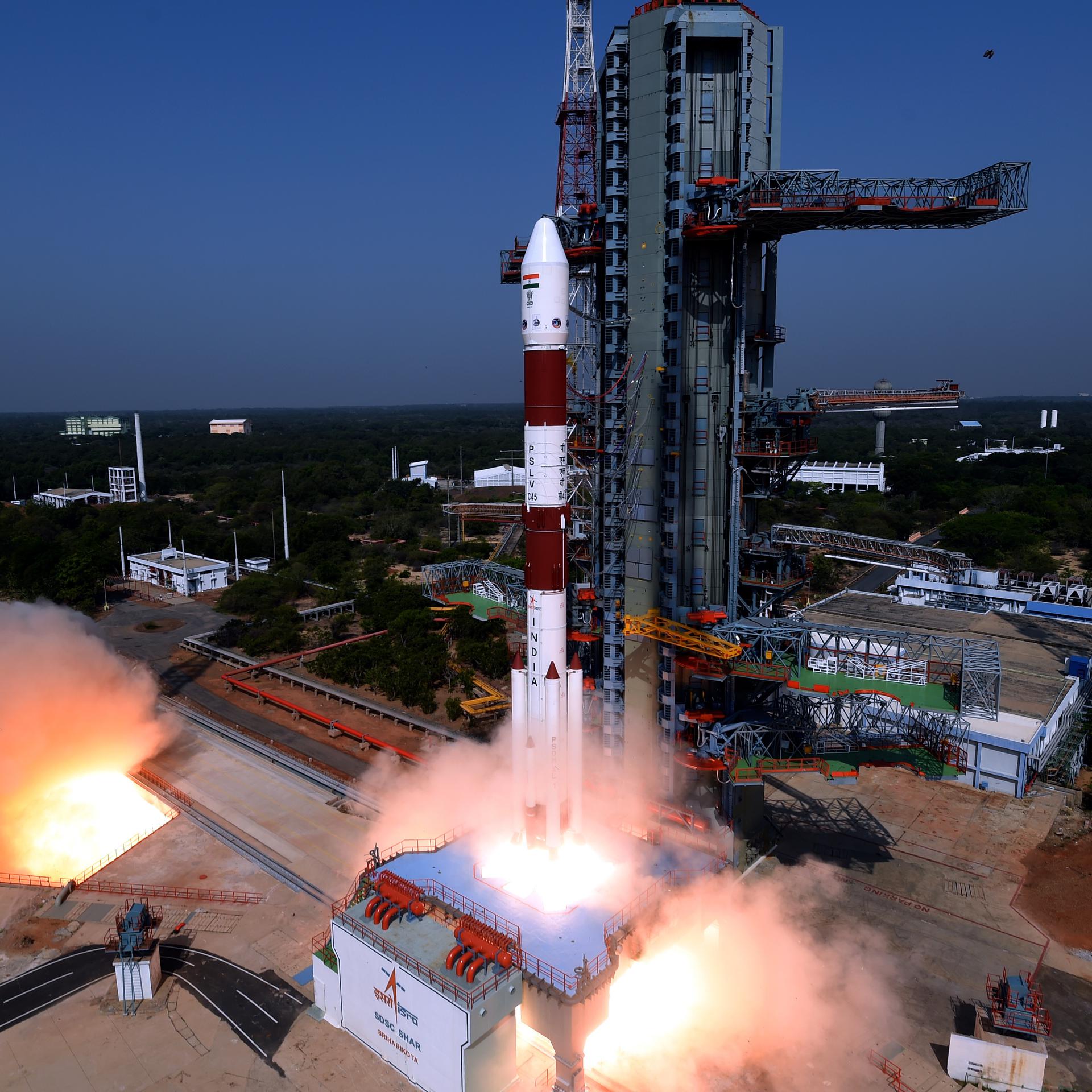
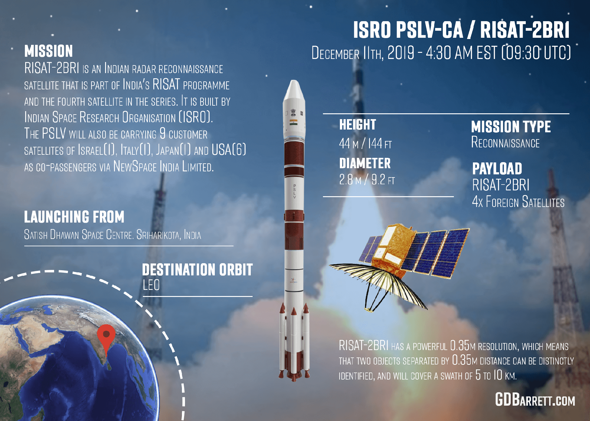
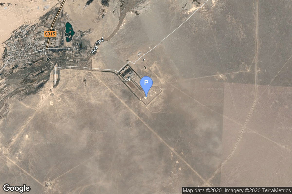
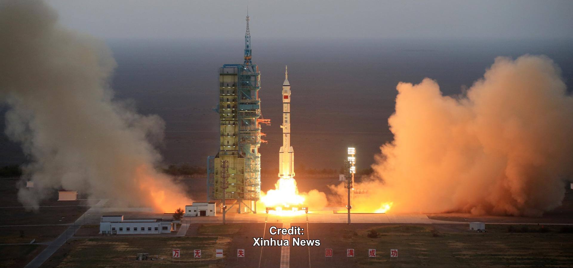
{ "count": 7608, "next": "https://ll.thespacedevs.com/2.0.0/launch/?format=api&limit=10&offset=260&ordering=-id", "previous": "https://ll.thespacedevs.com/2.0.0/launch/?format=api&limit=10&offset=240&ordering=-id", "results": [ { "id": "f70e2ebb-8ea1-4b0c-8831-7c6306be40d7", "url": "https://ll.thespacedevs.com/2.0.0/launch/f70e2ebb-8ea1-4b0c-8831-7c6306be40d7/?format=api", "launch_library_id": null, "slug": "tsiklon-2-us-p-13", "name": "Tsiklon-2 | US-P 13", "status": { "id": 3, "name": "Success" }, "net": "1982-02-11T01:11:00Z", "window_end": "1982-02-11T01:11:00Z", "window_start": "1982-02-11T01:11:00Z", "inhold": false, "tbdtime": false, "tbddate": false, "probability": null, "holdreason": "", "failreason": null, "hashtag": null, "launch_service_provider": { "id": 66, "url": "https://ll.thespacedevs.com/2.0.0/agencies/66/?format=api", "name": "Soviet Space Program", "type": "Government" }, "rocket": { "id": 5364, "configuration": { "id": 443, "launch_library_id": null, "url": "https://ll.thespacedevs.com/2.0.0/config/launcher/443/?format=api", "name": "Tsiklon-2", "family": "Tsiklon", "full_name": "Tsiklon-2", "variant": "2" } }, "mission": { "id": 3771, "launch_library_id": null, "name": "US-P 13", "description": "Ocean surveillance satellite using passive ELINT devices", "launch_designator": null, "type": "Government/Top Secret", "orbit": { "id": 8, "name": "Low Earth Orbit", "abbrev": "LEO" } }, "pad": { "id": 132, "url": "https://ll.thespacedevs.com/2.0.0/pad/132/?format=api", "agency_id": null, "name": "90", "info_url": null, "wiki_url": "https://en.wikipedia.org/wiki/Baikonur_Cosmodrome_Site_90", "map_url": "https://www.google.com/maps?q=46.081,62.929806", "latitude": "46.081", "longitude": "62.929806", "location": { "id": 15, "url": "https://ll.thespacedevs.com/2.0.0/location/15/?format=api", "name": "Baikonur Cosmodrome, Republic of Kazakhstan", "country_code": "KAZ", "map_image": "https://thespacedevs-prod.nyc3.digitaloceanspaces.com/media/map_images/location_15_20200803142517.jpg", "total_launch_count": 1558, "total_landing_count": 0 }, "map_image": "https://thespacedevs-prod.nyc3.digitaloceanspaces.com/media/map_images/pad_132_20200803143344.jpg", "total_launch_count": 74 }, "webcast_live": false, "image": "https://thespacedevs-prod.nyc3.digitaloceanspaces.com/media/images/tsyklon-2_lifto_image_20240411113159.jpg", "infographic": null, "program": [] }, { "id": "f70762c1-22f6-45a4-b2e4-a3ca2927ad6f", "url": "https://ll.thespacedevs.com/2.0.0/launch/f70762c1-22f6-45a4-b2e4-a3ca2927ad6f/?format=api", "launch_library_id": null, "slug": "thor-delta-c-oso-c", "name": "Thor Delta C | OSO C", "status": { "id": 4, "name": "Failure" }, "net": "1965-08-25T15:17:00Z", "window_end": "1965-08-25T15:17:00Z", "window_start": "1965-08-25T15:17:00Z", "inhold": false, "tbdtime": false, "tbddate": false, "probability": null, "holdreason": "", "failreason": null, "hashtag": null, "launch_service_provider": { "id": 161, "url": "https://ll.thespacedevs.com/2.0.0/agencies/161/?format=api", "name": "United States Air Force", "type": "Government" }, "rocket": { "id": 3431, "configuration": { "id": 401, "launch_library_id": null, "url": "https://ll.thespacedevs.com/2.0.0/config/launcher/401/?format=api", "name": "Thor Delta C", "family": "Thor", "full_name": "Thor Delta C", "variant": "Delta C" } }, "mission": { "id": 1851, "launch_library_id": null, "name": "OSO C", "description": "OSO (Orbital Solar Observatory) satellite. Its purpose was to return data on the ultraviolet, X-ray and gamma ray emissions of the sun and galaxy.", "launch_designator": null, "type": "Astrophysics", "orbit": { "id": 8, "name": "Low Earth Orbit", "abbrev": "LEO" } }, "pad": { "id": 1, "url": "https://ll.thespacedevs.com/2.0.0/pad/1/?format=api", "agency_id": null, "name": "Space Launch Complex 17B", "info_url": null, "wiki_url": "https://en.wikipedia.org/wiki/Cape_Canaveral_Space_Launch_Complex_17", "map_url": "https://www.google.com/maps?q=28.4458,-80.5657", "latitude": "28.4458", "longitude": "-80.5657", "location": { "id": 12, "url": "https://ll.thespacedevs.com/2.0.0/location/12/?format=api", "name": "Cape Canaveral SFS, FL, USA", "country_code": "USA", "map_image": "https://thespacedevs-prod.nyc3.digitaloceanspaces.com/media/map_images/location_12_20200803142519.jpg", "total_launch_count": 1054, "total_landing_count": 68 }, "map_image": "https://thespacedevs-prod.nyc3.digitaloceanspaces.com/media/map_images/pad_1_20200803143208.jpg", "total_launch_count": 132 }, "webcast_live": false, "image": null, "infographic": null, "program": [] }, { "id": "f7034397-80d8-416b-a3fc-c65341033524", "url": "https://ll.thespacedevs.com/2.0.0/launch/f7034397-80d8-416b-a3fc-c65341033524/?format=api", "launch_library_id": null, "slug": "kosmos-3m-taifun-2-26", "name": "Kosmos-3M | Taifun-2 26", "status": { "id": 4, "name": "Failure" }, "net": "1991-06-25T13:20:00Z", "window_end": "1991-06-25T13:20:00Z", "window_start": "1991-06-25T13:20:00Z", "inhold": false, "tbdtime": false, "tbddate": false, "probability": null, "holdreason": "", "failreason": null, "hashtag": null, "launch_service_provider": { "id": 66, "url": "https://ll.thespacedevs.com/2.0.0/agencies/66/?format=api", "name": "Soviet Space Program", "type": "Government" }, "rocket": { "id": 6376, "configuration": { "id": 102, "launch_library_id": 122, "url": "https://ll.thespacedevs.com/2.0.0/config/launcher/102/?format=api", "name": "Kosmos-3M", "family": "Kosmos", "full_name": "Kosmos-3M (11K65M)", "variant": "-3M" } }, "mission": { "id": 4766, "launch_library_id": null, "name": "Taifun-2 26", "description": "Taifun-2 satellite used to release up to 24 subsatellites for radar and sensor calibration", "launch_designator": null, "type": "Test Target", "orbit": { "id": 8, "name": "Low Earth Orbit", "abbrev": "LEO" } }, "pad": { "id": 28, "url": "https://ll.thespacedevs.com/2.0.0/pad/28/?format=api", "agency_id": 163, "name": "132/1 (132L)", "info_url": null, "wiki_url": "", "map_url": "https://www.google.com/maps?q=62.883229,40.868549", "latitude": "62.883229", "longitude": "40.868549", "location": { "id": 6, "url": "https://ll.thespacedevs.com/2.0.0/location/6/?format=api", "name": "Plesetsk Cosmodrome, Russian Federation", "country_code": "RUS", "map_image": "https://thespacedevs-prod.nyc3.digitaloceanspaces.com/media/map_images/location_6_20200803142434.jpg", "total_launch_count": 1678, "total_landing_count": 0 }, "map_image": "https://thespacedevs-prod.nyc3.digitaloceanspaces.com/media/map_images/pad_28_20200803143254.jpg", "total_launch_count": 212 }, "webcast_live": false, "image": null, "infographic": null, "program": [] }, { "id": "f6ed3dcd-8bd8-4d49-98a8-2fd666442c32", "url": "https://ll.thespacedevs.com/2.0.0/launch/f6ed3dcd-8bd8-4d49-98a8-2fd666442c32/?format=api", "launch_library_id": 1929, "slug": "smart-dragon-1-maiden-flight", "name": "Smart Dragon 1 | Maiden Flight", "status": { "id": 3, "name": "Success" }, "net": "2019-08-17T04:11:40Z", "window_end": "2019-08-17T04:30:00Z", "window_start": "2019-08-17T04:00:00Z", "inhold": false, "tbdtime": false, "tbddate": false, "probability": -1, "holdreason": "", "failreason": "", "hashtag": null, "launch_service_provider": { "id": 272, "url": "https://ll.thespacedevs.com/2.0.0/agencies/272/?format=api", "name": "China Rocket Co. Ltd.", "type": "Commercial" }, "rocket": { "id": 2465, "configuration": { "id": 192, "launch_library_id": 221, "url": "https://ll.thespacedevs.com/2.0.0/config/launcher/192/?format=api", "name": "Smart Dragon 1", "family": "Smart Dragon", "full_name": "Smart Dragon 1", "variant": "" } }, "mission": { "id": 991, "launch_library_id": 1201, "name": "Maiden Flight", "description": "First launch of the new solid-fueled rocket by Chinarocket Co., Ltd., which is a commercial subsidiary of CASC. On this launch Smart Dragon 1 will also carry payloads for four private companies.", "launch_designator": null, "type": "Test Flight", "orbit": null }, "pad": { "id": 21, "url": "https://ll.thespacedevs.com/2.0.0/pad/21/?format=api", "agency_id": null, "name": "Launch Area 95A", "info_url": null, "wiki_url": "https://en.wikipedia.org/wiki/Jiuquan_Satellite_Launch_Center", "map_url": "https://www.google.com/maps?q=40.969117,100.343333", "latitude": "40.969117", "longitude": "100.343333", "location": { "id": 17, "url": "https://ll.thespacedevs.com/2.0.0/location/17/?format=api", "name": "Jiuquan Satellite Launch Center, People's Republic of China", "country_code": "CHN", "map_image": "https://thespacedevs-prod.nyc3.digitaloceanspaces.com/media/map_images/location_17_20200803142429.jpg", "total_launch_count": 258, "total_landing_count": 0 }, "map_image": "https://thespacedevs-prod.nyc3.digitaloceanspaces.com/media/map_images/pad_21_20200803143253.jpg", "total_launch_count": 61 }, "webcast_live": false, "image": null, "infographic": null, "program": [] }, { "id": "f6e14f90-a5dc-472e-acf6-4aac471ffb6b", "url": "https://ll.thespacedevs.com/2.0.0/launch/f6e14f90-a5dc-472e-acf6-4aac471ffb6b/?format=api", "launch_library_id": null, "slug": "vostok-zenit-2-2", "name": "Vostok | Zenit-2 2", "status": { "id": 3, "name": "Success" }, "net": "1962-04-26T10:02:00Z", "window_end": "1962-04-26T10:02:00Z", "window_start": "1962-04-26T10:02:00Z", "inhold": false, "tbdtime": false, "tbddate": false, "probability": null, "holdreason": "", "failreason": null, "hashtag": null, "launch_service_provider": { "id": 66, "url": "https://ll.thespacedevs.com/2.0.0/agencies/66/?format=api", "name": "Soviet Space Program", "type": "Government" }, "rocket": { "id": 3117, "configuration": { "id": 103, "launch_library_id": 139, "url": "https://ll.thespacedevs.com/2.0.0/config/launcher/103/?format=api", "name": "Vostok", "family": "R-7", "full_name": "Vostok-K", "variant": "K" } }, "mission": { "id": 1539, "launch_library_id": null, "name": "Zenit-2 2", "description": "Zenit-2 film-return and ELINT reconnaissance satellite.", "launch_designator": null, "type": "Government/Top Secret", "orbit": { "id": 8, "name": "Low Earth Orbit", "abbrev": "LEO" } }, "pad": { "id": 32, "url": "https://ll.thespacedevs.com/2.0.0/pad/32/?format=api", "agency_id": null, "name": "1/5", "info_url": null, "wiki_url": "", "map_url": "https://www.google.com/maps?q=45.92,63.342", "latitude": "45.92", "longitude": "63.342", "location": { "id": 15, "url": "https://ll.thespacedevs.com/2.0.0/location/15/?format=api", "name": "Baikonur Cosmodrome, Republic of Kazakhstan", "country_code": "KAZ", "map_image": "https://thespacedevs-prod.nyc3.digitaloceanspaces.com/media/map_images/location_15_20200803142517.jpg", "total_launch_count": 1558, "total_landing_count": 0 }, "map_image": "https://thespacedevs-prod.nyc3.digitaloceanspaces.com/media/map_images/pad_32_20200803143513.jpg", "total_launch_count": 487 }, "webcast_live": false, "image": "https://thespacedevs-prod.nyc3.digitaloceanspaces.com/media/images/vostok_image_20191104130128.jpg", "infographic": null, "program": [] }, { "id": "f6dd06a3-0e95-4b16-8ed0-12626be6ec75", "url": "https://ll.thespacedevs.com/2.0.0/launch/f6dd06a3-0e95-4b16-8ed0-12626be6ec75/?format=api", "launch_library_id": null, "slug": "ariane-44l-intelsat-904", "name": "Ariane 44L | INTELSAT 904", "status": { "id": 3, "name": "Success" }, "net": "2002-02-23T06:59:00Z", "window_end": "2002-02-23T06:59:00Z", "window_start": "2002-02-23T06:59:00Z", "inhold": false, "tbdtime": false, "tbddate": false, "probability": null, "holdreason": "", "failreason": null, "hashtag": null, "launch_service_provider": { "id": 115, "url": "https://ll.thespacedevs.com/2.0.0/agencies/115/?format=api", "name": "Arianespace", "type": "Commercial" }, "rocket": { "id": 7077, "configuration": { "id": 225, "launch_library_id": null, "url": "https://ll.thespacedevs.com/2.0.0/config/launcher/225/?format=api", "name": "Ariane 44L", "family": "Ariane", "full_name": "Ariane 44L", "variant": "44L" } }, "mission": { "id": 5466, "launch_library_id": null, "name": "INTELSAT 904", "description": "Intelsat 904 (or IS-904[1]) is a communications satellite operated by Intelsat.", "launch_designator": null, "type": "Communications", "orbit": { "id": 1, "name": "Geostationary Orbit", "abbrev": "Direct-GEO" } }, "pad": { "id": 124, "url": "https://ll.thespacedevs.com/2.0.0/pad/124/?format=api", "agency_id": 115, "name": "Ariane Launch Area 2", "info_url": null, "wiki_url": "https://en.wikipedia.org/wiki/ELA-2", "map_url": "https://www.google.com/maps?q=5.232,-52.778194", "latitude": "5.232", "longitude": "-52.778194", "location": { "id": 13, "url": "https://ll.thespacedevs.com/2.0.0/location/13/?format=api", "name": "Guiana Space Centre, French Guiana", "country_code": "GUF", "map_image": "https://thespacedevs-prod.nyc3.digitaloceanspaces.com/media/map_images/location_13_20200803142412.jpg", "total_launch_count": 327, "total_landing_count": 0 }, "map_image": "https://thespacedevs-prod.nyc3.digitaloceanspaces.com/media/map_images/pad_124_20200803143241.jpg", "total_launch_count": 119 }, "webcast_live": false, "image": "https://thespacedevs-prod.nyc3.digitaloceanspaces.com/media/images/ariane_44l_at_e_image_20240401082337.jpg", "infographic": null, "program": [] }, { "id": "f6c8d7c8-3320-4403-af1a-08f706102adf", "url": "https://ll.thespacedevs.com/2.0.0/launch/f6c8d7c8-3320-4403-af1a-08f706102adf/?format=api", "launch_library_id": null, "slug": "voskhod-zenit-4m-21", "name": "Voskhod | Zenit-4M 21", "status": { "id": 4, "name": "Failure" }, "net": "1971-08-19T06:30:00Z", "window_end": "1971-08-19T06:30:00Z", "window_start": "1971-08-19T06:30:00Z", "inhold": false, "tbdtime": false, "tbddate": false, "probability": null, "holdreason": "", "failreason": null, "hashtag": null, "launch_service_provider": { "id": 66, "url": "https://ll.thespacedevs.com/2.0.0/agencies/66/?format=api", "name": "Soviet Space Program", "type": "Government" }, "rocket": { "id": 4165, "configuration": { "id": 104, "launch_library_id": 138, "url": "https://ll.thespacedevs.com/2.0.0/config/launcher/104/?format=api", "name": "Voskhod", "family": "R-7", "full_name": "Voskhod", "variant": "Voskhod" } }, "mission": { "id": 2583, "launch_library_id": null, "name": "Zenit-4M 21", "description": "The soviet Zenit-4M (Rotor, 11F691) was an improved version of the Zenit-4 high resolution reconnaissance satellite and was part of the Vostok-based Zenit-family.", "launch_designator": null, "type": "Government/Top Secret", "orbit": { "id": 8, "name": "Low Earth Orbit", "abbrev": "LEO" } }, "pad": { "id": 20, "url": "https://ll.thespacedevs.com/2.0.0/pad/20/?format=api", "agency_id": null, "name": "31/6", "info_url": null, "wiki_url": "https://en.wikipedia.org/wiki/Baikonur_Cosmodrome_Site_31", "map_url": "https://www.google.com/maps?q=45.996034,63.564003", "latitude": "45.996034", "longitude": "63.564003", "location": { "id": 15, "url": "https://ll.thespacedevs.com/2.0.0/location/15/?format=api", "name": "Baikonur Cosmodrome, Republic of Kazakhstan", "country_code": "KAZ", "map_image": "https://thespacedevs-prod.nyc3.digitaloceanspaces.com/media/map_images/location_15_20200803142517.jpg", "total_launch_count": 1558, "total_landing_count": 0 }, "map_image": "https://thespacedevs-prod.nyc3.digitaloceanspaces.com/media/map_images/pad_20_20200803143516.jpg", "total_launch_count": 425 }, "webcast_live": false, "image": null, "infographic": null, "program": [] }, { "id": "f6b36638-fd51-4593-b09e-adb4d84fcfbd", "url": "https://ll.thespacedevs.com/2.0.0/launch/f6b36638-fd51-4593-b09e-adb4d84fcfbd/?format=api", "launch_library_id": 1616, "slug": "pslv-ql-risat-2br1-others", "name": "PSLV-QL | RISAT-2BR1 & others", "status": { "id": 3, "name": "Success" }, "net": "2019-12-11T09:55:00Z", "window_end": "2019-12-11T11:30:00Z", "window_start": "2019-12-11T09:30:00Z", "inhold": false, "tbdtime": false, "tbddate": false, "probability": -1, "holdreason": "", "failreason": null, "hashtag": null, "launch_service_provider": { "id": 31, "url": "https://ll.thespacedevs.com/2.0.0/agencies/31/?format=api", "name": "Indian Space Research Organization", "type": "Government" }, "rocket": { "id": 2587, "configuration": { "id": 181, "launch_library_id": 218, "url": "https://ll.thespacedevs.com/2.0.0/config/launcher/181/?format=api", "name": "PSLV-QL", "family": "PSLV", "full_name": "PSLV-QL", "variant": "QL" } }, "mission": { "id": 997, "launch_library_id": 1205, "name": "RISAT-2BR1 & others", "description": "Satellite imaging mission of ISRO using an active SAR (Synthetic Aperture Radar) imager to provide continuity of service for RISAT-2. Mission also carries several small satellites for international customers.", "launch_designator": null, "type": "Earth Science", "orbit": { "id": 8, "name": "Low Earth Orbit", "abbrev": "LEO" } }, "pad": { "id": 50, "url": "https://ll.thespacedevs.com/2.0.0/pad/50/?format=api", "agency_id": 31, "name": "Satish Dhawan Space Centre First Launch Pad", "info_url": null, "wiki_url": "https://en.wikipedia.org/wiki/Satish_Dhawan_Space_Centre_First_Launch_Pad", "map_url": "https://www.google.com/maps?q=13.733,80.235", "latitude": "13.733", "longitude": "80.235", "location": { "id": 14, "url": "https://ll.thespacedevs.com/2.0.0/location/14/?format=api", "name": "Satish Dhawan Space Centre, India", "country_code": "IND", "map_image": "https://thespacedevs-prod.nyc3.digitaloceanspaces.com/media/map_images/location_14_20200803142403.jpg", "total_launch_count": 100, "total_landing_count": 0 }, "map_image": "https://thespacedevs-prod.nyc3.digitaloceanspaces.com/media/map_images/pad_50_20200803143457.jpg", "total_launch_count": 62 }, "webcast_live": false, "image": "https://thespacedevs-prod.nyc3.digitaloceanspaces.com/media/images/pslv_image_20190508083736.jpeg", "infographic": "https://thespacedevs-prod.nyc3.digitaloceanspaces.com/media/infographic_images/pslv-ql252025_infographic_20200806040041.png", "program": [] }, { "id": "f6741a84-a631-417d-bb32-cf02d5daf132", "url": "https://ll.thespacedevs.com/2.0.0/launch/f6741a84-a631-417d-bb32-cf02d5daf132/?format=api", "launch_library_id": null, "slug": "soyuz-u-zenit-4mkt-7", "name": "Soyuz U | Zenit-4MKT 7", "status": { "id": 3, "name": "Success" }, "net": "1978-10-03T11:00:00Z", "window_end": "1978-10-03T11:00:00Z", "window_start": "1978-10-03T11:00:00Z", "inhold": false, "tbdtime": false, "tbddate": false, "probability": null, "holdreason": "", "failreason": null, "hashtag": null, "launch_service_provider": { "id": 66, "url": "https://ll.thespacedevs.com/2.0.0/agencies/66/?format=api", "name": "Soviet Space Program", "type": "Government" }, "rocket": { "id": 4998, "configuration": { "id": 37, "launch_library_id": 35, "url": "https://ll.thespacedevs.com/2.0.0/config/launcher/37/?format=api", "name": "Soyuz U", "family": "Soyuz", "full_name": "Soyuz U", "variant": "" } }, "mission": { "id": 3412, "launch_library_id": null, "name": "Zenit-4MKT 7", "description": "Film-return reconnaissance satellite", "launch_designator": null, "type": "Government/Top Secret", "orbit": { "id": 8, "name": "Low Earth Orbit", "abbrev": "LEO" } }, "pad": { "id": 36, "url": "https://ll.thespacedevs.com/2.0.0/pad/36/?format=api", "agency_id": 163, "name": "43/3 (43L)", "info_url": null, "wiki_url": null, "map_url": "https://www.google.com/maps?q=62.9273,40.45", "latitude": "62.9273", "longitude": "40.45", "location": { "id": 6, "url": "https://ll.thespacedevs.com/2.0.0/location/6/?format=api", "name": "Plesetsk Cosmodrome, Russian Federation", "country_code": "RUS", "map_image": "https://thespacedevs-prod.nyc3.digitaloceanspaces.com/media/map_images/location_6_20200803142434.jpg", "total_launch_count": 1678, "total_landing_count": 0 }, "map_image": "https://thespacedevs-prod.nyc3.digitaloceanspaces.com/media/map_images/pad_36_20200803143534.jpg", "total_launch_count": 231 }, "webcast_live": false, "image": "https://thespacedevs-prod.nyc3.digitaloceanspaces.com/media/images/soyuz2520u_image_20190222031023.jpeg", "infographic": null, "program": [] }, { "id": "f672e9c9-2bae-4adf-ae70-09eda35d9837", "url": "https://ll.thespacedevs.com/2.0.0/launch/f672e9c9-2bae-4adf-ae70-09eda35d9837/?format=api", "launch_library_id": 629, "slug": "long-march-2fg-shenzhou-9-shenzhou-9-gc", "name": "Long March 2F/G | Shenzhou-9 & Shenzhou-9-GC", "status": { "id": 3, "name": "Success" }, "net": "2012-06-16T10:37:24Z", "window_end": "2012-06-16T10:37:24Z", "window_start": "2012-06-16T10:37:24Z", "inhold": false, "tbdtime": false, "tbddate": false, "probability": -1, "holdreason": "", "failreason": "", "hashtag": null, "launch_service_provider": { "id": 88, "url": "https://ll.thespacedevs.com/2.0.0/agencies/88/?format=api", "name": "China Aerospace Science and Technology Corporation", "type": "Government" }, "rocket": { "id": 1616, "configuration": { "id": 84, "launch_library_id": 111, "url": "https://ll.thespacedevs.com/2.0.0/config/launcher/84/?format=api", "name": "Long March 2", "family": "Long March", "full_name": "Long March 2F/G", "variant": "F/G" } }, "mission": { "id": 259, "launch_library_id": 354, "name": "Shenzhou-9 & Shenzhou-9-GC", "description": "This is the fourth crewed mission for China's Shenzhou program which lasted 12 days. Being the first crewed spacecraft to visit the Tiangong-1 space station, it brought up the astronauts Jing Haipeng, Liu Wang and the first Chinese female astronaut Lie Yang. They docked automatically to the station on 18 June. During their stay in the station, astronauts conducted various scientific and technological experiments, and performed manual re-docking on 24 June. Shenzhou 9 undocked on 29 June and landed safely back on Earth the same day.", "launch_designator": null, "type": "Human Exploration", "orbit": { "id": 8, "name": "Low Earth Orbit", "abbrev": "LEO" } }, "pad": { "id": 37, "url": "https://ll.thespacedevs.com/2.0.0/pad/37/?format=api", "agency_id": null, "name": "Launch Area 4 (SLS-1 / 921)", "info_url": null, "wiki_url": "https://en.wikipedia.org/wiki/Jiuquan_Launch_Area_4", "map_url": "https://www.google.com/maps?q=40.957893,100.290944", "latitude": "40.957893", "longitude": "100.290944", "location": { "id": 17, "url": "https://ll.thespacedevs.com/2.0.0/location/17/?format=api", "name": "Jiuquan Satellite Launch Center, People's Republic of China", "country_code": "CHN", "map_image": "https://thespacedevs-prod.nyc3.digitaloceanspaces.com/media/map_images/location_17_20200803142429.jpg", "total_launch_count": 258, "total_landing_count": 0 }, "map_image": "https://thespacedevs-prod.nyc3.digitaloceanspaces.com/media/map_images/pad_37_20200803143603.jpg", "total_launch_count": 25 }, "webcast_live": false, "image": "https://thespacedevs-prod.nyc3.digitaloceanspaces.com/media/images/long_march_2_image_20210908195835.jpeg", "infographic": null, "program": [ { "id": 7, "url": "https://ll.thespacedevs.com/2.0.0/program/7/?format=api", "name": "Shenzhou", "description": "The Shenzhou program is a crewed spaceflight initiative by China. The program put the first Chinese citizen, Yang Liwei, into orbit on 15 October 2003.", "agencies": [ { "id": 17, "url": "https://ll.thespacedevs.com/2.0.0/agencies/17/?format=api", "name": "China National Space Administration", "type": "Government" } ], "image_url": "https://thespacedevs-prod.nyc3.digitaloceanspaces.com/media/images/shenzhou_program_20200820204745.PNG", "start_date": "1993-01-01T00:00:00Z", "end_date": null, "info_url": null, "wiki_url": "https://en.wikipedia.org/wiki/Shenzhou_program" } ] } ] }